.jpg.93eb8afe5d1df4d67bc0eeb78d645380.jpg)
.jpg.7cbeb4b469bd18d447fac5868c43a091.jpg)
Yardstickgozinya
-
Posts
1,297 -
Joined
Content Type
Profiles
Blogs
Forums
American Weather
Media Demo
Store
Gallery
Everything posted by Yardstickgozinya
-
.thumb.jpg.6a4895b2a43f87359e4e7d04a6fa0d14.jpg)
Central PA Spring 2026 Discussion/Obs Thread
Yardstickgozinya replied to Voyager's topic in Upstate New York/Pennsylvania
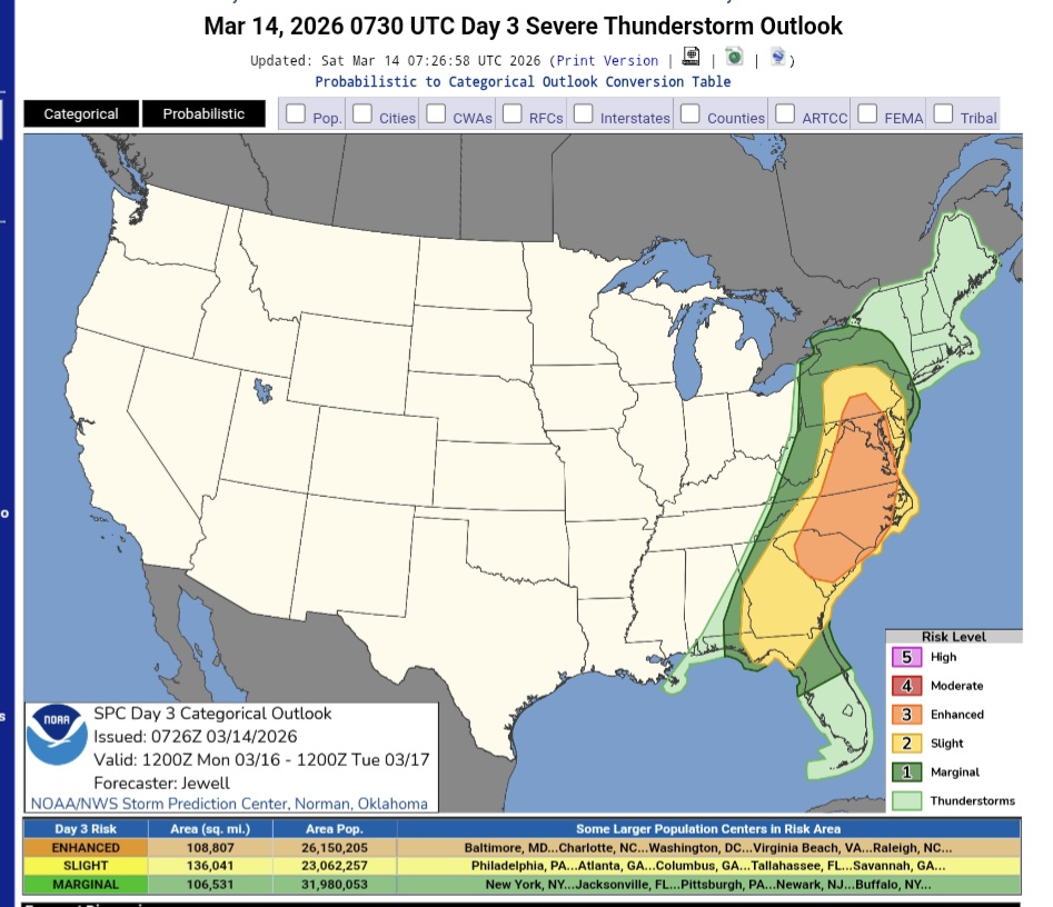
https://www.spc.noaa.gov/products/outlook/day3otlk.html
-
Central PA Spring 2026 Discussion/Obs Thread
Yardstickgozinya replied to Voyager's topic in Upstate New York/Pennsylvania
Bounded weak echo region is another thing that came to mind, but I would think it would have a lot more lightning. -
Central PA Spring 2026 Discussion/Obs Thread
Yardstickgozinya replied to Voyager's topic in Upstate New York/Pennsylvania
Yes, I may have a wrong picture, but one is coming together. Lol I believe the storm was cycling in the signatures that @mahantango#1 posted and we're seeing the very moment the old inflow, notch closed up. I also believe the storm probably cycled like this several times before it could form a tornado. @MAG5035 feel free to to let me down.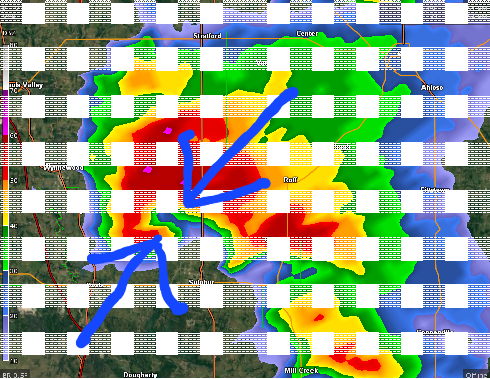
-
Central PA Spring 2026 Discussion/Obs Thread
Yardstickgozinya replied to Voyager's topic in Upstate New York/Pennsylvania
You were under some of that convection, or you're just getting wind/rain -
Central PA Spring 2026 Discussion/Obs Thread
Yardstickgozinya replied to Voyager's topic in Upstate New York/Pennsylvania
Yeah, just kinda looks to me like it closed off Its feed of cooler dry air to the meso and you're just seeing what's left of it getting pinch to the center, and that's also probably what killed any chance of it forming a tornado. I could be completely wrong because I don't have access to watch it again and can't see the whole storm in the images. I included a picture of a cell below that is showing circulation beginning to dog leg. You can see the mesocyclone, catching up with the rear flank of the precipitation core and eventually, if they merge and you catch it at the right moment, that close off point can certainly can be confused for a debris ball. I want to reiterate that this is not our super sell from the other day. This is just one I chose for the dog leg.
-
Central PA Spring 2026 Discussion/Obs Thread
Yardstickgozinya replied to Voyager's topic in Upstate New York/Pennsylvania
And just to be clear, anybody could make that mistake with their eyes . That's why surveys are so necessary even with radar confirmation. -
Central PA Spring 2026 Discussion/Obs Thread
Yardstickgozinya replied to Voyager's topic in Upstate New York/Pennsylvania
So while i'm already looking stupid, it's probably a good time to add my stupid analysis. I don't have the means to go back and look at this nor did I ever see it in such high detail but it looks to me like the circulation dog leged and just embedded itself into the cell giving the illusion of a the debris ball. -
Central PA Spring 2026 Discussion/Obs Thread
Yardstickgozinya replied to Voyager's topic in Upstate New York/Pennsylvania
LOL it's even circled in the corner. I was looking for a supercell and my eye just immediately said, what the hell is that and just never connected the history of the date. But anywho the wind has died down here and the spring peepers are actually still chirping tonight, so it's not bad out here at all, while i'm wrapping up work in Mechanicsburg. -
Central PA Spring 2026 Discussion/Obs Thread
Yardstickgozinya replied to Voyager's topic in Upstate New York/Pennsylvania
I think you had an upload error -
Central PA Spring 2026 Discussion/Obs Thread
Yardstickgozinya replied to Voyager's topic in Upstate New York/Pennsylvania
Quasi linear convective system with embedded rotations is the mode they keep throwing out although there is talks of more discrete development out ahead, even into Pennsylvania. I would indeed bet that some of those segments, and even the whole line could qualify ifor derecho status if the parameters should be realized. -
Central PA Spring 2026 Discussion/Obs Thread
Yardstickgozinya replied to Voyager's topic in Upstate New York/Pennsylvania
Oh, I still haven't heard it mentioned anywhere.It was just an observation of mine. -
Central PA Spring 2026 Discussion/Obs Thread
Yardstickgozinya replied to Voyager's topic in Upstate New York/Pennsylvania
With possible embedded rotations -
Central PA Spring 2026 Discussion/Obs Thread
Yardstickgozinya replied to Voyager's topic in Upstate New York/Pennsylvania
Yes, extremely interesting. I also am hearing that an extremely potent jet streak it is expected to enhance convection and sheer from the middle Mississippi into the Ohio valley Sunday night into Monday . The last time I think any of us saw such robust nighttime convection this early in the season was 2011 and even that benchmark season waited until mid April to start it's nocturnal shenanigans. Apparently, the situation could be a lot more ominous had the last system not kicked the moisture. -
Central PA Spring 2026 Discussion/Obs Thread
Yardstickgozinya replied to Voyager's topic in Upstate New York/Pennsylvania
There's professional discussion now of severe weather, making it the whole way up into New England. It also looks to me like a little backside snow could possibly make it into the discussion as we move forward although I haven't heard it mentioned anywhere. -
Central PA Spring 2026 Discussion/Obs Thread
Yardstickgozinya replied to Voyager's topic in Upstate New York/Pennsylvania
I think a consequence of this early convectively, active pattern will be a relax followed by a well timed vigorous return. I also haven't given up on winter. I still think the old man shows his face during one of the swings. -
Central PA Spring 2026 Discussion/Obs Thread
Yardstickgozinya replied to Voyager's topic in Upstate New York/Pennsylvania
One man's classic is another man's diarrhea. -
Central PA Spring 2026 Discussion/Obs Thread
Yardstickgozinya replied to Voyager's topic in Upstate New York/Pennsylvania
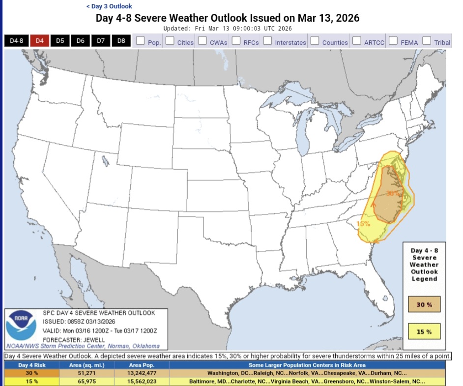
With such a large 30% area already highlighted 4 days out on a forecasted nagatively tilted system coming out of the Mississippi valley while we're already on a bit of a convective heater gets me all hot in the trousers. . That said, the severe outlooks being placed so far east and mediocre surface temps warrant some bust concerns. If this forecast were to verify the main thing I'll be watching on Monday is the proximity and time of convective initiation, low level lapse rates, and moisture return. If we can score some juicy overlapping, there and some of the other parameters hold true, it should be one hell of a day, not far from home. -
Central PA Spring 2026 Discussion/Obs Thread
Yardstickgozinya replied to Voyager's topic in Upstate New York/Pennsylvania
Big potential Monday creeping into southeast and south central Pennsylvania with a negatively tilted system. ...DISCUSSION... Significant severe winds and the potential for a few tornadoes will develop on Monday over parts of the Carolinas and Mid Atlantic. https://www.spc.noaa.gov/products/exper/day4-8/#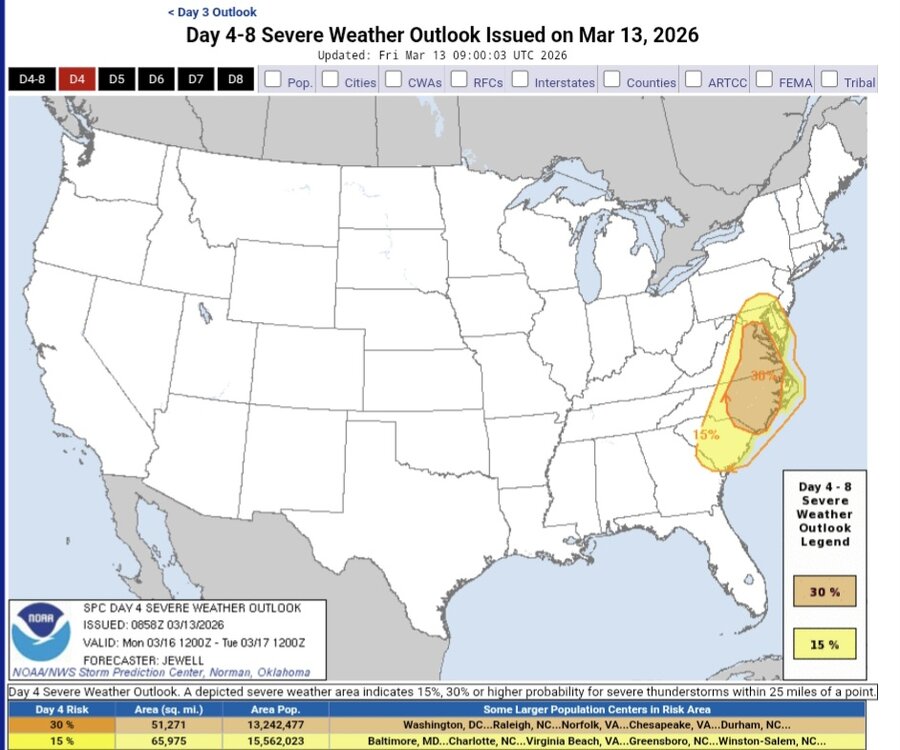
-
Central PA Spring 2026 Discussion/Obs Thread
Yardstickgozinya replied to Voyager's topic in Upstate New York/Pennsylvania
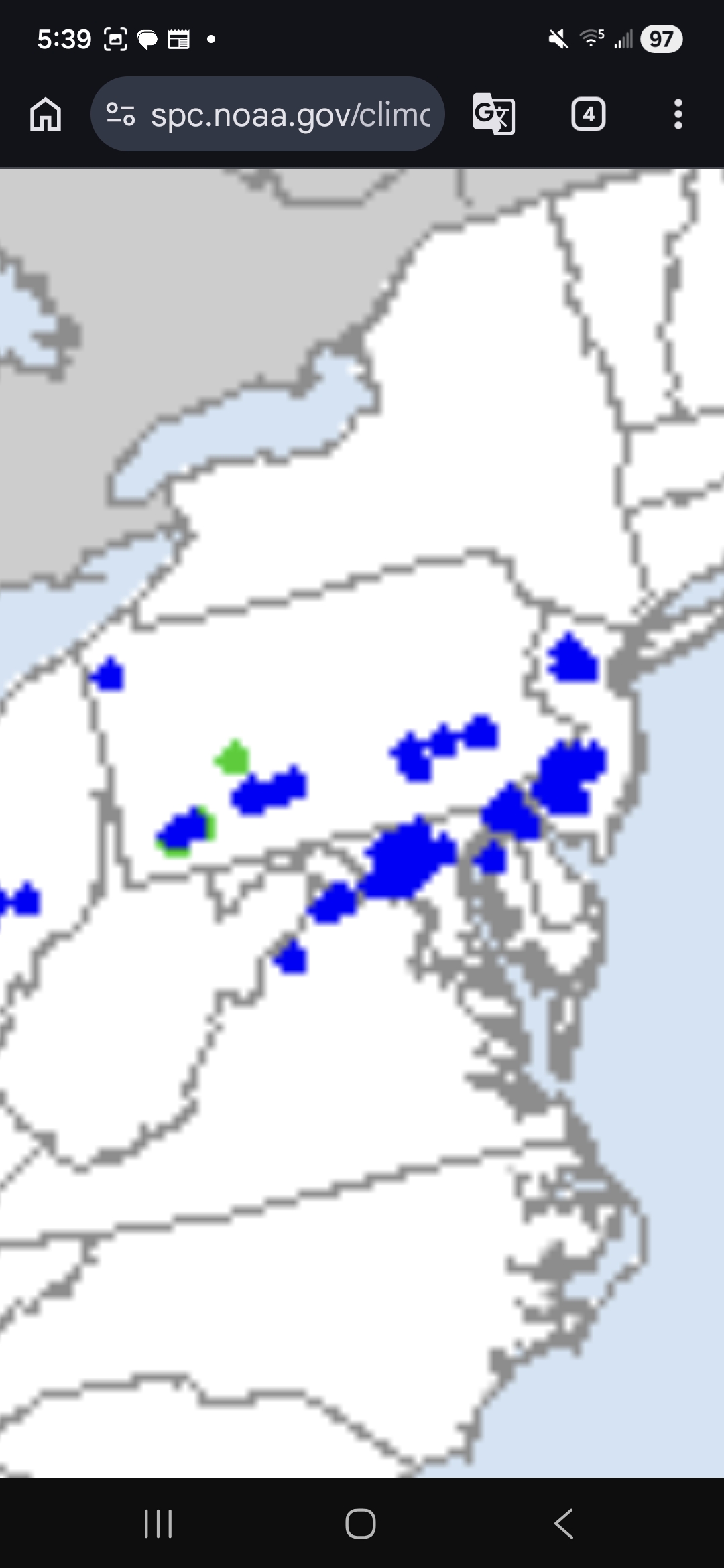
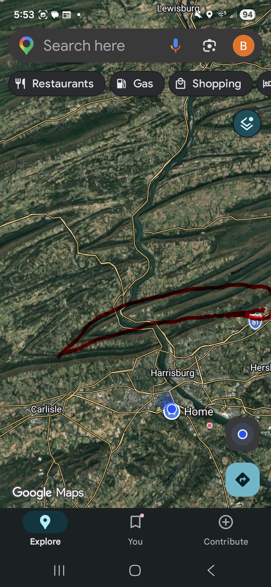
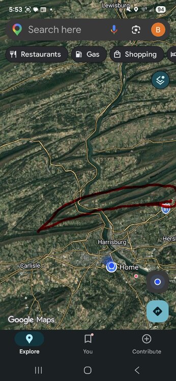
Not even a hail report with yesterday's supercell. That looked to be one of the most intense hail cores I've seen in these parts in a few years. I think the location of this storm during its peak played a big role in the lack of storm reports. It couldn't have taken a better path to absolutely affect nobody. I don't have the circle placed perfectly but it's very close. https://www.spc.noaa.gov/climo/reports/yesterday.html
-
Central PA Spring 2026 Discussion/Obs Thread
Yardstickgozinya replied to Voyager's topic in Upstate New York/Pennsylvania
Hell, you can even see the rfd in the first two pictures ,that's textbook. -
Central PA Spring 2026 Discussion/Obs Thread
Yardstickgozinya replied to Voyager's topic in Upstate New York/Pennsylvania
You can clearly see in the fifth picture that that lowering is the mesocyclone, and not just a shelf cloud. If that thing couldn't get a tornado to the ground what can ? -
Central PA Spring 2026 Discussion/Obs Thread
Yardstickgozinya replied to Voyager's topic in Upstate New York/Pennsylvania
Steady ass rain here this morning with real shity f****** cold and wind's blowing at bullshit speed, with some sideways mist mixed in for extra penetration. -
Central PA Spring 2026 Discussion/Obs Thread
Yardstickgozinya replied to Voyager's topic in Upstate New York/Pennsylvania
I thought maybe this would help some enjoy the step out the door this morning. I want extreme cold and wet,I need warm and dry, but when the hell do I get either. -
Central PA Spring 2026 Discussion/Obs Thread
Yardstickgozinya replied to Voyager's topic in Upstate New York/Pennsylvania
The only power outages I could find up that way that we're listed was by pp&l, and I believe I counted 17. It doesn't mean that there wasn't touchdowns or severe weather,but it looks like it might have been pretty sporadic and not a swath. -
Central PA Spring 2026 Discussion/Obs Thread
Yardstickgozinya replied to Voyager's topic in Upstate New York/Pennsylvania