.jpg.93eb8afe5d1df4d67bc0eeb78d645380.jpg)
.jpg.7cbeb4b469bd18d447fac5868c43a091.jpg)
Yardstickgozinya
-
Posts
1,681 -
Joined
About Yardstickgozinya

- Birthday 02/18/1979
Recent Profile Visitors


-
.thumb.jpg.6a4895b2a43f87359e4e7d04a6fa0d14.jpg)
Central PA Summer 2026 Discussion/Obs Thread
Yardstickgozinya replied to Voyager's topic in Upstate New York/Pennsylvania
-
Central PA Summer 2026 Discussion/Obs Thread
Yardstickgozinya replied to Voyager's topic in Upstate New York/Pennsylvania
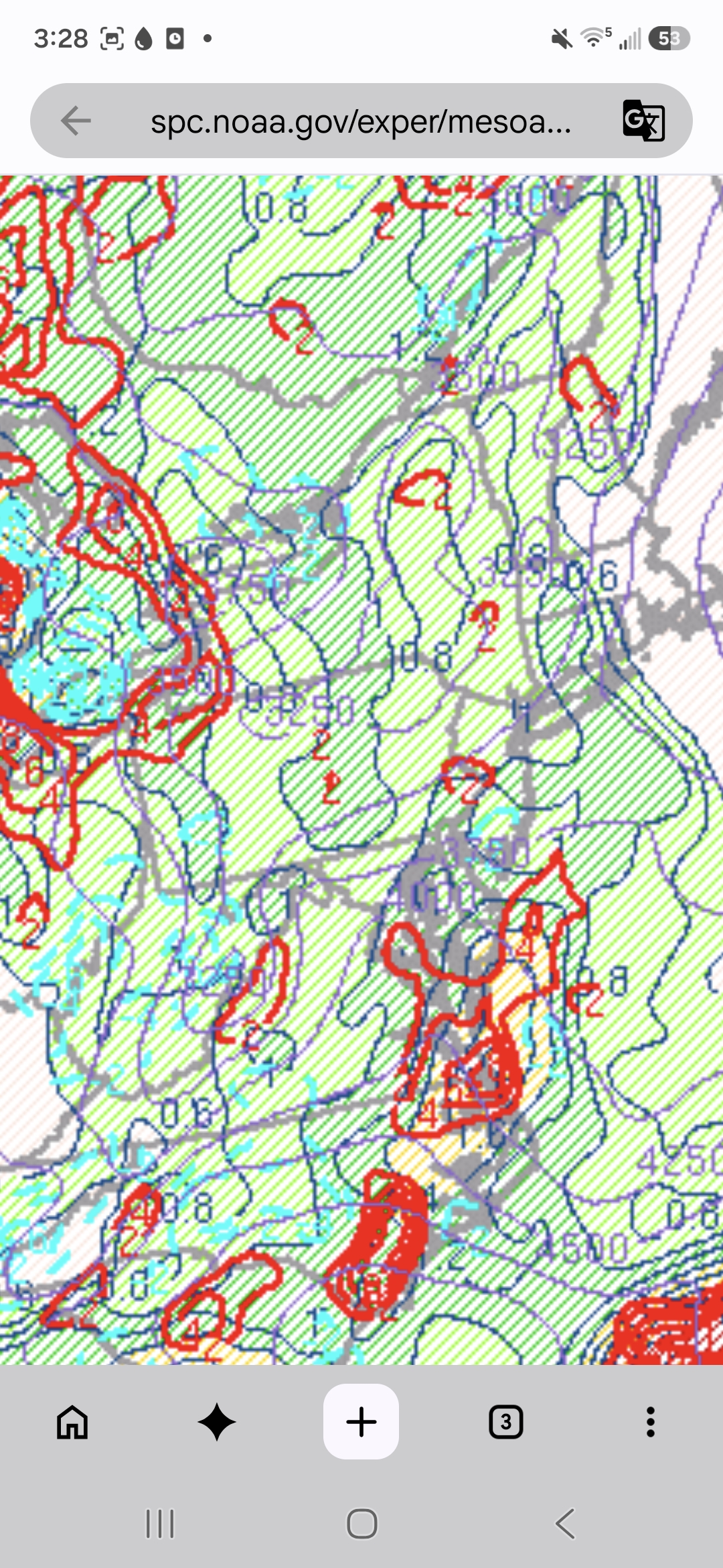
Precipitation potential placement keeps us west of the river in the game for with good potential, if we can get some moisture tap.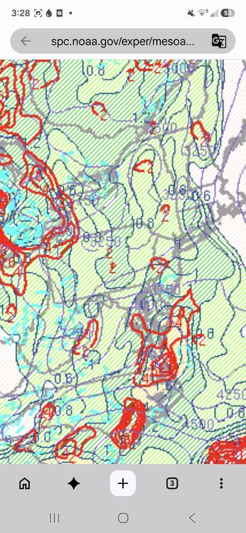
-
Central PA Summer 2026 Discussion/Obs Thread
Yardstickgozinya replied to Voyager's topic in Upstate New York/Pennsylvania
Keynote from national weather service forecast discussion DISCUSSION... Unfortunately, the pattern into midweek does not lend itself to a high confidence forecast given the growing uncertainty details surrounding the evolution upstream convective activity. -
Central PA Summer 2026 Discussion/Obs Thread
Yardstickgozinya replied to Voyager's topic in Upstate New York/Pennsylvania
There's a true saying in the storm chasing and meteorological community thst goes, laps rates over 8, the storms be great. I did not make that up. These storms definitely. have potential to get their energy to the ground with low level lapse rates of 8.5 and increasing.
-
Central PA Summer 2026 Discussion/Obs Thread
Yardstickgozinya replied to Voyager's topic in Upstate New York/Pennsylvania
@TheDreamTraveler I was reading back over posts from the other day and noticed that I made a typo. Shortly after you posted about setting a record low, I posted a comment that said "New records are broken here and not very impressive ". I use a voice app that doesn't always copy my voice properly and sometimes I miss my mistakes.. What I wanted to say was "No new records we're broken here and not very impressive". I was actually referring to the comet thatI made about stretching and making fun of myself.., however I now realize it may not have came across as such. -
Central PA Summer 2026 Discussion/Obs Thread
Yardstickgozinya replied to Voyager's topic in Upstate New York/Pennsylvania
It's all well done but ,for me, personally, b looks the most professional. -
Central PA Summer 2026 Discussion/Obs Thread
Yardstickgozinya replied to Voyager's topic in Upstate New York/Pennsylvania
From nws KEY MESSAGE 2: Turning more humid and unsettled into early next week with the best odds for storms Monday PM through Tuesday PM Shortwave energy diving southeast around the prominent upper high centered over central and southern Plains will help to eventually carve out a closed upper low over the eastern Great Lakes by early next week. Expect a gradual increase in shower and thunderstorm coverage Sunday through Tuesday with peak POPs in the Monday PM-Tuesday PM window based on the latest ensemble guidance. There will likely be some level of severe and/or excessive rain risks to manage that are largely dependent on timing/upstream system evolution at this point. -
Central PA Summer 2026 Discussion/Obs Thread
Yardstickgozinya replied to Voyager's topic in Upstate New York/Pennsylvania
I ment biotic and contagious. -
Central PA Summer 2026 Discussion/Obs Thread
Yardstickgozinya replied to Voyager's topic in Upstate New York/Pennsylvania
@Mount Joy Snowman It is a biotic and infectious tree disease that mainly affects conifers, but it can also spread the hardwoods but apparently it rarely kills hardwoods. Calling in a arborist to be safe, probably wouldn't be a bad idea. -
Central PA Summer 2026 Discussion/Obs Thread
Yardstickgozinya replied to Voyager's topic in Upstate New York/Pennsylvania
I'm really not a tree guy, but i've seen a lot of different things in my landscaping. For my unprofessional viewpoint, the likely culprit looks to be annosus . Annosus Root Rot Courtesy USDA Forest Service, Bugwood.org Hosts Annosus root and butt rot is a commercially important disease of conifers. All southern pines are susceptible, but loblolly and slash pine are most severely affected. Identification Conks are often present in the litter at the base of dead or dying trees or tree stumps, or under root masses of windthrown trees. Conks, when fresh, are tan to brownish on the upper surface and white with tiny pores on the lower surface. They are rubbery and tough to tear. In the southern United States, conks are most common from December through March. Damage Damage from annosus root and butt rot may be scattered throughout a stand or in pockets of dead and dying pine trees called “infection centers.” Mortality is sometimes preceded by thinning and yellowing of the crown; however, some trees simply turn red and die. Trees in various stages of dying or death may suffer windthrow. Infected roots exhibit resin or pitch-soaking, and stringy root decay. Biology Annosus root and butt rot probably enters the stand when fungal spores land on fresh cut stump surfaces. The fungus grows through the remaining root system into nearby live trees via root grafts or contacts. Mortality usually begins 2 to 3 years after thinning and often ceases 5 to 7 years later. Damage increases with the sand content of the soil. Twelve inches (30 mm) or more of sand or sandy loam above a clay subsoil in a soil with good internal drainage is considered a high hazard site for tree mortality. Control Prevention and control strategies for annosus root rot include stump treatment, timing of thinnings, prescribed burns, and the manipulation of planting density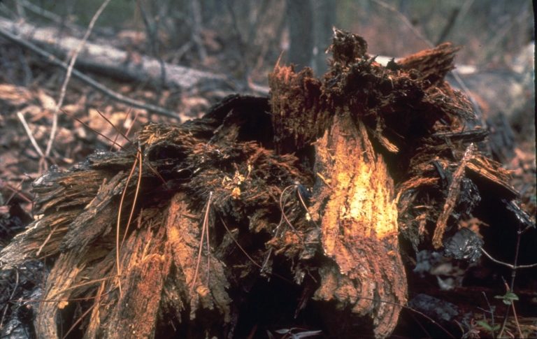
-
Central PA Summer 2026 Discussion/Obs Thread
Yardstickgozinya replied to Voyager's topic in Upstate New York/Pennsylvania
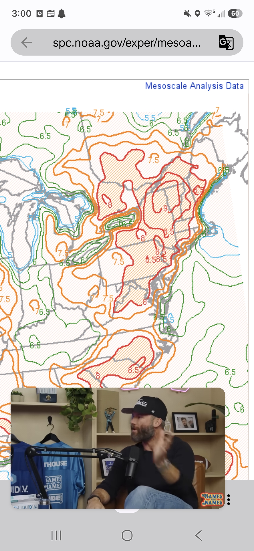
Maybe those rascals over at the SPC are making up stories again, who knows. Day 4-8 Convective Outlook NWS Storm Prediction Center Norman OK 0337 AM CDT Fri Jul 24 2026 Valid 271200Z - 011200Z ...DISCUSSION... ...Day 4/Monday... A prominent upper high will remain centered over the central and southern Plains with a belt of enhanced mid-level flow forecast along the periphery of that feature from the northern Plains into the Great Lakes. Within that flow regime, a short-wave trough is forecast to translate through the Great Lakes in tandem with a surface low and trailing cold front. A hot and moist boundary layer is expected ahead of the front, yielding moderate to strong instability by afternoon. Despite veered low-level winds, strengthening mid/upper-level winds in the exit region of a jet streak will contribute to sufficient vertical shear for organized severe storms across portions of the Great Lakes into the OH Valley Monday afternoon into night. ...Day 5/Tuesday... The Day 4/Monday short-wave trough is forecast to evolve into an upper low across southwest ON and the lower Great Lakes with an associated belt of stronger cyclonic flow developing from the OH Valley into the southern Mid-Atlantic and NC. At the surface, an area of low pressure will develop from the lower Great Lakes into central NY with a trailing cold front advancing through the upper OH Valley, central Appalachians, and Mid-Atlantic. Thunderstorms may be ongoing Tuesday morning along and ahead of the front from the lower Great Lakes and upper OH Valley into the Mid-Atlantic. Stronger heating is anticipated to the south of the early-day storms from the southern Mid-Atlantic into NC, where moderate to potentially strong instability is forecast. The strongest instability will coincide with modestly strong deep-layer shear to support some severe weather threat in those areas Tuesday afternoon and evening. -
Central PA Summer 2026 Discussion/Obs Thread
Yardstickgozinya replied to Voyager's topic in Upstate New York/Pennsylvania
Day 4 clips, western Pa nwhat's slighr risk and Day 5 clips, southeastern Pa with slight risk. -
Central PA Summer 2026 Discussion/Obs Thread
Yardstickgozinya replied to Voyager's topic in Upstate New York/Pennsylvania
New records are broken here and definitely not very impressive. -
Central PA Summer 2026 Discussion/Obs Thread
Yardstickgozinya replied to Voyager's topic in Upstate New York/Pennsylvania
Some mornings you just have to step out of the house and stretch bare ass. -
Central PA Summer 2026 Discussion/Obs Thread
Yardstickgozinya replied to Voyager's topic in Upstate New York/Pennsylvania
I was just curious because some conifers can handle lean more then others. If there was a hump on one side of the root flare, opposing the direction of the lean, then it was destined to fall for wind or over saturation at some point . If the root flares went out nice and straight in all directions and there was no humps ,bumps or rot in the actual central leader then you might want to have an arborist come check your other conifers on your property if you have any.