

Winterweatherlover
-
Posts
1,109 -
Joined
-
Last visited
Content Type
Profiles
Blogs
Forums
American Weather
Media Demo
Store
Gallery
Posts posted by Winterweatherlover
-
-
9 minutes ago, snowman19 said:
When the GFS isn’t suppressed at this range, it’s normally a bad sign. Typically it’s way south and east then trends towards the other models in our big snowstorms. Guess we’ll see
.The 12Z CMC is further SE than the 12z GFS.
-
9 minutes ago, Stormlover74 said:
Rain on the 6th
Precip type doesn't really matter this far out but it's rain to snow verbatim for the city. Also as another poster said would be snow for some of subforum at least, but it's not far off from snow to the coast. I don't want to overanalyze though because the gfs is the only model that even has a storm on 1/6 but my point is we are seeing chances within 10 days and not just non stop torch.
-
GFS with a snow threat 1/6
CMC with a snow threat 1/9
As I said two days ago the pattern doesn't look that horrendous for January after the middle of this week.
-
 2
2
-
-
9 hours ago, TriPol said:
I don’t care how much or how little snow we get this winter…. As long as this never happens again.
Wow urban heating at its finest, what storm was that?
-
 1
1
-
-
Considering it only hit 70 in January 3 times in the 1900s, if it hit 70 twice in three years that would be kind of scary.
-
2
-
-
2 minutes ago, Allsnow said:
Yup. Instead of +20 it will be +5-10
Thats borderline ok for snow chances in NYC in January and def ok for snow chances north and west.
-
34 minutes ago, MJO812 said:
Sucks
Rather have below 0 temps
At this point of life I'd rather live somewhere that never hits 0 or 70. I don't like extreme temps. Guess in an ideal world I should move to San Francisco lol but then they never get snow.
-
1
-
-
9 minutes ago, the_other_guy said:
talk about putting the kibosh on winter …geez
63F. this would be a beautiful day in April.
Its fine, often times these type of extremes lead to big storms so the warmer it is this weekend the more I think next weekend has a chance lol.
-
6 minutes ago, winterwx21 said:
It was always supposed to cool down at the end of next week after the 1 week blowtorch pattern. But the cooldown doesn't look like a big deal. Look at the Euro. The cooldown probably won't even get us all the way down to normal temps. Still a mild pattern with no sign of any major cold.
Not sure if this post was in reference to snow chances or just temps but we don't really major cold to snow chances in January, just close to average.
-
Just now, RedSky said:
60F already had to open the car windows it's a furnace in there
After the extreme cold earlier in the week I'll take it. Rather comfortable than cold and dry at this point of my life. Just hope it doesn't get too warm.
-
3 hours ago, the_other_guy said:
The temperature variances in the city during these warm ups astound me over the last 10 years?
why can’t the city cool off at night during these warm periods? Why is the UHI stronger than it is during any other period? It makes no sense.
Central Park at 48F. Every suburb is 10-15 degrees cooler at 8 am!
Its similar in the summer heatwaves too, the most drastic differences between city and surrounding at night seem to be during the more extreme weather especially warmth.
-
People already canceling winter and yet there are storm threats as soon as next weekend. I honestly still wouldn't expect anything until after mid January but winter isn't over.
-
1
-
-
I'll admit this cold is more fierce than I expected here. It's 9 degrees out right now.
-
1
-
-
6 minutes ago, Brian5671 said:
back roads maybe, but highways and secondary roads will dry out with the traffic
Yea it's not dropping that fast here either, it went from like mid 40s to mid 30s in a couple of hours which is decent, thats nothing compared to the type of drops further inland.
-
1 minute ago, North and West said:
.Thats why I said probably. Anything can happen but the pattern the next 3 weeks looks horrible.
-
Well it was nice to see the 5 minute snow squall, probably the only snow we'll see again until at least Mid January.
-
Mixing with snow now as things wind down. So odd to see the cold air rushing in from south to north.
-
The storm next week being halfway out in the atlantic on the GFS and CMC is probably where we want it at 180 hours out the way the winter is going.
-
4
-
 2
2
-
-
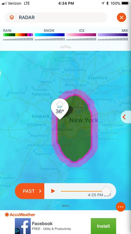
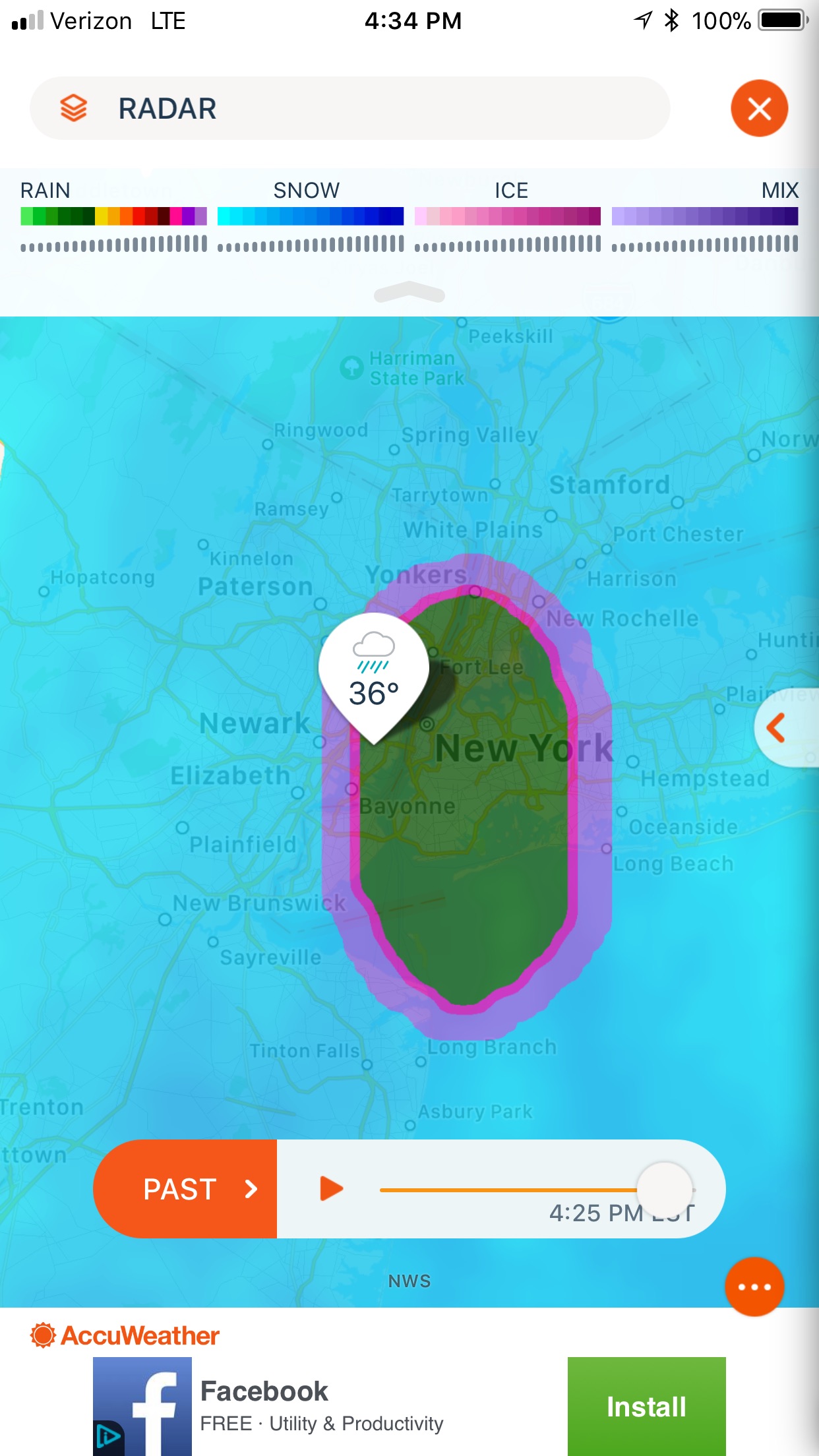
Looks like backend accumulating snow becoming more likely for Sullivan county and the catskills on Friday, some possible mood flakes further southeast of there as well, looks like the further west you are the better chance.
Next week looks interesting on CMC, I know it's only model showing it but thats fine I trust the CMC more than other models.
-
1
-
-
2 minutes ago, winterwx21 said:
Somehow you didn't understand my point? By next wednesday we're starting to warm up, so there would be the threat of it not being a snow event if we get hit. The threat, not that I'm saying that would definitely be the case. At this early point there's no way to know details.
Right now my guess is we won't get hit by anything as most model runs have been showing, but a long way to go. At least it's a little something to watch even though it's a longshot.
I don’t think what most models are showing 7-8 days out means anything. A hit is equally likely to no hit at this point imo.
In terms of precip type very much undetermined but agree with you I don’t think we can just assume it’d be snow.
-
1
-
-
The CMC has actually been creeping SE with backend snow on Friday. It’s kind of getting close for the northern and western parts of the subforum. We’ll see.
-
2
-
-
4 minutes ago, winterwx21 said:
The funny thing is that even though the CMC hits us with the potential wednesday event next week, it warms us up enough that it's mostly sleet and you have to go way NW to see snow accumulations. Obviously at this range a model showing a detail like that doesn't matter very much, but it wouldn't be a surprise if something like that happened since we've really been getting screwed in this December pattern.
I’d take a sleet storm it’s better than rain.
-
1
-
-
54 minutes ago, SnoSki14 said:
Interestingly enough the CMC has some of the flash freeze elements the GFS has. It goes from upper 50s to upper 20s over a 6hr period.
Flash freezes are very rare but so is this system. If you just like interesting weather then Friday could be fun.
I think there will be a big drop quick but it won't be as crazy as some models are hinting. Probably end up in like the mid to upper 20s on the coast.
-
Chicago is now mixing on the storm this week lol can't believe this was at one time out in the atlantic, the long range models are terrible.
-
1
-
January 2023
in New York City Metro
Posted
Its a long shot for sure especially I95 corridor and points southeast.