

MDScienceTeacher
-
Posts
163 -
Joined
-
Last visited
Content Type
Profiles
Blogs
Forums
American Weather
Media Demo
Store
Gallery
Posts posted by MDScienceTeacher
-
-
1 hour ago, CAPE said:
There is always some degree of uncertainty beyond a few days and it grows from there. This is a given.
Right. This is why I have never really understood why someone would trust a 384 hour H5 map any more than they would trust a blizzard being shown during the same time period. I get it, the higher up you go, the longer the wave and the more skillful the long range models get. But 10 days is fantasy land on the surface AND at 500 MBs.
when I am looking at the ensembles, I like to look a the individual members to get an idea about how far out in to the long range I can trust the output that the model is producing. At some point what you will see is significant divergence of the members. If you look at the latest GEFS, the point at which the members start to significantly diverge is at about 192 hours.
Thats tells me that the upper limit of models range is at about 6-8 days. Anything after that the confidence is pretty low.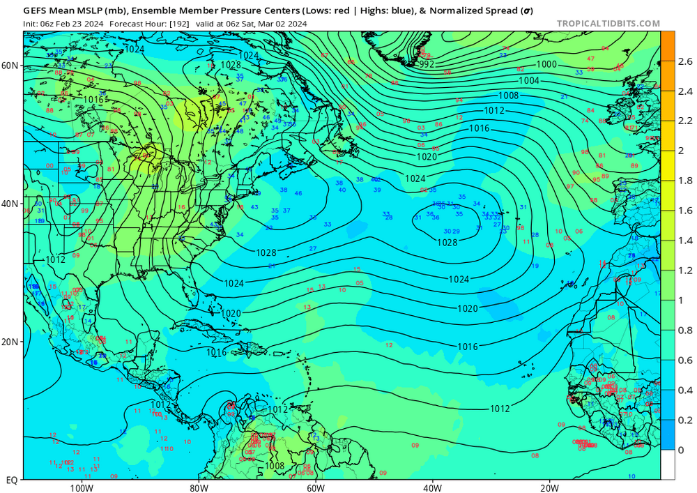
-
 2
2
-
-
1 minute ago, Terpeast said:
Not sure about DCA, but after today IAD has 11.7” on the season.
Edit: DCA at exactly 8.0”
Okay dca is within reach. Dulles will be a struggle. My point is that extended periods of low snowfall totals in our region have occurred before.
here is 1893 to 1898 (Baltimore)
1893-94 0.0 0.0 0.0 0.0 0.2 3.1 1.0 11.7 T 5.0 0.0 0.0 21.0
1894-95 0.0 0.0 0.0 0.0 T 3.0 5.0 9.3 0.6 0.0 0.0 0.0 17.9
1895-96 0.0 0.0 0.0 T T 0.2 1.0 2.8 13.8 T 0.0 0.0 17.8
1896-97 0.0 0.0 0.0 0.0 3.0 3.2 4.7 0.7 T 0.0 0.0 0.0 11.6
1897-98 0.0 0.0 0.0 0.0 T 2.6 5.4 T 2.4 0.1 0.0 0.0 10.5And there are so many more periods like this.
-
1 hour ago, JenkinsJinkies said:
Yeah I’m calling it for the metros, DC busted hard. Above climo is not happening.
How much is dca and Dulles at for the year currently? And how does it compare to average? BWI will likely be over climo.
-
1 hour ago, Bob Chill said:
The most common place for legit polar/arctic air south of the polar regions has been Russia and China. The wrong side.
This is really important to understand if you are a snow lover here in the ma. Sure their is warning.. this is an undisputed fact.. but the earth is still plenty cold for snow and I really feel as thought the pendulum will swing back in our direction soon.
A lot of climate scientists say that the overall impact of AGW will be more frequent and stronger storms. As long as we don’t go completely off the cliff with the warming I feel like this should be a net positive for our snow chances.
We just need to wait for a pattern shift that gets proper arctic air down in to our region. Looking at year to year snow fall amounts for Baltimore, there were many 3-6 year spans with below average snowfall amounts. We are probably just in one of those.
Anyway we are gonna score here once or twice more before the end of winter and probably go over for the seasonal average
-
1
-
-
7 minutes ago, Weather Will said:
It is still a few inches not winter storm warning criteria if it is correct.
What does the gfs say?
-
15 minutes ago, psuhoffman said:
For the record I’m not cliff jumping. I love to analyze this stuff. I’m curious why the CAMs are off on a tangent so close to game time. But I’ve noted they do this sometimes and the radar looks great. But I’m always open minded to all possibilities. Maybe they’re right. Doubt it but I’ve seen weirder things! It’s chips fall time. But I like to analyze all these situations. They are learning experiences. We will have another similar wave scenario to this someday in the future and the outcome here along with the performance of these guidance tools will be used to help me make a better forecast in the future.
Right. I have lurked on the board for over ten years now and swear you guys see shifts that never materialize based off of pre-storm paranoia. I can’t tell you how many time I have seen it. It usually happens during the Virga stage.
The flagship gfs model gave us an increase in snowfall totals at 18z. Stop looking at the rgem and the hrrr and all the other jv models… they are just gonna make you crazy.
Sleep well knowing that tomorrow morning when you wake up it’s gonna be ripping.
-
1
-
-
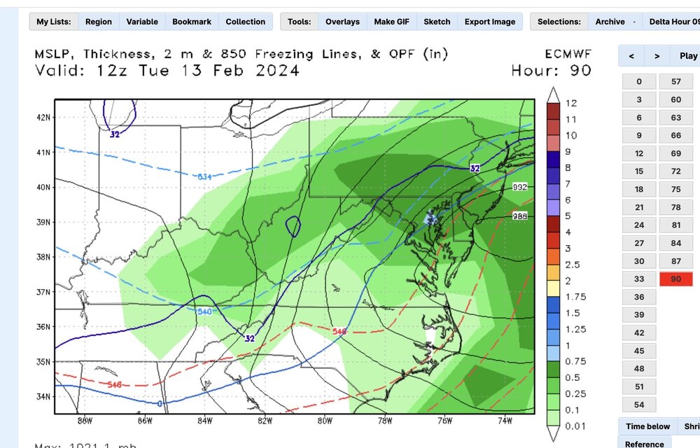
4 hours ago, Ji said:
Qpf going wrong way
What about this:
06Z

00Z
-
2
-
-
2 hours ago, Bob Chill said:
Technically this one isn't a clipper. It a northern stream shortwave from the Pac. We had some of these in 2014 and 2015 when the tpv acted as a block. They can carry much more juice than a clipper diving from the polar regions. Stripes are narrow but pretty juicy. Should be a fun storm
yup.. and it seemed like everyone of those storms trended better for us as we got closer to the onset. A lot of times there was noticeable gulf moisture interaction as the storms tracked in to the midwest.
-
33 minutes ago, Ji said:
Can we get a normal stormIn 2014 we nickel and dimed our way to 50 inches with these types of storms. Most of them over performed by a lot.. one or two giving us a foot. That winter taught me that you dont need a big wound up coastal to score here. Sometimes you just need pressure/ temp gradient and vigorous ns energy diving out of the plains to get a nice normal snow storm.
-
18 minutes ago, T. August said:
Canadian is wetter but not the best precip distribution.
I will be in Rehoboth Beach Delaware for this one.. any chance that 0.35 comes in as all snow there?
-
11 hours ago, SnowenOutThere said:
And it is!*
*post 2016 adjusted expectations
This storm would be 2-4 inches in 1900 too.
-
 1
1
-
-
3 minutes ago, understudyhero said:
Snow is trying to mix in here at haymarket.
Ugghh.. I thought the comma was all snow..
-
4 minutes ago, high risk said:
Goddamnit, y'all. I have literally worked as a RAP/HRRR developer, and I would still use the JMA or NAVGEM before I used the RAP/HRRR system for snow amounts.
")
But the GFS just showed more than the HRRR
-
1 minute ago, Ravens94 said:
GFS south
Yeah another 30 miles too
-
12 minutes ago, NorthArlington101 said:
apparently maybe is the answer to my rhetorical question above?
also came back this far in the thread to give a shoutout to the AI Euro. Looks pretty good right now.
What is the AI Euro?
-
3 hours ago, stormy said:
I will be brief with an answer before deferring to the C.C. Thread.
You obviously misunderstand the premise.
This study suggests that the Glacial-interglacial cycles are not germane anymore because of our CO2 transgressions.
The climate gurus at the U.N. said 5 years ago that it would be more than 300 years before the AMOC shuts down. Now, many scientists are saying with the AMOC at its weakest in 1,600 years, it could shut down completely between 2025 and 2095.
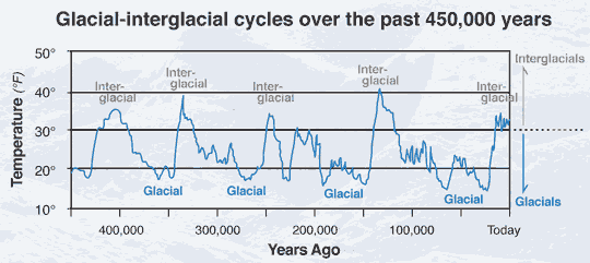
The cycles depicted above are caused by variation in the earths orbit and the resulting impact on solar radiation. That’s an external force that is so much greater than manmade C02 emissions. It will be interesting to see if the current warming has any impact on glacial interglacial cycles but to say that they are not germane any more is foolish. Anything generated by the earth follows the laws of conservation of mass.. this generally limits the level of impact human beings can have on climate. Solar radiation on the other hand will likely trump anything that comes from the earth itself.
-
3
-
-
Just now, stormtracker said:
I don't.
But yeah, I zoomed out and it's def south of 12z
yup.. I could tell the improvement without even comparing it to the previous run. This will probably be one of those deals where rates will dictate the change over and if we get a stronger ULL it will help to mix in the cold air aloft earlier..
Nice to see the euro actually trend in our favor for once.. -
2 minutes ago, stormtracker said:
90:
Do you have a sounding?
-
2 hours ago, Interstate said:
Yeah Flacco. Comeback Player Of The Year!!!
It we cool to see Flacco , Ray and Lamar each on stage tonight!
-
1
-
-
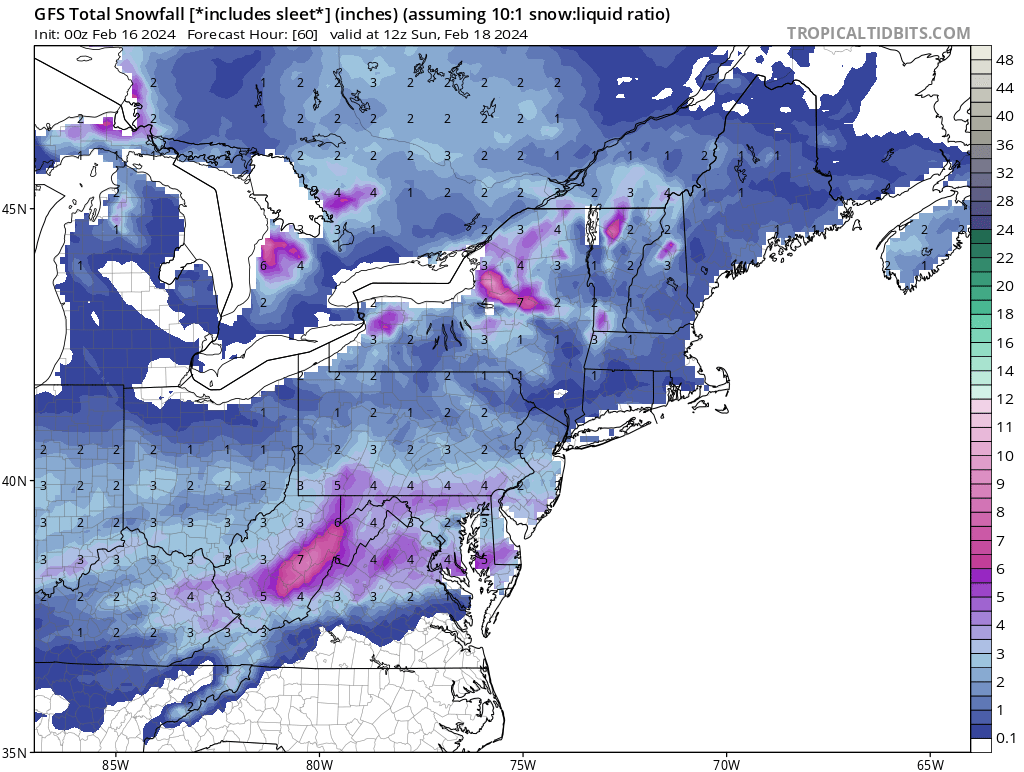
This is Definitely a trend on the euro


-
5 minutes ago, T. August said:
End result for the DC/Baltimore area isn’t much different from 12z, but you are correct. We are moving in the right direction, with light accumulation now showing up near PSU.
If you were in central pa the gfs and euro are pretty locked in. The only difference with the gfs is that the 850s crash a lot earlier and we get in the comma head for a few hours with some heavy/ dynamic snowfall. At this point I am thinking a day out on the slopes at liberty might be a safe bet.
-
1
-
-
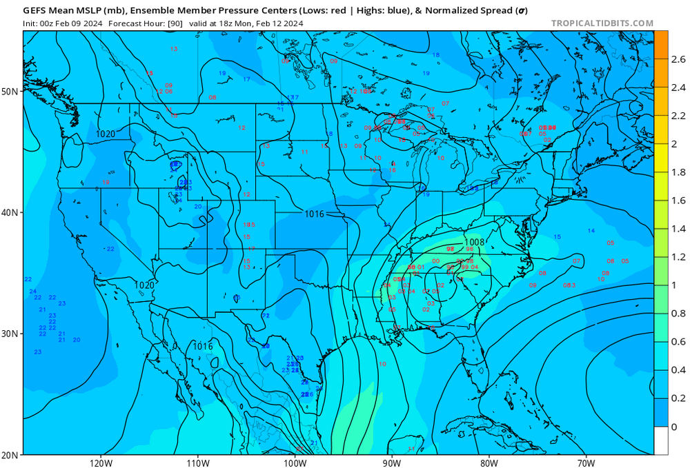
Not sure if anyone has it faster but the low is maybe 50 miles further south at 84 hours
-
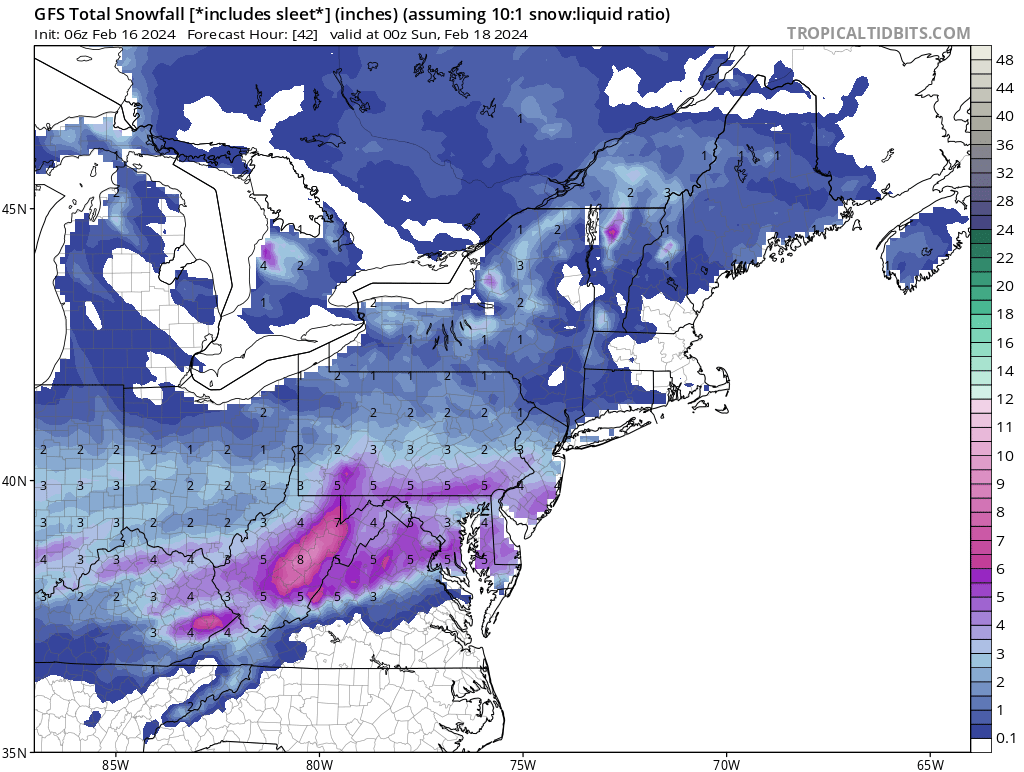
5 hours ago, Weather Will said:
WB 18Z GEFS snow mean trending nicely...

I am pretty sure the vast majority of that is the first storm.
-
3 minutes ago, Stormchaserchuck1 said:
A lot of ensemble variation still on the storm. Some miss it completely to the south.
Usually when there's a bombing low pressure, there is a wider range.
To me it looks more like variation in the timing more then anything else.


Late Feb/March Medium/Long Range Discussion
in Mid Atlantic
Posted
I wouldnt give up so fast. The mid atlantic has had several long periods (7-10 years) of significantly below average snow fall. We are probably just going through one of those now. In terms of warming.. I am with @Bob Chill in thinking the net effect is going to be more severe winters storms but who knows. We are just in one of those long droughts.