

AtlanticWx
-
Posts
604 -
Joined
-
Last visited
Content Type
Profiles
Blogs
Forums
American Weather
Media Demo
Store
Gallery
Posts posted by AtlanticWx
-
-
26.8, holding steady for the past 30 minutes. my low was supposed to be like 29 lmao
-
10 minutes ago, Eskimo Joe said:
Looking more like we're going to swing and miss this year. Our "epic" patterns get stuck in Day 15 - 20 eternally anymore. Next year is a La Nina so we can write that one off as well. Maybe 2025?
i wonder how well this is gonna age in a few weeks lmao
-
24.6/20.8 in germantown right now. the pws near me has to be running cold
-
Just now, WinterWxLuvr said:
This isn’t really cad
how is it not? you have a strong high north of us damming cold air into the mountains here. this is pretty clearly a CAD signature

-
 3
3
-
-
25.7/21.0 rn. my predicted low tonight was like 29-30° lmao
-
all the models im looking at are underdoing the cold at surface level pretty wildly, wouldn't be shocked if we get more wintry weather than we expected tomorrow (not exclusively snow, just like sleet and stuff)
-
1 minute ago, AtlanticWx said:
currently below HRRR's forecasted low for tonight at 29° by about 2 degrees. temperatures are definitely colder than modeled
running 4° below NAM 3K's low too fwiw, cad is def doing its thing tn
-
1
-
-
currently below HRRR's forecasted low for tonight at 29° by about 2 degrees. temperatures are definitely colder than modeled
-
2 minutes ago, Eskimo Joe said:
RAOB data is only incorporated into 00z/12z.
isn't it 00z though?
-
1 minute ago, Eskimo Joe said:
We're 48 hours from the event. Hope it's getting sampled better and we bust colder regionwide. Give everyone 3" - 5".
i do wonder if it got sampled, the confluence is over an area that isn't like data dead anymore
regardless, hopefully we see these changes continue! wishing for a colder outcome for everyone
-
2 minutes ago, NorthArlington101 said:
Agreed - it’s hovering above freezing. I think
once the 850s are shot, it’s plain rain.
3k does the @psuhoffman thing though around 5/6pm and almost pulls the RA/SN into the Belway again. 3k is the best run I’ve seen in the last day-ish that doesn’t involve fleeing westward to see flakessynoptically, 3k nam and nam had colder 850s leading into event as a result of the confluence being handled significantly differently this run at this lead time starting from only 18 hours out
hopefully this is a trend and something we see on all guidance tonight! nam was pretty close for my liking tho honestly
-
4
-
-
this is just a thought but shouldn't the snow stick almost immediately because of how cold the ground is from the two days of pretty cold temperatures along with those 20 degree DPs up until onset? why use snow depth
-
why are operational models so much stronger than ensembles?
-
https://x.com/AtlanticWx/status/1742383118823178693?s=20
At least some positives have come out of climate change -
im confused, this run looked worse before it played out? what makes 18z gfs even better? am i missing some weird vort
-
Just now, ravensrule said:
I would sign on this in a heartbeat. Not sure what all the panic is about.
i think the panic comes from the tight gradient and the fact that we're still so far out
-
1
-
-
2 minutes ago, StormyClearweather said:
the trend for a faster storm is pretty evident here
-
1 minute ago, Terpeast said:
Me too. We have so little wiggle room and we can't afford a slight north jog. 18z gfs just gave us a bit more breathing room
yeah i like seeing all that snow south of the fall line. but euro definitely scares me.
while ik icon is shit, im just glad it shifted south
-
i would like to see south shifts on the ensembles & models into 0z now.
-
1
-
-
3 minutes ago, Ji said:
Does this include the op member?
Sent from my SM-A515U using Tapatalk
nope, op is a bit more NW than the ensembles

-
i like our chances here in the mid atlantic for once, we track
-
1
-
-
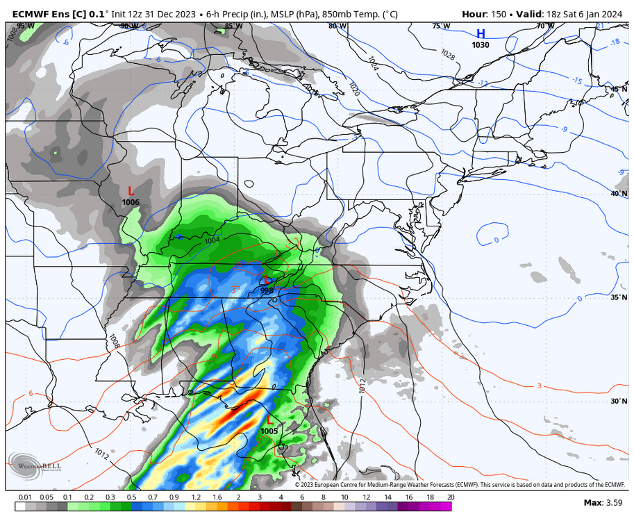
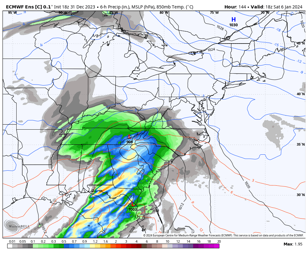
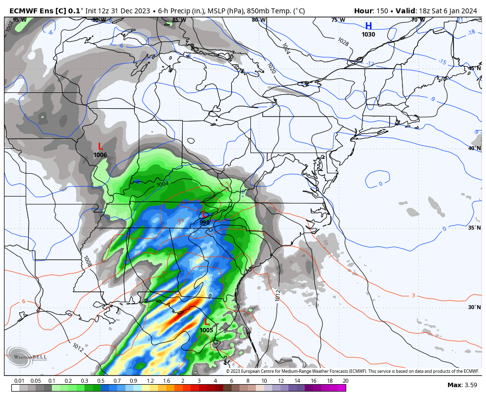
18z eps control looks amazing btw, and it usually shadows the op.
it looks like there's more cold and precip starts quicker. it looks colder than gfs at the very least
18z on top, 12z on bottom

-
11
-
-
feels like we're just setting up for an amazing late winter with all that snow cover we're setting rn
-
3
-
-
Just now, AtlanticWx said:
for fun, i did an analysis of the snow events we've lost due to climate change. the results were pretty surprising, but it wasn't as high as i thought it'd be. still alarming -- we're losing an average of ~1.1 snow events per year.
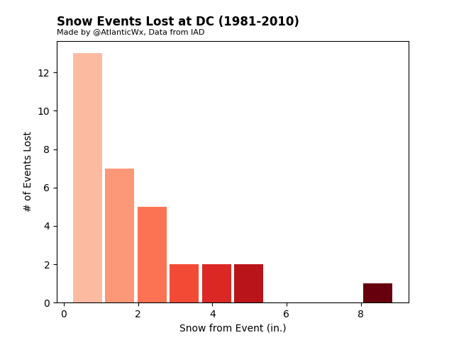
the 8" storm is the late feb 1983 snowstorm btw. it'd be a rainstorm today.
-
 1
1
-

Jan Medium/Long Range Disco 2: Total Obliteration is Coming
in Mid Atlantic
Posted
6z euro has a more consolidated southern vort, and the piece of the TPV that eventually phases with it looks to be digging more. imo, it'd go north & stronger which is good