

AtlanticWx
-
Posts
604 -
Joined
-
Last visited
Content Type
Profiles
Blogs
Forums
American Weather
Media Demo
Store
Gallery
Posts posted by AtlanticWx
-
-
not saying it matters at this range, but the gefs has had a lot of spread the past few runs. looks like it's continously converging to a snowier event and reducing the spread by shifting snower. 00z (had a more - tilt fwiw):

-
 3
3
-
-
2 minutes ago, Weather Will said:
I am posting realistic maps. Let's be real, at best we potentially have a couple of hours of snow trying to stick on soggy ground when it is above freezing...
we know it won't stick though, we wanna see the raw totals fr
-
1
-
-
i think we'll be ripping snow regardless
-
4
-
-
4 minutes ago, CAPE said:
It's literally the same, outside of minor run to run noise.
fair enough, i think i'm j reading too much into it. definitely more of a negative tilt though
-
euro coming in with more of a - tilt, less snow for areas west tho and i'm not sure why

-
2 minutes ago, psuhoffman said:
That’s kinda what inspired me to make that comment.
if we can get one more day of trends like these, maybe we can have model outputs showing 6". just a thought tho, doubt it happens
-

if anyone cares, RAP is better -

gfs better fs
-
2
-
 1
1
-
-
Just now, NorthArlington101 said:
I love having as many models as possible show the snowiest outcome, so it’s annoying to see any model get worse.
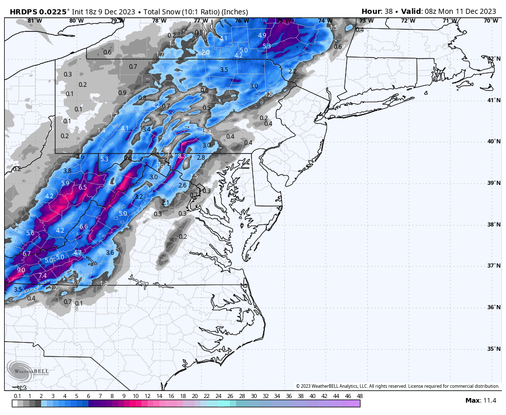
That said, the HDRPs has had some of the most stubborn and worst fails in my recollection. Anyone remember when it gave Baltimore like 36” of snow 2 days out, maybe that was in 2021?i remember it showing like 10" for march 2022 for the longest time
-
new hrdps, less amplified and more of a positive tilt leads to a less snowier solution. gonna have to see what 0z does before seeing if this is a trend

-
nevermind, the whole thing is just slower. looks held back
-
HRDPS looks less amplified at first glance tbh
-
RGEM is more - but still pretty bad around NW of DC bc even tho it's cold enough it's still "raining", says around <1" for NW of DC
-
1 minute ago, NorthArlington101 said:
Can't tell what is high-res nonsense vs. what's real. Will be an interesting test.
Massive differences on the 10:1/Kuchera/snow depth maps, which makes sense. Snow depth maps would verify the WSW you pointed out for the BR, but are pretty stingy almost everywhere else.
honestly gonna be fun to see these rates tho, haven't seen these type of rates modeled in a while
-
4
-
-
Just now, NorthArlington101 said:
Regardless of whether it would actually pan out like that - super cool how it has it as rain up the Potomac to D.C. then following the Anacostia.
yeah it's really elevation dependent this run, it rains IMBY at hr 37 while 5 miles north of me gets puking snow. and that makes sense given im like 50' lower. super cool to see
-
1
-
-

still puking at hr 41.-
2
-
2
-
-
-

yea this is ab to puke snow for those NW of DC -
hrrr looks a lot better so far, more - tilt and more held back. looks similar to nam3k at h32
-
3
-
-
5 minutes ago, 300 square feet said:
Serious question here from someone wanting to learn.
You all remember last winter, I think it was near the end of winter, there was a strong cold front moving through and all the models were calling for anafrontal snow? It went from a prediction of nothing to several inches even in the metros shortly before the event, and we ended up getting nothing.
Is there something about this setup that’s different? Growing up in this area, I know how difficult it is for us to get anafrontal snow, and I’m trying not to get my hopes up.
i was wondering this too but after looking into it further, that event was just synoptically different as a whole. we had a GL low that brought a cold front down here followed by some gusty flurries. I think that event was farfetched to begin with and we were j desperate because there was no trailing low or trough digging in the south.
this event, meanwhile, is caused by a trough digging in the south and turning negative rapidly bringing cold for the last few hours of precipitation. definitely a more promising event where we see a coastal low spawn and bring back moisture into our area for a few hours of flakes or even accumulating snow. def a more promising setup compared to most anafrontals.-
3
-
 2
2
-
-
12 minutes ago, jayyy said:
I’ll take my 1-2” of paste after crashing temps and run with it. Anything more would be an absolute treat.
Man, it’s really nice to track something for a change. Even if it’s just a small appetizer.it's honestly a bonus event too, i wasn't expecting anything till new years
-
4
-
-
the deformation band is back on nam3k, some lucky ppl in moco could see a few sloppy inches w nam3k's depiction verbatim, stalling band for like 3-4 hours
-
1
-
-
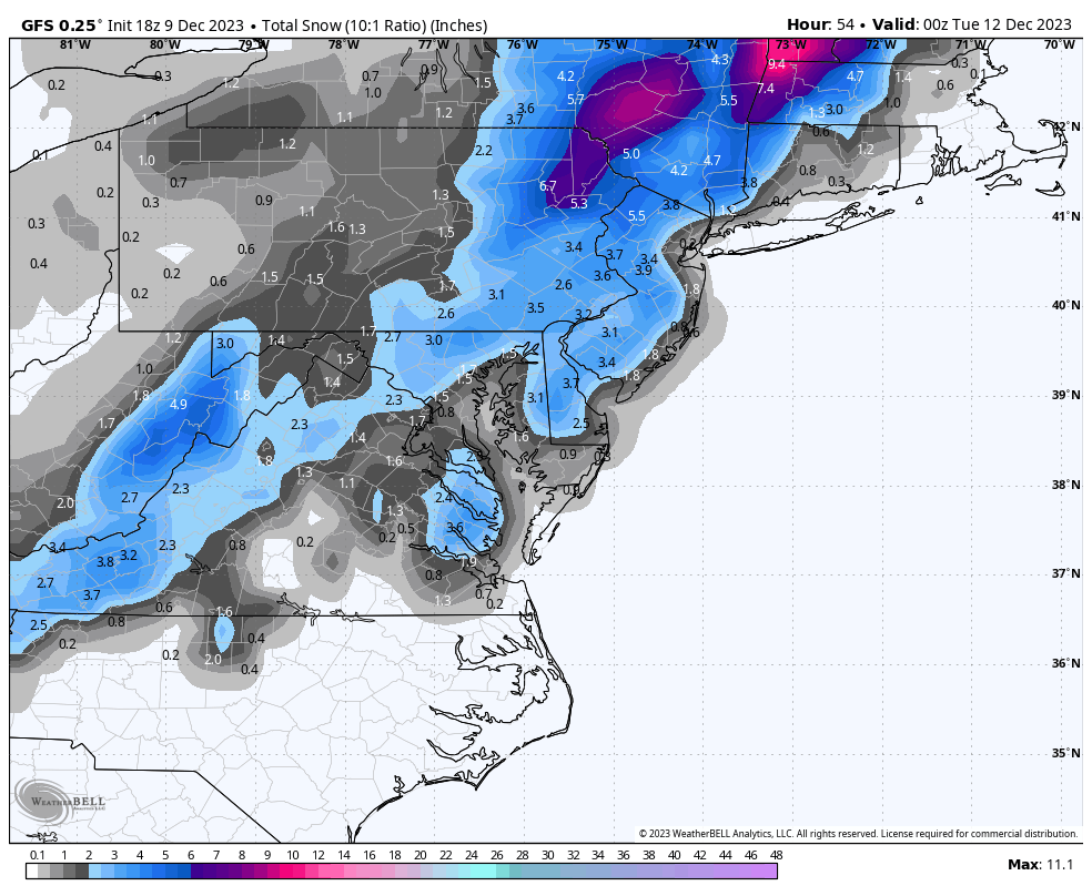
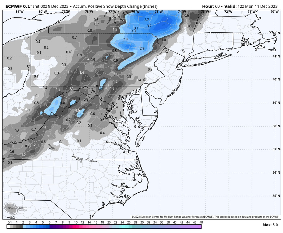 uptick again (10:1 is 2-3" area wide)
-
4
-
-
don't wanna jinx it but encouraging 0z suite so far. euro was already bullish so i wanna see how much more bullish it can get and if the NAM holds tmr
-
1
-


12/10-11 Disco / Obs - Rain/Snow/Wind Event
in Mid Atlantic
Posted
i guess there's still spread, 90th percentile shows 7" with snow still coming down lmao
