

Stormchaserchuck1
-
Posts
4,687 -
Joined
-
Last visited
Content Type
Profiles
Blogs
Forums
American Weather
Media Demo
Store
Gallery
Everything posted by Stormchaserchuck1
-

The Weekend Rule? Saturday 2/17 - The Icon Storm
Stormchaserchuck1 replied to DDweatherman's topic in Mid Atlantic
Yeah, I'll end up with ~1.5" at 467'. -
Shouldn't be attacked for disagreeing that it's going to snow a lot though.. this isn't a kiddie board
-
I guess my schtick is that I don't even read the NWS..
-
The Weekend Rule? Saturday 2/17 - The Icon Storm
Stormchaserchuck1 replied to DDweatherman's topic in Mid Atlantic
It's ok, light to moderate snow here, I can always tell when there is warm air around because rates are not that heavy. Roads and sidewalks are not freezing. -
The Weekend Rule? Saturday 2/17 - The Icon Storm
Stormchaserchuck1 replied to DDweatherman's topic in Mid Atlantic
No more defenses about quality of NOAA maps I'm just trying to teach what I have found are the best ways. -
The Weekend Rule? Saturday 2/17 - The Icon Storm
Stormchaserchuck1 replied to DDweatherman's topic in Mid Atlantic
just saying.. the depth charts have hit it 5/6 times this Winter. -
The Weekend Rule? Saturday 2/17 - The Icon Storm
Stormchaserchuck1 replied to DDweatherman's topic in Mid Atlantic
Do you think the 0z GFS shows like 5-6"? -
The Weekend Rule? Saturday 2/17 - The Icon Storm
Stormchaserchuck1 replied to DDweatherman's topic in Mid Atlantic
Flurries have begun! -
The Weekend Rule? Saturday 2/17 - The Icon Storm
Stormchaserchuck1 replied to DDweatherman's topic in Mid Atlantic
Still nothing here.. all virga so far. Enjoy your 1-2" Winter Storm Warning north of the cities.. the radar is drying up west of Cumberland. I think it was an easy call.. models never had over 4". -
The Weekend Rule? Saturday 2/17 - The Icon Storm
Stormchaserchuck1 replied to DDweatherman's topic in Mid Atlantic
Radar lightening up in WV.. https://radar.weather.gov/station/KRLX/standard -
The Weekend Rule? Saturday 2/17 - The Icon Storm
Stormchaserchuck1 replied to DDweatherman's topic in Mid Atlantic
See that dryslot west of DC around the VA/WV border? -
The Weekend Rule? Saturday 2/17 - The Icon Storm
Stormchaserchuck1 replied to DDweatherman's topic in Mid Atlantic
Big bust potential.. 1z and 2z models dried up a little further, have a lot of the precip getting stuck in the mountains.. 1-2" in the lower elevations north of I-95. Will be interesting to see what happens! -
The Weekend Rule? Saturday 2/17 - The Icon Storm
Stormchaserchuck1 replied to DDweatherman's topic in Mid Atlantic
I'm down to 35F. There seems to be a heat island both in Baltimore and DC. https://ibb.co/M20dcQj -
El Nino 2023-2024
Stormchaserchuck1 replied to George001's topic in Weather Forecasting and Discussion
Especially because of the uptick in global SSTs in general, I always thought 0.2-3 should be subtracted to make it more even with everything. The precipitable water though.. It's #1 of all the years/Strong Nino's since 1948, beating #2 (15-16) by a good 20%. In pre-satellite data, some people use precipitable water to assess ENSO event strengths. -
The Weekend Rule? Saturday 2/17 - The Icon Storm
Stormchaserchuck1 replied to DDweatherman's topic in Mid Atlantic
They are drying up, but you guys are acting like they showed 5-10" a few days ago. -
The Weekend Rule? Saturday 2/17 - The Icon Storm
Stormchaserchuck1 replied to DDweatherman's topic in Mid Atlantic
2nd personal attack by a top poster on this board for discussing science. lol New Hrr has 1-2" area wide, although looking at radar that may be a little dry.. 2-4" may still be in play up north. -
The Weekend Rule? Saturday 2/17 - The Icon Storm
Stormchaserchuck1 replied to DDweatherman's topic in Mid Atlantic
2 things. 1) They aren't really drying up right now. They haven't showed more than 4" across the area for the event the whole way along.. It's only suppose to snow moderately for 3-4 hours. that's why I'm like, why is the NWS predicting 5-8"? The radar and ground elements must be awesome. 2) Last storm they dried up last minute, and it verified. I know in the higher elevations you had like 6", but where I am I went from 4-6" on models to 1-2", and ended up with a dusting.. the whole area less than 500-1000ft experienced the same thing. That's why in these marginal temp situations the 1:10 Kuchera maps are especially wrong.. the snow fell very wet and light because warmer temps went into some upper levels of the atmosphere. I'm at 39F and it will probably drop down to 31-33, but for 10:1 results you usually need to be in the 20s. -
The Weekend Rule? Saturday 2/17 - The Icon Storm
Stormchaserchuck1 replied to DDweatherman's topic in Mid Atlantic
Even the global models do not have more than 2-4".. I guess the radar is more impressive than that? -
The Weekend Rule? Saturday 2/17 - The Icon Storm
Stormchaserchuck1 replied to DDweatherman's topic in Mid Atlantic
22z RAP gives DC <1" of accumulating snow.. it will be interesting to see if the NWS forecasts of 4-8" across the area verify.. models have not been showing that. -
The Weekend Rule? Saturday 2/17 - The Icon Storm
Stormchaserchuck1 replied to DDweatherman's topic in Mid Atlantic
Temps don't support those ratios. Here's what the GFS shows -
It looks like they to the west are pretty warm https://ibb.co/kKkcPyn
-
I'm at 38F, and there's a good amount of precip moving in from the West. Is any of that snow?
-
Late Feb/March Medium/Long Range Discussion
Stormchaserchuck1 replied to WinterWxLuvr's topic in Mid Atlantic
It may warm up quickly after the 24th. This is an awful Pacific pattern if you like cold. ENSO subsurface currently supports this 500mb progression. https://ibb.co/HNN0rCG -
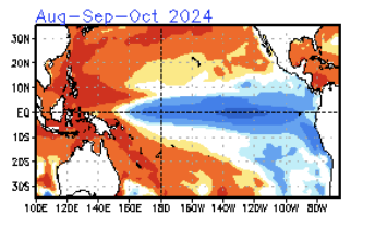
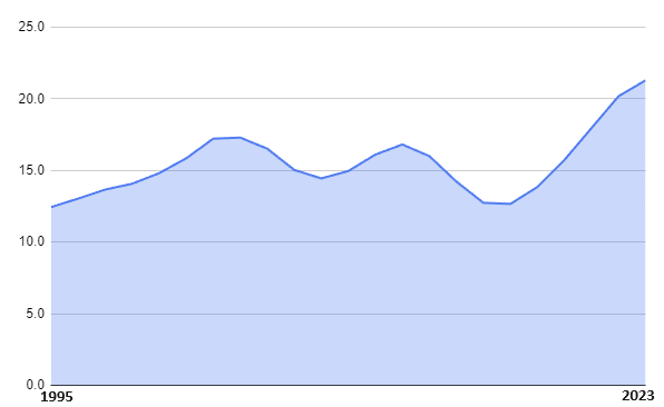
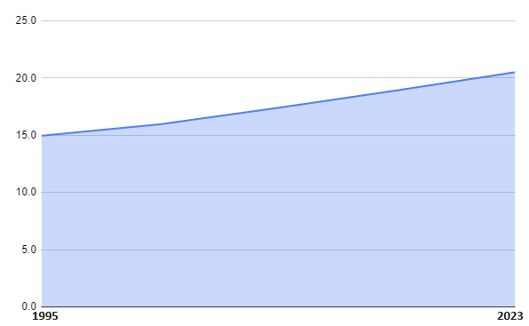
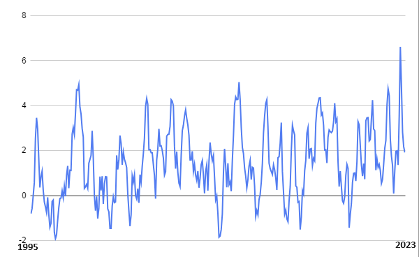
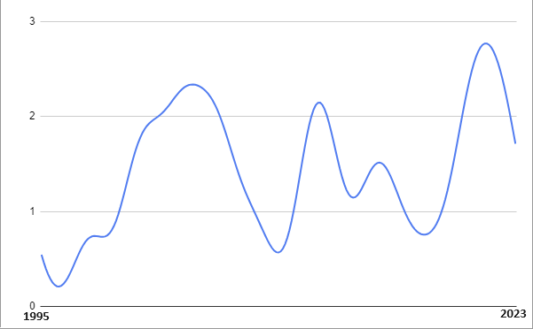
This should be an active season. The NOAA has issued a La Nina watch. https://www.cpc.ncep.noaa.gov/products/analysis_monitoring/enso_advisory/ensodisc.shtml That gives 55% of La Nina conditions developing by the Summer. ENSO subsurface often precedes surface conditions, and can indicate developing ENSO events. Latest TAO/Triton maps have an ENSO subsurface cold anomalies that are -3c in the central-region, which supports La Nina development. Here is a time sensitive map: January IRI models have a La Nina developing by the Hurricane Season: https://iri.columbia.edu/our-expertise/climate/forecasts/enso/current/?enso_tab=enso-sst_table https://ibb.co/LhF2NYx Here is a climate model showing Strong La Nina development In 1995, the AMO (Atlantic Multi-decadal Oscillation) index switched to positive, and since then it's been rising/still hasn't peaked. Atlantic Hurricane season activity is strongly correlated to the AMO, and Atlantic Hurricane season activity has also been in an upward incline since the 1995 AMO switch. Here is a smoothed graph of number of Tropical Storms by year: Since 1995, we have averaged the following number of storms per year in various ENSO states: El Nino (8 years): 12.5 TS, 5.4 Hurr, 2.5 MH Neutral (10 years): 16.4 TS, 8.2 Hurr, 3.8 MH La Nina (10 years): 17.9 TS, 9.2 Hurr, 4.2 MH Here is a smoothed graph of average number of La Nina Named Storms per year, since 1995: In September 2022, the AMO peaked at an all time high of +0.662, and is still rising/in an inclining phase. I plotted monthly AMO numbers, up until the CPC last updated the dataset, which was January 2023: If you smooth out the index, it looks like a very clear rising phase is still underway: The Atlantic activity has been especially strong lately: - 3 of the last 4 years have had 20+ Named Storms - The average in the last 4 years is 21.5 Named Storms/year - 7 of the last 8 years have had 7+ Hurricanes - The average is 8.4 Hurricanes/year for the last 8 years I believe the PDO phase, where we are at a peak of -PDO cycle, with values only seen before in the mid-1950s, also favors greater than average Atlantic Hurricane activity. For having a Strong El Nino in the past year, the PDO didn't moderate that much. It's still deeply negative: Since 1995, PDO <-1 for Aug-Sept-Oct (15 years) averages 17.1 TS, 8.3 Hurr, 3.6 MH. Since 1995, PDO >-1 for Aug-Sept-Oct (14 years) averages 12.0 TS, 6.1 Hurr, 3.1 MH. Never too early to start discussing! Thoughts?
.png.6ae779e27d4180c454bb8c97fb107415.png)
-
Didn't we get -45F in Montana in January? The wind chill at the Chiefs game was -24F.


