RU848789
-
Posts
4,002 -
Joined
-
Last visited
Content Type
Profiles
Blogs
Forums
American Weather
Media Demo
Store
Gallery
Everything posted by RU848789
-
Just woke up and took a nice walk outside in the gorgeous silence of a fresh snowfall. As of 5:30 am, we're up to 2.6", which is 1.2" the past 3 hours or 0.4" per hour and the radar loop from the last 3 hours looks like the snow was pretty steady for most of NNJ/CNJ (N of 195) and all of NYC and it still looks pretty good for another hour or two. Temp is down to 31F and all paved surfaces are covered with about 1" of snow. Huge overperformer - think we'll make it to 3" as the latest HRRR still shows another 1/2-3/4" for most of NNJ/CNJ (especially the eastern half as the back edge of precip approaches) - as I said when they posted the advisories last evening, Middlesex County should've been part of it.
-
Best hour of the storm with 0.3" bringing us to 1.4" as of 1:30 am and with temps steady at 32F, we're finally seeing some accumulation on paved surfaces (just a coating so far, but assuming we get another 1/2"-1", much of that should end up on the paved surfaces now (once the snow has a foothold, subsequent snow falls on 32F snow, not slightly warmer cement, and accumulates readily). Nap time for the next ~3 hours; hopefully the HRRR/RAP hi-res models, which have been doing well continue to do so, as they show another 1" for much of CNJ and 1"+ for all of NENJ/NYC from now through 7-8 am.
-
I asked in the Philly thread and 3 hours ago there was 1/2-1" in NW parts of the city, but less near center city and the airport, which is the warmest spot in Philly; the PNS lists 1.5" in Bustleton in the far NE of the city and a friend in CC has about 1". Another poster in my hometown of Turnersville about 10 miles SSE of CC reported 1.4". Lots of 1.5-3" amounts in Sussex/Warren/Morris/Hunterdon/Somerset.
-
Looks like Manhattan, Brooklyn, Queens and SI are finally getting some accumulating snow, at least on colder surfaces just looking at the radar.
-
So, as of 12:30 am, we're up to 1.1" with 0.2" falling the past hour; temp still at 32F and with wet paved surfaces, it'll still take more intensity (to overcome the melting from liquid water probably at about 33F) or a drop to 31F to get some accumulation on paved surfaces.
-
So, as of 12:30 am, we're up to 1.1" with 0.2" falling the past hour; temp still at 32F and with wet paved surfaces, it'll still take more intensity (to overcome the melting from liquid water probably at about 33F) or a drop to 31F to get some accumulation on paved surfaces.
-
Less intensity the last hour, so as of 11:30 pm we're now at about 0.9" with the temp finally down to 32F, so we should start seeing some accumulation on paved surfaces. Latest HRRR still showing another 1-2" overnight for most of CNJ/NNJ/NYC, so 2" is easily within reach here and for most, with some areas in the Lehigh Valley, NWNJ, Bucks, Montco, the Poconos, etc. already having reached 2"+.
-
And another 3/8" this past hour giving up 3/4" so far. Should definitely make my 1.25" prediction and will hopefully get to 2" if the models are correct. Light to moderate snow continues at 33F, just warm enough to have minimal accumulations on paved surfaces, but it's forecast to drop to 32F by midnight for most of CNJ, with some more snow to come, so secondary/untreated roads and sidewalks/driveways could get slippery (but no major driving impacts expected outside of areas that get 3" or more well NW of 95).
-
And another 3/8" this past hour giving up 3/4" so far. Should definitely make my 1.25" prediction and will hopefully get to 2" if the models are correct. Light to moderate snow continues at 33F, just warm enough to have minimal accumulations on paved surfaces, but it's forecast to drop to 32F by midnight for most of CNJ, with some more snow to come, so secondary/untreated roads and sidewalks/driveways could get slippery.
-
Probably could've included Middlesex; here's the text from the WWA... URGENT - WINTER WEATHER MESSAGENational Weather Service Mount Holly NJ1007 PM EST Fri Dec 20 2024Sussex-Warren-Morris-Hunterdon-Somerset-Mercer-Lehigh-Northampton-Upper Bucks-Lower Bucks-Including the cities of Allentown, Trenton, Easton, Perkasie,Doylestown, Morrisville, Flemington, Newton, Morristown,Washington, Somerville, Bethlehem, and Chalfont1007 PM EST Fri Dec 20 2024...WINTER WEATHER ADVISORY IN EFFECT UNTIL 7 AM EST SATURDAY...* WHAT...Snow. Total snow accumulations of 2 to 4 inches.* WHERE...Portions of central, northern, and northwest New Jerseyand east central and southeast Pennsylvania.* WHEN...Until 7 AM EST Saturday.* IMPACTS...Plan on slippery road conditions.
-
NWS-Philly just issued advisories for most of CNJ/NNJ/NEPA for 2-4" of total snowfall (but not Middlesex, lol). Oops, dupe post; see above...
-
NWS-Philly just issued advisories for most of CNJ/NNJ/NEPA for 2-4" of total snowfall (but not Middlesex, lol).URGENT - WINTER WEATHER MESSAGENational Weather Service Mount Holly NJ1007 PM EST Fri Dec 20 2024Sussex-Warren-Morris-Hunterdon-Somerset-Mercer-Lehigh-Northampton-Upper Bucks-Lower Bucks-Including the cities of Allentown, Trenton, Easton, Perkasie,Doylestown, Morrisville, Flemington, Newton, Morristown,Washington, Somerville, Bethlehem, and Chalfont1007 PM EST Fri Dec 20 2024...WINTER WEATHER ADVISORY IN EFFECT UNTIL 7 AM EST SATURDAY...* WHAT...Snow. Total snow accumulations of 2 to 4 inches.* WHERE...Portions of central, northern, and northwest New Jerseyand east central and southeast Pennsylvania.* WHEN...Until 7 AM EST Saturday.* IMPACTS...Plan on slippery road conditions.
-
thanks!
-
It's not quite that simple. In a perfect world, if one could truly run the engine "dry" of all fuel, that would be best, as no fuel means no oxidation of residual fuel by the O2 in air, which is what leads to polymerization of fuel, i.e., "gunk." The problem with that is it's really hard to ensure the engine and carburetor are truly devoid of fuel by running until the engine stops and if there is any residual fuel in the carburetor, gunk can still form in a more concentrated state. That's why many engine manufacturers recommend keeping the engine as close to full as possible with fresh fuel (so very little air/O2 are present) and adding a fuel stabilizer to it to reduce oxidation/polymerization forming gunk. I know the link below is from an additive company which could be self serving, but with 40+ years in the chemical industry and being in charge of hundreds of gas powered engines of all types in managing factories, I do have some specific knowledge here. https://www.sta-bil.com.au/news/a-perspective-on-running-equipment-dry-before-storage-2#:~:text=The reason manufacturers recommend running,in the engine during storage.
-
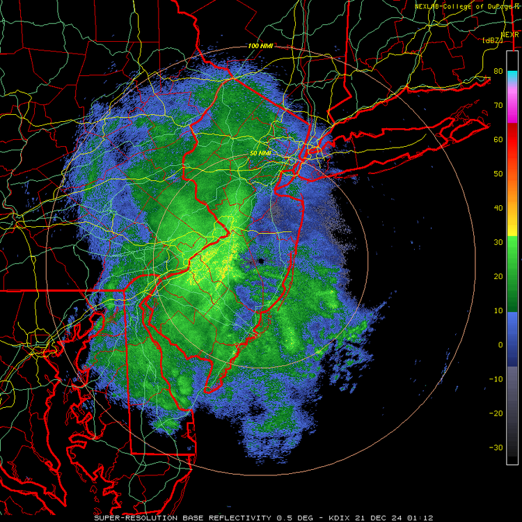
If the 01Z HRRR (below) and RAP and the 0Z NAM (below) are right, we're going to get another 1-2" in most of CNJ/NNJ/NYC and even down to Philly and parts of SNJ.
-
Ok, kids, game on! We got 3/8" in the last hour for an hourly rate of - wait for it - 3/8" per hour, lol. Snowing moderately at 33F and accumulating everywhere except on paved surfaces - nice dendrites, so the snow growth aloft must be nice in the dendritic growth zone. Radar looks good for awhile, so 1-2" is certainly in reach. Let's see how it goes. My wife and I just went for a very nice walk outside - it's just gorgeous out there!
-
This might count as rubbing it in, lol.
-
Any reports from Philly, proper, yet? Haven't noticed any in this thread. Thanks.
-
Any snowfall reports from Philly? Heard it's snowing hard, as per the radar, but no idea if it's accumulating (a friend in center city said not on the streets yet, but that's not a surprise).
-
Looks like you will be right - just hoping, selfishly, that the Edison area at least gets in on some of it - starting to get a nice batch here with light to moderate snow again for the first time in a couple of hours and starting to accumulate at 33F.
-
Incoming! For 95 corridor in CNJ...