

vortmax
-
Posts
4,641 -
Joined
-
Last visited
Content Type
Profiles
Blogs
Forums
American Weather
Media Demo
Store
Gallery
Posts posted by vortmax
-
-
This is a cool loop showing the LE moving with wind veering NE...
https://weather.cod.edu/satrad/nexrad/index.php?type=BUF-N0Q-1-200
You can see the band on radar hitting the west end of the lake...somewhere near Hamilton, Ont.
-
Just now, mattny88 said:
great thanks vortmax..my parents live in ontario right off lincoln road...turn left at light at tractor supply off 104..about 2 miles south of 104 on lincoln..so theyve been giving me updates..yea man wayne county in specific looks to be the absolute jackpot with this storm with the lake enhancement....reminds me of valentines day storm of 2007 even though i wasnt living here at that time but from the locals
That's pretty close to me. I'm on Furnace about 2 miles N of 104.
-
Just now, mattny88 said:
lets get some more model snow maps going on in this forum shall we....hows the snow spotters and reporters looking out in Rochester guys??
I'm not officially measuring, but we are approaching 3" since 7am.
-
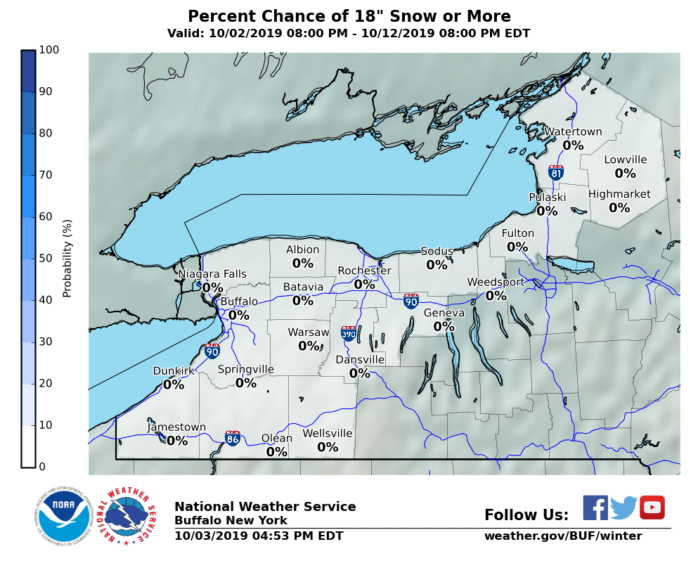
50% probs for 18+, don't see this often:
-
Are there any radar/sat views that can show the lake streamers enhancing the synoptic? Just curious.
Heavier bands starting to show up:

-
5 minutes ago, CNY-WXFREAK said:
I'm posting this in here because its relevant to our situation in either WNY-CNY but can be even more intense across our area as the system will be strongest as it passes by just to our S&E!
Areas affected...Northeast Indiana...northwest Ohio and southwest
   Michigan

   Concerning...Heavy snow

   Valid 191609Z - 191915Z

   SUMMARY...Moderate to occasionally heavy snow will continue into the
   afternoon. Snowfall rates of 1 to 1.5 inches per hour are expected.

   DISCUSSION...A large precipitation shield has developed north of a
   deepening surface cyclone moving into the southern Ohio Valley.
   North of the rain/snow line, currently located just south of Marion,
   Indiana to near Delaware, Ohio, moderate snowfall has developed. A
   band of enhanced snowfall rates has developed from Rochester,
   Indiana to near Ann Arbor, MI. The location of this band matches 12Z
   NAM cross sections which had an area of negative saturated
   equivalent potential vorticity (EPV) above the low-level
   frontogenesis forcing. This area of conditional symmetric
   instability(CSI) is expected to wane by 18Z and then redevelop
   between 18Z and 21Z across northwest Ohio. Snowfall rates beneath
   these heavier bands will likely exceed 1 inch per hour with snowfall
   rates above 1.5 inches per hour possible. Outside of these stronger
   bands, snowfall rates will be around 0.5 to 1 inch per hour.
CSI!
-
2 minutes ago, tim123 said:
Gfs v3 now has low at 986 passing west of Boston.
Earlier phase!
-
5 minutes ago, DeltaT13 said:
Just took the dog to the vet up in Greece. Almost two new inches on the ground and snowing heavily. The roads are atrocious already because temps in the mid teens are negating any effect from salt while allowing for efficient accumulation. It’s fantastic!
Yup, this is starting out quite well!
-
4 minutes ago, Thinksnow18 said:
Vort where are you located?
Ontario.
-
Up to 28" according to the point...May be right about Sunday - Monday Tim.
TodaySnow, mainly after 9am. Areas of blowing snow after 5pm. High near 19. Northeast wind 11 to 15 mph. Chance of precipitation is 100%. Total daytime snow accumulation of 2 to 4 inches possible.TonightSnow. The snow could be heavy at times. Areas of blowing snow after 8pm. Low around 12. Windy, with a northeast wind 15 to 20 mph increasing to 21 to 26 mph after midnight. Winds could gust as high as 36 mph. Chance of precipitation is 100%. New snow accumulation of 9 to 13 inches possible.SundaySnow, mainly after 11am. The snow could be heavy at times. Areas of blowing snow. High near 14. Wind chill values as low as -10. Windy, with a north wind 21 to 26 mph, with gusts as high as 36 mph. Chance of precipitation is 100%. New snow accumulation of 4 to 8 inches possible.Sunday NightSnow. Areas of blowing snow. Low around 0. Wind chill values as low as -15. Blustery, with a north wind 17 to 20 mph, with gusts as high as 30 mph. Chance of precipitation is 80%. New snow accumulation of 1 to 3 inches possible. -
6 minutes ago, katodog said:
lake enhancement starting in niagara? buffalo radar showing green there
Definitely, you could see it on radar since 8am before the synoptic moisture moved in.
-
9 minutes ago, 96blizz said:
RGEM not seeing that last NW push.

At least it picks up on the LE.
-
5 minutes ago, CNY-WXFREAK said:
Yeah, sorry I don't sugar coat shit, lol!
I hadn't noticed.
-
 2
2
-
-
Just now, ayuud11 said:
Infamous 50 mile NW jog incoming..
")
Infamous weenie meltdown in NE
-
1
-
-
We're already approaching 2" here. Dang.
-
6 minutes ago, wolfie09 said:


-
 1
1
-
-
Already an inch on the ground here. Mod snow, nice dendrites.
-
1
-
-
They may be under-calling snow this AM:
Light snow will spread into western New York this morning, but
initially this will only have a limited impact. Through early
afternoon, expect snow accumulation of 1-2 inches west of Rochester.
-
Pull the trigger BUF! - LOL
While this storm will impact the entire region, the I-90 corridor
from Rochester to just west of Syracuse may experience near blizzard
conditions tonight. The northward shift in the low will bring
heavier snow into that region, which will combine with gusty
northeast winds to produce blowing snow and poor visibility. The
strongest wind gusts will be along the immediate lakeshore, but
winds will extend inland with visibility below a quarter mile at
times tonight.
-
1
-
-
KBUF AFD:
Snowfall amounts will be within a few inches
of a foot in most locations, however the I-90 corridor from
Rochester to just west of Syracuse will get up to 20 inches.
Many on the board here are in that corridor!
-
2
-
-
Just woke up to light-mod snow. Nice flake size as well (thanks to LO). This is gonna be good.
-
4 minutes ago, rochesterdave said:
Tim, I’m starting to think my 13” was low for Roc. Lol. It’s really exploding.
Most definitely.
-
Lots of goodness here:

-
Just now, Thinksnow18 said:
Honestly does Cuomo have many upstate supporters?
Not me.
-
3
-

Upstate/Eastern New York
in Upstate New York/Pennsylvania
Posted
That's a lot of moisture: