LakeEffectOH
-
Posts
362 -
Joined
-
Last visited
Content Type
Profiles
Blogs
Forums
American Weather
Media Demo
Store
Gallery
Everything posted by LakeEffectOH
-
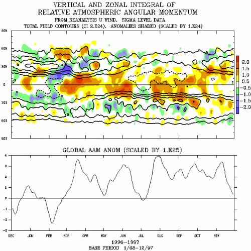
Does anyone know a link where I can go to plot the latest Relative AAM chart such as the one attached? Thanks! LEO
-
Pitiful...just pitiful...

-
I sure hope so...this winter is absolutely disgusting. Makes 2001-02, 2011-12 & 2019-20 look good.
-
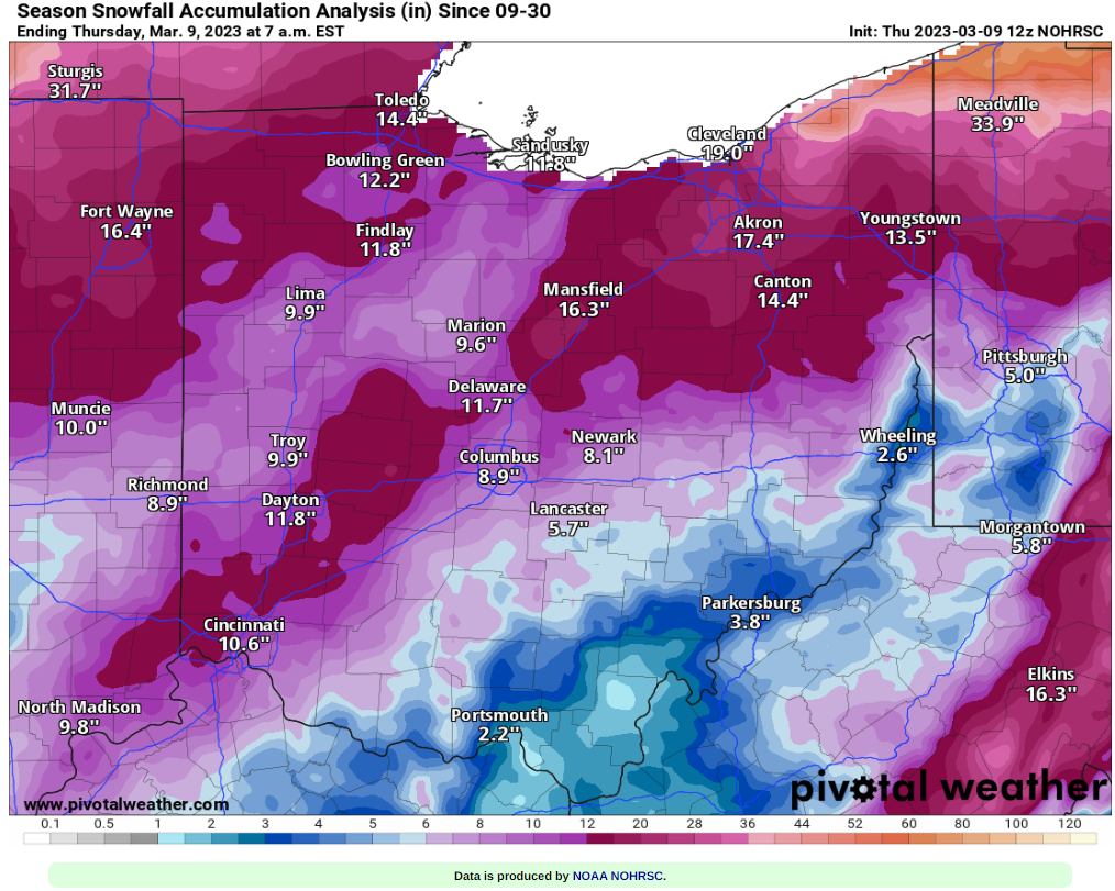
This winter has got to be a record setter for the Snowbelt as far as lack of snowfall goes. Chardon, so far this season, has had just under 40". Ugh! I hope the saying "What a difference a year makes" applies to next winter.
-

My Winter Outlook for 2022-23
LakeEffectOH replied to raindancewx's topic in Weather Forecasting and Discussion
Curious here...does anyone think last year's Hunga Tonga volcanic eruption contributed to pattern disruptions causing this winter's extreme warmth? This eruption blasted a tremendous amount of water vapor into the stratosphere. -
Best of luck for your travels. Be safe and warm.
-
Ok, that makes more sense...
-
In Ashtabula County? That's close...
-
Wind's picked up here. Some little snownadoes now happening.
-
I don't see that weird hole on the 18z HRRR.
-
The heavier snow has gotten more consistent now as opposed to the off and on bursts like I saw earlier.
-
How much do you think you've gotten?
-
I know what you mean. In Chesterland is alternates between light/moderate snow with heavier bursts. Had about 3 inches so far.
-
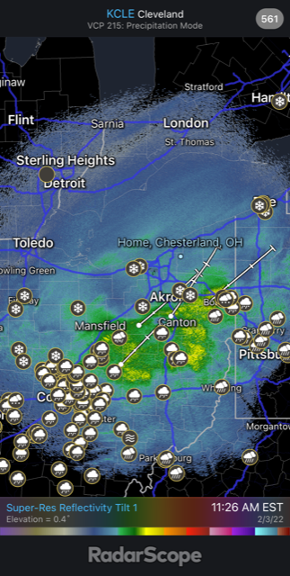
Sure, maybe bad data. Would be crazy if it verified! Meanwhile, the radar looks good. Definite SW-NE movement up 71.
-
That hole is weird. Wonder what the models are seeing or did they ingest something weird from a common dataset??
-
Good news! Radars look good...
-
Radar shows heavier precip moving up I-71.
-
Snow is moderate here. So far, looks like there are 2-3 inches of new snow on my deck.
-
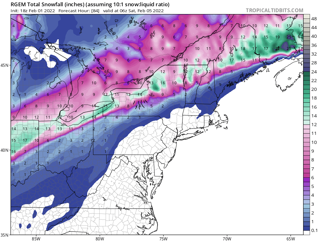
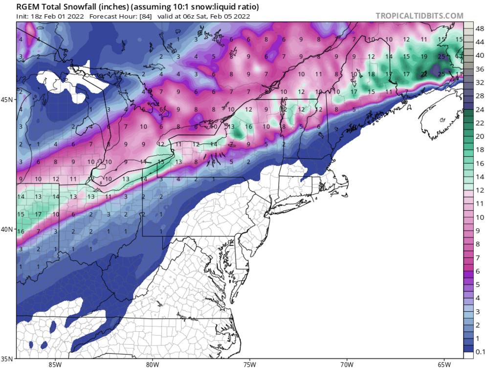
18z RGEM has come appreciably south.
-
Does anybody know why Lake and Cuyahoga county are under a winter storm warning while a winter storm watch is still in effect for Geauga and Ashtabula county. For sure, CLE is not thinking of the possibility of putting these counties under and advisory...
-
RGEM looks like it trended south a bit. Previous runs showed the snow hardly touching the lakeshore.
-
I listened to BAMWX's storm discussion and the Met said that after watching these kind of storms for several years, he thinks there may be some southward drift in the accums, but a pretty hard hit of snow for NEOH.
-
I think you're right!
-
Toledo deserves a good one! So far, this has been a lousy winter for you guys in terms of snowfall.
-
12z Euro ran just a bit south. No system split like the GFS was showing.