Hurricane Agnes
-
Posts
9,263 -
Joined
Content Type
Profiles
Blogs
Forums
American Weather
Media Demo
Store
Gallery
Everything posted by Hurricane Agnes
-
E PA/NJ/DE Spring 2023 OBS Thread
Hurricane Agnes replied to Hurricane Agnes's topic in Philadelphia Region
Solid 75 IMBY with 57 and partly cloudy. Heard someone nearby pull out the lawn mower. -
E PA/NJ/DE Spring 2023 OBS Thread
Hurricane Agnes replied to Hurricane Agnes's topic in Philadelphia Region
Latest severe storms reporting - I know one of those was barreling on the ground not far from Great Adventure and I hope they really check and double check and triple check before trying to reopen Wednesday. -
E PA/NJ/DE Spring 2023 OBS Thread
Hurricane Agnes replied to Hurricane Agnes's topic in Philadelphia Region
You were the first one I was thinking of when I saw them mention "Wrightstown". Glad you guys got through that! -
E PA/NJ/DE Spring 2023 OBS Thread
Hurricane Agnes replied to Hurricane Agnes's topic in Philadelphia Region
Definitely where you are! I know I grew up with the "avoid planting until after Mother's Day" and for the tenders, we wait until after Memorial Day. A lot of garden centers have been wiped out in the past and will often hold back on putting out tender annuals (mostly veggie plants like tomatoes and peppers) until later in May, although a few forget and sometimes get their plants fried expectantly. -
E PA/NJ/DE Spring 2023 OBS Thread
Hurricane Agnes replied to Hurricane Agnes's topic in Philadelphia Region
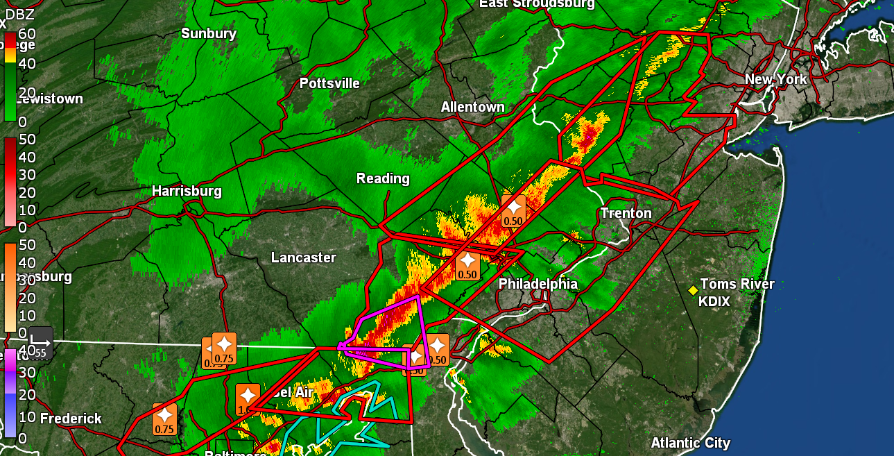
Finally getting chance to post but latest summary from Mt. Holly - 2 EF1s from 6 tornadoes confirmed - -
E PA/NJ/DE Spring 2023 OBS Thread
Hurricane Agnes replied to Hurricane Agnes's topic in Philadelphia Region
With the rain that we have gotten so far, assuming it doesn't suddenly go bone dry, chances are there would be no "triple digit" summer. I do recall a pile of heatwave or near-heatwave 3rd-week-of-Aprils during my years of living in an apartment building that had central heat/air and that didn't turn on the chillers until May. Ended up buying my own window AC to mitigate that. Glad to be in a house with a thermostat that I can control. -
E PA/NJ/DE Spring 2023 OBS Thread
Hurricane Agnes replied to Hurricane Agnes's topic in Philadelphia Region
I have seen frosts as late as the 2nd or 3rd week of May. I had actually bottomed out at 40 on May 8, 2017 and I expect it was colder north and west of here. But for now, I'm at 61 and mostly sunny with dp up to 41. -
E PA/NJ/DE Spring 2023 OBS Thread
Hurricane Agnes replied to Hurricane Agnes's topic in Philadelphia Region
Looks like I bottomed out at 32 at 6:19 am this morning (with dp having gone as low as 13) and then a couple puffs of a breeze broke that up. Currently sunny and 37 with dp recovering and at 24. -
E PA/NJ/DE Spring 2023 OBS Thread
Hurricane Agnes replied to Hurricane Agnes's topic in Philadelphia Region
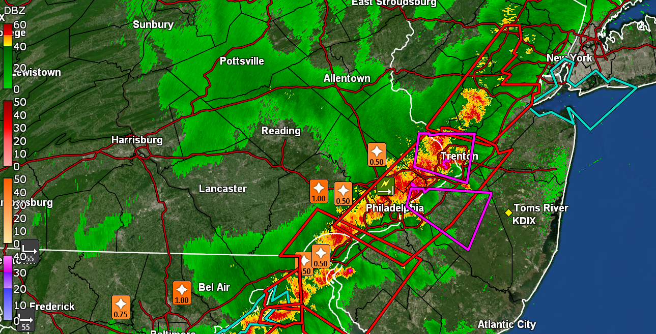
A 5th tornado (4th for NJ) confirmed - Cinnaminson tornado was determined to be an EF1 - -
E PA/NJ/DE Spring 2023 OBS Thread
Hurricane Agnes replied to Hurricane Agnes's topic in Philadelphia Region
3 more confirmed tornadoes - all in New Jersey - -
E PA/NJ/DE Spring 2023 OBS Thread
Hurricane Agnes replied to Hurricane Agnes's topic in Philadelphia Region
One of Brett Adair's crew chase of the Bridgeville, DE tornado - -
E PA/NJ/DE Spring 2023 OBS Thread
Hurricane Agnes replied to Hurricane Agnes's topic in Philadelphia Region
Tornado confirmed near Bridgeville, DE - Also for the tier now with the growing season underway, some frost/freeze headlines are up - There is a star magnolia not far from me that has been in bloom for sometime although I expect it is past its peak. My lilacs have started leafing out although I don't think the late-blooming one has flower buds up yet (have to look closely). That one doesn't normally bloom until May. -
E PA/NJ/DE Spring 2023 OBS Thread
Hurricane Agnes replied to Hurricane Agnes's topic in Philadelphia Region
Enough to get you outta storage and posting after that event yesterday! -
E PA/NJ/DE Spring 2023 OBS Thread
Hurricane Agnes replied to Hurricane Agnes's topic in Philadelphia Region
LSRs that were posted last night (the "train flipped over" certainly caught my attention ) - Full list - -
E PA/NJ/DE Spring 2023 OBS Thread
Hurricane Agnes replied to Hurricane Agnes's topic in Philadelphia Region
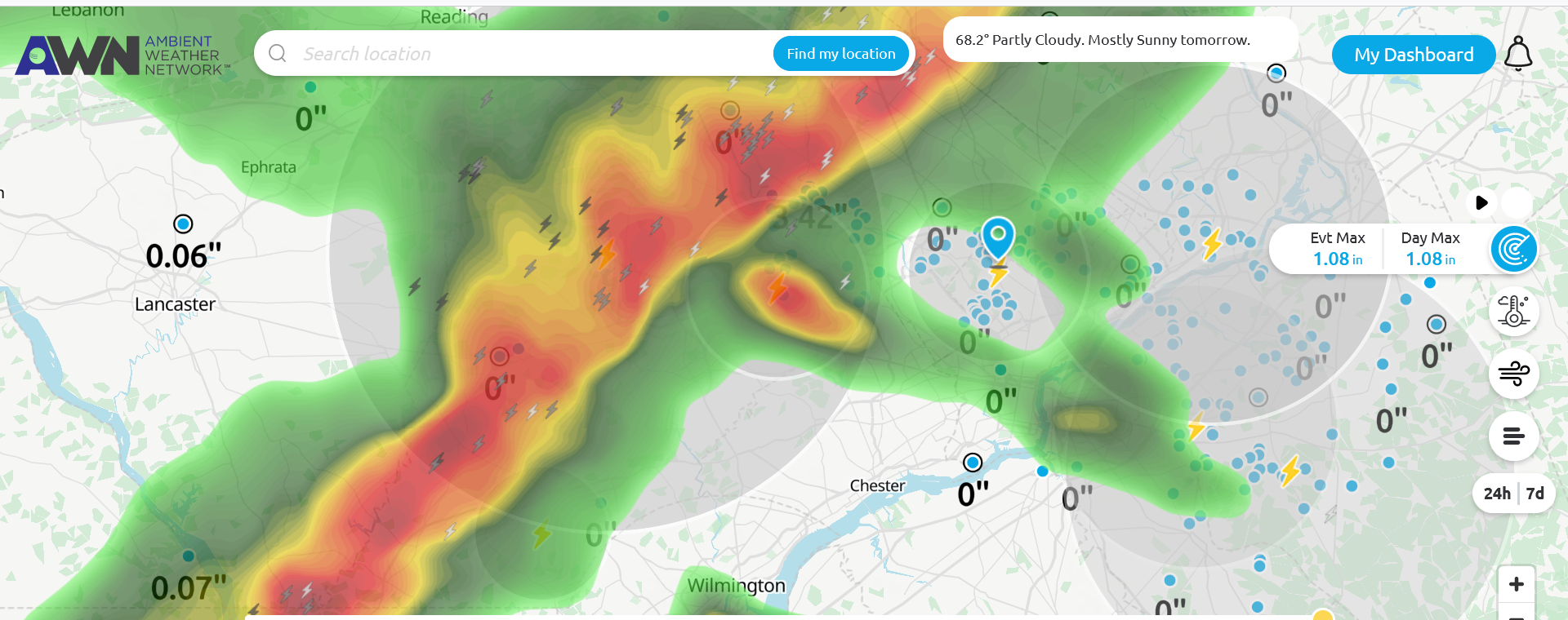
Survey teams due to go out today for the locations that had TORs up yesterday - My final high for yesterday was 69 with the 1.24" of rain. Low so far this morning has been 41 and it's currently mostly sunny and 43, with dp slowly dropping and down to 26. -
E PA/NJ/DE Spring 2023 OBS Thread
Hurricane Agnes replied to Hurricane Agnes's topic in Philadelphia Region
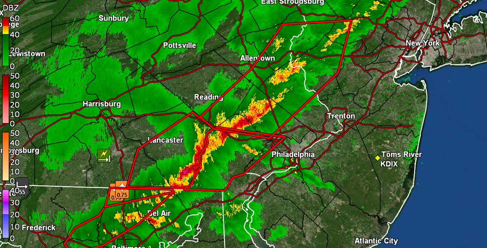
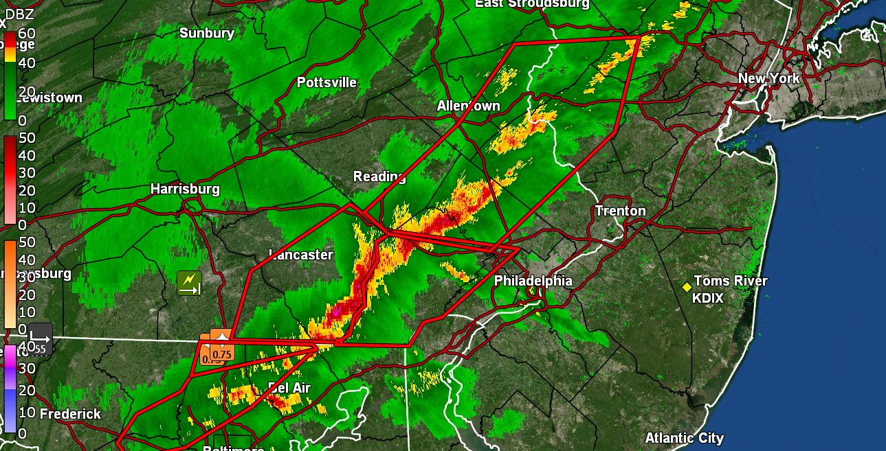
There was something that had spun up in Jersey.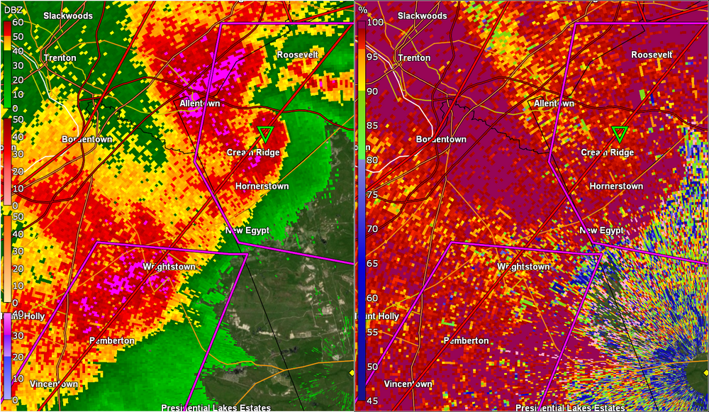
-
E PA/NJ/DE Spring 2023 OBS Thread
Hurricane Agnes replied to Hurricane Agnes's topic in Philadelphia Region
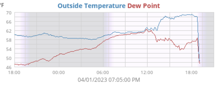
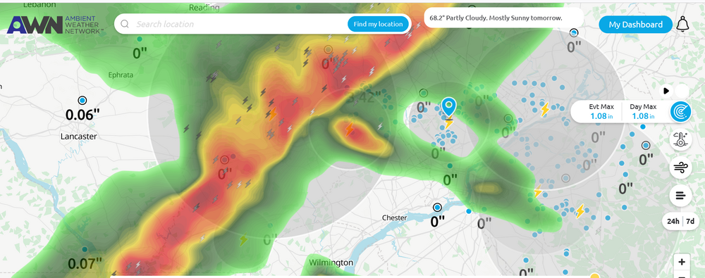
I actually had what I am calling pain-inducing "bean sized" hail - something that I don't recall ever seeing here. The hail that we saw when I was a kid was mostly the pea-sized. This stuff was much bigger. As it is, this past year was the first in many years that I have had hail here - most times that small stuff has already melted before it hits the ground and it comes down in large droplets vs actual frozen stuff. Currently recovering from that steep temp drop and am at 52 with dp 51. Picked up an additional 0.85" of rain so far from round 2 for a total of 1.24" for the day.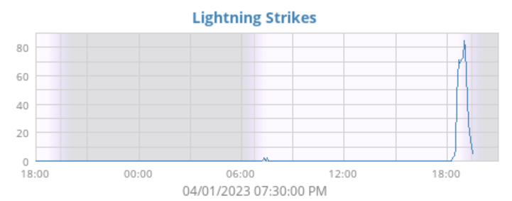
-
E PA/NJ/DE Spring 2023 OBS Thread
Hurricane Agnes replied to Hurricane Agnes's topic in Philadelphia Region
I'm a couple miles east of where a tree went down on Bell's Mill Rd. here in Chestnut Hill per the report. Temp dropped like 20 degrees and am down to 49! with dp 49.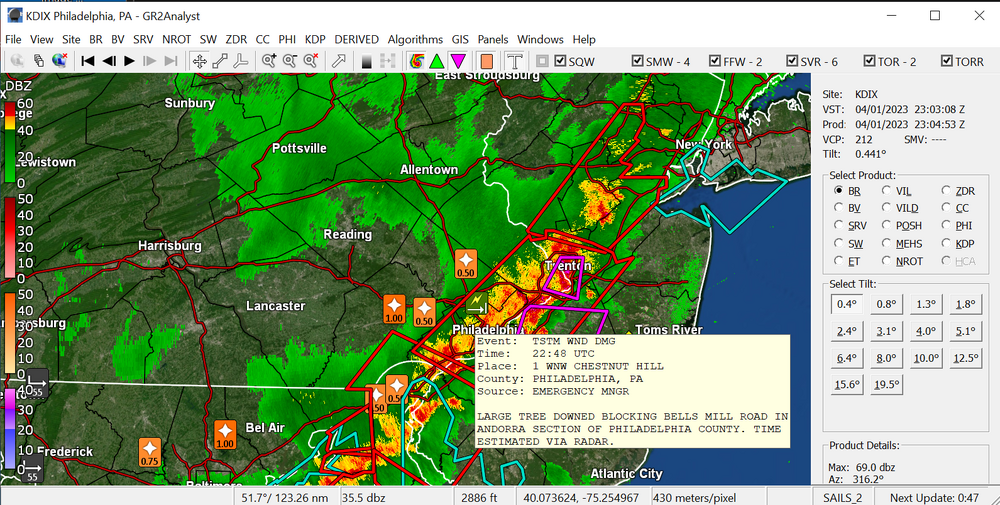
-
E PA/NJ/DE Spring 2023 OBS Thread
Hurricane Agnes replied to Hurricane Agnes's topic in Philadelphia Region
TORs up for part of NE Philly and across into Jersey around Princeton. I actually have an "accumulation" of "bean size" (bigger than peas) hail that was more than I got for snow from any individual storm this past winter.
-
E PA/NJ/DE Spring 2023 OBS Thread
Hurricane Agnes replied to Hurricane Agnes's topic in Philadelphia Region
Bigger HAIL. Yikes!!! Haven't had something like that here since I was a kid. -
E PA/NJ/DE Spring 2023 OBS Thread
Hurricane Agnes replied to Hurricane Agnes's topic in Philadelphia Region
Winds gusting. HAIL. Pea-sized and under a gully washer. -
E PA/NJ/DE Spring 2023 OBS Thread
Hurricane Agnes replied to Hurricane Agnes's topic in Philadelphia Region
Getting the first of the rain. Sky lighting up like July 4 with lots of soft thunder in the distance. Temp 68 with dp 60. -
E PA/NJ/DE Spring 2023 OBS Thread
Hurricane Agnes replied to Hurricane Agnes's topic in Philadelphia Region
-
E PA/NJ/DE Spring 2023 OBS Thread
Hurricane Agnes replied to Hurricane Agnes's topic in Philadelphia Region
Thing is booking.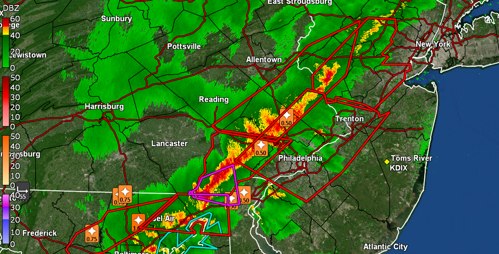
-
E PA/NJ/DE Spring 2023 OBS Thread
Hurricane Agnes replied to Hurricane Agnes's topic in Philadelphia Region
Right on my doorstep soon.