

Hurricane Agnes
-
Posts
8,976 -
Joined
Content Type
Profiles
Blogs
Forums
American Weather
Media Demo
Store
Gallery
Posts posted by Hurricane Agnes
-
-
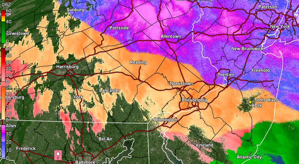
Started at 32 and rain and now am at 30 and light rain = ZR.
 Didn't get any ip or snow preceding or during. The dp did shoot up from 18 to 25.
-
7 hours ago, Birds~69 said:
I've been on this board, back then Eastern weather, for over 20 years. Those long-term, 300 hour models rarely pan out, maybe once in a blue moon. Should have a thread for 5 days and in threats. Then once we get within 2 days or so create a thread for that event. And create a thread for long-term weenie threats which I would look at here and there but certainly not pay close attention to the event draws near. Long-term threats in the current ops is silly and clogs everything up for nothing because they usually fail. Basically take one storm at a time...
I have noticed the LR models DO tend to "sniff out" something (whether it pans out "positive" or not), but then it all gets muddled and garbled in the midrange.
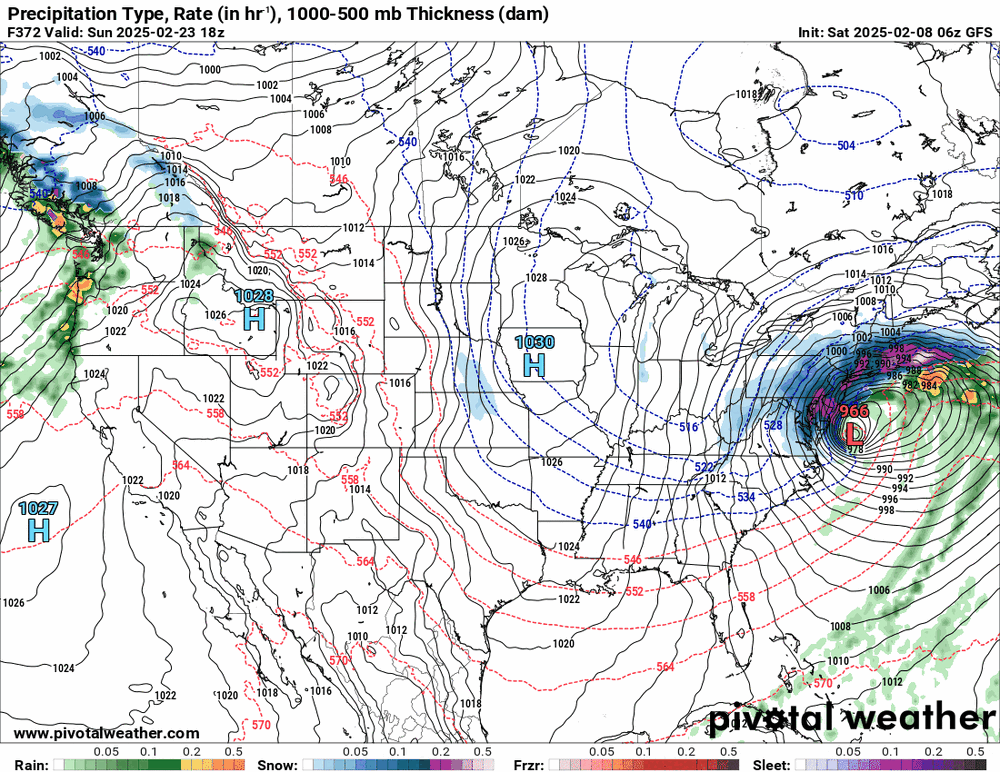
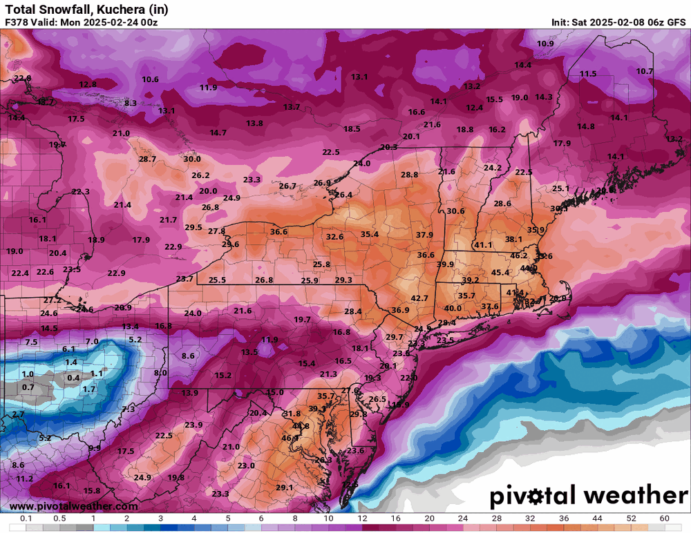
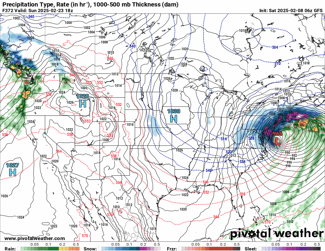
Looks like the 18z GFS has the Wed. storm do a slide to the south and the Friday one is a thump to rain.
As an obs, it's currently overcast and 33 with dp 14.

-
BG confirmed to play!
https://apnews.com/article/super-bowl-2025-eagles-graham-fb61a5abd427e84b0c79c45b67e752d3
Hope he will help make a difference as a SB winner vet.

-
 2
2
-
 1
1
-
-
7 hours ago, RedSky said:
GFS is north but needed a south trend, then south when we needed a north trend and north when we needed a south trend lol
Am looking out the window right now to the east and see your namesake in all its glory!
Made it up to 44 yesterday and am currently at my low of 26 for today with dp 12.
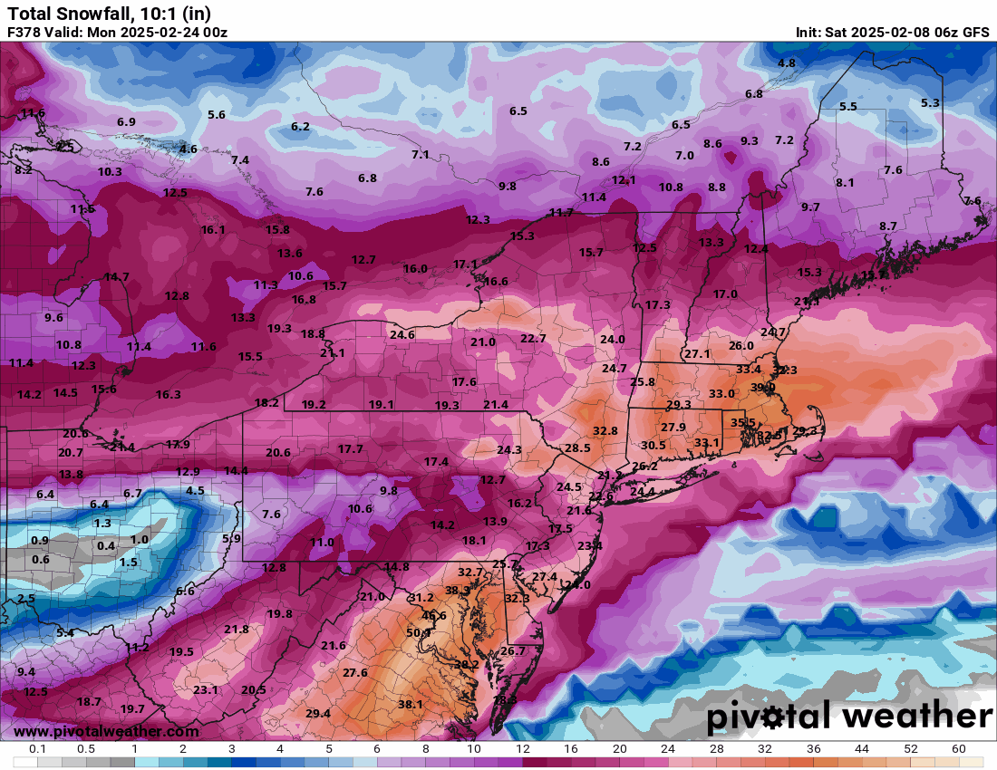
Some stuff outta the 6z GFS at the end of the run
 .
.

-
On 1/28/2025 at 9:24 PM, JTA66 said:
Ah, gotcha. I had to look up who played in the Super Bowl way back in 2020. It was so long ago and my memory ain’t what it was

Then the Vermeil years would be but a twinkle!

-
 1
1
-
-
1 minute ago, Ralph Wiggum said:
Don't do it to yourself. Seriously,walk away:
Or better - the last lyric - Know when to RUN!!!!
-
1
-
-
2 hours ago, LVblizzard said:
SECS on the GFS for next weekend. Here we go again…

-
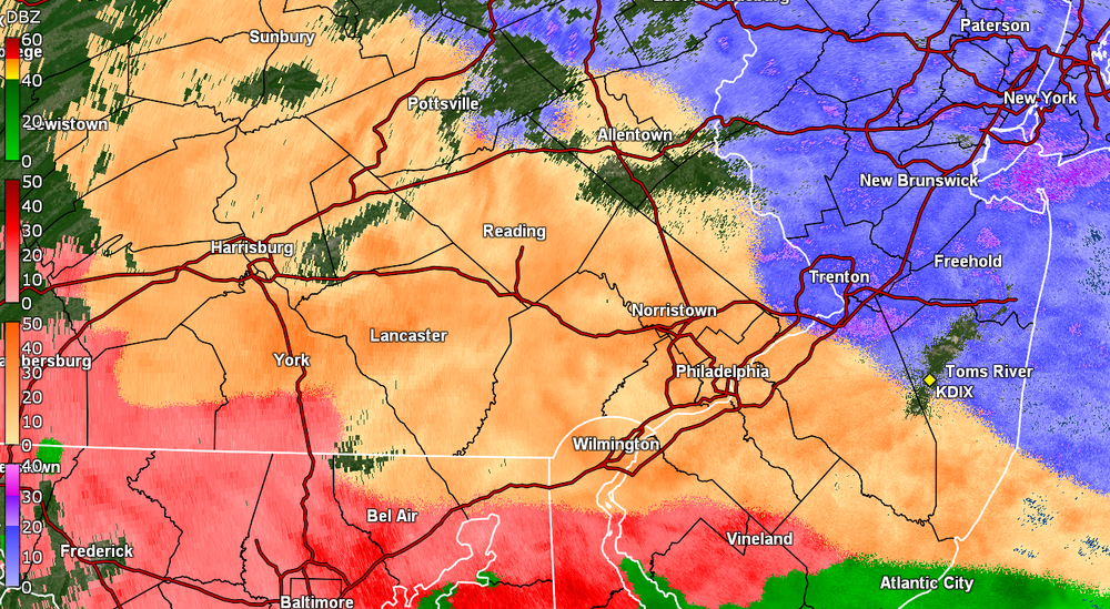
Looks like this system is pretty much out of here. I ended up with 0.1" of ice accretion but found that out back on colder grassy areas (back faces NE), there was about 0.2" IP (sleet) that had fallen overnight. None of that was out front, which was heavily treated and faces SW, or even on my patio, but was away from the house and in open areas nearby.
Currently a misty 34, with some fog/low stratus, and a dp 34. Bucket tips resulted in 0.08" liquid, as anything that had accumulated in there and froze, has melted.
-
1
-
-
Still getting ZR (moderate) and although I am registering 0.05" in the bucket, I expect the tipper might be frozen.
Temp is 31 with dp 30 (earlier fog/low stratus appears to have dissipated).
-
Currently 30 here with dp 28, and not seeing any snow or getting any pingers but ZR.
Getting a coating of ice on car, trees, and untreated surfaces.
-
1
-
-
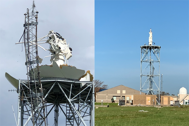
10 minutes ago, MGorse said:
Anyone have a Blizzard Warning today for southwestern Louisiana on their bingo card?
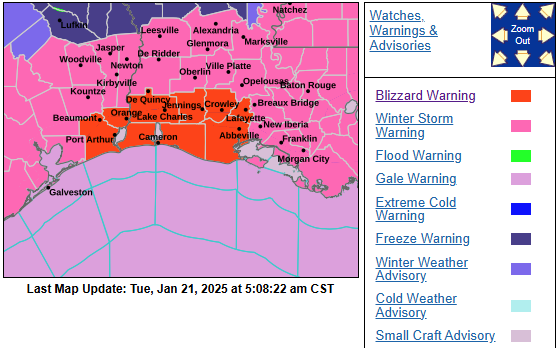
I remember watching chasers in Lake Charles back in 2020 when Hurricane Laura blasted through (and eventually obliterated their NEXRAD and it took 5 months to get it back up and operational again) - https://www.weather.gov/news/012221-lake-charles-radar

-
Made it up to 25 yesterday as a high after a 12 low and got what I could off the car and found a crusty layer under the fluffy snow. Currently down in the single digits here at 8, with a dp of 1.
11 hours ago, RedSky said:Millions of people that have never experienced snow at all or seen anything but flakes or a coating are in for an experience.
Have to thank Voyager for allowing the Southtown snow!
-
1
-
-
Finished up with 3.75" from the storm and bottomed out at 16 this morning. Season total so far is 8.61".
It's currently a sunny 22 with dp 14.
-
Just measured before the winds kick in and finished up with 3.75". There is a crunchy layer at the bottom of this stuff here too.
-
1
-
-
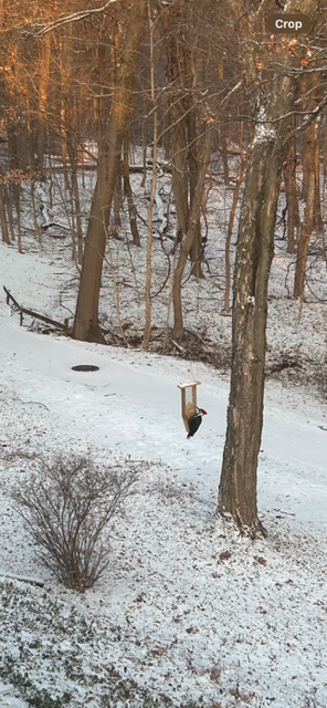
24 minutes ago, Violentweatherfan said:
Is she sure they’re not from carpenter bees
We've actually seen them hanging on the rail pecking. The guy who originally owned the house before my sis and BIL bought it (just over 20 years ago) had built a custom deck (it's like 15 ft wide by 25 ft deep) and used "indoor" wood banister-type railing as the deck rail (and then stained/painted it).
The little guys were also all over the wooden playhouse/swing set that my sis had when my niece was little. You can tell the carpenter bee holes because they are perfectly round! I remember way back having a carpenter bee make a "home" in my broomstick.

As an obs, I think I may be pretty much done and aside from a few flurries, it's overcast, breezy, and the temp has been dropping. Am down to 23 with dp 21.
-
1
-
-
Am down to SN- with some fatties mixed in, and even have some breaks in the clouds although I expect that will close over as the back edge moves this way.
8 minutes ago, RedSky said:They show up on suet feeders here
6 minutes ago, Violentweatherfan said:Yeah, visits every day. I hear her yapping and drumming on a daily basis. I have about 30 species that visit my feeders since I moved to Jamison, Eastern Bluebirds are a special sight to see
4 minutes ago, Violentweatherfan said:I had to customize that suet feeder just for the Pileated Woodpecker, double cake jawn
Those are good-sized birds. My Montco sis gets the smaller downy woodpeckers who manage to make buckshot holes all over her deck rails.
-
55 minutes ago, Violentweatherfan said:
Looks like a pilated woodpecker! Didn't consider if they ever went to feeders but there it is...
-
1
-
-
Just measured 3.5" here with SN and some bigger flakes mixing in. The snow seems wet so I expect there is definite compaction. Currently getting snow and fog with temp 26, and dp 26.
-
1
-
-
Have to add this -
-
3
-
 1
1
-
 1
1
-
1
-
-
About an hour ago, someone kicked in the after-burner and the temp dropped below freezing, the graupel machine was engaged, and the winds kicked in, blowing stuff around. Did a 6:15 pm measure and have 3.25", which considering the dry slot, above-freezing temps, and white rain earlier, had kept the accumulations down for at least an hour or more before something finally started to pile up.
Currently SN and 27 with dp 27.
-
2
-
1
-
-
And jumbo dryslot opened up over me leaving nothing but drizzle. Am still sitting at 32 and everything has been slowly melting/dripping. I did a 2:30 pm measure and barely got 0.25", which I expect is compacting.
Currently misty and 32 with dp 31.
-
1
-
-
Once the temp dropped to 32 and I got under a heavier return, some of the treated surfaces (that were done for the last storm) caved. Getting back and forth snizzle and then SN.
ETA - dry slot looks like it wants to fill the gap but will see.
-
2
-
-
The previous hour or so of precipitation resulted in no stickage whatsoever. Once the temp eased down to 33, I'm finally seeing some of the grassy areas cave as well as some untreated cold surfaces. Have been getting intermittent white rain.
My Delco sis texted that she was getting sleet down in the Upper Darby area.
Currently SN- and 33 with dp 31.
-
1
-
-
Flurries began here within the past 45 minutes but am now up to SN. Temp is still above freezing at 35 & dp 31 but slowly creeping down as everything cools.
44 minutes ago, Birds~69 said:Drunk snow has sobered up a bit and it's coming down a little more consistent...
35f
They have been tailgating ahead of the game so they can eventually become snow cones.
-
 1
1
-
2
-


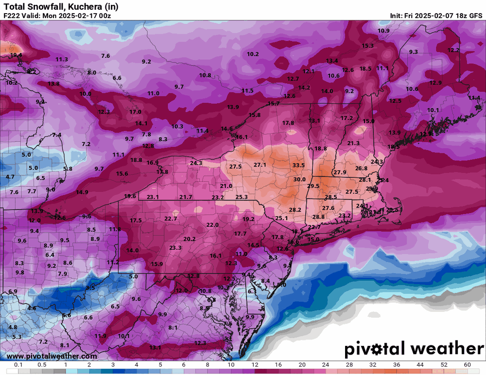
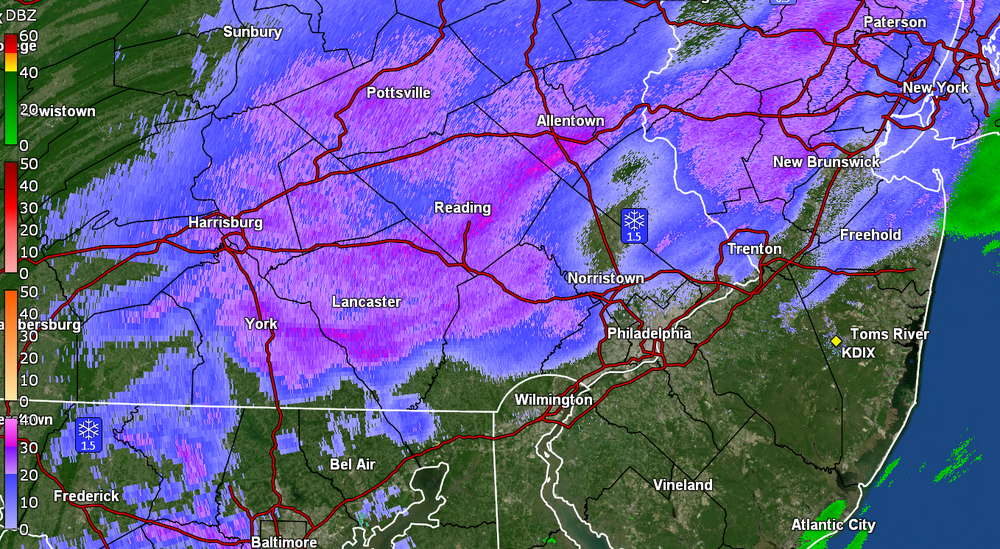
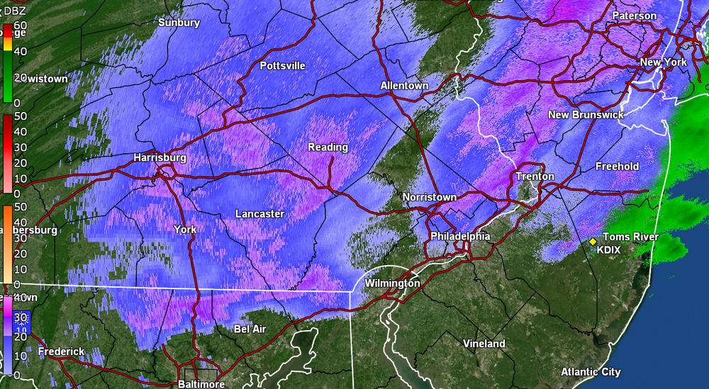
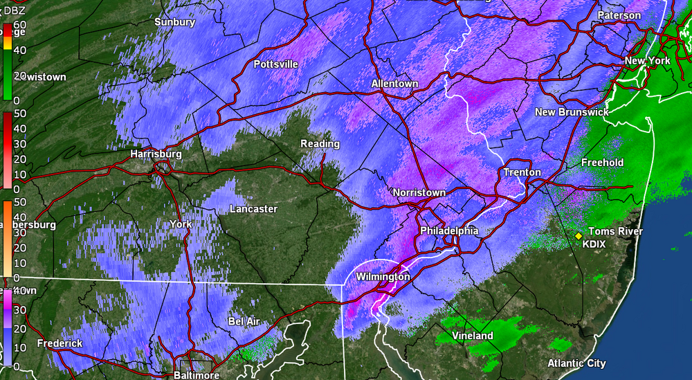
2/8-2/9 Wintry Mix Event
in Philadelphia Region
Posted
Temp here is down to 29 (dp 26) and have finally been getting a mix - mostly rain but finally got sleet alternating in enough to deposit a 0.25" coating at post time. Accretion is building with the rain in any event. Bucket at 0.05" at post time.