

Hurricane Agnes
-
Posts
8,579 -
Joined
Content Type
Profiles
Blogs
Forums
American Weather
Media Demo
Store
Gallery
Posts posted by Hurricane Agnes
-
-
Ended up with 0.49" of rain in the bucket on Wed. and finished up with 0.10" on Thurs. for a 2-day total of 0.59".
Made it up to 55 for a high yesterday after a 39 low, and touched 60 today after a 38 low.
It has clouded over now as some rain is approaching, and temp is 58 with dp that has crept up to 33.
-
On 3/25/2024 at 1:17 PM, JTA66 said:
And the opener was postponed.
 And I remember a certain World Series game years ago when the rain was just coming down like crazy.
Well I was able to get out early this afternoon, take care of an appointment, get air in one of my tires, and get home just as it started spritzing. Getting heavier showers now.
Past couple days of highs/lows were 52/32 & 58/36. This morning's low was a milder 42 and made it up to 49 before the rain started. Currently 46 with light rain, dp 44, and 0.09" in the bucket at post time.
-
And the winds have arrived here. Literally has the house creaking and groaning.

Temp down to 36 with dp 30.
-
Had one more bucket tip to finish up with 3.24" and the sun popped out within the past hour.
Made it up to 47 for a high but the temp and dp are dropping quickly. Currently partly sunny and 41 with dp 37.
-
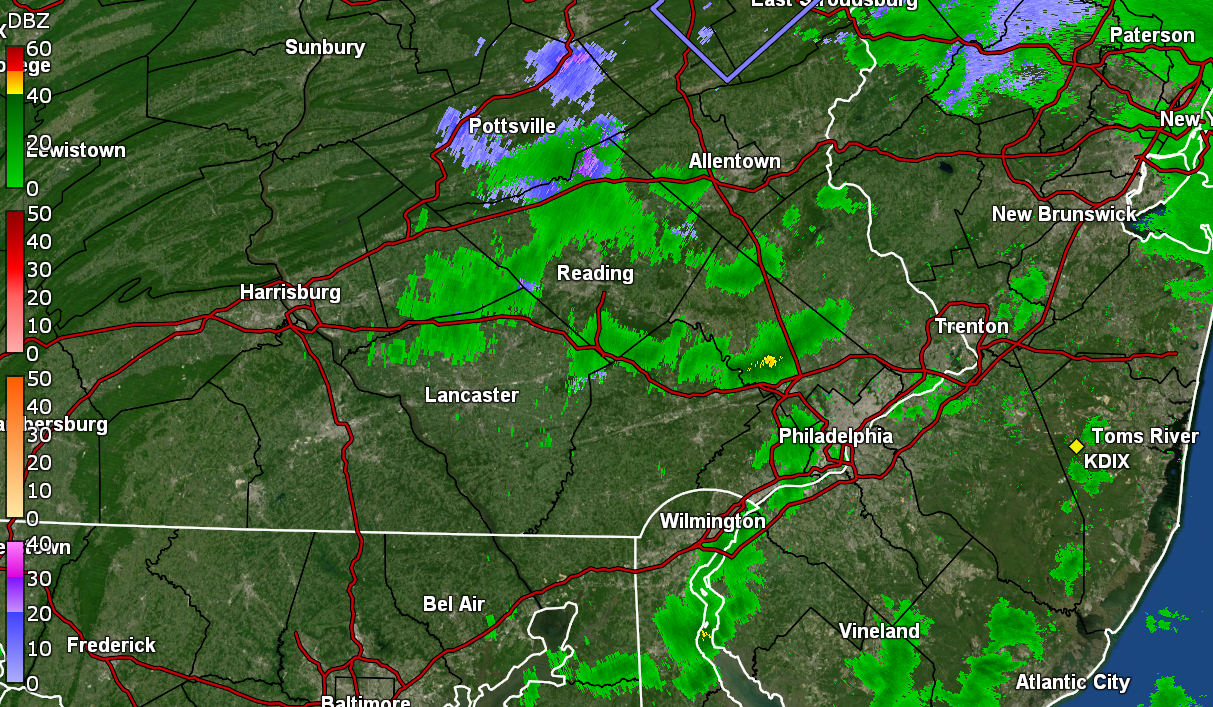
The back edge is pivoting away and I'm currently at 3.23" in the bucket. Temp is currently 46 with dp 46.
-
 1
1
-
-
19 minutes ago, donsutherland1 said:
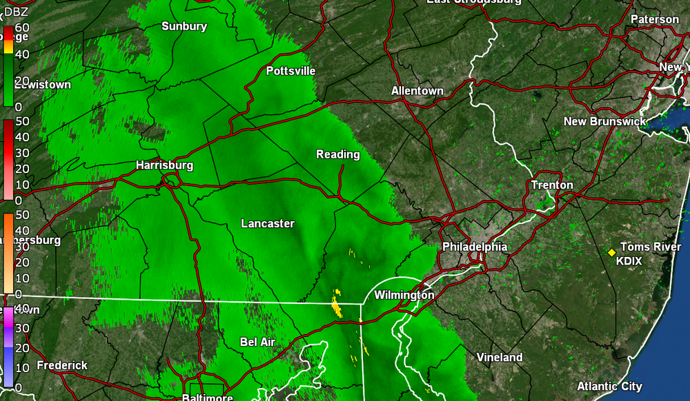
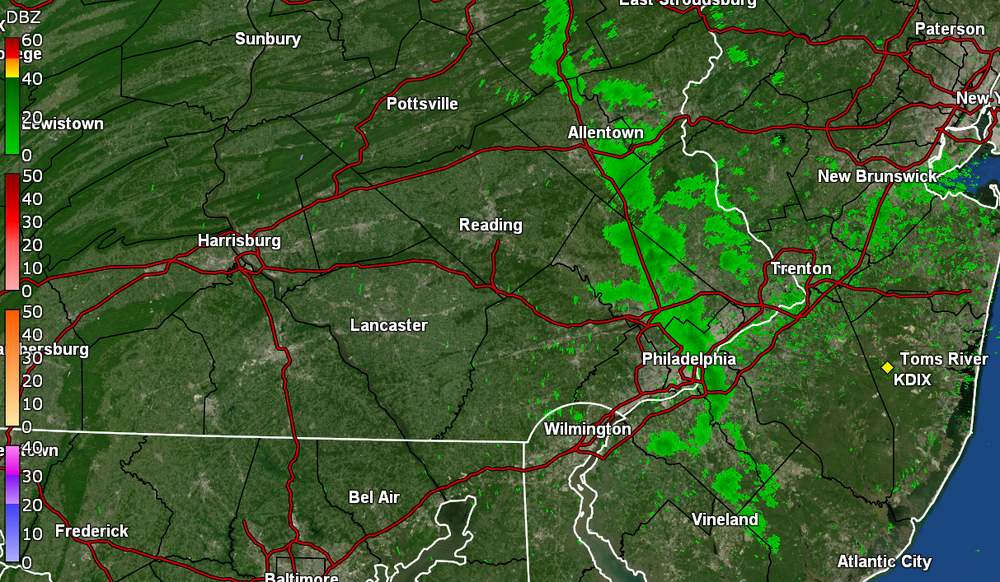
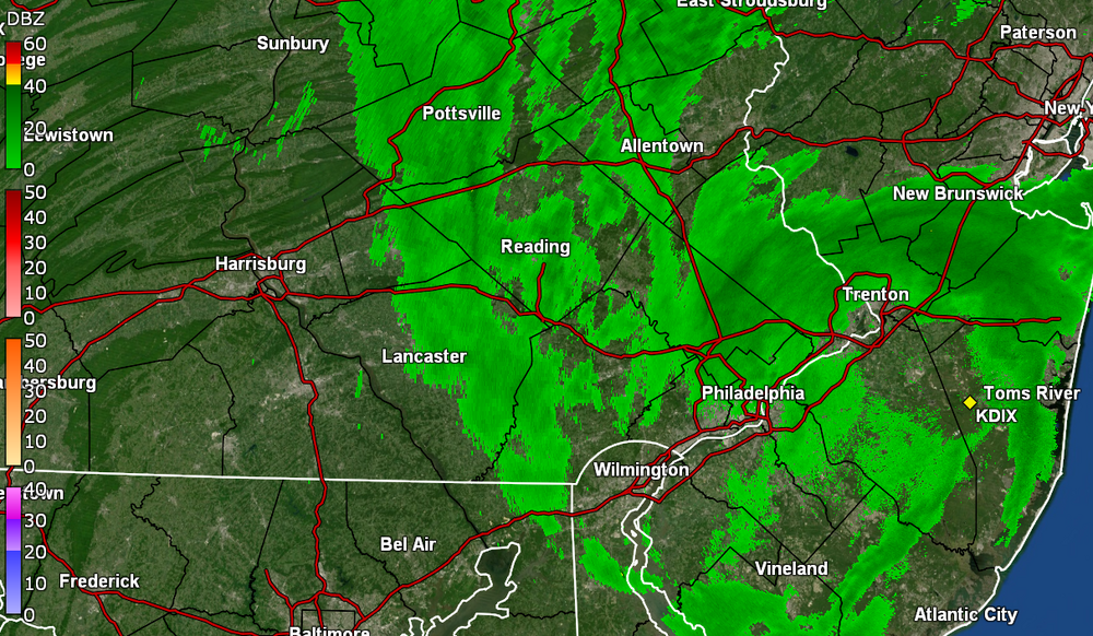
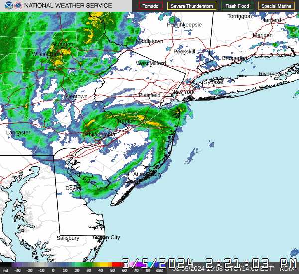
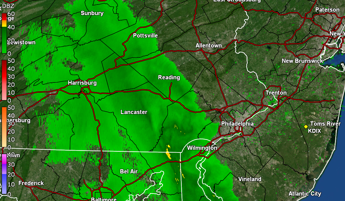
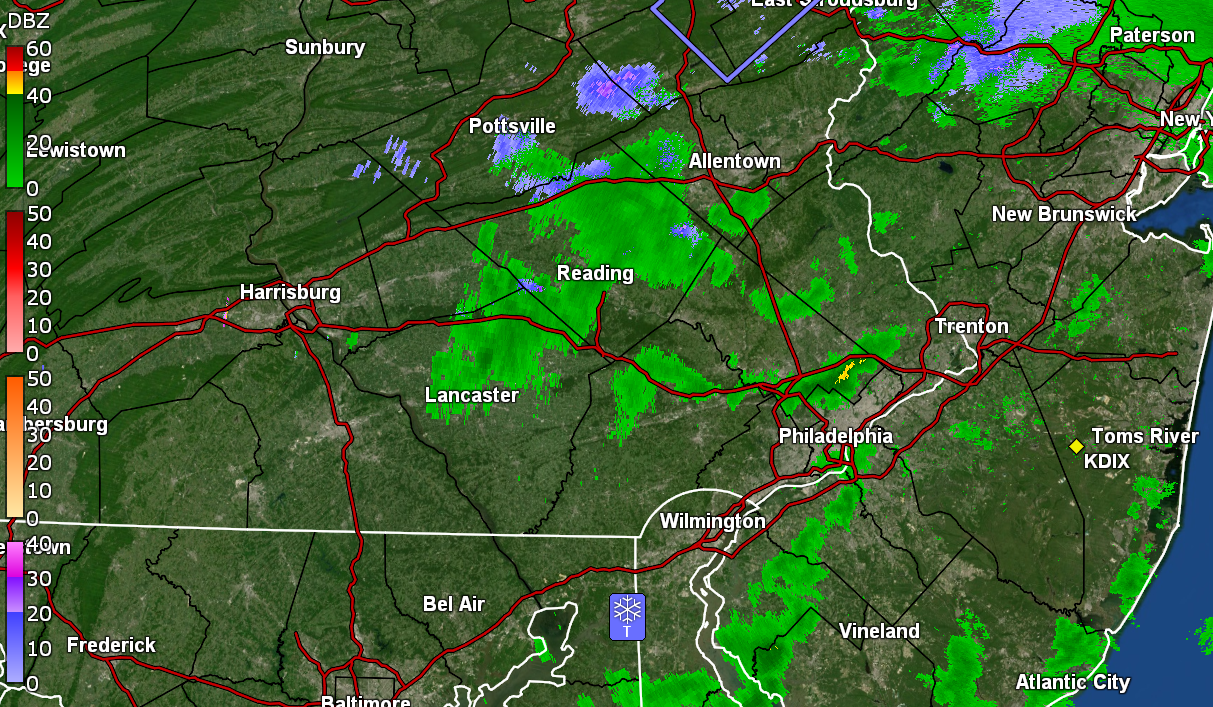
Philadelphia has now picked up 2.80" of rain today. That makes March 23, 2024 Philadelphia's wettest March day on record. The old record of 2.79 was set on March 15, 1912. March records go back to 1872.
I had been following the Climatology section on this for the CWA -
Quote&& .CLIMATE... Widespread heavy rainfall is forecast across the forecast area on Saturday, March 23rd. Below is a list of the daily precipitation records for the date as well as all time daily records for March. March 23rd Daily Precipitation Records Allentown (ABE) 1.12" in 2005 AC Airport (ACY) 1.59" in 2005 AC Marina (55N) 1.88" in 2005 Georgetown (GED) 2.09" in 2005 Mount Pocono (MPO) 3.13" in 1977 Philadelphia (PHL) 1.36" in 2005 Reading (RDG) 2.22" in 1903 Trenton (TTN) 1.62" in 1961 Wilmington (ILG) 2.05" in 1903 All Time Daily Precipitation Records for March Allentown (ABE) 2.99" on 3/11/1952 AC Airport (ACY) 3.02" on 3/14/2017 AC Marina (55N) 3.30" on 3/13/1993 Georgetown (GED) 3.21" on 3/21/2000 Mount Pocono (MPO) 4.36" on 3/10/2011 Philadelphia (PHL) 2.79" on 3/15/1912 Reading (RDG) 3.03" on 3/20/1958 Trenton (TTN) 3.62" on 3/25/1876 Wilmington (ILG) 3.21" on 3/21/2000 && .PHI WATCHES/WARNINGS/ADVISORIES... PA...Flood Watch through Sunday morning for PAZ060>062-070-071- 101>106. Wind Advisory from 4 PM this afternoon to 8 AM EDT Sunday for PAZ054-055-060>062-070-071-101>106. NJ...Flood Watch through Sunday morning for NJZ001-007>010-012>027. Wind Advisory from 4 PM this afternoon to 8 AM EDT Sunday for NJZ001-007>010-012-015>019-021. Wind Advisory from 11 AM this morning to 8 AM EDT Sunday for NJZ013-014-020-022>024-026-027. DE...Flood Watch through Sunday morning for DEZ001>004. Wind Advisory from 4 PM this afternoon to 8 AM EDT Sunday for DEZ001-002. Wind Advisory from 11 AM this morning to 8 AM EDT Sunday for DEZ003-004. MD...Flood Watch through Sunday morning for MDZ012-015-019-020. MARINE...Gale Warning until 11 AM EDT Sunday for ANZ430-431. Gale Warning until 6 PM EDT Sunday for ANZ450>455. && $$ SYNOPSIS...AKL/Robertson NEAR TERM...DeSilva/Fitzsimmons/Gorse SHORT TERM...AKL LONG TERM...AKL AVIATION...AKL/Fitzsimmons MARINE...AKL/Fitzsimmons HYDROLOGY... TIDES/COASTAL FLOODING... CLIMATE...
I crossed over the 3" mark within the past 30 minutes and am currently sitting at 3.04" in the bucket. The heaviest rates were upwards of about 3/4" an hour so far today.
Currently 45 with moderate rain and dp 45.
-
3
-
-
9 hours ago, Birds~69 said:
Lived 5 houses down on 2nd Ave where that fire happened yesterday in Royersford. Probably could have been contained to 1 or 2 homes but winds cranking made it a 6 home destruction...
When I heard about this on the news, I was thinking of folks in this forum and whether any were near that. Just sad.
Past couple mornings here have had lows at or below hard freeze temps. I.e., high/lows for Thurs. & Fri. were 42/28 & 46/27. The dry air with dps down in the teens earlier in the week seemed to help the radiational cooling.
There have been a lot of saucer magnolias around here that have been in full bloom although now just past peak, so some of those got hit with petal damage along with some of the early cherries (also past peak). The daffodils that have been blooming in the area didn't get phased by it, as they are pretty tough.
Currently have light - moderate rain (0.40" in the bucket at post time), with a low of 39 that happened about 1:30 this morning. Temp has crept up to 42 with dp 42.
-
1
-
-
14 hours ago, RedSky said:
Weather World is predicting stuck in the mud season with a particularly wet stretch through April 17th
Guess El Nino dry springs are a thing of the past
https://www.cpc.ncep.noaa.gov/products/analysis_monitoring/enso_advisory/ensodisc.shtml
ENSO advisory notes a "La Nina Watch". Expectations to go ENSO neutral starting in April through to June and then La Nina reappearing over the summer. Will have to see if that pans out.
Ended up with a high of 76 yesterday after a 47 low and it's currently a mild 56 with dp 47.
-
44 minutes ago, Birds~69 said:
Live in Linfield directly behind the Power Plant for a couple years. I could see the steam floating aloft from the backyard. Pretty eerie when a TS was approaching w/the lightning...I could see the towers/lightning and steam billowing out all in one picture/glimpse. And those towers are way huge. It would have made for a cool picture...
Once I moved to Royersford I didn't notice the power plants even though I was only a couple miles down the road...
LOL I remember as a senior in high school back in '79, my high school Physics class took a trip there while it was under construction (the cooling towers were just being built). The PECO tour guide told us that when it was completed, our electric bills would be reduced to $3 a month!

Anyway, it was a gorgeous day today with daffodils in bloom and even some cherry trees. I ended up with a high/low of 66/37 yesterday, and 71/41 today. My last 70+ temp was Oct. 27 of last year.
Currently 56 with dp 38.
-
Under a light flurry shower. Temp at 39 with dp 30.
-
Actually gave me a 0.1" dusting of graupel and rimed flakes. Sun peaking out with some leftover flurries.
ETA temp down to 36 with dp 32..
-
1
-
-
And it got me! Graupel-izzard! (or at least sideswiped)

-
37 minutes ago, Birds~69 said:
Heavy duty sideways squall...
27 minutes ago, Birds~69 said:Sun is out...
7 minutes ago, Birds~69 said:Squall Rd 2....
6 minutes ago, JTA66 said:Heavy snow shower. Glad we get an extra hour of evening daylight in early March, everyone is outside enjoying the beautiful weather
")
Nothing here yet but sun and some dark clouds off to the west. My Upper Darby sis texted that she was under snow squall #2 where she is.
Temp is down to 42 here with dp continuing to fall and at 28.
ETA - will have to see if that cell makes it here.

-
9 minutes ago, Ralph Wiggum said:
That little convective cell was the culprit:
It did something dramatic.
Sun had come out here some time around 9:30 am and then before 11 am, it got dark (was thinking maybe a squall or something but it was too warm for that). Then had the brief light shower and temp drop. Sun is slowly coming out again and temp is back up to 47.
-
 5 minutes ago, Ralph Wiggum said:
And like that precip stopped, temp shot up to 45F, and sun is breaking thru. Gusty.
It was a "line" of something that came through. Had brief non-measurable rain here but it did drop the temp from 50 back down to 43.
-
Finished up with 1.78" of rain yesterday and so far this morning, bottomed out at 43. Currently a misty 44 with dp 42.
-
Bottomed out at 39 this morning and only made it up to 48 as a high with some light rain (once it started) much of the day. The rain has suddenly picked up here in the last hour or so and I'm now up to an 1.04" at post time with almost 1"/hr rates. Some winds are starting to kick in and am currently at 48 with dp 47.
-
Ended up with lows/highs for Wed & Thurs. of 47/50 & 46/56, with 1.16" in the bucket Wed. & 0.04" yesterday (2-day total of 1.20").
My low this morning was cooler than the past couple days, at 39 and so far hit 55 for a high. Was able to get some fertilizer out on the plants this afternoon ahead of this weekend's rain.
The sun has been out much of the day but the clouds are starting to roll in now so it's currently partly sunny and 54 with dp 34.
-
Had a low of 42 this morning and it hasn't moved that much today with the rain. Currently have some light rain and a temp of 46 (the high so far) and 0.39" in the bucket.
Can obviously see where the low is! lol
-
I eventually managed to tap 64 for a high yesterday and had a 44 low this morning. Something came through around 4 pm today and knocked the temps down a bit (it had already clouded up before then), where I hit 65 for a high but am now down to 59, with some stratocumulus overspreading the sky, and dp 50.
-
Ended up hitting 54 yesterday after a low of 38 and picked up 1.50" of rain then. This morning's low was 44 and am currently at my high so far today of 63, with fluffy cumulus drifting in, and a dp of 51.
-
Made it up to 49 for a high today and am watching the junk 'n stuff on the radar headed this way. Currently 40 with dp 28.
-
Ended up hitting 41 for a high on that Feb. 29 leap day after a 30 low and finished up the month with 1.82" of rain/sleet/snow melt (which is probably low due to snow clogging the bucket).
Currently 27 with dp 19.
-
Drier air coming in now. Temp at 47 with dp 38.


E PA/NJ/DE Spring 2024 OBS/Discussion
in Philadelphia Region
Posted
Some of it is over me now but getting virga at the moment although the dp is still going up so I guess trying to moisten things up enough to rain. What might be a heavier band is still to the west. Down to 57 with dp 35.