

Hurricane Agnes
-
Posts
8,579 -
Joined
Content Type
Profiles
Blogs
Forums
American Weather
Media Demo
Store
Gallery
Posts posted by Hurricane Agnes
-
-
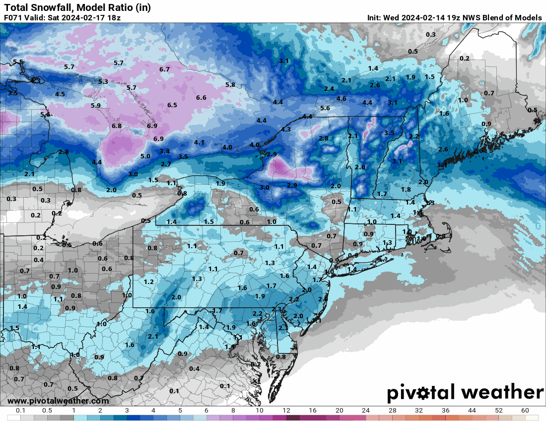
2 hours ago, snowwors2 said:
That N”BM” model was pretty crappy for last event, wasn’t it⁉️
It nailed the city but was a little low for the northern fringes of the CWA. It's not really a model per se but blends the MOS data from the main models and then gets some other ancillary data thrown in. I've noticed that whenever we get NAM'd, it just cancels that mess out until the NAM settles down.

-
-
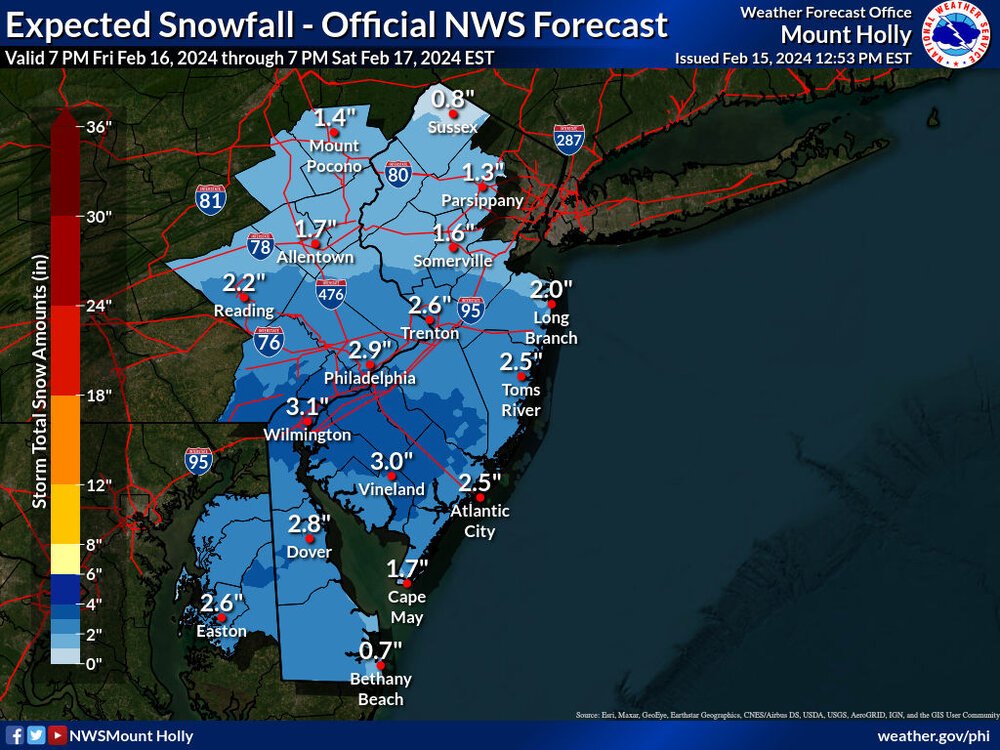
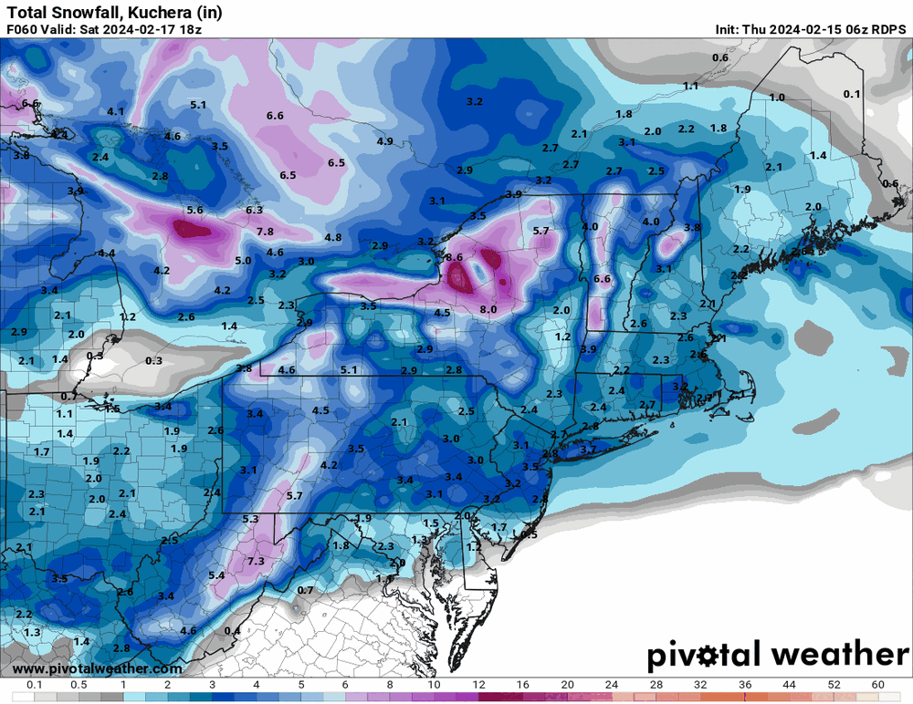
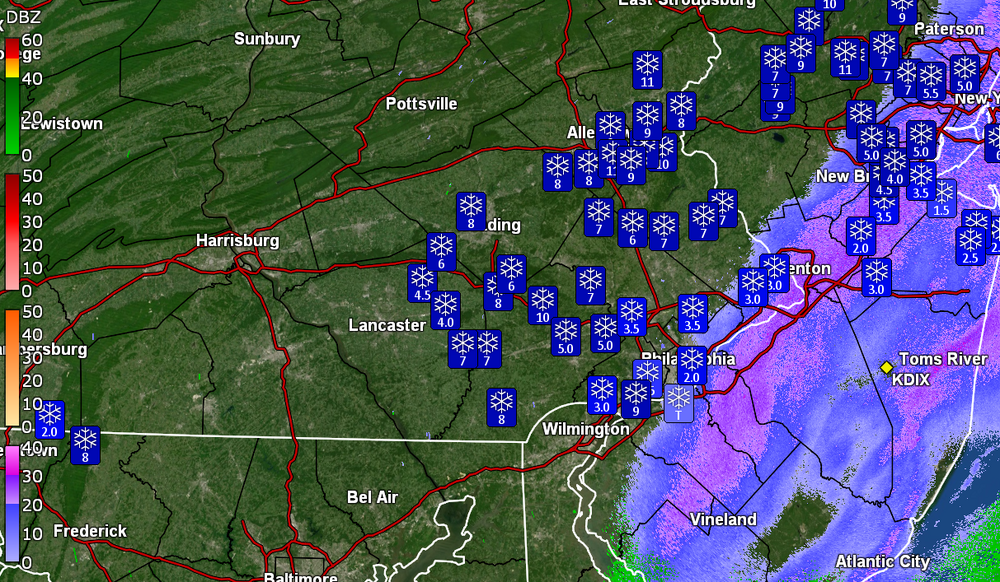
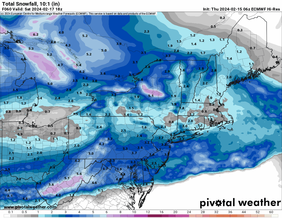
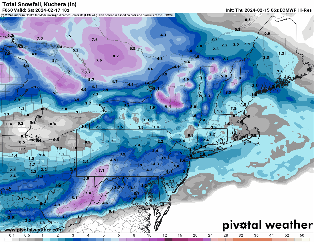
Mt. Holly 1 pm snow map -
-
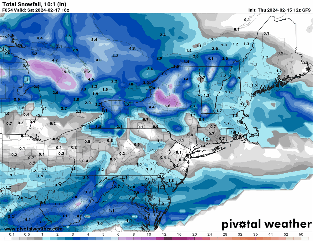
12z GFS definitely shows that "south" thing...
-
Bottomed out at 24 this morning but am only at 34 at near 11 am so am wondering if it will really warm up much. Dp has been hanging in the dry teens but finally hit 20. The cirrus has moved in although the sun is still breaking through it.
-
6z Canadian is similar to the NAM although it shows more across the northern areas.
-
LOL Looks like the 6z Euro NAM'd us.


-
 1
1
-
-
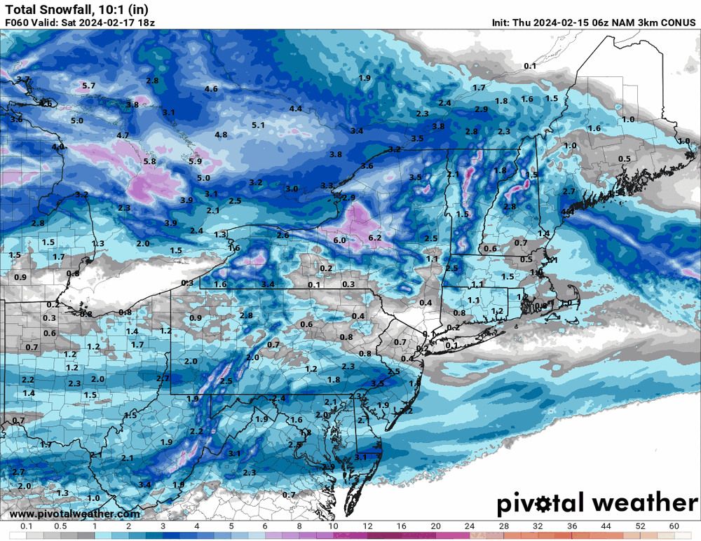
6z EC is running but here is the 6z 3k NAM that is now in range.
-
Throwing the 19z NBM in for Friday night/Saturday morning.
As an obs - I actually managed to stay above freezing all night and then finally dropped to 31 for a "low" at 9 am this morning. Was actually surprised at the temps as I expected to get higher today but nope. High ended up at 36 with a chilly breeze to boot. Lots of snow melt on roofs and streets/walks but parking lot mounds that were still around from the last storm, got a complete refresh.
When I was out today I noticed there was a "haze" of very high clouds that the sun was blazing through.
In any case, am currently 35 with an arctic-like dp of 13.
-
1
-
-
1 hour ago, Birds~69 said:
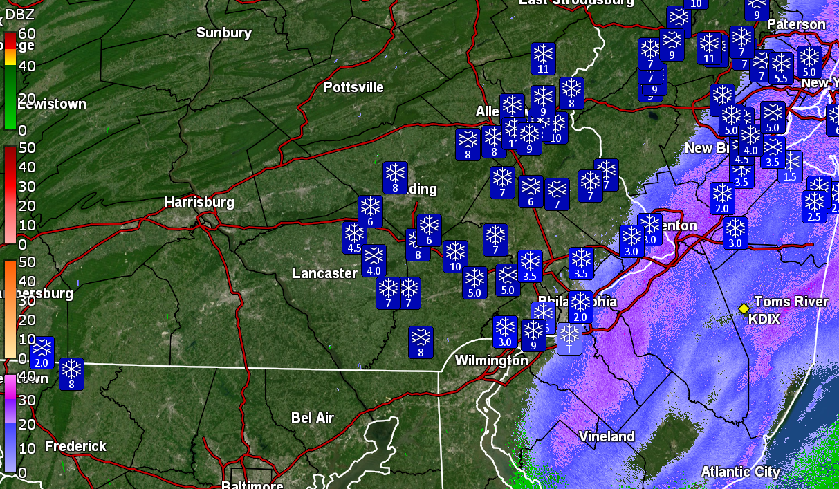
Do you know (or anyone) if the official Philly totals still come from the airport?
They used to do measurements from National Park, NJ but I have noticed in the PNS's that they are using an ASOS.
QuotePhiladelphia International 0.6 in 0100 PM 02/13 ASOS
The full PNS -
Quote000
NOUS41 KPHI 132119
PNSPHI
DEZ001>004-MDZ012-015-019-020-NJZ001-007>010-012>027-PAZ054-055-060>062-070-
071-101>106-140919-
Public Information Statement
National Weather Service Mount Holly NJ
419 PM EST Tue Feb 13 2024
...FINAL SNOWFALL TOTALS FOR 2/13/24 STORM...
Location Amount Time/Date Provider
...Delaware...
...New Castle County...
Winterthur 2.2 in 1200 PM 02/13 Mesonet
Hockessin 2.0 in 1200 PM 02/13 Mesonet
1 SW West Park 0.7 in 1200 PM 02/13 Mesonet
1 E Ashbourne Hills 0.6 in 1200 PM 02/13 Mesonet
New Castle County Airport 0.5 in 0100 PM 02/13 ASOS
...New Jersey...
...Atlantic County...
Atlantic City International T in 0100 PM 02/13 ASOS
...Burlington County...
1 ESE Delran 2.1 in 1100 AM 02/13 Trained Spotter
Maple Shade 1.9 in 1230 PM 02/13 Trained Spotter
1 NNE Rancocas 1.6 in 1215 PM 02/13 NWS Employee
Mount Holly WFO 1.4 in 1225 PM 02/13 Official NWS Obs
Mount Laurel 1.4 in 1240 PM 02/13 Trained Spotter
Medford 1.0 in 1140 AM 02/13 NWS Employee
Moorestown 1.0 in 0115 PM 02/13 Broadcast Media
Marlton 0.9 in 0945 AM 02/13 Trained Spotter
Leisuretowne 0.8 in 1225 PM 02/13 Trained Spotter
...Camden County...
1 W Greentree 1.5 in 1130 AM 02/13 Public
Mount Ephraim 0.9 in 1210 PM 02/13 COCORAHS
...Gloucester County...
Paulsboro 1.1 in 1145 AM 02/13 Public
Wenonah 0.2 SW 0.5 in 0912 AM 02/13 COCORAHS
...Hunterdon County...
2 SW Tewksbury Twp 8.0 in 1230 PM 02/13 Public
Flemington 7.6 in 1200 PM 02/13 Trained Spotter
Readington Twp 7.5 in 1000 AM 02/13 Trained Spotter
Flemington 1.9 SE 7.0 in 1200 PM 02/13 COCORAHS
Readington 6.5 in 1231 PM 02/13 Trained Spotter
Clinton Twp. 4 N 6.0 in 0830 AM 02/13 COCORAHS
Bloomsbury 5.0 in 0145 PM 02/13 Public
Glen Gardner 4.9 in 0650 AM 02/13 Public
...Mercer County...
Woodsville 6.8 in 1233 PM 02/13 Trained Spotter
Princeton 4.5 in 1236 PM 02/13 Trained Spotter
Trenton Mercer Airport 4.2 in 0100 PM 02/13 ASOS
Hopewell Twp. 2.4 NW 4.0 in 0909 AM 02/13 COCORAHS
Ewing 2.3 in 0935 AM 02/13 Trained Spotter
Hamilton Square 1.4 in 1237 PM 02/13 Trained Spotter
...Middlesex County...
Metuchen 6.1 in 1230 PM 02/13 Public
South Plainfield 5.5 in 1100 AM 02/13 Amateur Radio
Iselin 5.0 in 1240 PM 02/13 Trained Spotter
Highland Park 4.5 in 1100 AM 02/13 Amateur Radio
Edison 4.3 in 1238 PM 02/13 Trained Spotter
1 W North Brunswick 4.3 in 0100 PM 02/13 Public
New Brunswick 3 SE 4.0 in 0800 AM 02/13 COOP
1 ESE Kendall Park 4.0 in 1220 PM 02/13 Public
North Brunswick 4.0 in 1215 PM 02/13 Public
East Brunswick 3.6 in 1100 AM 02/13 Amateur Radio
South Amboy 3.5 in 1100 AM 02/13 Amateur Radio
Cranbury 2.7 in 1220 PM 02/13 Other Federal
...Monmouth County...
1 SSW Freehold 5.1 in 1250 PM 02/13 Trained Spotter
Holmdel 5.0 in 0130 PM 02/13 Trained Spotter
3 NE Perrineville 4.2 in 0130 PM 02/13 Trained Spotter
Middletown 4.0 in 1230 PM 02/13 Public
1 ENE Atlantic Highlands 3.5 in 0100 PM 02/13 Public
1 NNW Clarksburg 3.3 in 1240 PM 02/13 Cocorahs
Tinton Falls 3.2 in 0100 PM 02/13 Broadcast Media
1 N Colts Neck Twp 3.1 in 0120 PM 02/13 Cocorahs
Union Beach 2.1 SSE 3.0 in 0800 AM 02/13 COCORAHS
Marlboro 2.5 in 0900 AM 02/13 COOP
Monmouth Beach 2.2 in 1105 AM 02/13 Public
Little Silver 0.3 NNW 2.1 in 0900 AM 02/13 COCORAHS
2 SSE Howell 2.0 in 0100 PM 02/13 Cocorahs
Red Bank 2.0 in 1110 AM 02/13 Public
Keyport 1.5 in 1050 AM 02/13 Trained Spotter
Manasquan 1.2 in 1012 AM 02/13 CO-OP Observer
...Morris County...
Green Pond 11.5 in 0130 PM 02/13 Trained Spotter
Randolph Twp 2.2 SE 11.5 in 1137 AM 02/13 COCORAHS
Randolph 11.5 in 1136 AM 02/13 Trained Spotter
Denville 10.2 in 1210 PM 02/13 Trained Spotter
Kinnelon 1.4 SE 10.0 in 1000 AM 02/13 COCORAHS
Budd Lake 9.2 in 1120 AM 02/13 Public
Lake Hopatcong 9.2 in 1130 AM 02/13 Trained Spotter
1 WSW Milton 9.1 in 0145 PM 02/13 Trained Spotter
Morris Plains 9.1 in 1200 PM 02/13 Public
Butler 9.0 in 1120 AM 02/13 Trained Spotter
2 NNE Califon 9.0 in 1107 AM 02/13 Trained Spotter
Mount Arlington 8.5 in 0100 PM 02/13 Trained Spotter
Montville 8.0 in 0200 PM 02/13 Public
Roxbury Twp. 8.0 in 0700 AM 02/13 COCORAHS
1 WSW Mountain Lakes 8.0 in 1206 PM 02/13 Cocorahs
Rockaway 8.0 in 0100 PM 02/13 Trained Spotter
Chatham 7.8 in 0100 PM 02/13 Public
Whippany 7.5 in 1100 AM 02/13 Trained Spotter
2 SW Schooleys Mountain 7.3 in 1110 AM 02/13 Public
Pequannock 7.0 in 1200 PM 02/13 Trained Spotter
Parsippany-Troy Hills Twp 7.0 in 1120 AM 02/13 Public
Millington 6.9 in 1110 AM 02/13 Public
Boonton 6.0 in 1015 AM 02/13 Public
Ledgewood 6.0 in 0902 AM 02/13 Public
Pompton Plains 6.0 in 1010 AM 02/13 Public
...Ocean County...
2 NE Brick 1.7 in 0100 PM 02/13 Trained Spotter
...Somerset County...
Watchung 1.4 WNW 8.5 in 1145 AM 02/13 COCORAHS
3 W Belle Mead 8.3 in 1152 AM 02/13 Public
Far Hills 1 S 7.5 in 1200 PM 02/13 COCORAHS
Basking Ridge 7.3 in 1207 PM 02/13 Trained Spotter
3 SSE Far Hills 7.0 in 0100 PM 02/13 Public
Martinsville 7.0 in 1230 PM 02/13 Public
Hillsborough Twp 6.5 in 1235 PM 02/13 Trained Spotter
North Plainfield 6.2 in 1215 PM 02/13 Trained Spotter
Neshanic Station 6.0 in 1145 AM 02/13 Public
2 N Bridgewater 5.5 in 0100 PM 02/13 Cocorahs
2 ENE Montgomery Twp 5.3 in 1200 PM 02/13 Trained Spotter
Green Brook Twp 5.0 in 1130 AM 02/13 Trained Spotter
Middlebush 4.5 in 1230 PM 02/13 Cocorahs
Franklin Twp 3.8 ENE 4.1 in 0900 AM 02/13 COCORAHS
Millstone 3.0 in 1034 AM 02/13 Broadcast Media
...Sussex County...
Sussex 15.0 in 1228 PM 02/13 Trained Spotter
1 SSE Montague 14.8 in 0218 PM 02/13
Hampton Twp 13.0 in 0935 AM 02/13 Trained Spotter
Sparta 12.5 in 0930 AM 02/13 Trained Spotter
Sandyston Twp 12.3 in 1200 PM 02/13 Public
Vernon 12.1 in 1130 AM 02/13 Public
Ogdensburg 11.7 in 0100 PM 02/13 Public
Wantage Twp 11.6 in 1100 AM 02/13 Public
3 SSW High Point 11.3 in 1045 AM 02/13 Trained Spotter
Lafayette Twp 11.0 in 1105 AM 02/13 Trained Spotter
Newton 11.0 in 1200 PM 02/13 Public
3 N Pellettown 11.0 in 1045 AM 02/13 Trained Spotter
1 SSW Hamburg 10.7 in 1240 PM 02/13 Public
1 S Hardyston Twp 9.9 in 1130 AM 02/13 Cocorahs
Franklin 9.5 in 1100 AM 02/13 Public
Byram Twp 9.0 in 1050 AM 02/13 Public
Hopatcong 8.5 in 1208 PM 02/13 Trained Spotter
...Warren County...
Blairstown 12.0 in 1045 AM 02/13 Cocorahs
2 SE Knowlton Twp 10.4 in 1045 AM 02/13 Cocorahs
1 SSW Harmony 9.8 in 1100 AM 02/13 Trained Spotter
Knowlton Twp 1.7 S 9.8 in 0845 AM 02/13 COCORAHS
Hackettstown 9.0 in 1030 AM 02/13 Trained Spotter
Liberty Twp 8.5 in 1130 AM 02/13 Public
1 ENE Pohatcong Twp 8.3 in 1159 AM 02/13 Cocorahs
Washington Twp. 1.8 SE 8.0 in 1200 PM 02/13 COCORAHS
Phillipsburg 8.0 in 1100 AM 02/13 Public
Stewartsville 8.0 in 1030 AM 02/13 Trained Spotter
...Pennsylvania...
...Berks County...
Huffs Church 9.4 in 1037 AM 02/13 Trained Spotter
Hamburg 8.8 in 1015 AM 02/13 Public
Fleetwood 4.8 ESE 8.3 in 0700 AM 02/13 COCORAHS
Bern Twp 8.2 in 1134 AM 02/13 Trained Spotter
Blandon 8.1 in 1020 AM 02/13 Public
Lenhartsville 8.0 in 1024 AM 02/13 Public
Mertztown 8.0 in 1101 AM 02/13 Trained Spotter
Morgantown 8.0 in 1109 AM 02/13 Trained Spotter
Wernersville 8.0 in 1200 PM 02/13 Trained Spotter
Mohrsville 2.2 SW 6.8 in 0800 AM 02/13 COCORAHS
1 N Union Twp 6.8 in 1004 AM 02/13 Public
Spring Twp 6.5 in 1000 AM 02/13 Public
Elverson 2.1 NE 6.0 in 1100 AM 02/13 COCORAHS
3 ENE New Morgan 6.0 in 1114 AM 02/13 Trained Spotter
Reading Regional Airport 5.8 in 0100 PM 02/13 ASOS
1 N Boyertown 5.3 in 0829 AM 02/13 Public
1 WSW Douglass Twp 5.0 in 0830 AM 02/13 COCORAHS
...Bucks County...
2 NE Springtown 10.5 in 1100 AM 02/13 CO-OP Observer
East Rockhill Twp 8.9 in 1155 AM 02/13 Trained Spotter
2 E Telford 8.9 in 1030 AM 02/13 Cocorahs
Hilltown Twp 7.9 in 1115 AM 02/13 Trained Spotter
Lumberville 7.3 in 1110 AM 02/13 Trained Spotter
Bedminster 7.0 in 1241 PM 02/13 Trained Spotter
Buckingham Twp 7.0 in 0100 PM 02/13 Public
Gardenville 7.0 in 1123 AM 02/13 Trained Spotter
Trumbauersville 7.0 in 1030 AM 02/13 Trained Spotter
Doylestown 3.4 SW 6.5 in 1200 PM 02/13 COCORAHS
Furlong 6.0 in 1220 PM 02/13 Trained Spotter
Perkasie 0.8 NE 5.5 in 0900 AM 02/13 COCORAHS
Warminster 5.5 in 1030 AM 02/13 Trained Spotter
New Hope 5.0 in 1200 PM 02/13 Public
Lower Makefield Twp 4.8 in 0135 PM 02/13 Public
Bensalem 3.1 in 0100 PM 02/13 Public
Langhorne 3.0 in 1137 AM 02/13 Trained Spotter
1 SSE Northampton Twp 3.0 in 1045 AM 02/13 NWS Employee
...Carbon County...
Albrightsville 14.5 in 1000 AM 02/13 Public
Jim Thorpe 13.4 in 1030 AM 02/13 Trained Spotter
Lehighton 1.3 SSE 12.3 in 1200 PM 02/13 COCORAHS
Lehigh Twp 11.0 in 0850 AM 02/13 Trained Spotter
Lower Towamensing Twp 10.8 in 1030 AM 02/13 Public
Palmerton 7.0 in 0830 AM 02/13 Trained Spotter
...Chester County...
East Nantmeal Twp 10.5 in 1059 AM 02/13 Trained Spotter
West Caln Twp 9.3 in 1030 AM 02/13 Trained Spotter
2 E Warwick Twp 8.0 in 1200 PM 02/13 Mesonet
1 S Wallace Twp 7.8 in 1200 PM 02/13 Mesonet
1 E West Sadsbury Twp 7.5 in 1113 AM 02/13 Trained Spotter
1 NE East Vincent Twp 7.1 in 0100 PM 02/13 CO-OP Observer
East Coventry Twp 7.0 in 1150 AM 02/13 Trained Spotter
Glenmoore 7.0 in 0945 AM 02/13 Public
Malvern 7.0 in 1140 AM 02/13 Public
1 S Chester Springs 6.4 in 1200 PM 02/13 Mesonet
Easttown Twp 6.3 in 1130 AM 02/13 Public
1 WNW Chesterbrook 6.2 in 1115 AM 02/13 Trained Spotter
2 SSW Atglen 6.1 in 1200 PM 02/13 Mesonet
Downington 5.5 in 1230 PM 02/13 Public
Exton 5.3 in 1100 AM 02/13 Public
Paoli 5.2 in 1115 AM 02/13 Trained Spotter
West Bradford Twp 5.1 in 1240 PM 02/13 Trained Spotter
1 WSW Phoenixville 4.8 in 1137 AM 02/13 Trained Spotter
Exton 2.1 SE 4.6 in 0929 AM 02/13 COCORAHS
Jennersville 4.2 in 1120 AM 02/13 Public
1 W West Nottingham Twp 4.1 in 1200 PM 02/13 Mesonet
Oxford 4.0 in 0825 AM 02/13 Public
1 NNW Glenhall 3.9 in 1200 PM 02/13 Mesonet
Schuylkill Twp 3.6 in 0200 PM 02/13 Public
1 NNW Westtown 3.2 in 1200 PM 02/13 Mesonet
...Delaware County...
Thornton 4.3 in 1130 AM 02/13 Trained Spotter
Thornbury Twp 4.0 in 1106 AM 02/13 Public
Chadds Ford Twp 3.4 in 1100 AM 02/13 Trained Spotter
Bethel Twp 3.0 in 1119 AM 02/13 Public
Aston Twp. 2.0 in 1200 PM 02/13 Public
Morton 1.5 in 1110 AM 02/13 Trained Spotter
...Lehigh County...
Washington Twp 12.3 in 1250 PM 02/13 Trained Spotter
Weisenberg Twp 12.3 in 1005 AM 02/13 Public
Salisbury Twp 11.2 in 1103 AM 02/13 Trained Spotter
Germansville 10.8 in 1030 AM 02/13 Trained Spotter
3 E Zionsville 10.5 in 1140 AM 02/13 Public
3 W Upper Macungie Twp. 10.5 in 1200 PM 02/13 Trained Spotter
Center Valley 10.5 in 1100 AM 02/13 Trained Spotter
Allentown 9.5 in 1030 AM 02/13 Public
New Tripoli 9.3 in 1010 AM 02/13 Trained Spotter
1 ESE North Whitehall Twp 9.3 in 0120 PM 02/13 Cocorahs
Whitehall Twp 9.3 in 1100 AM 02/13 Trained Spotter
Lehigh Valley International 9.1 in 0100 PM 02/13 ASOS
Breinigsville 9.0 in 0930 AM 02/13 Trained Spotter
Coplay 9.0 in 1200 PM 02/13 Public
Emmaus 9.0 in 1100 AM 02/13 Trained Spotter
Macungie 8.8 in 1057 AM 02/13 Trained Spotter
Wescosville 0.3 SE 8.5 in 1230 PM 02/13 COCORAHS
1 WSW Neffs 8.5 in 0100 PM 02/13 Trained Spotter
2 NE Ancient Oaks 8.5 in 1240 PM 02/13 Cocorahs
...Monroe County...
1 NNW Pocono Summit 14.5 in 0130 PM 02/13 Trained Spotter
Tobyhanna 14.5 in 0900 AM 02/13 Public
Stroudsburg 13.2 in 1030 AM 02/13 CO-OP Observer
Effort 13.0 in 1130 AM 02/13 Public
4 NNW Echo Lake 13.0 in 1045 AM 02/13 Public
Sciota 13.0 in 1159 AM 02/13 Trained Spotter
Arlington Heights 12.5 in 1031 AM 02/13 Trained Spotter
Coolbaugh Twp 12.3 in 1206 PM 02/13 Trained Spotter
Pocono Pines 12.2 in 0909 AM 02/13 Trained Spotter
Paradise Valley 12.0 in 1200 PM 02/13 Public
Canadensis 12.0 in 0700 AM 02/13 COOP
2 NW Blakeslee 11.8 in 0140 PM 02/13 Trained Spotter
2 NNW Pocono Mountains Munic 11.5 in 0210 PM 02/13
Mount Pocono 0.7 N 10.5 in 0700 AM 02/13 COCORAHS
Mount Pocono 9.7 in 0635 AM 02/13 Trained Spotter
...Montgomery County...
Schwenksville 9.0 in 1030 AM 02/13 Public
3 NW Trappe 8.8 in 1220 PM 02/13 Trained Spotter
Souderton 8.5 in 1045 AM 02/13 Trained Spotter
New Hanover Twp 8.2 in 1030 AM 02/13 Trained Spotter
Upper Hanover Twp 8.1 in 0950 AM 02/13 Trained Spotter
1 SW Lansdale 8.0 in 1145 AM 02/13 Trained Spotter
2 SW Pennsburg 7.5 in 1100 AM 02/13 Public
Pottstown 7.5 in 1000 AM 02/13 Public
Royersford 7.5 in 1115 AM 02/13 Trained Spotter
Salford Twp 6.7 in 1100 AM 02/13 Public
Eagleville 5.5 in 1000 AM 02/13 Trained Spotter
Norristown 5.3 in 1204 PM 02/13 Trained Spotter
Upper Providence Twp 5.3 in 1030 AM 02/13 Emergency Mngr
Hatfield 5.0 in 0100 PM 02/13 Public
2 S Horsham Twp 4.5 in 1157 AM 02/13 Trained Spotter
King of Prussia 4.3 in 1230 PM 02/13 Trained Spotter
Glenside 3.8 in 1122 AM 02/13 Trained Spotter
Wyndmoor 3.2 in 0952 AM 02/13 Trained Spotter
Penn Wynne 3.0 in 1230 PM 02/13 Cocorahs
...Northampton County...
Bangor 12.0 in 1030 AM 02/13 Trained Spotter
Bushkill Twp 11.0 in 1005 AM 02/13 Trained Spotter
Bethlehem 10.5 in 1033 AM 02/13 Trained Spotter
Nazareth 10.3 in 0950 AM 02/13 Public
Forks Twp 10.1 in 1230 PM 02/13 Public
Pen Argyl 10.0 in 1042 AM 02/13 Trained Spotter
Moore Twp 9.7 in 1045 AM 02/13 Public
2 E Bethlehem 9.5 in 1207 PM 02/13 Trained Spotter
Palmer Heights 9.1 in 0157 PM 02/13 Trained Spotter
Bethlehem Twp 9.1 in 1128 AM 02/13 Trained Spotter
Martins Creek 9.1 in 0100 PM 02/13 CO-OP Observer
Hellertown 8.4 in 1100 AM 02/13 Trained Spotter
Walnutport 7.5 in 0815 AM 02/13 Trained Spotter
...Philadelphia County...
Shawmont 4.5 in 1200 PM 02/13 Trained Spotter
1 NNW Manayunk 3.5 in 0100 PM 02/13 Public
Philadelphia 1.0 in 0900 AM 02/13 COCORAHS
Mantua 1.0 in 1205 PM 02/13 Public
Philadelphia International 0.6 in 0100 PM 02/13 ASOS
&&Well my "high" for the day was 40 at midnight, but after the storm was done and the sun came out, I did get close, hitting around 38 briefly.
It's currently 36 with dp 29.
-
1
-
-
Sun is out and melting is underway. Temp now up to 35 with dp 35.
-
And the sun has started to pop out. Temp now up to 35 with dp 35 and dripping.
-
That thing hopped an express train and is booking it outta here.
-
The back edge is now past me and I'm down to flurries.
Final measurement at 11:45 am was 3.5" (so got 1" over the 3 hours since the earlier measurement).
Currently have some stray flurries and it's 33 with dp 33 and all kinds of melting and sloughing going on. Am hoping more can slough off the car the rest of today.
-
19 minutes ago, RedSky said:
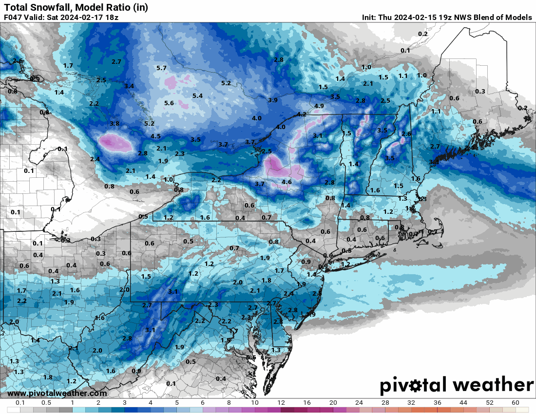
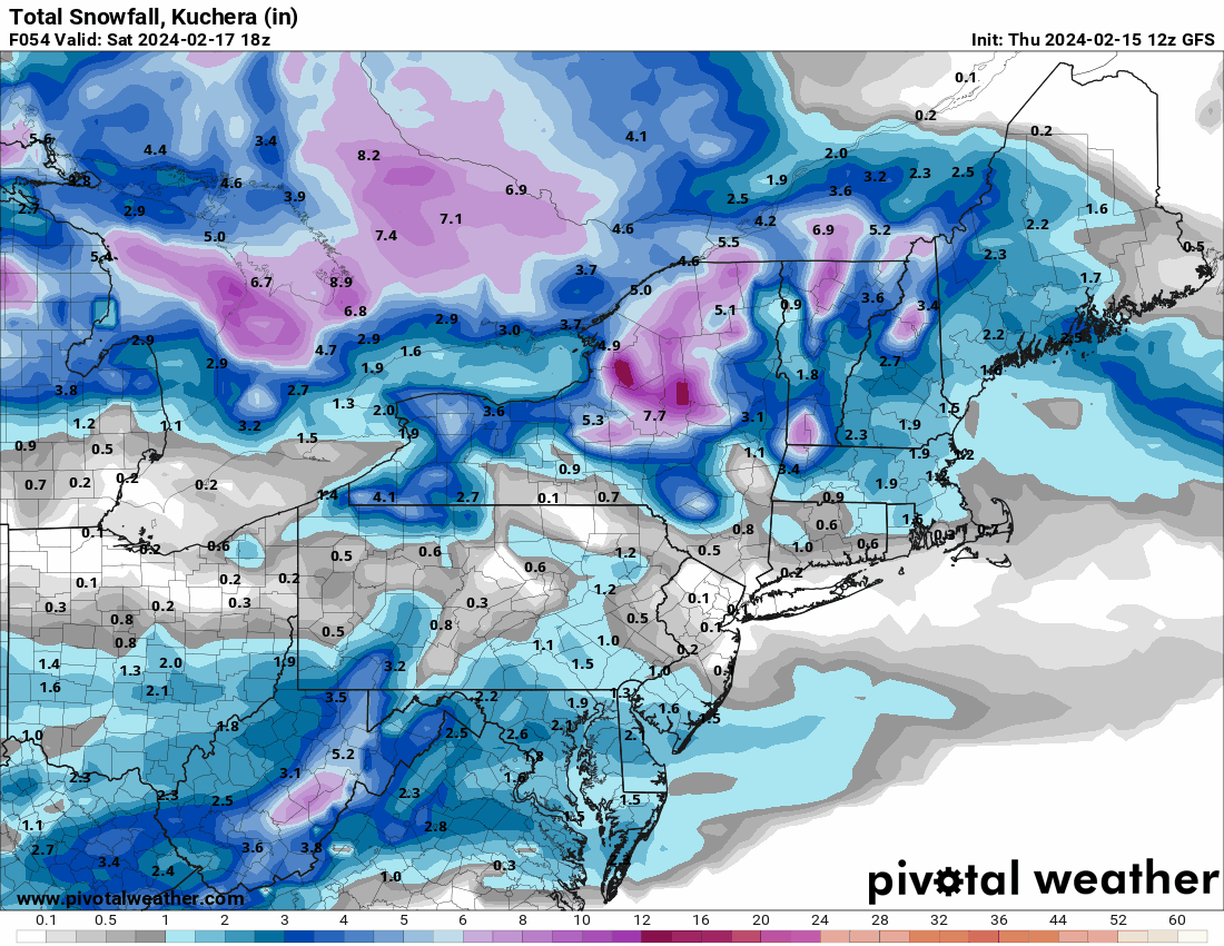
The ICON trying for redemption this Saturday with 2-4"
* make that 3-5"
One of my nieces has an 18th birthday this weekend (Sunday) and she wanted to do a restaurant out in KOP on Saturday. Was hoping to squeak by without precip. although my BIL is gonna drive (I'm not about to get lost out there
 ).
).
My lowest bottom out this morning was 32.2 at around 7:15 am, the storm has pivoted past me now, and I'm down to flurries. Gonna go out and get the last measurement before it melts/compacts more.
Currently have flurries and it's 33 with dp 33.
-
1
-
-
3 hours ago, jwilson said:
I was obsessed with the original when I was 10 - went to see it in the theater at least three times and then burned through a VHS copy. A big reason I got into tornadoes and weather was because of that movie.
Obviously the science doesn't hold up at all, and I imagine this sequel won't be any better in that regard, but it's a trip.
I got into them thanks to a book that I ordered with the monthly book order thing they did while I was in middle school!
1 hour ago, JTA66 said:I'm old, that's how I felt about The Wizard of Oz as a kid
My mom was 9 when that came out and she said her generation was enamored by the fact that half the film was "in color". Hell many of us grew up with TV shows that had the opening of "in color" on the screen to let you know that the show was actually "in color" (if you even had a color TV).

-
1
-
-
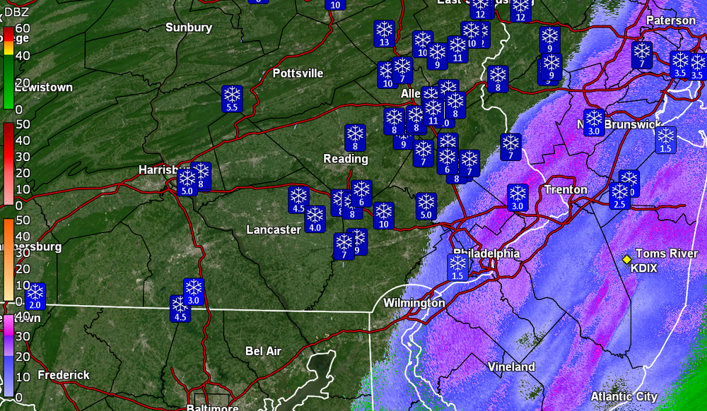
Have been under one of the stronger pivot bands with some SN+ and pancake flakes. Back edge is approaching though.
Temp 33 with dp 32.
33 minutes ago, JTA66 said:Looks like it's trying to develop an eye

Dug a quick path to the car and shoved out the base of the driveway before the plows come through, didn't want to do that all at once. I can confirm: heart attack snow.
That sucker wants to bomb out!
-
You can see how/where it will pivot.
-
3
-
-
Still getting moderate snow here although not at the 1"/hr rate (probably closer to 1/3rd - 1/2" per hr).
Temp is up to 33 with dp 32.
-
Just now, RedSky said:
First observation is I slept through all the good stuff. Looking at radar the snow will be ending early in another hour still coming down moderately. Looks like between 5-6".
Yeti has awoken!

I still think you are in the pivot area.
-
2
-
-
Looks like Central Montco & Bucks up into Hunterdon county, NJ and NE, are are in the pivot zone. My cousin up in West Orange, NJ (Essex County) just texted pics of the snow up her way.
-
1
-
-
Still have SN but smaller flakes/lighter intensity.
Did measure the board about 8:45 am and have 2.5". The transition started about 6:30 with pingers mixing with rain, then white rain, and by 6:50, it was full on snow. So this averaged a bit over 1"/hr rates.
Temp has been holding right at 32 with dp 32.
-
Was briefly under a heavier streak and getting fatties mixed in. It's wet stuff too that has plastered the trees and shrubs and although it looks pretty, it could cause some concerns with power lines if the winds really pick up. Am watching the pivot.
Currently SN (vis is up now) and 32 with dp 32.
-
1
-
-
KYW's Jim Melwert reported that he was on Rt. 29 (and a notorious hill), near 422 and traffic is stuck.
-
1
-


E PA/NJ/DE Winter 2023-2024 OBS/Discussion
in Philadelphia Region
Posted
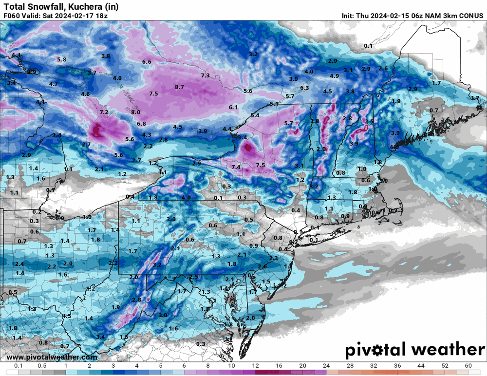
6z 3k NAM