

Hurricane Agnes
-
Posts
8,581 -
Joined
Content Type
Profiles
Blogs
Forums
American Weather
Media Demo
Store
Gallery
Posts posted by Hurricane Agnes
-
-
Wanted to wait until after sunrise this morning to confirm but my low this morning was 20. And although the winds relaxed after about 6 pm last night, they never went calm, and there were puffs of a breeze on and off all night, so the ideal radiational cooling wasn't in effect.
Currently mostly sunny and 23 with dp 16.
-
Bottomed out at 20 this morning and made it up to just under freezing with a high of 31. The wind was blowing a lot of the powder off the roofs in the area in any case. I also noticed that some time after noon yesterday, my station's anemometer and vane managed to free themselves from their frozen encasement and were moving again.
Currently clear and 29 with dp 14 and I expect the radiational cooling will be in full effect tonight.
-
49 minutes ago, KamuSnow said:
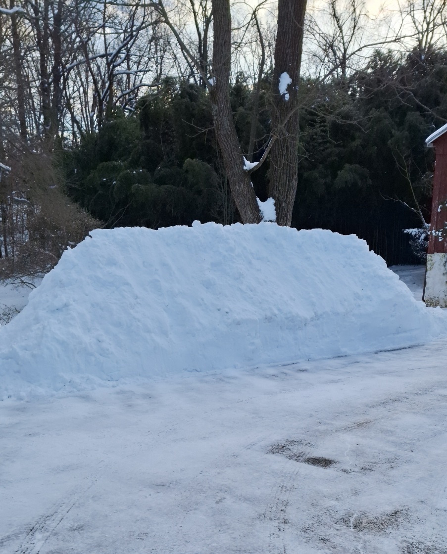
Finished shoveling late yesterday, got a nice snowpile together! (Been a couple of years). Let's see if it can survive the upcoming thaw.
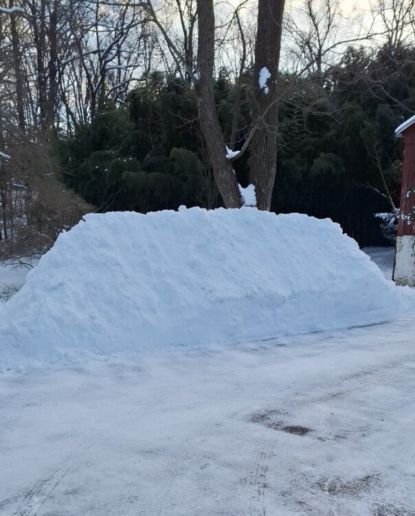
OMG it's been a LONG time since we've seen the epic snow pile at your spot!

As powdery stuff, six on one side says it would go quickly and a dozen on the other says if there is some rain in there with melting and refreezing, the potential for glacier creation would be there to help build a solid foundation.

So far today (and probably the final) my "high" for the day was 23 at midnight as I got no higher than 22 during the daytime hours.
It's currently partly sunny but with a high cloud deck moving in, and 22 with dp 9.
-
 1
1
-
 1
1
-
-
Bottomed out at 17 this morning and did the initial car clearing. Thankfully that was some powdery stuff (compared to the powder from the earlier storm that had a 1/4" crust of ice on it
 ), so was able to clear most of it pretty quickly.
The winds have picked up so the snow is now blowing around. Currently a sunny but chilly 21 with dp 10.
-
1
-
-
I did a double-check earlier this morning to see if any amounts changed after my last 4.25" measurement around 5 pm yesterday, and it didn't, so am going with that.
Just came in from removing the snow from the car and thankfully it is some really powdery stuff. I saw the winds had started to pick up so figured better get it done now since it's also blowing around, and that would aid getting leftovers off the roof (have a big SUV).
Currently breezy and sunny, with lots of cumulus, and 21, with dp an arctic 10.
-
10 pm Jan. 19, 2024 PNS -
Quote000
NOUS41 KPHI 200306
PNSPHI
DEZ001>004-MDZ012-015-019-020-NJZ001-007>010-012>027-PAZ054-055-060>062-070-
071-101>106-201506-
Public Information Statement
National Weather Service Mount Holly NJ
1006 PM EST Fri Jan 19 2024
...SNOWFALL REPORTS AS OF 10 PM 1/19/24...
Location Amount Time/Date Provider
...Delaware...
...Kent County...
Dover 7.0 in 0553 PM 01/19 Public
Clayton 6.0 in 0155 PM 01/19 Public
2 S Clayton 6.0 in 0545 PM 01/19 Cocorahs
1 S Dover 6.0 in 0600 PM 01/19 Public
Smyrna 5.4 in 0944 PM 01/19 Public
2 S Smyrna Landing 5.3 in 0800 PM 01/19 Mesonet
4 S Hazlettville 5.1 in 0800 PM 01/19 Mesonet
West Dover 5.1 in 0800 PM 01/19 Mesonet
2 SE Dover 5.0 in 0800 PM 01/19 Mesonet
3 SW Magnolia 5.0 in 0600 PM 01/19 Trained Spotter
Cheswold 4.9 in 0500 PM 01/19 Public
2 SE Frederica 4.0 in 0800 PM 01/19 Mesonet
2 SSE Woodside 4.0 in 0206 PM 01/19 Trained Spotter
1 E Harrington 3.9 in 0800 PM 01/19 Mesonet
...New Castle County...
Middletown 6.0 in 0300 PM 01/19 Public
Delaware City 5.5 in 0500 PM 01/19 Public
Bear 5.5 in 0511 PM 01/19 Public
Stockton 5.3 in 0800 PM 01/19 Mesonet
Odessa 5.2 in 0615 PM 01/19 Trained Spotter
Monroe Park 5.1 in 0800 PM 01/19 Mesonet
New Castle County Airport 5.1 in 0700 PM 01/19 ASOS
1 E Ashbourne Hills 5.0 in 0800 PM 01/19 Mesonet
Middletown 5.0 in 0124 PM 01/19 Trained Spotter
1 E Glasgow 4.6 in 0800 PM 01/19 Mesonet
1 SW West Park 4.5 in 0800 PM 01/19 Mesonet
White Clay Creek 4.5 in 0800 PM 01/19 Mesonet
1 WNW Ashbourne Hills 4.3 in 0600 PM 01/19 Public
1 SSE Newark 4.2 in 0800 PM 01/19 Mesonet
Winterthur 4.2 in 0800 PM 01/19 Mesonet
Nottingham Manor 4.0 in 0300 PM 01/19 Public
1 NW Holiday Hills 4.0 in 0500 PM 01/19 Trained Spotter
Port Penn 3.9 in 0800 PM 01/19 Mesonet
Hockessin 3.6 in 0145 PM 01/19 Trained Spotter
...Sussex County...
Milford 5.0 in 0450 PM 01/19 Public
Milton 4.8 in 0340 PM 01/19 Broadcast Media
Ellendale 4.0 in 0800 PM 01/19 Mesonet
Bethel 4.0 in 0638 PM 01/19 Broadcast Media
Lincoln 3.5 in 0800 PM 01/19 Public
2 N Bridgeville 3.2 in 0800 PM 01/19 Mesonet
Seaford 3.2 in 0515 PM 01/19 Public
4 E Delmar 3.0 in 0700 PM 01/19 Cocorahs
Stockley 2.8 in 0800 PM 01/19 Mesonet
Georgetown 2.5 in 0600 PM 01/19 Trained Spotter
5 W Seaford 2.4 in 0800 PM 01/19 Mesonet
Nassau 2.4 in 0800 PM 01/19 Mesonet
2 SW Laurel 2.1 in 0800 PM 01/19 Mesonet
1 SE Dagsboro 2.0 in 0800 PM 01/19 Mesonet
...Maryland...
...Caroline County...
4 SSE Ingleside 5.5 in 0723 PM 01/19 Trained Spotter
...Kent County...
Millington 4.8 in 0436 PM 01/19 Broadcast Media
...Queen Annes County...
Centreville 6.0 in 0415 PM 01/19 Public
Barclay 5.6 in 0457 PM 01/19 Public
4 S Grasonville 5.5 in 0630 PM 01/19 Trained Spotter
Crumpton 4.6 in 0436 PM 01/19 Broadcast Media
...Talbot County...
1 NE Easton 4.0 in 0700 PM 01/19 Trained Spotter
...New Jersey...
...Atlantic County...
2 W Atlantic City 6.0 in 0728 PM 01/19 Public
Mullica Twp 5.6 in 0535 PM 01/19 Trained Spotter
Mays Landing 5.5 in 0550 PM 01/19 Public
1 NW Somers Point 5.2 in 0929 PM 01/19 Cocorahs
Absecon 5.0 in 0726 PM 01/19 Broadcast Media
2 WSW Richland 5.0 in 0200 PM 01/19 Public
1 S Atlantic City 5.0 in 0633 PM 01/19 Public
Atlantic City International 4.6 in 0700 PM 01/19 ASOS
1 N Hammonton 4.5 in 0500 PM 01/19 CO-OP Observer
Egg Harbor Twp. 4.4 in 0340 PM 01/19 Emergency Mngr
Smithville 4.3 in 0825 PM 01/19 Broadcast Media
1 WNW Hammonton 4.3 in 0518 PM 01/19 Cocorahs
Pomona 3.0 in 0200 PM 01/19 Broadcast Media
Somers Point 3.0 in 0245 PM 01/19 Broadcast Media
1 NNE Somers Point 2.6 in 0200 PM 01/19 Broadcast Media
Ventnor City 2.6 in 0200 PM 01/19 Broadcast Media
...Burlington County...
Medford Twp. 6.1 in 0718 PM 01/19 Trained Spotter
Tabernacle 6.0 in 0934 PM 01/19 Public
Mount Laurel 6.0 in 0530 PM 01/19 Trained Spotter
Moorestown 6.0 in 0616 PM 01/19 Trained Spotter
Medford Lakes 5.9 in 0614 PM 01/19 Public
Moorestown Twp 5.5 in 0515 PM 01/19 Trained Spotter
Medford 5.5 in 0530 PM 01/19 Public
Lake Pine 5.5 in 0600 PM 01/19 Trained Spotter
Marlton 5.3 in 0530 PM 01/19 Trained Spotter
Westampton Twp 5.2 in 0500 PM 01/19 Trained Spotter
Leisuretowne 5.1 in 0720 PM 01/19 Trained Spotter
2 NNW South Jersey Regional 5.0 in 0545 PM 01/19 CO-OP Observer
Evesham Twp 5.0 in 0651 PM 01/19 Trained Spotter
1 ESE Riverside 4.8 in 0830 PM 01/19 Public
Mount Holly WFO 4.8 in 0700 PM 01/19 Official NWS Obs
Palmyra 4.8 in 0545 PM 01/19 Public
2 NW South Jersey Regional A 4.3 in 0544 PM 01/19 NWS Employee
Delanco 4.1 in 0530 PM 01/19 Trained Spotter
Delran 4.0 in 0554 PM 01/19 Public
Browns Mills 4.0 in 0605 PM 01/19 Public
Columbus 4.0 in 0624 PM 01/19 Trained Spotter
...Camden County...
Blackwood 5.8 in 0545 PM 01/19 Public
Magnolia 5.5 in 0550 PM 01/19 Public
Lindenwold 5.5 in 0630 PM 01/19 Trained Spotter
Greentree 5.4 in 0700 PM 01/19 NWS Employee
Haddon Township 5.3 in 0630 PM 01/19 Trained Spotter
1 W Cherry Hill Twp 5.1 in 0718 PM 01/19 Public
2 NNW Winslow Twp 5.0 in 0700 PM 01/19 Amateur Radio
1 NNE Gibbsboro 5.0 in 0345 PM 01/19 Public
1 ENE Winslow Twp 5.0 in 0400 PM 01/19 Amateur Radio
Cherry Hill 5.0 in 0500 PM 01/19 Public
1 NNE Stratford 4.9 in 0430 PM 01/19 Trained Spotter
Atco 4.8 in 0700 PM 01/19 Amateur Radio
1 SSW Pine Hill 4.5 in 0700 PM 01/19 Trained Spotter
Bellmawr 4.5 in 0411 PM 01/19 Trained Spotter
2 SW Chesilhurst 4.0 in 0400 PM 01/19 Amateur Radio
...Cape May County...
Dennisville 4.9 in 0500 PM 01/19 Trained Spotter
Seaville 4.5 in 0500 PM 01/19 Trained Spotter
2 NNE Strathmere 4.5 in 0520 PM 01/19 Trained Spotter
Ocean City 4.4 in 0726 PM 01/19 Broadcast Media
Wildwood 4.0 in 0400 PM 01/19 Trained Spotter
2 NW Cape May 3.2 in 0820 PM 01/19 CO-OP Observer
1 SSW Cape May Court House 3.0 in 0450 PM 01/19 Trained Spotter
4 NW Avalon 3.0 in 0648 PM 01/19 Trained Spotter
1 SE Green Creek 3.0 in 0649 PM 01/19 Trained Spotter
...Cumberland County...
1 W Hopewell Twp. 6.5 in 0550 PM 01/19 Trained Spotter
1 NNW Port Norris 6.3 in 0630 PM 01/19 Trained Spotter
2 SSE Deerfield Twp 6.0 in 0600 PM 01/19 Amateur Radio
Vineland 5.9 in 0931 PM 01/19 Amateur Radio
Stow Creek Twp 5.3 in 0726 PM 01/19 Broadcast Media
Seabrook Farms 4.0 in 0600 PM 01/19 Public
...Gloucester County...
Mount Royal 6.5 in 0711 PM 01/19 Public
Malaga 6.0 in 0700 PM 01/19 Trained Spotter
1 NNW Franklinville 5.9 in 0904 PM 01/19 Trained Spotter
Glassboro 5.8 in 0600 PM 01/19 Public
Williamstown 5.8 in 0625 PM 01/19 Broadcast Media
Franklinville 5.5 in 0902 PM 01/19 Public
Gibbstown 5.5 in 0245 PM 01/19 Public
1 W Pitman 5.5 in 0445 PM 01/19 Public
Pitman 5.3 in 0630 PM 01/19 Trained Spotter
West Deptford Twp 5.1 in 0631 PM 01/19 Trained Spotter
Paulsboro 5.0 in 0530 PM 01/19 Public
Woodbury 5.0 in 0700 PM 01/19 Public
Washington Twp 4.6 in 0545 PM 01/19 Trained Spotter
1 SSE Mullica Hill 3.0 in 0140 PM 01/19 Trained Spotter
...Hunterdon County...
Flemington 2.6 in 0500 PM 01/19 Trained Spotter
1 NNW Three Bridges 1.8 in 0600 PM 01/19 Trained Spotter
...Mercer County...
Hamilton Twp 4.3 in 0530 PM 01/19 Trained Spotter
Woodsville 4.2 in 0400 PM 01/19 Trained Spotter
Robbinsville Twp. 4.1 in 0430 PM 01/19 Trained Spotter
2 SW Pennington 4.0 in 0250 PM 01/19 Public
Yardville 4.0 in 0351 PM 01/19 Public
1 N North Princeton 4.0 in 0430 PM 01/19 Trained Spotter
Lawrenceville 4.0 in 0440 PM 01/19 Public
1 NNE Hamilton Square 3.9 in 0530 PM 01/19 Trained Spotter
Hamilton Square 3.8 in 0200 PM 01/19 Public
Trenton Mercer Airport 3.6 in 0700 PM 01/19 ASOS
2 WNW Allentown 3.5 in 0315 PM 01/19 Public
1 SSE West Windsor Twp. 3.5 in 0500 PM 01/19 Trained Spotter
Mercerville 3.5 in 0530 PM 01/19 Trained Spotter
Lawrenceville 3.3 in 0115 PM 01/19 Trained Spotter
...Middlesex County...
2 NW South Brunswick 3.8 in 0420 PM 01/19 Public
1 ESE Kendall Park 3.8 in 0420 PM 01/19 Public
Cranbury 3.8 in 0521 PM 01/19 Other Federal
South River 3.3 in 0445 PM 01/19 Trained Spotter
Cheesequake 3.2 in 0550 PM 01/19 Trained Spotter
East Brunswick 3.0 in 0145 PM 01/19 Trained Spotter
Edison 2.8 in 0530 PM 01/19 Newspaper
Metuchen 2.7 in 0230 PM 01/19 Trained Spotter
Highland Park 2.7 in 0257 PM 01/19 Public
1 S Iselin 2.5 in 0456 PM 01/19 Trained Spotter
South Plainfield 1.0 in 0310 PM 01/19 Trained Spotter
...Monmouth County...
3 SE Freehold Twp 4.8 in 0607 PM 01/19 Public
Freehold 4.2 in 0427 PM 01/19 Trained Spotter
1 SW Howell 4.1 in 0540 PM 01/19 Trained Spotter
1 E Perrineville 4.0 in 0400 PM 01/19 Public
2 SSW Farmingdale 4.0 in 0425 PM 01/19 Public
1 NNW Neptune City 4.0 in 0737 PM 01/19 Trained Spotter
1 SW Long Branch 3.5 in 0900 PM 01/19 CO-OP Observer
1 SSW Freehold 3.0 in 0100 PM 01/19 Trained Spotter
Keyport 3.0 in 0700 PM 01/19 Public
Leonardo 2.5 in 0700 PM 01/19 Public
1 E Monmouth Hills 2.2 in 0515 PM 01/19 Public
...Morris County...
Green Pond 2.0 in 0630 PM 01/19 Trained Spotter
2 NNE Brookside 1.3 in 0400 PM 01/19 Trained Spotter
Butler 1.0 in 0315 PM 01/19 Trained Spotter
Chatham 0.8 in 0855 PM 01/19 Public
Pompton Plains 0.8 in 0513 PM 01/19 Public
...Ocean County...
Whiting 5.6 in 0519 PM 01/19 Public
2 NW Jackson 5.1 in 0700 PM 01/19 Trained Spotter
Tuckerton 4.0 in 0730 PM 01/19 Trained Spotter
Manahawkin 4.0 in 0500 PM 01/19 Trained Spotter
Lanoka Harbor 4.0 in 0615 PM 01/19 Trained Spotter
2 SE Forked River 3.8 in 0830 PM 01/19 Trained Spotter
Barnegat Twp 3.8 in 0615 PM 01/19 Trained Spotter
Little Egg Harbor Twp 3.5 in 0423 PM 01/19 Trained Spotter
Lacey Twp 3.5 in 0650 PM 01/19 Public
1 SSE Brick 3.4 in 0545 PM 01/19 Trained Spotter
2 ESE Ramtown 3.3 in 0500 PM 01/19 Public
Toms River 3.2 in 0732 PM 01/19 Trained Spotter
Point Pleasant 3.1 in 0700 PM 01/19 Public
Bayville 3.0 in 0739 PM 01/19 Trained Spotter
Beachwood 2.5 in 0921 PM 01/19 Public
Brick 2.5 in 0205 PM 01/19 Public
Beachwood 2.0 in 0200 PM 01/19 Public
Point Pleasant 2.0 in 0200 PM 01/19 Trained Spotter
Surf City 2.0 in 0330 PM 01/19 Public
1 SSE Stafford Twp. 1.0 in 1245 PM 01/19 Trained Spotter
...Salem County...
Woodstown 5.7 in 0751 PM 01/19 Trained Spotter
Elmer 5.0 in 0600 PM 01/19 Amateur Radio
...Somerset County...
Belle Mead 3.5 in 0412 PM 01/19 Trained Spotter
2 ENE Montgomery Twp 2.9 in 0500 PM 01/19 Trained Spotter
Kendall Park 2.5 in 0110 PM 01/19 Public
2 NNW Bridgewater 1.0 in 0700 PM 01/19 Trained Spotter
...Sussex County...
4 WSW Wantage Twp 2.5 in 0615 PM 01/19 Trained Spotter
3 ESE Montague 2.1 in 0600 PM 01/19 Trained Spotter
Wantage Twp 2.0 in 0815 PM 01/19 Public
Sussex 2.0 in 0525 PM 01/19 Public
...Warren County...
1 NNW Stewartsville 1.3 in 1245 PM 01/19 Trained Spotter
Hackettstown 1.2 in 0414 PM 01/19 Trained Spotter
Blairstown 0.7 in 1130 AM 01/19 Public
...Pennsylvania...
...Berks County...
Spring Twp 4.2 in 0630 PM 01/19 Public
1 N Union Twp 4.1 in 0250 PM 01/19 Public
Wernersville 4.0 in 0705 PM 01/19 Trained Spotter
Earl Twp 3.5 in 0400 PM 01/19 Trained Spotter
Union Twp 3.5 in 0450 PM 01/19 Public
Huffs Church 3.5 in 0645 PM 01/19 Public
Reading Regional Airport 3.5 in 0700 PM 01/19 ASOS
Bern Twp 3.3 in 0630 PM 01/19 Trained Spotter
1 ENE Blandon 3.0 in 0300 PM 01/19 Trained Spotter
1 N Lenhartsville 2.3 in 0530 PM 01/19 Public
Shillington 2.0 in 0930 AM 01/19 Public
...Bucks County...
New Hope 5.0 in 0545 PM 01/19 Trained Spotter
Bensalem 4.8 in 0730 PM 01/19 Public
1 SSE Northampton Twp 4.8 in 0845 PM 01/19 NWS Employee
Richboro 4.5 in 0330 PM 01/19 Public
Jamison 4.5 in 0615 PM 01/19 Public
Furlong 4.3 in 0730 PM 01/19 Public
Levittown 4.2 in 0230 PM 01/19 Trained Spotter
Newtown Grant 4.2 in 0449 PM 01/19 Trained Spotter
1 NNW Langhorne 4.2 in 0515 PM 01/19 Trained Spotter
Hilltown Twp 3.9 in 0700 PM 01/19 Trained Spotter
1 SSE Bristol Twp 3.8 in 0430 PM 01/19 Trained Spotter
Warminster 3.8 in 0400 PM 01/19 Trained Spotter
East Rockhill Twp 3.7 in 0430 PM 01/19 Trained Spotter
1 SW Lower Southampton Twp 3.5 in 1215 PM 01/19 Public
1 SSE Lumberville 3.3 in 0400 PM 01/19 Trained Spotter
1 SW Gardenville 3.0 in 1248 PM 01/19 Public
1 ESE Fricks 2.5 in 1100 AM 01/19 Trained Spotter
...Carbon County...
Hudsondale 1.9 in 0200 PM 01/19 Public
...Chester County...
Malvern 5.0 in 0654 PM 01/19 Public
Downington 5.0 in 0200 PM 01/19 Public
Lincoln University 5.0 in 0400 PM 01/19 Trained Spotter
Easttown Twp 4.5 in 0249 PM 01/19 Public
East Nantmeal Twp 4.5 in 0530 PM 01/19 Trained Spotter
East Coventry Twp 4.4 in 0440 PM 01/19 Trained Spotter
1 SW Westtown 4.2 in 0445 PM 01/19 Trained Spotter
Exton 4.0 in 0130 PM 01/19 Public
1 SW Phoenixville 4.0 in 0654 PM 01/19 Trained Spotter
West Caln Twp 3.8 in 0530 PM 01/19 Trained Spotter
Schuylkill Twp 3.6 in 0800 PM 01/19 Public
1 S Chester Springs 3.5 in 0800 PM 01/19 Mesonet
Glenmoore 3.5 in 0430 PM 01/19 Trained Spotter
1 ENE Kimberton 3.5 in 0445 PM 01/19 Public
1 WSW Chesterbrook 3.4 in 0800 PM 01/19 Mesonet
1 NNW Westtown 3.4 in 0800 PM 01/19 Mesonet
1 NNW Glenhall 3.3 in 0800 PM 01/19 Mesonet
Jennersville 3.3 in 0515 PM 01/19 Public
1 W West Nottingham Twp 3.1 in 0800 PM 01/19 Mesonet
1 S Wallace Twp 3.0 in 0800 PM 01/19 Mesonet
2 E Warwick Twp 3.0 in 0800 PM 01/19 Mesonet
Elk Twp 3.0 in 0200 PM 01/19 Public
2 WNW Upper Uwchlan Twp 2.8 in 1200 PM 01/19 Public
2 SSW Atglen 2.5 in 0854 PM 01/19 Mesonet
Malvern 2.3 in 1045 AM 01/19 CO-OP Observer
...Delaware County...
1 ENE Chelsea 5.5 in 0604 PM 01/19 Public
Chadds Ford Twp 5.3 in 0530 PM 01/19 Trained Spotter
Morton 5.1 in 0420 PM 01/19 Trained Spotter
1 N Folsom 5.1 in 0451 PM 01/19 Trained Spotter
1 WSW Bethel Twp 5.0 in 0420 PM 01/19 Trained Spotter
Springfield 5.0 in 0420 PM 01/19 Public
Upper Darby 5.0 in 0452 PM 01/19 Public
Boothwyn 5.0 in 0500 PM 01/19 Trained Spotter
Secane 4.8 in 0445 PM 01/19 Trained Spotter
Drexel Hill 4.6 in 0410 PM 01/19 Public
2 SW Ardmore 4.5 in 0455 PM 01/19 Public
1 NNE Wayne 4.5 in 0600 PM 01/19 Trained Spotter
Folsom 4.4 in 0440 AM 01/19 Trained Spotter
2 SSW Cheyney 4.4 in 0720 PM 01/19 Public
Eddystone 4.2 in 0300 PM 01/19 Public
Collingdale 4.0 in 0222 PM 01/19 Public
Chester Heights 4.0 in 0425 PM 01/19 Public
...Lehigh County...
Washington Twp 3.0 in 0733 PM 01/19 Trained Spotter
Macungie 2.8 in 0230 PM 01/19 Trained Spotter
New Tripoli 2.8 in 0345 PM 01/19 Trained Spotter
Weisenberg Twp 2.6 in 0450 PM 01/19 Public
Center Valley 2.3 in 0345 PM 01/19 Trained Spotter
Salisbury Twp 2.3 in 0415 PM 01/19 Trained Spotter
Germansville 2.0 in 0400 PM 01/19 Trained Spotter
Whitehall Twp 1.8 in 0400 PM 01/19 Trained Spotter
Lehigh Valley International 1.6 in 0700 PM 01/19 ASOS
...Monroe County...
Kunkletown 2.1 in 0550 PM 01/19 Trained Spotter
Blakeslee 1.5 in 0200 PM 01/19 Trained Spotter
...Montgomery County...
Royersford 6.0 in 0350 PM 01/19 Trained Spotter
Plymouth Twp 5.5 in 0330 PM 01/19 Trained Spotter
Plymouth Meeting 5.5 in 0330 PM 01/19 Trained Spotter
Norristown 5.2 in 0320 PM 01/19 Trained Spotter
1 NE Willow Grove 5.0 in 0445 PM 01/19 Public
1 E Willow Grove 5.0 in 0455 PM 01/19 Trained Spotter
Hatboro 4.5 in 0400 PM 01/19 Public
Abington 4.5 in 0540 PM 01/19 Public
Lower Moreland Twp 4.3 in 0905 PM 01/19 Trained Spotter
Glenside 4.3 in 0310 PM 01/19 Trained Spotter
King of Prussia 4.3 in 0325 PM 01/19 Public
Lansdale 4.3 in 0530 PM 01/19 Public
Pennsburg 4.2 in 0906 PM 01/19 Public
Wyndmoor 4.0 in 0225 PM 01/19 Public
Skippack 4.0 in 0310 PM 01/19 Public
2 S Horsham Twp 4.0 in 0615 PM 01/19 Public
East Norriton 3.9 in 0115 PM 01/19 Public
Narberth 3.8 in 0352 PM 01/19 Broadcast Media
1 E Elkins Park 3.8 in 0537 PM 01/19 Trained Spotter
3 NW Trappe 3.5 in 0230 PM 01/19 Public
New Hanover Twp 3.4 in 0600 PM 01/19 Trained Spotter
Eagleville 3.2 in 0330 PM 01/19 Trained Spotter
...Northampton County...
Hellertown 2.5 in 0715 PM 01/19 Trained Spotter
Bushkill Twp 2.0 in 0710 PM 01/19 Trained Spotter
Nazareth 1.5 in 0400 PM 01/19 Trained Spotter
North Catasauqua 1.5 in 0400 PM 01/19 Public
2 ESE Moore Twp 1.3 in 0220 PM 01/19 Public
Martins Creek 1.2 in 0700 PM 01/19 Trained Spotter
...Philadelphia County...
1 WSW Belmont 5.9 in 0350 PM 01/19 Public
Philadelphia 5.0 in 0353 PM 01/19 Public
Shawmont 4.8 in 0535 PM 01/19 Public
1 NNW Northeast Philadelphia 4.7 in 0729 PM 01/19 Trained Spotter
Philadelphia International A 4.6 in 0700 PM 01/19 ASOS
1 SE Center City 4.3 in 0420 PM 01/19 Trained Spotter
Fox Chase 4.3 in 0600 PM 01/19 Public
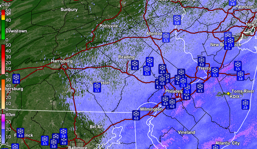
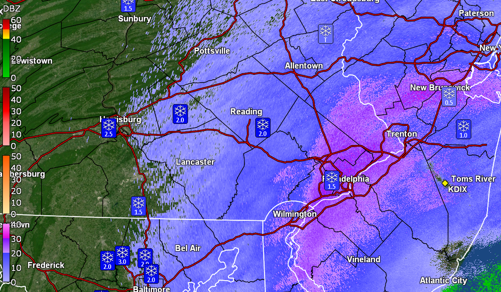
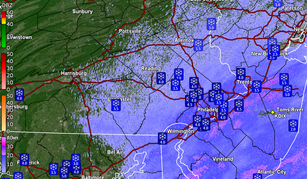
&&PHL reported 4.6" (ASOS). Looks like far South Jersey and Northern Delaware got under the heavier bands.
I may go do one more reading as I noticed some cars that had been cleared after people had returned home from work last night, looked to have been dusted again when I checked this morning.
-
1
-
-
Did a ~5 pm measurement and that back-build after I did the 3 pm one, did net me another 1/4", so for today (at this point), I am up to 4.25".
Am down to snizzle now with temp 27 and dp 25.
Mt. Holly's 3:40 AFD for the city mentioned possible stuff rotating around through the rest of the evening so who knows? Some who are north of the current heaviest bands might cash in on some bonus flakes.
-
1
-
-
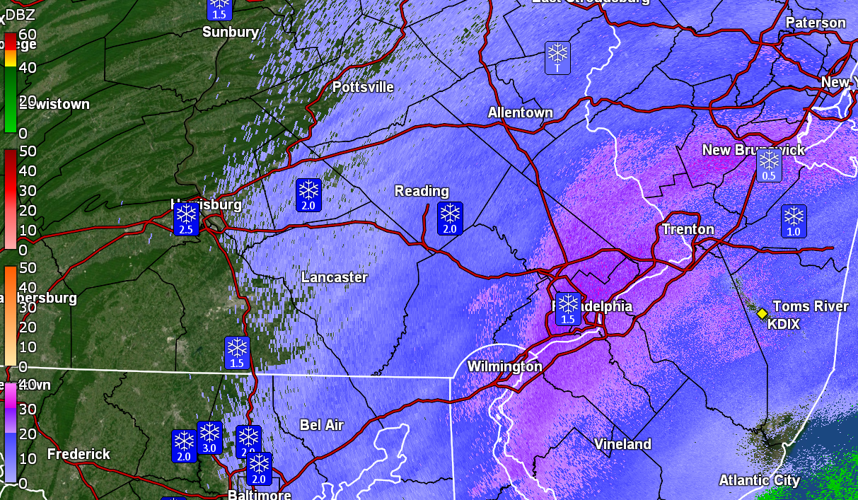
Down to SN-- which is a bit more than flurries or snizzle but is probably looking sparse due to the fine pixie dust flakes. Not sure how much that would have contributed to my 4" since the last check, but it looks like the swath of precip on radar is pulling away to the SE. Will probably do one more measurement before it gets too dark (sun is setting just after 5 pm now).
Currently 27 with dp 26 and a little bit of fog off in the distance.
-
1
-
-
Am getting a bit of a back-build band that upped the intensity a bit intermittently.
-
My 3 pm measurement was 4" on the nose. So far the winds have been non-existent, so I haven't seen any snow blowing around.
Am down to SN- with fine flakes, a temp of 28 and dp 26.
-
1
-
-
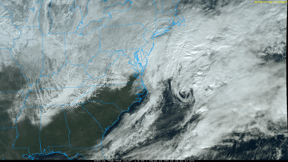
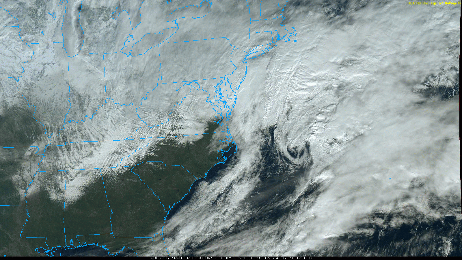
You can see that one low rolling OTS!
-
5
-
-
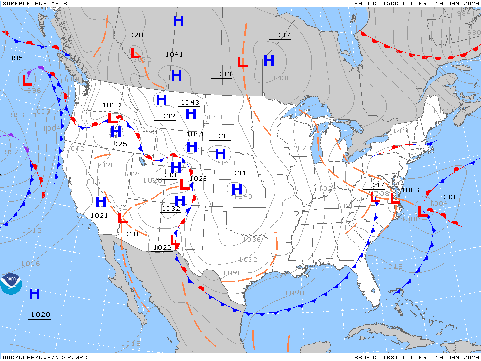
Last HPC surface map (from about an hour ago I believe) -
-
1
-
-
12:15 pm measurement was 3.25" and the flakes are back to the smaller/finer type and still going at a steady SN rate.
Temp is now 28 with dp 26.
-
Must be some kind of warm layer up in the atmosphere as I'm starting to get some pancakes mixed in with regular flakes (the fine stuff has been reduced to a min, although the pancakes will help increase the snow pack faster).
Temp is still 27 with dp now 26 with some fog.
ETA - running an animation of the radar suggests a band is back-building over I-95 so what might have appeared to be a "back edge" hasn't moved that much.
-
1
-
-
Just measured and have 1.75" on the board with moderate snow. Getting bigger flakes mixing in now and am under a stronger blob.
Temp is 27 with dp 25.
-
1
-
-
I am at my low for the day so far (26) where I had a high of 30 (so far) just after midnight.
Currently light snow and 26 with dp 24.
-
Now have SN with fine powdery flakes quietly building up a bed of frozen precipitation. Eyeballing about 1/2" so far IMBY, with temp at 26 and dp 24. My station anemometer and vane are frozen over (the station is about 7.5ft above the ground so would probably need a ladder to carefully knock off the chunk of frozen slushy snow sitting on top of it, without breaking the wind instruments).
-
It's showtime! At some point before 6:30 am here, I looked out and a burst of snow apparently came through and added a dusting to cold/untreated surfaces. Currently SN- and 26 with dp 23.
-
Just now, Kevin Reilly said:
or not LOL. I would expect a lot of wiggling around by this band either side of the Mason Dixon Line 15-25 miles north and 15-25 miles south of it either way. I am telling of the Heaviest Axis of snow should there be one.
Yeah but the HRRR updates every hour so with each run, you have a new chance at winning!
-
 1
1
-
-
Currently bopping between 29 & 30 with dp 20. I did finally clear my board this afternoon, so we wait. If the winds appear as progged, it might be tricky to get a good measurement assuming snow ratios will allow it to blow around more.
-
2 minutes ago, Kevin Reilly said:
Yep a tick SSW LOL
Gonna have to rely on the short-range models now though. The HRRR will become a friend.
-
1
-
-
8 minutes ago, JSharp said:
I remember a Norlun trough in February of 2009 which setup over Philadelphia and Gloucester/Camden Counties. This sucker dropped up to 10 inches in the City of Philadelphia and up to a foot in Gloucester county. South of West Chester, where I live, only saw 4 inches. I think parts of Lancaster County (Manheim Twp.) got 12 inches in another very narrow band (10 miles wide).
There was something more recent although the band set up just to the north of Philly and Philly (at least IMBY) ended up in a dry slot for an extended period of time hoping for some kind of pivot and/or back-building (that did eventually come). Forgot what year but I am sure the thread is still here!
-
1 hour ago, Kevin Reilly said:
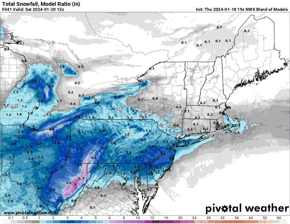
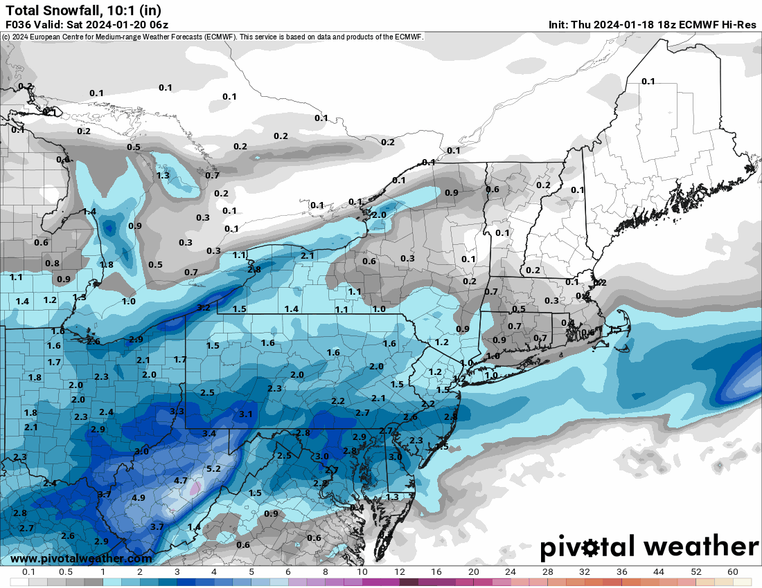
Anyone have a snow map of the 18z Euro? Looks like it ticked south again with the main INVT trough.

-
I actually made it above freezing today, with a high of 33 (when the sun briefly attempted to show through the clouds), a low of 19, and a dp as low as 5 earlier this morning. I meant to tell RedSky that I "saw him" in the east around sunrise before it clouded over, so I knew something was on its way.

It's currently overcast and 30 with dp 19.
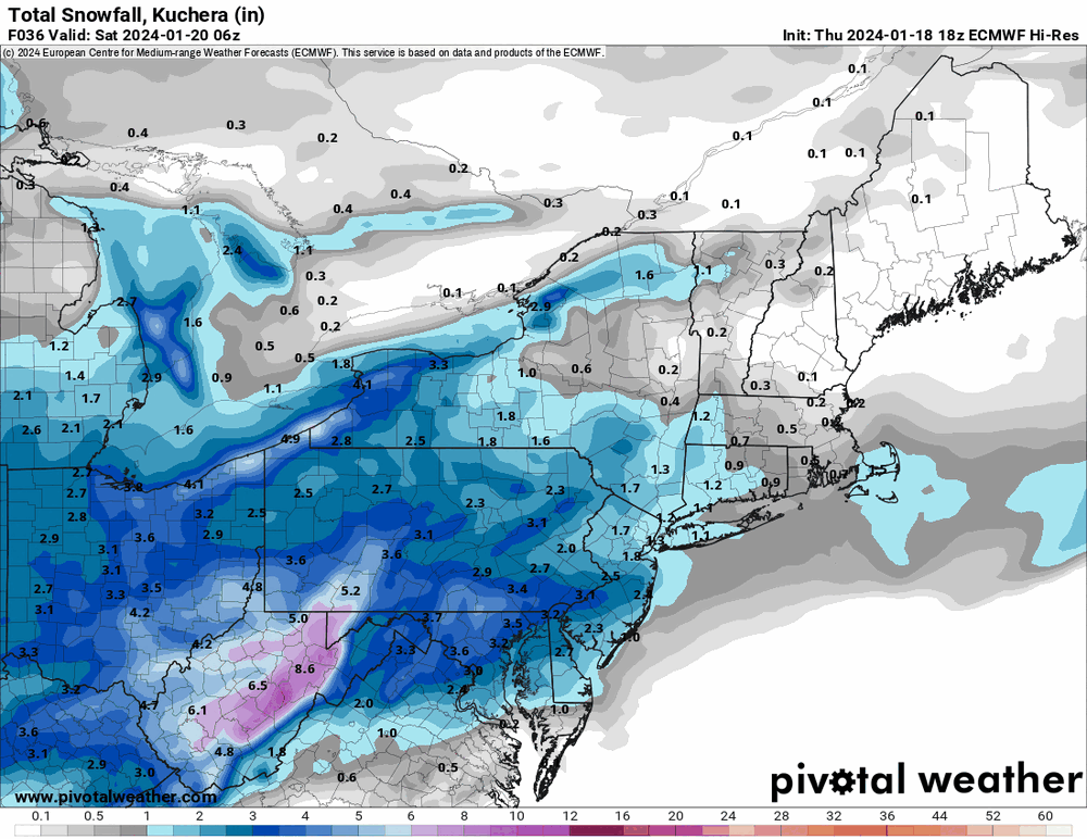
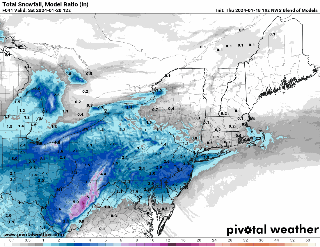
The 19z NBM seems to have the max accumulation right along the I-95 corridor. I suppose a concern might be if a dry slot appears, which I recall happening with past Norlun setups (with one area under a death band and others with zippo).
-
1
-

E PA/NJ/DE Winter 2023-2024 OBS/Discussion
in Philadelphia Region
Posted
Looks like the suggestion was that a Canadian High was going to ooze down over NE and chill things as the Low passes off the coast.
Nailing that this far out (for GFS) might be dodgy though.