

Hurricane Agnes
-
Posts
8,594 -
Joined
Content Type
Profiles
Blogs
Forums
American Weather
Media Demo
Store
Gallery
Posts posted by Hurricane Agnes
-
-
2 minutes ago, anthonyweather said:
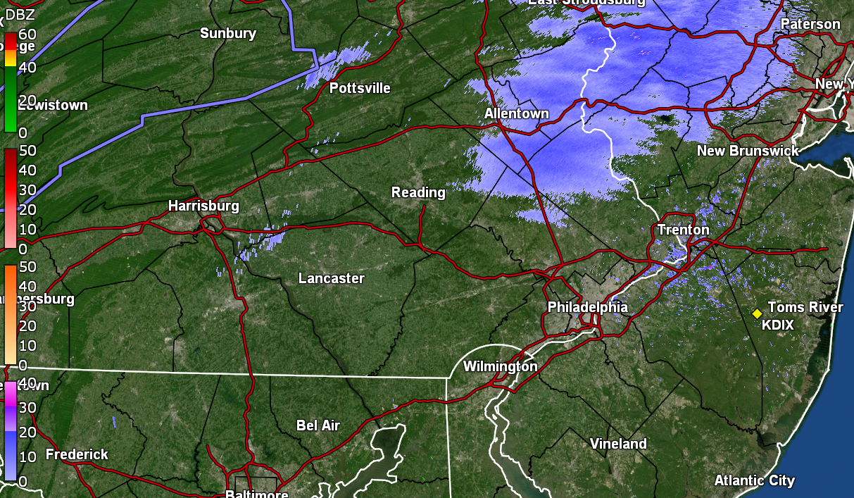
Honestly, I don’t even think it’s reaching the ground aside from a few flurries. I just combed through the traffic cameras in that area.
.It's torching (in a relative sense) where I am with temp now 42 (am guessing as downsloping ahead of a front).
-
Am thinking RedSky is under this and is either outside naked dancing around it or is napping.

-
Junk and stuff incoming for some!
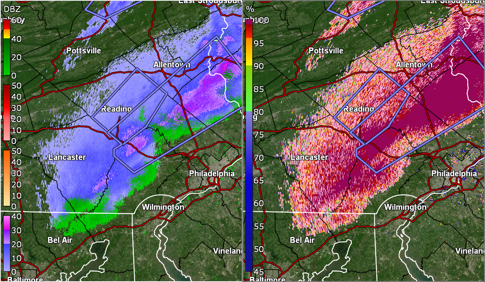
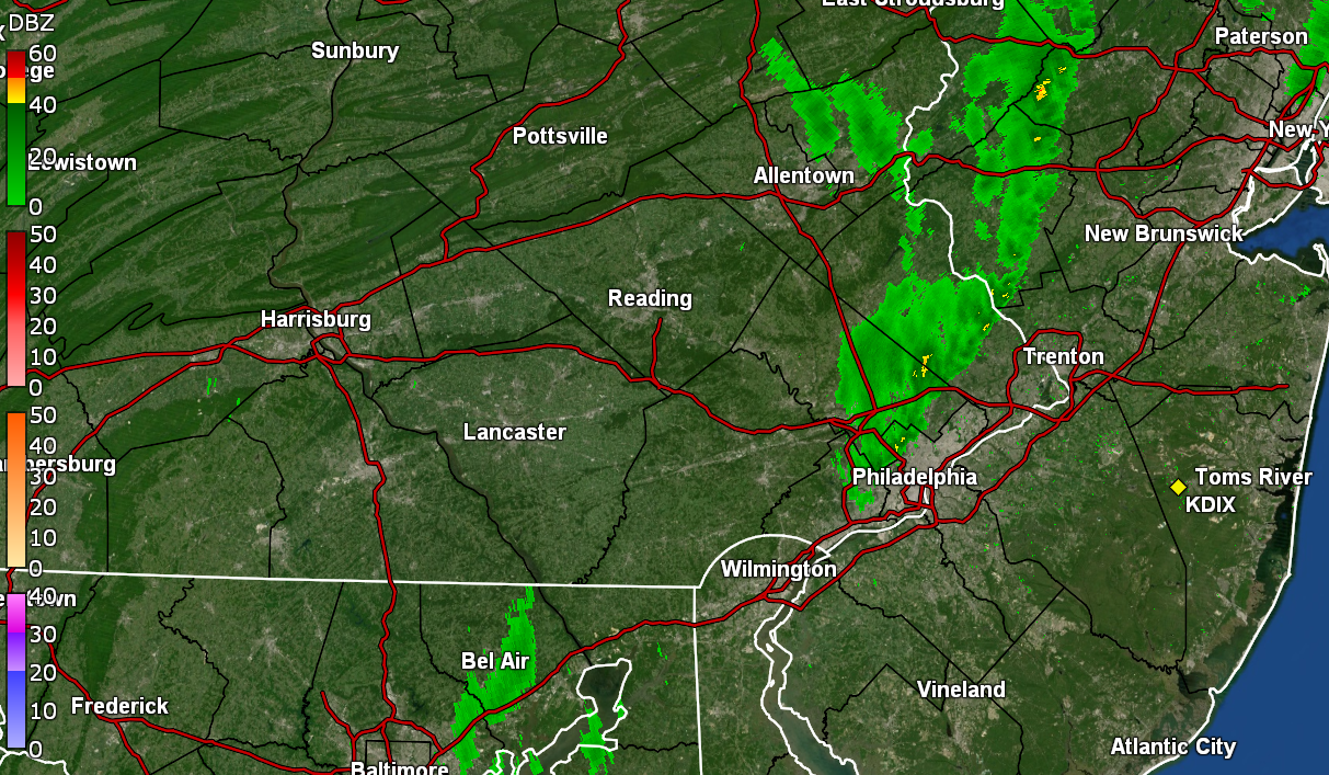
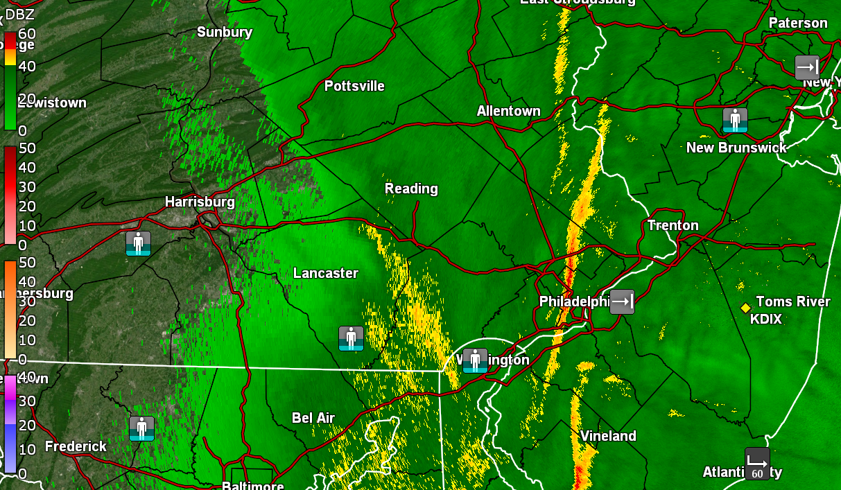
QuoteSnow Squall Warning
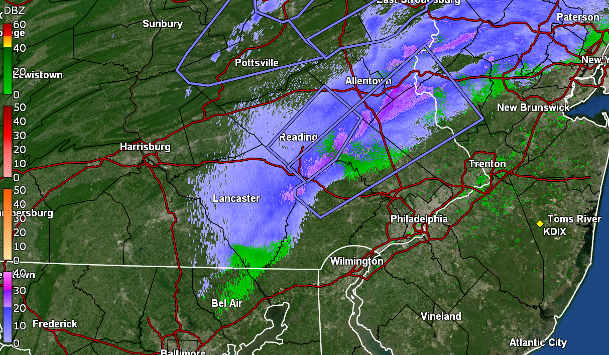
SNOW SQUALL WARNING NWS MOUNT HOLLY NJ 1110 AM EST SUN JAN 14 2024 NJC019-041-PAC011-017-029-077-091-095-141645- /O.CON.KPHI.SQ.W.0003.000000T0000Z-240114T1645Z/ 1110 AM EST SUN JAN 14 2024 Hunterdon County NJ-Warren County NJ-Berks County PA-Bucks County PA-Chester County PA-Lehigh County PA-Montgomery County PA-Northampton County PA- ...A SNOW SQUALL WARNING REMAINS IN EFFECT UNTIL 1145 AM EST FOR CENTRAL HUNTERDON...SOUTHWESTERN WARREN...SOUTHEASTERN BERKS... SOUTHEASTERN LEHIGH...NORTHWESTERN MONTGOMERY...NORTHWESTERN BUCKS... NORTHEASTERN CHESTER AND SOUTHEASTERN NORTHAMPTON COUNTIES... At 1110 AM EST, a dangerous snow squall was located along a line extending from Milford to Elverson, moving east at 70 mph. HAZARD...Intense bursts of heavy snow. Gusty winds leading to blowing snow and rapidly falling visibility. Wind gusts greater than 35 mph. SOURCE...Radar and webcams. IMPACT...Dangerous and life-threatening travel conditions are expected to develop rapidly in the warning area. This includes the following highways... Pennsylvania Turnpike between mile markers 296 and 317. Northeast Extension between mile markers 26 and 52. Interstate 78 in Pennsylvania between mile markers 59 and 76. Interstate 78 in New Jersey between mile markers 0 and 13. Interstate 176 in Pennsylvania between mile markers 1 and 8. Locations impacted include... Allentown, Easton, Bethlehem, Pottstown, Phoenixville, Lansdale, Forks, East Norriton, Coatesville, Emmaus, Quakertown, Perkasie, Doylestown, Byram, Wilson, Downingtown, Souderton, Bedminster, Hellertown, and Birdsboro. PRECAUTIONARY/PREPAREDNESS ACTIONS... Consider avoiding or delaying travel until the snow squall passes your location. If you must travel, use extra caution and allow extra time. Rapid changes in visibility and slick road conditions may lead to accidents. Serious injuries and deaths may result from people exiting their vehicles during a snow squall. Drivers may not be able to see you or stop! If you have been involved in an accident or pulled to the side of the roadway, quickly exit your vehicle and move as far away from the roadway as possible ONLY when it is safe to do so. Do not stand along or near the roadway, since approaching vehicles may be unable to maintain control. LAT...LON 4080 7514 4045 7477 3997 7578 4007 7594 4011 7594 4014 7588 4021 7599 4080 7514 SNOW SQUALL...OBSERVED SNOW SQUALL IMPACT...SIGNIFICANT $$QuoteSnow Squall Warning
SNOW SQUALL WARNING
NWS MOUNT HOLLY NJ
1100 AM EST SUN JAN 14 2024

PAC025-089-141630-
/O.CON.KPHI.SQ.W.0001.000000T0000Z-240114T1630Z/
1100 AM EST SUN JAN 14 2024
Carbon County-Monroe County-

...A SNOW SQUALL WARNING REMAINS IN EFFECT UNTIL 1130 AM EST FOR
SOUTHEASTERN CARBON AND CENTRAL MONROE COUNTIES...

At 1059 AM EST, a dangerous snow squall was located along a line
extending from Monticello to near White Haven, moving northeast at 75
mph.

HAZARD...Intense bursts of heavy snow. Gusty winds leading to
blowing snow and rapidly falling visibility. Wind gusts
greater than 35 mph.

SOURCE...Radar and webcams.

IMPACT...Dangerous and life-threatening travel conditions are
expected to develop rapidly in the warning area.

This includes the following highways...
Northeast Extension between mile markers 72 and 82.
Interstate 80 in Pennsylvania between mile markers 301 and 314.
Interstate 80 in New Jersey near mile marker 0.

Locations impacted include...
Lehighton, East Stroudsburg, Palmerton, Jim Thorpe, Stormville,
Henryville, Brodheadsville, New Mahoning, Kunkletown, Werry Lake,
Gilbert, Delaware Water Gap, Tannersville, Alpine Mountain, Rossland,
Kresgeville, Sun Valley, Jonas, Reeders, and Beltzville State Park.

PRECAUTIONARY/PREPAREDNESS ACTIONS...

Consider avoiding or delaying travel until the snow squall passes
your location. If you must travel, use extra caution and allow extra
time. Rapid changes in visibility and slick road conditions may lead
to accidents.

Serious injuries and deaths may result from people exiting their
vehicles during a snow squall. Drivers may not be able to see you or
stop! If you have been involved in an accident or pulled to the side
of the roadway, quickly exit your vehicle and move as far away from
the roadway as possible ONLY when it is safe to do so. Do not stand
along or near the roadway, since approaching vehicles may be unable
to maintain control.

LAT...LON 4115 7515 4114 7509 4108 7503 4109 7496
          4099 7513 4097 7513 4093 7522 4085 7532
          4082 7540 4078 7567 4073 7576 4082 7588
          4099 7550 4115 7515

SNOW SQUALL...OBSERVED
SNOW SQUALL IMPACT...SIGNIFICANT

$$
ETA to note that temp here in NW Philly IMBY is 41 with dp 28 so not sure what would happen if that hung together and moved this way.
-
 1
1
-
-
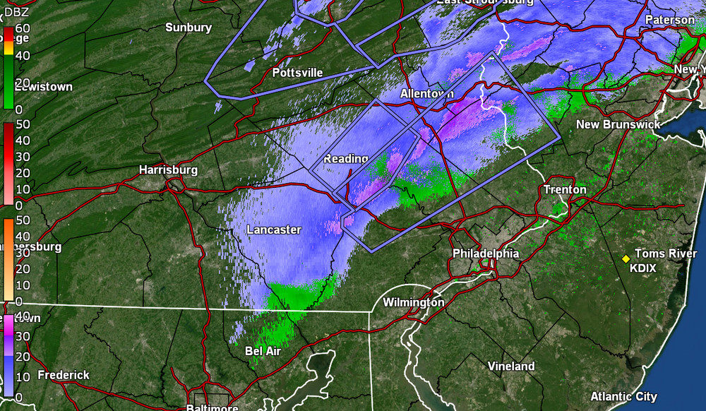
State College has a Snow Squall Warning up for the area E of town/airport -
QuoteSnow Squall Warning
SNOW SQUALL WARNING
NWS STATE COLLEGE PA
929 AM EST SUN JAN 14 2024

PAC027-035-061-067-087-093-097-109-119-141500-
/O.NEW.KCTP.SQ.W.0012.240114T1429Z-240114T1500Z/
929 AM EST SUN JAN 14 2024
Centre County-Clinton County-Huntingdon County-Juniata County-Mifflin
County-Montour County-Northumberland County-Snyder County-Union
County-

The National Weather Service in State College PA has issued a

* Snow Squall Warning for...
Southeastern Centre County in central Pennsylvania...
Southeastern Clinton County in north central Pennsylvania...
Central Huntingdon County in central Pennsylvania...
Juniata County in central Pennsylvania...
Mifflin County in central Pennsylvania...
Montour County in central Pennsylvania...
Northumberland County in central Pennsylvania...
Snyder County in central Pennsylvania...
Union County in central Pennsylvania...

* Until 1000 AM EST.

* At 929 AM EST, a dangerous snow squall was located along a line
extending from Spruce Run Reservoir to Weikert to near Dudley,
moving east at 35 mph.

HAZARD...Intense bursts of heavy snow. Gusty winds leading to
blowing snow and visibility rapidly falling to less than
one-quarter mile. Wind gusts up to 35 mph.

SOURCE...Radar indicated.

IMPACT...Travel will become difficult and potentially dangerous
within minutes.

For those driving on Interstate 80, this includes areas between the
Loganton and Buckhorn exits, specifically from mile markers 191 to
228.

This includes Interstate 180 from mile markers 1 to 7.

This includes the following highways...
Routes 11 and 15 from THE JUNIATA SNYDER COUNTY LINE to NEAR
SHAMOKIN DAM.
Route 11 from near Shamokin Dam to east of Danville.
Route 15 from near Shamokin Dam to near Montgomery.
Route 22 from Huntingdon to Mount Union.
Routes 22 and 522 from Mount Union to Lewistown.
Routes 22 and 322 from Lewistown to east of Thompsontown.
Route 322 from Potters Mills to Lewistown.
Route 522 from Lewistown to Selinsgrove.
Route 522 from Orbisonia to Mount Union.
State Road 45 from Millheim to Lewisburg.
State Road 61 from Sunbury to Mount Carmel.
State Highway 147 from I-80 to Sunbury.

Locations impacted include...
Sunbury, Lewistown, Shamokin, Huntingdon, Milton, Mount Carmel,
Lewisburg, Selinsgrove, Danville, Northumberland, Mifflinburg, and
Kulpmont.

PRECAUTIONARY/PREPAREDNESS ACTIONS...

Slow Down! Rapid changes in visibility and road conditions are
expected with this dangerous snow squall. Be alert for sudden
whiteout conditions.

Reduce speed and turn on headlights! During snow squalls, the
visibility may suddenly drop to near zero in whiteout conditions.

LAT...LON 4077 7639 4066 7671 4059 7717 4056 7717
          4041 7753 4038 7753 4026 7771 4021 7819
          4023 7824 4029 7826 4035 7822 4095 7743
          4108 7718 4109 7698 4115 7696 4115 7664
          4106 7661 4096 7652 4083 7650 4083 7641
          4077 7639

SNOW SQUALL...RADAR INDICATED

$$
Currently have changeable skies (sun has popped out recently) and 36 with dp 26.
-
2 hours ago, yak said:
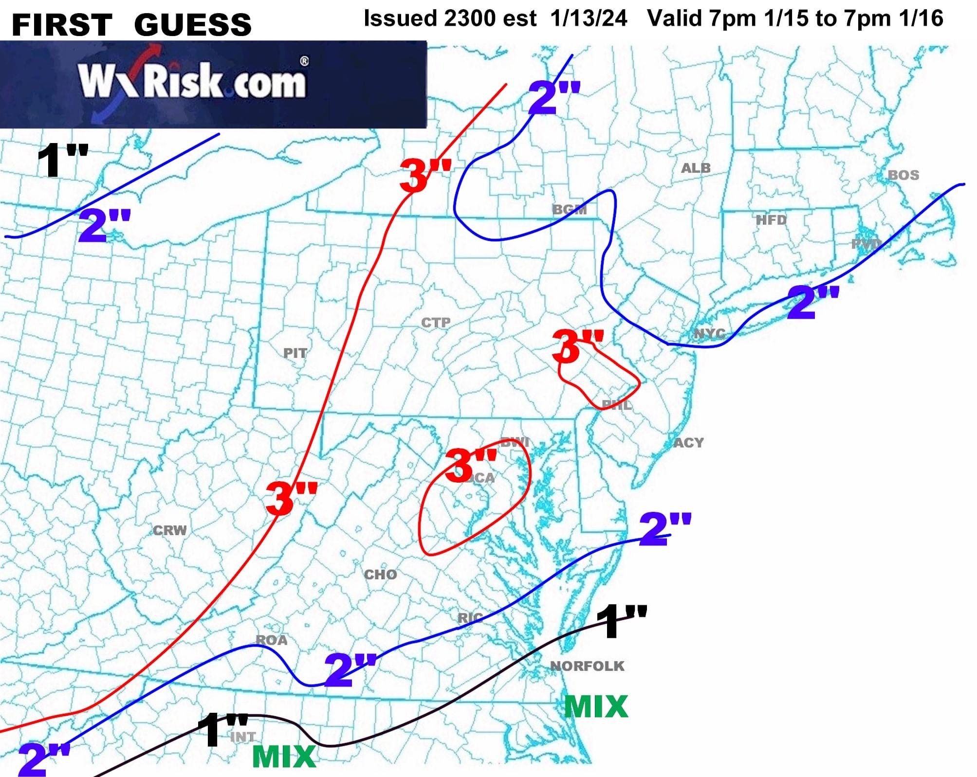
DT's First Guess Map. 3 inches area wide with inexplicable 3" lollipops in the DC and Philly metro areas.

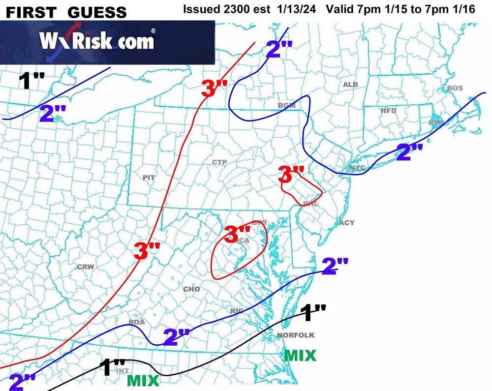
ETA - The map is weird but I think that it is 2" area-wide with the 3" lollipops.
There are parts of NW DC Metro, e.g., Montgomery County, MD, and NW Philly (like where I am), as well as Montgomery County, PA, that have rolling hills with elevations of 300 ft - 400 ft.
Ever since I was a kid (and even today), I was always fascinated on car trips to Willow Grove traveling north along Easton Rd. - especially going down the hill from Edge Hill Rd to Susquehanna Rd where the Roslyn train station is (which has an at-grade RR crossing, one of the few in the area).
Similarly, I had many work trips down to D.C. metro and specifically the Rockville/Bethesda/Gaithersburg area, where the hills abound (as well as the propensity for severe storms, not unlike Willow Grove).
So far I may have bottomed out at 29 this morning (but will see what happens in the next hour or so) and am currently at 30 with dp 23. Will be on the lookout for flizzards and whatnot.
-
7 hours ago, Birds~69 said:
Not at all. They are a mess. I'm trying to convince myself but they are too far gone and not on the same page.
Betting? 6 point tease is where I'd go.
TB +9
Pitt +15.5

I just saw where the Bills/Steelers game was moved to Monday at 4:30 pm due to an incoming blizzard.
(*ducks as Birds yells WIMPS!!!!!! and hurls stuff*
)
-
 1
1
-
-
6 minutes ago, ChescoWx said:
Tomorrow's potential sweeper event for the more northern folks in the forum....buckle up!!

Well it did keep some shovelable for Tues/Wed.
-
Just when I though things were done earlier this morning when the sun came out, it clouded over again and I got an additional 0.06" of rain from a band that came through the past couple hours. That brings the total to 0.59" for the day (0.96" 2-day total).
My high ended up being 58 just after 6 this morning and it's down to 48 and clearing, with some sun, and dp 40.
-
1
-
-
Have some leftover light rain moving through but so far picked up 0.37" last night and 0.53" this morning for a 2-day event total of 0.90". My "low" in this non-diurnal temp regime, was 49 at midnight, and so far my "high" has been my current 57, with dp 57.
5 hours ago, Kevin Reilly said:So far this storm is overhyped it is very underwhelming just some light steady rain and the wind is a complete dud maybe I had a gust to like 25 mph at best so far. This whole dam thing sucks. Something has to give I mean it's below zero out west now.
PHL hasn't gone below 0F in 30 years (since 1994).

-
1
-
-
2 minutes ago, RedSky said:
Couple of wasps spotted today in the NYC thread. Winter's coming ya little bastards, yes winter's coming.
My snow drops have been spotted coming up so there's that.
Bottomed out at 29 this morning and made itu p to 49 for a high. There was an active breeze today as well.
Cloud deck has moved in and some junk-n-stuff off to the west. Currently 45 with dp 35.
-
Due to the non-diurnal temps post-storm, my "high" happened at 12:30 am and my "low" is my current temp of 45 (so far), with dp 32. It was good to see the sun dry things out a bit but the ground is saturated and thanks to the winds today, there were lots of branches around, although not as bad as it probably could have been. Was glad the power held! Looks like Chester County had the biggest impact for power outages.
-
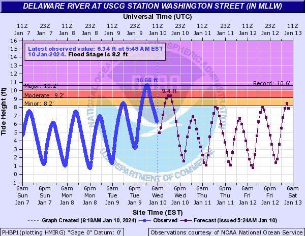
Heard this morning the Delaware hit a record peak at 10.66 ft for the day (at Washington Ave in South Philly). I know one small section further north on Columbus Blvd near the Ben Franklin Bridge is like 5 ft below sea level, so that will periodically have some very minor flooding with the tides.
-
1
-
-
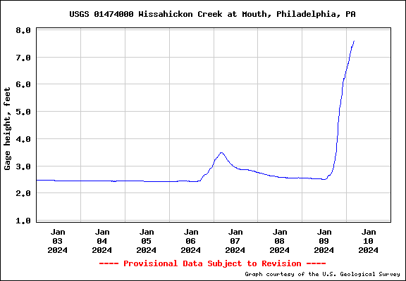
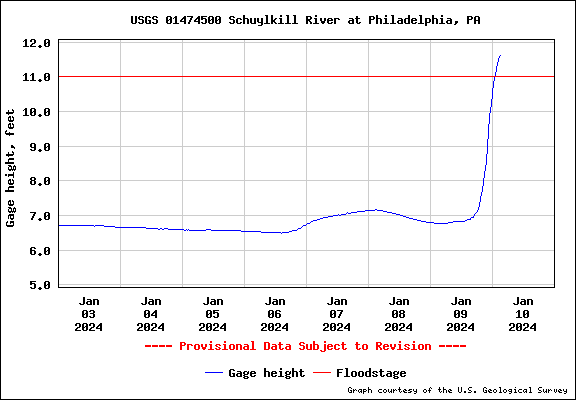
Finished up with 3.39" of rain from the event and a small line came through here the past hour but didn't produce anything measurable here.
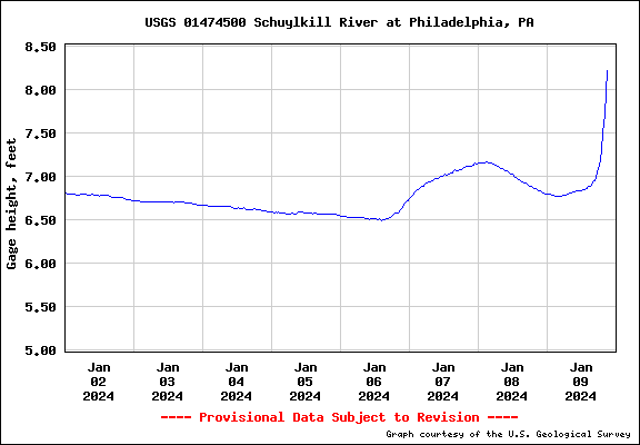
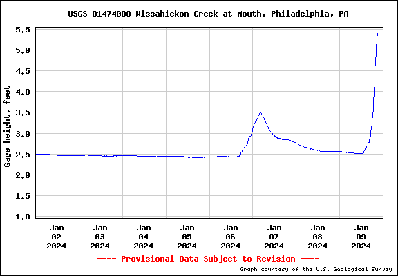
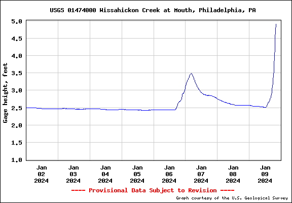
Currently 52 with dp 48. Wissahickon still rising (7.34 ft) and Schuylkill at PHI is flooding (11.62 ft) and still going.
-
1
-
-
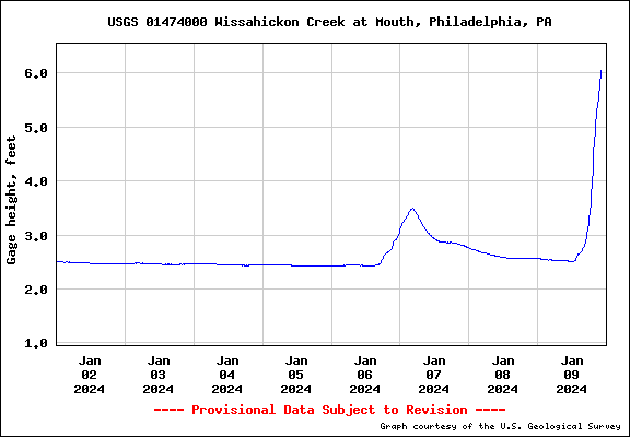
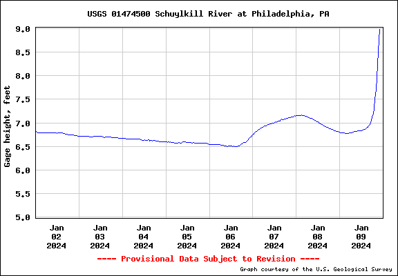
Temp down to 55 with dp 55. Some moderate rain bands coming through and have 3.23" recorded so far. Wissahickon is at 6.05 ft as pf 10 pm so way way out of its banks. Schuylkill @ PHL is at 8.99 ft so quickly getting there.
-
Temperature drop is real and now down to 56 with dp 56. My high hit 58 at 9:30 pm tonight. Rain rate has dropped considerably and currently have 3.08" in the bucket. Back edge looks to be in Lancaster County.
-
1
-
-
40 minutes ago, Maxwell03 said:
Yikes
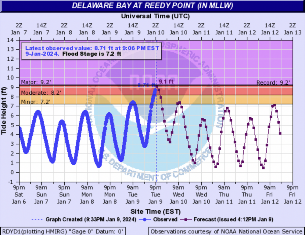
New Moon is Thursday so the tides are normally running a bit higher (luckily it's not the Full Moon I guess).
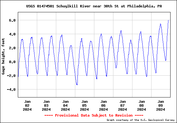
Schuylkill @30th St. is responding and at 6ft (as of 9pm).
-
Schuylkill at PHI rising but still has some room (but with what has to come, will probably hit some kind of flood stage).
-
1
-
-
Now at 3.01", temp 57 but creeping down, dp 56. Wissahickon definitely out of its banks (9pm @ 5.4ft) and probably flooding Lincoln Drive.
-
1
-
-
Got up to 1.91"/hr rate and have 2.95" in the bucket.
-
1
-
-
1 minute ago, dankil13 said:
Winds are so strong out of the south at PHL is using runway 17 for all arrivals and departures vs the 27/9 R/L. A few of the 789s to Europe appear to be sitting on the sidelines hoping for the crosswinds to die down enough to take off on 27/9
Yeah they are going to have to wait that out.
-
1
-
-
Now under the beginning of the rope. Rain is LOUD along with the wind. over 1"/hr rates.

-
1
-
-
8 minutes ago, RedSky said:
What it really looks like is the Nexus ribbon on Star Trek
We'll soon end up in Idaho with Kirk chopping wood!
Temp now up to 58, dp 57, 2.62" in the bucket and rope on my doorstop just a few miles to the west.
-
3
-
-
17 minutes ago, KamuSnow said:
The rope appears to be dissipating, maybe because a new one seems to have formed just to the east. The rain is getting heavier though. Let me show you the ropes:

I'm finally "hearing" the howling winds here (from my front which is rare - I usually hear the winds in the back that faces NE).
Wissahickon Creek (at the mouth to the Schuylkill) pretty much out of its banks now as of 8 pm so probably worse with the 9 pm update).
-
2
-
-
My Upper Darby sis said it's like a tornado where she is - winds howling, patio furniture moving around, things thumping, planes flying low.
-
1
-


E PA/NJ/DE Winter 2023-2024 OBS/Discussion
in Philadelphia Region
Posted
Getting an alert here now (for Montco to my NW). See the dark clouds to north.