

WxSynopsisDavid
-
Posts
511 -
Joined
-
Last visited
Content Type
Profiles
Blogs
Forums
American Weather
Media Demo
Store
Gallery
Posts posted by WxSynopsisDavid
-
-
3 minutes ago, buckeyefan1 said:
Someone please start a banter thread to keep this one on topic
Done, just created it.
-
 1
1
-
-
Banter for Idalia
-
4 minutes ago, TheGhostOfJohnBolaris said:
Again, am I missing something here?
As I mentioned earlier, until we get a solid core and eye with Idalia models will continue to fluctuate with track and intensity.
-
 8
8
-
-
1 minute ago, StantonParkHoya said:
GFS showing a weaker landfall on 18z
Honestly, until Idalia develops a solid core (which will take several more hours), model track and intensity will continue to fluctuate.
-
4
-
-
29 minutes ago, Hotair said:
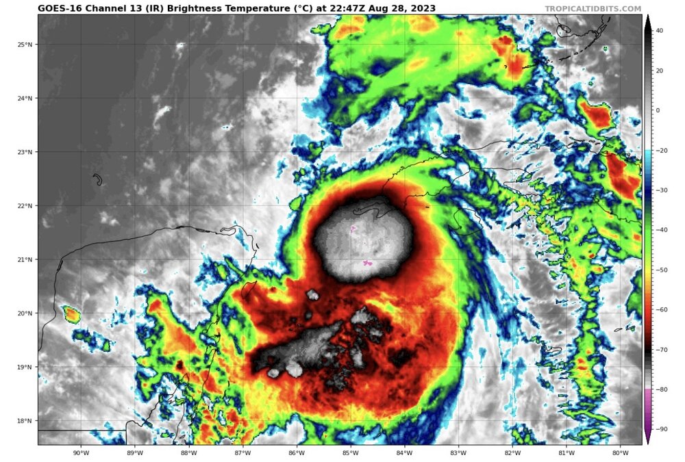
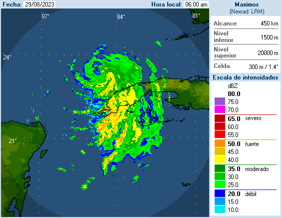
Satellite is suggestive of Idalia forming an eye .
Negative. The cloud tops are casting a shadow that is given the appearance of an eye. No eye is developing yet, according to recon.
-
6
-
-
1 minute ago, SnoSki14 said:
I think there are much more negative factors than with previous storms. A lot of dry air and shear present and it won't ever get fully favorable.
Plus time will be a factor. I don't think warm SSTs alone will do it.
I don't expect more than a Cat 2 at landfall.
Shear has actually rapidly decreased the last 3 hours. Shear values north of Idalia went from 40kts to 25kts now. Dry air has abated the core and there’s little dry air to the north. This is a similar environment that Michael had in all honesty. One could argue a better environment ahead than what Michael had.
-
3
-
-
3 minutes ago, Rtd208 said:
I know everyone is concentrating on Florida but eventually there are going to be some impacts in GA, SC and NC as well.
No one has forgotten but there are still uncertainties on track and intensity. Unfortunately we won’t really know for sure what those impacts will be until Tuesday.
-
1
-
-
4 minutes ago, LakeEffectKing said:
Probably in the next 18-24 hrs. Takes a bit of time to get all levels aligned AND to clear out the center....then boom!
I’ll take that bet and say 12hrs tops. So far what Idalia was able to pull off with 30kts of shear was impressive.
Also….Idalia is now beginning to interact with a noticeable warm eddy so I think because of this the process happens much sooner.
-
1 minute ago, LakeEffectKing said:
Seen this dog and pony show before....too many parameters trending positive for RI in 18-36 hrs.
Idalia should easily be a major by tomorrow, and may very well be CAT 4 by 06z Wed.
Once that vertical column stacks, it’s game on. We are close now to that happening.
-
1
-
-
6 minutes ago, WxWatcher007 said:
Yeah I mean as long as there are deep convective bursts like this it makes it more likely we see it wrap up. The hurricane models have had a good handle on its structure looking at 00z. It may take time, but a legitimate signal remains for a major hurricane.
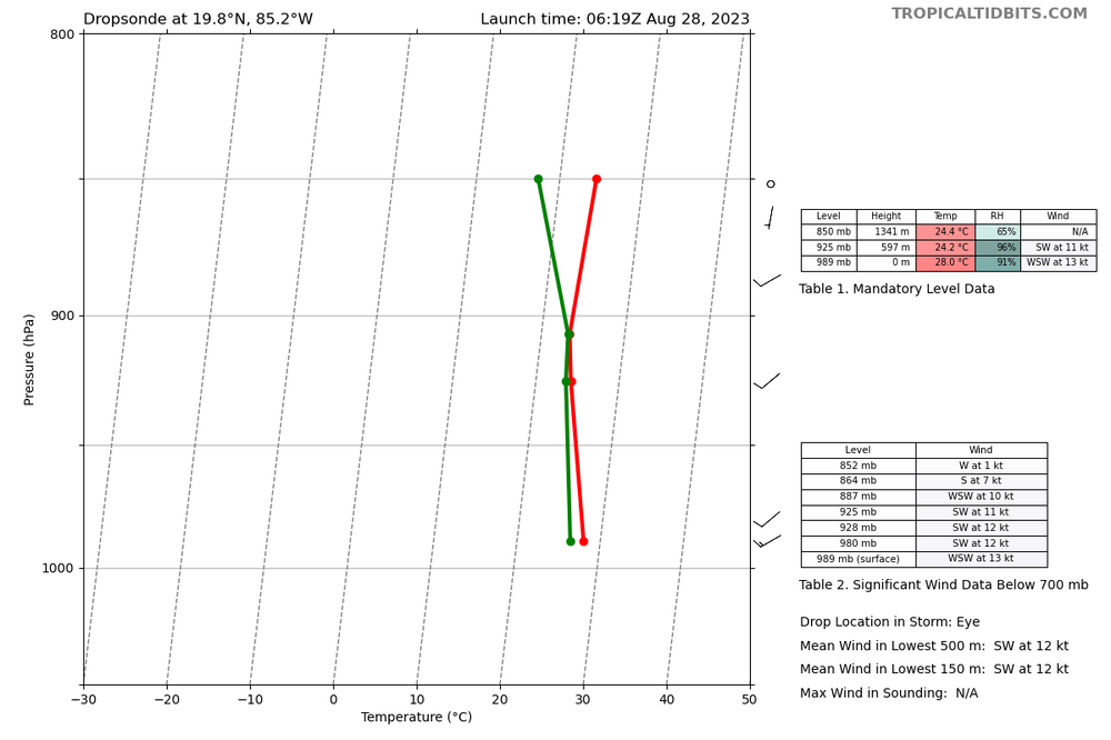
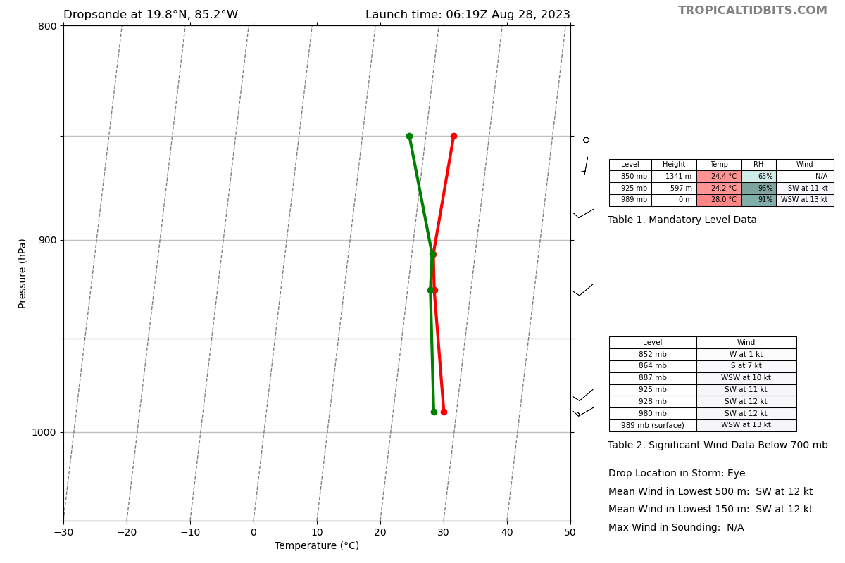
Latest dropsonde suggests that the pressures are lower than the extrapolated, and the first sonde about an hour ago, so it's moving along...
Off to bed now. Night everyone.
Product: Air Force Temp Drop (Dropsonde) Message (UZNT13 KNHC)
Transmitted: 28th day of the month at 6:24Z
Agency: United States Air Force
Aircraft: Lockheed WC-130J Hercules with reg. number AF97-5304
Storm Name: Idalia
Storm Number: 10 (flight in the North Atlantic basin)
Mission Number: 3
Observation Number: 15 ( See all messages of this type for this mission. )
Part A...
Date: Near the closest hour of 6Z on the 28th day of the month
Highest Mandatory Level For Which Wind Was Reported: 925mb
Coordinates: 19.8N 85.2W
Location: 143 statute miles (229 km) to the SE (131°) from Cancún, Quintana Roo, Mexico.
Marsden Square: 045 ( About )
Surface and Standard Isobaric Surfaces Level Geo. Height Air Temp. Dew Point Wind Direction Wind Speed 1000mb -96m (-315 ft) This level does not exist in this area of the storm above the surface level. 989mb (29.21 inHg) Surface (Sea Level) 28.0°C (82.4°F) 26.4°C (80°F) 240° (from the WSW) 13 knots (15 mph) 925mb 597m (1,959 ft) 24.2°C (75.6°F) 23.6°C (74°F) 230° (from the SW) 11 knots (13 mph) 850mb 1,341m (4,400 ft) 24.4°C (75.9°F) About 17°C (63°F) No Wind Report Available For This Level
Information About Radiosonde:
- Launch Time: 6:19Z
- About Sonde: A descending radiosonde tracked automatically by satellite navigation with no solar or infrared correction.
Remarks Section...
Dropsonde Location: Dropped in center.
Highest altitude where wind was reported:
- Location: 19.81N 85.19W
- Time: 6:19:25Z
Lowest altitude where wind was reported:
- Location: 19.82N 85.19W
- Time: 6:21:23Z
Mean Boundary Level Wind (mean wind in the lowest 500 geopotential meters of the sounding):
- Wind Direction: 230° (from the SW)
- Wind Speed: 12 knots (14 mph)
Deep Layer Mean Wind (average wind over the depth of the sounding):
- Wind Direction: 230° (from the SW)
- Wind Speed: 10 knots (12 mph)
- Depth of Sounding: From 852mb to 989mb
Average Wind Over Lowest Available 150 geopotential meters (gpm) of the sounding:
- Lowest 150m: 155 gpm - 5 gpm (509 geo. feet - 16 geo. feet)
- Wind Direction: 230° (from the SW)
- Wind Speed: 12 knots (14 mph)
Sounding Software Version: AEV 30407
Part B: Data for Significant Levels...
Significant Temperature And Relative Humidity Levels Level Air Temperature Dew Point 989mb (Surface) 28.0°C (82.4°F) 26.4°C (80°F) 907mb 23.4°C (74.1°F) 23.2°C (74°F) 850mb 24.4°C (75.9°F) About 17°C (63°F) 843mb Unavailable Significant Wind Levels Level Wind Direction Wind Speed 989mb (Surface) 240° (from the WSW) 13 knots (15 mph) 980mb 230° (from the SW) 12 knots (14 mph) 928mb 225° (from the SW) 12 knots (14 mph) 887mb 240° (from the WSW) 10 knots (12 mph) 864mb 190° (from the S) 7 knots (8 mph) 852mb 280° (from the W) 1 knots (1 mph) Night man, thanks for the analysis and breakdown of recon data.
-
1
-
-
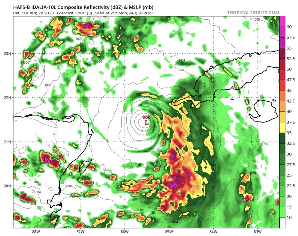
989mb
-
1
-
-
1 minute ago, WxWatcher007 said:
992.2mb extrapolated on the second pass. Peak FL of 53kts and SFMR of 47 & 48kts. Idalia has made a lot of progress in the last 24 hours in tightening up, but it's not there yet in terms of developing a nascent inner core. Not enough upshear thunderstorm activity is limiting intensification. For now.
My suspicion is that there is some sort of internal process happening. Next 3-6hrs will be interesting.
-
1 minute ago, GaWx said:
I'm becoming increasingly concerned even up here for potential major impacts if a worst case scenario of a major hurricane FL landfall and subsequent track too close to this area were to materialize. In that worst case scenario, it would be difficult to deal with due to complicating family circumstances (disability related). Ugh
Someone with more experience can correct me if my assumption is wrong, but if the vertical column stacks within the next 6-8hrs i believe the worse case scenario will unfold. Really hinges on how Idalia organizes/develops the core and if it continues to abate the shear and dry air
-
1 minute ago, schoeppeya said:
Getting salty
Not good, this falls in line with the hurricane models that have been on the higher-end of the intensity forecast.
-
3 minutes ago, WxWatcher007 said:
Just a really cool loop to watch
Right at the end of the loop, you can see that the lightning activity starts to ramp up and circles around the core, noticeable ring like feature. I have only seen that with systems that are beginning an RI process or systems that have an RI underway.
-
-
8 minutes ago, WxWatcher007 said:
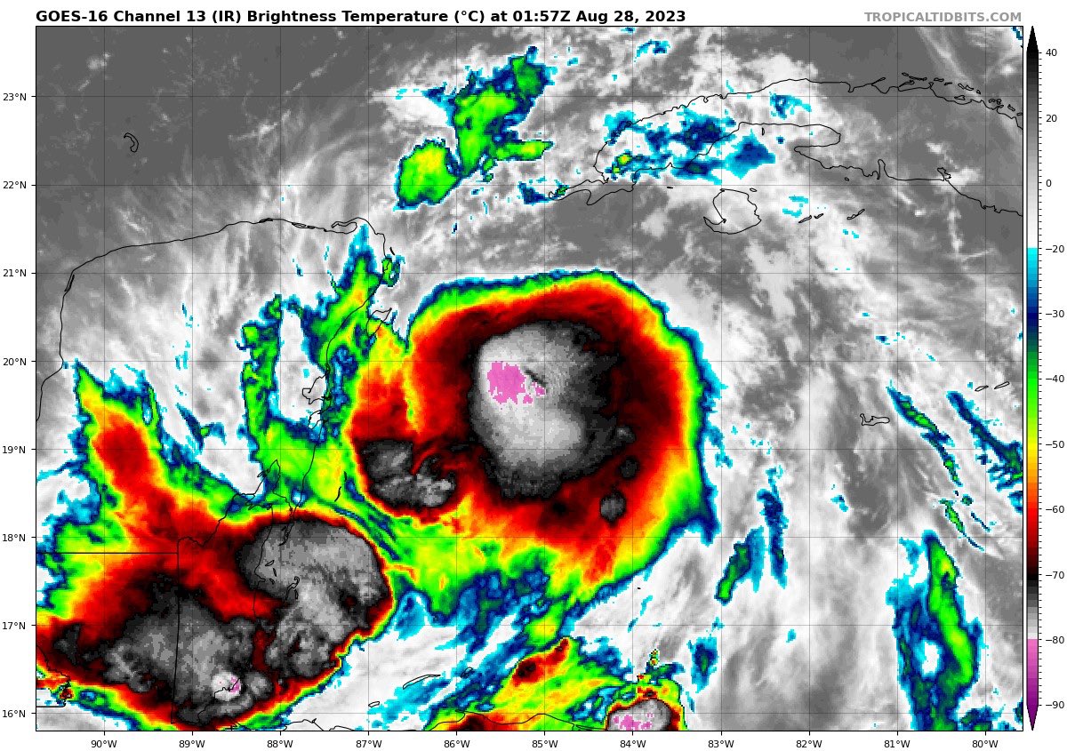
That buoy is displaying a legit pressure fall. Looking at that, IR, and most importantly radar, it looks like Idalia is trying to take this latest mesovortex and turn it into the beginnings of an inner core.

The longer the convective towers can fire absent disruptive shear and dry air intrusion, the more likely it’ll be able to go from mesovortex in a broader circulation to nascent inner core. Seeing convection try to rotate upshear on radar is a meaningful piece of data.
I agree, this is likely the beginning of an established inner core being developed. Very impressive to see this right now.
-
1
-
-
2 minutes ago, Rtd208 said:
Really don't want this thing to take it's time moving ashore in those warm SST's. Not a great trend to have in this juncture. However...only real silver lining with a slower speed is it will increase the likelihood of an internal process such as an Eyewall Replacement Cycle being induced. Current forecast, showing Idalia moving ashore at a faster speed, does not support internal processes happening.
-
2 minutes ago, SnowenOutThere said:
I’m aware but same principle for both. Franklin was just a good recent example.
Disagree, Idalia does not even have an established CDO yet so what's happening tonight is not in relation to CCC. Idalia's issue is shear ATM. Once convection can stay consistent and shear/minimal dry air can abate, this thing takes off. Pretty much...the vertical column is not stacked yet and that is Idalia's hinderance in the short term.
-
-
10 minutes ago, SnowenOutThere said:
For something more on topic I wonder if the recent convective blowup over the core could be an actual indicator of strengthening or just arrested development. Heres a tweet and link to an article on arrested development. IF this isnt arrested development then things could get pretty interesting tonight
https://journals.ametsoc.org/view/journals/mwre/127/1/1520-0493_1999_127_0132_atcwae_2.0.co_2.xml
That link is for TS Franklin, not TS Idalia.
-
1
-
-
4 minutes ago, dan11295 said:
I don't think the circulation is vertically stacked just yet, as impressive as the convective burst is.
When the circulation becomes vertically stacked you have a Category 1. So of course, circulation is not stacked as we don't have a category 1 yet.
-
1 minute ago, WxWatcher007 said:
A little west of runs yesterday. Recon will be taking off around 6am and we’ll have a bunch of data going into the models so hopefully the end up with a high confidence forecast.
At the very least, I am more interested on the data they collect out ahead of the system across the Gulf. Curious to know if the models are right concerning the non-existence of dry air and the observations yielding decreasing shear.
-
1
-
-
15 minutes ago, WxWatcher007 said:
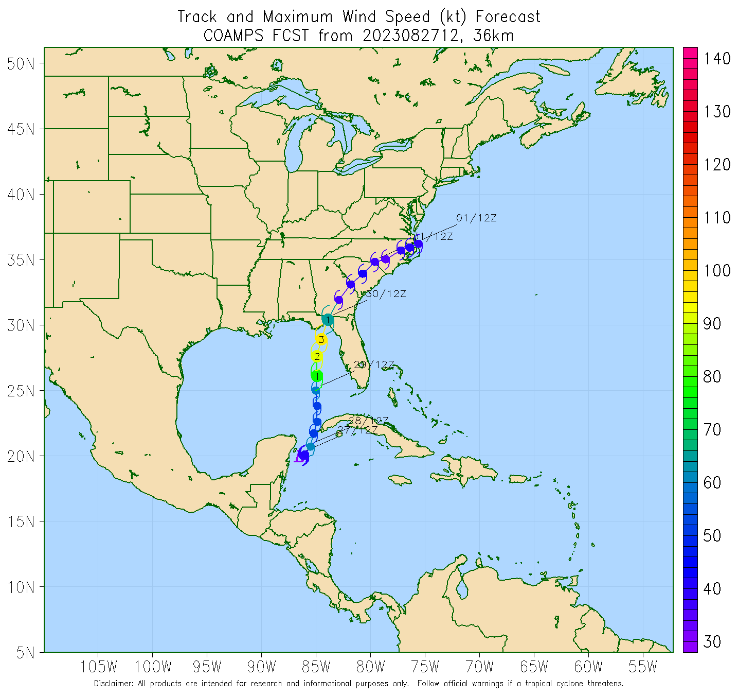
You can see on that graphic that it’s still working under the influence of the ULAC. That’s been key to development given the shear in the region. It’s basically working in a pristine TC genesis environment currently—and land is the only thing that could be reasonably expected to slow this down before it lifts into the Gulf.
Agreed, and it is not good that as forecasters we have no limiting factors in play here to discuss. It's come down to how long it lingers near the Yucatan....really feels like dejavu from some of the previous big gulf storms we have forecasted.
-
1
-


Idalia Banter
in Tropical Headquarters
Posted