

WxSynopsisDavid
-
Posts
430 -
Joined
-
Last visited
Content Type
Profiles
Blogs
Forums
American Weather
Media Demo
Store
Gallery
Posts posted by WxSynopsisDavid
-
-
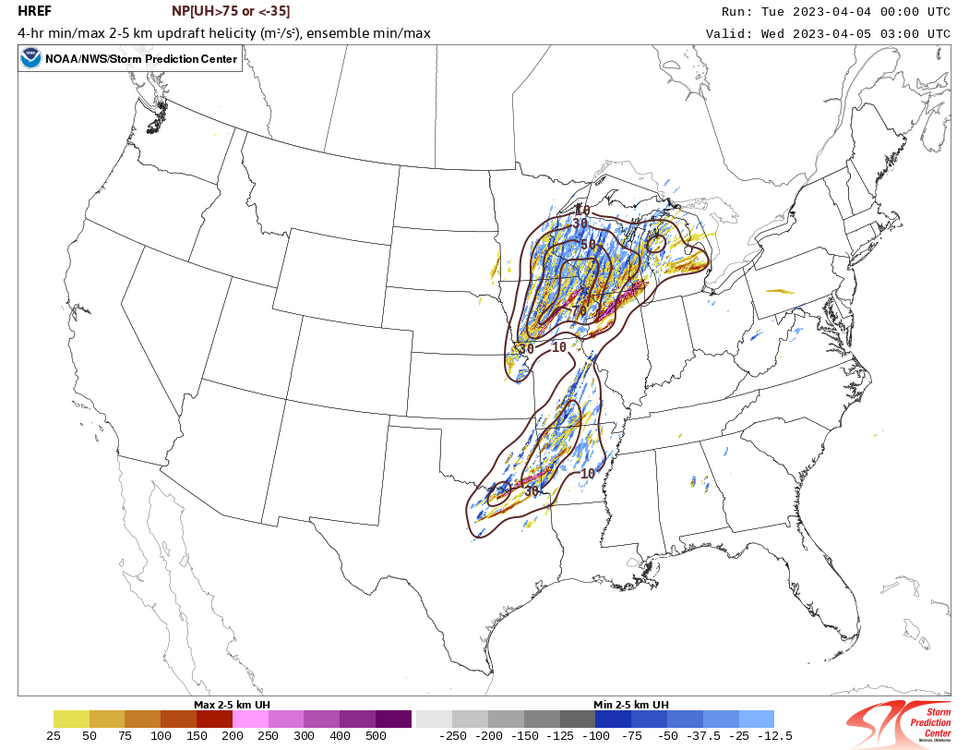
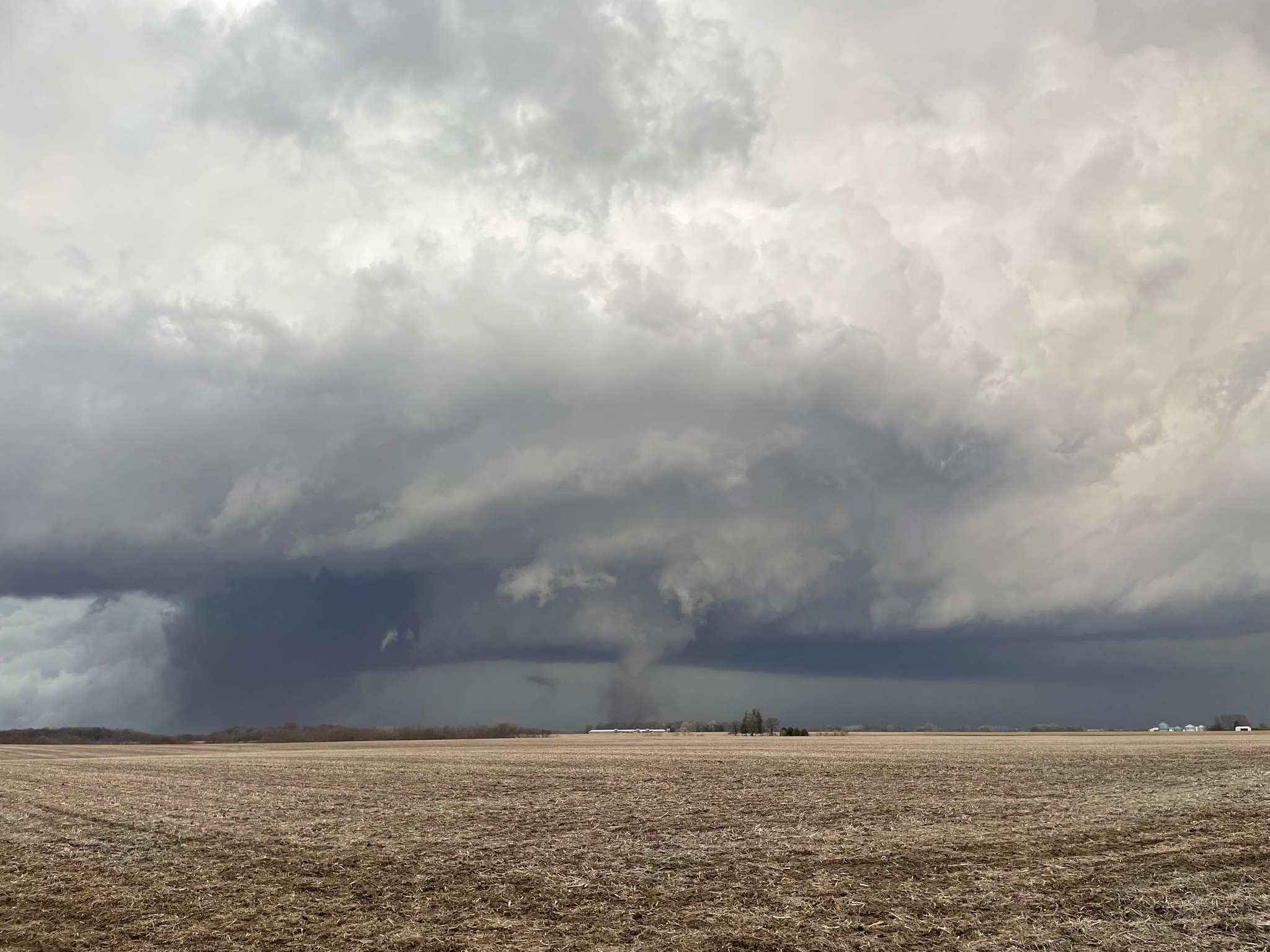
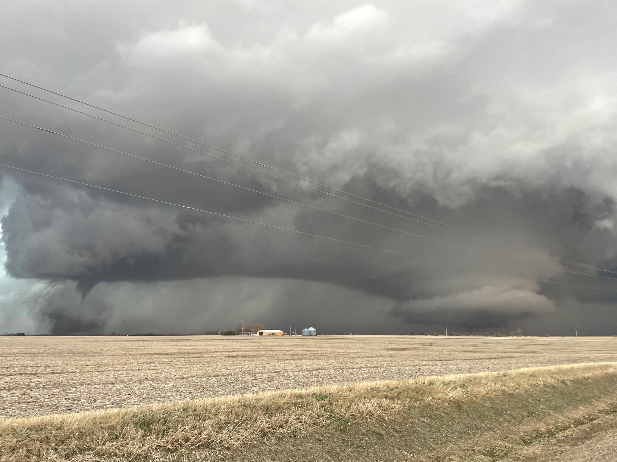
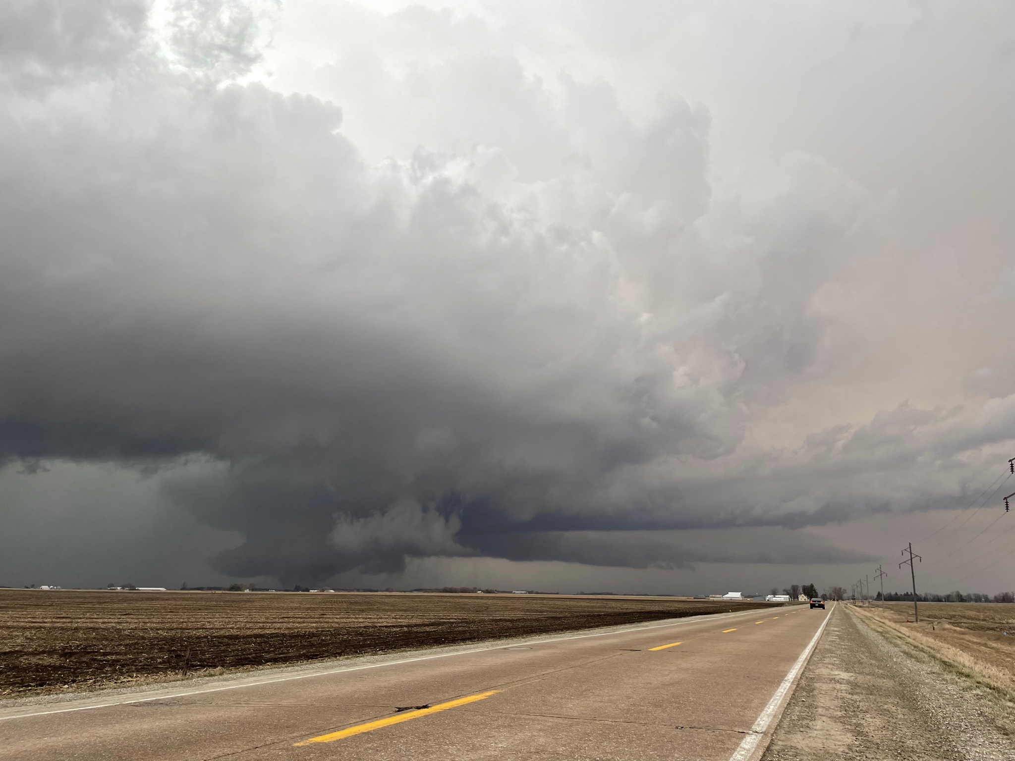
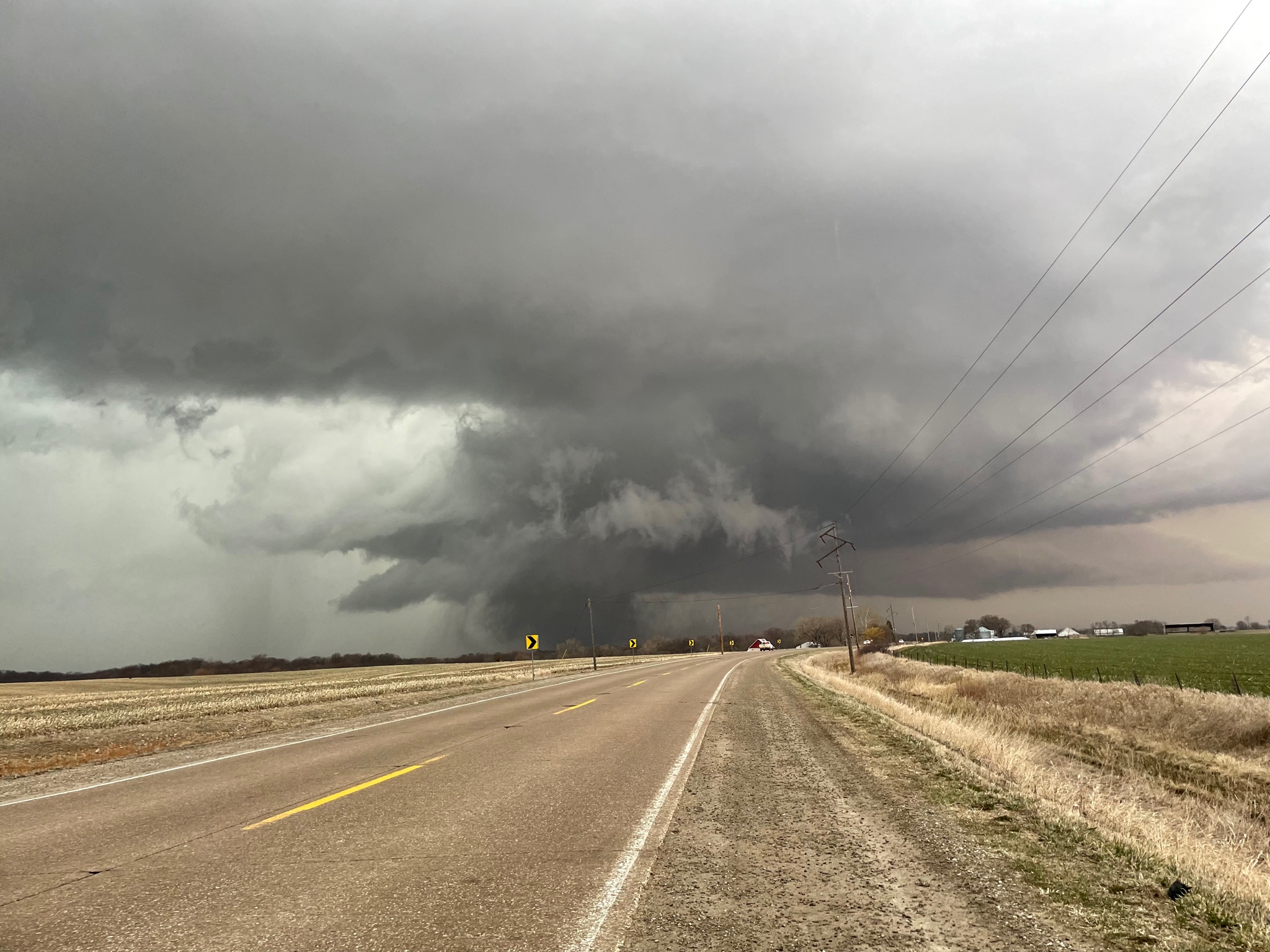
New couplet to the south, just south of banner
-
2 minutes ago, StormChaser4Life said:
I thought the same thing. Might just be the HRRR being special. Just crazy that it's been so consistent then derails now. Definitely something to watch.
The 3k NAM rolling in right now is equally bad. Tries to pop rogue cells in Georgia while keeping everything else linear.
-
 1
1
-
-
Something just appears off with these runs this morning. Mixing issues and capping issues are more prevalent right now. Concerning Wednesday, the HRRR has very little STP and parameters for the OH/TN Valley which seems odd.
-
Wednesday is really starting to look like a Major Severe Weather Outbreak. When the models started to slow the arrival of the front and short wave ejection, it was evident where we were going with this. The activity tomorrow, considering it initiates around or after sunset, will track east and lay down boundaries. Really be interesting to see if a cluster/MCS develops tomorrow night or early morning Wednesday. That tends to always happen the morning of a Major outbreak in the OH/TN Valleys and Great Lakes region.
-
 1
1
-
-
7 minutes ago, Chinook said:
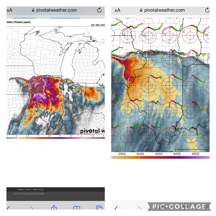
I don't think the CAMs have a lot of storms, if you exclude the FV3 monster storm near Chicago. (seriously, that's like a 10mile wide updraft helicity track. I mean, it could represent a realistic tornado threat that's not a super monster.)
Overall there’s very little discrete. The models that do have daytime convection tomorrow, it’s either linear or a multi-cell cluster. RAP, RRFS-A, HREF initiates discrete after sunset close to midnight. The tornado threat appears to be primarily nocturnal now. Early Wednesday morning into Wednesday afternoon.
-
Latest HRRR and RRFS-A showing morning convection going through the warm sector
-
22 minutes ago, Roger Smith said:
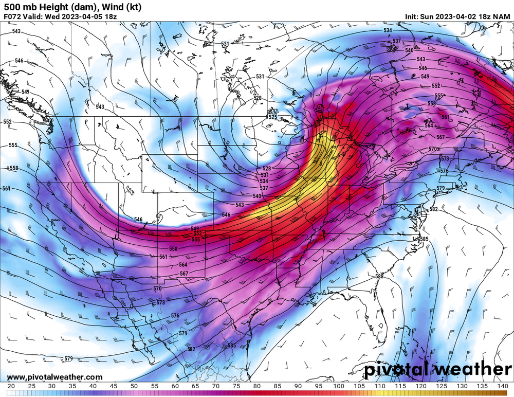
I'm seeing a parallel to the Apr 3-4 1974 situation shifted a bit to the northwest, so therefore it could be extreme on two consecutive days because in 1974 the second day's outcome was somewhat diminished by having much of the severe zone over the Appalachians to mid-Atlantic states by mid-afternoon (there still was a minor resurgence), in this case the explosive development zone would be further west on Tuesday 4th (similar to Apr 3 1974 but shifted northwest) and as with 1974 it would be very active all night then become prone to redevelopment but more so because the cold front would still be west of the mountains in the Ohio valley by 18z-21z. A two-day outbreak with an overnight component and extreme potential in a heavily populated region, has super-outbreak potential.
I fully expect to see high risk and PDS situations over all states from e KS to OH and e TX to GA, let's hope this either misfires or contains its worst cells to farmland because there could be quite a few long-track F3-5 cells involved in this.
Synoptically, this setup is different and not similar. This past outbreak actually had similarities and the analog was shown in the soundings. Just not seeing the similarities this time around.
-
1
-
-
9 minutes ago, andyhb said:
HRRR has problems with LCL heights early in MO, highlighting the concern with mixing (although it tends to be too aggressive with that).
I remember leading up to this past Friday, the HRRR had a few runs where it did that early on but corrected within 18hrs to the start of convection. Also not the first time I've seen the HRRR do this, seems to be a typical bias of the model.
-
6 minutes ago, RCNYILWX said:
I had a feeling that's what you meant, but wanted to clarify for those following the discussion. It's definitely a colloquial thing to call variance in the guidance on capping issues "struggling".
Regarding your second point, I'd say that it's fair to say higher end events likely had a strong EML and therefore needed some sort of wave to help break the cap if the large scale synoptic forcing (such as height falls) was lacking.
I've brought up April 7, 2020 because of how that event hinged on the cap breaking and there was decided variance on whether the cap would break and coverage of storms.
SPC outlooks seemed to largely discount the ECMWF for that event interestingly enough.
While Tuesday is not similar synoptically to that 2020 event, time of year, strong EML, and consistency of the ECMWF depiction are interesting parallels.
Sent from my SM-G998U using Tapatalk
Great analysis and comparison there. With the fail modes in place, April 7 2020 could be the floor. I still believe tonight's event was the "fly in the ointment" that caused the CAM to back off a tad with concerns to Tuesday. Interesting to note, the EURO stuck to the scenario and the RAP and now the HRRR are caving towards the EURO scenario. Will be interesting to see how tomorrow's convection impacts the environment for Tuesday.
-
Just now, largetornado said:
HRRR isn’t shy
That's a substantial trend higher with STP compared to previous runs. Seems like the CAM is having a better handle/grasp on Tuesday now that tonight's event is wrapping up.
-
2 minutes ago, RCNYILWX said:
I wouldn't necessarily call it struggling with the cap. It basically underscores the conditional nature of the threat with eastward extent in the late afternoon and early evening. There's good agreement on a fairly strong cap, but variance on whether there's a wave to break the cap. Without a short-wave, the convergence along the warm front alone likely wouldn't be enough to overcome the minimal forcing and height rises. We won't hit convective T with an EML that stout.
The fact the Euro has shown a short-wave and CI multiple runs in a row has my attention though.
Sent from my SM-G998U using Tapatalk
I should of chose better terminology when I said struggling. My apologies, but yes I am in agreement with that. Correct me if I'm wrong but the more high-end, severe outbreaks we seen in years past always featured a short wave out ahead of the dryline, early day surface low or mcs, to help breach the cap and lay down boundaries to set off convection.
-
1
-
-
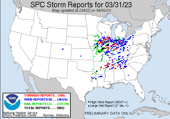
Factor in the stuff from 3/31 and yes. But concerning 4/1, there's a gap in central PA where there were no wind reports.
-
Here's another potential thing to think about. The "fly in the ointment" was tonight's event when models started to show a much more significant event for today they backed off for Tuesday. Considering tonight's event underperformed, I wonder if the models will start to go back to a more high end solution for Tuesday with these capping issues and mixing/lcl issues resolved.
-
6 minutes ago, RCNYILWX said:
*If* the cap breaks as the Euro is showing, the parameter space is high end. For those who recall the wind blown sig hail event on 4/7/20, it had CI pegged for that setup from 6 days out and locked in. It's recently been the most robust with the 500 mb short wave and speed max, enough for CI between 21z and 00z.
Because the cap is rather stout, I wouldn't lock in the Euro depiction playing out, but it's interesting that's it's latched onto that scenario. If I were drawing up the outlook for the DVN, LOT, MKX CWA border region and points east, would probably go 15% hatched hail, 15% wind and 2-5% tor. Conditional, but potentially higher end setup late Tuesday afternoon into Tuesday evening, in the 21-03z timeframe.
LCLs look a bit marginal for higher tornado probs, but warm front proximity suggests anything close to the front would have that potential if a couple storms go.
[i was on a spring break ski trip last week, though I'll be around and working day shifts this week to add to the discussion. Last Friday was one of the few significant severe events in the LOT cwa that I've missed since I've been out here.]
Main issue the models been struggling with is the cap. Some models like the RAP now showing the cap being breached hours before sunset. EURO been showing this however. Others like the NAM and HRRR breach the cap at or just after sunset. Interesting to point out, both the EURO and RAP are different in how the cap breaches.
-
5 minutes ago, Paulie21 said:
FWIW the 21Z RAP is basically just last Friday lol. Stronger LLJ remains in W IL but the sfc flow is far better in E IA. Gonna be another split between everyone sitting in Galesburg vs Iowa City. Pick your poison.

Big tick upwards in parameters on the RAP. NAM seems to be trending to that scenario but still holds convection off until around sunset like the HRRR. This is a promising "potential" trend by the RAP.
-
2
-
-
Confirmed tornado by weather spotters, north of Kosse
-
23 minutes ago, Chinook said:
Dallas has a 64 dew point, up from a dew point of 17 yesterday (2:53AM on April 1st). It's just amazing how that works.
That is a rather impressive increase in dew points in short order.
-
1
-
-
6 hours ago, PowellVolz said:
Holy smokes
.Perfect, instructive video to show the public that when the NWS or us forecasters warn of a tornado, there is a reason we say "seek shelter". That means away from windows, doors, exterior walls, etc. and in an interior room like a closest, in a basement, or a storm shelter. Your life is not worth the picture and video, going viral and gaining "5 minutes of fame".
-
1
-
-
10 minutes ago, andyhb said:
That is classic for a significant Great Lakes severe event. Timing/destabilization pending of course.
There is a few noticeable trends I'm seeing leaning towards the prospective of a more significant threat. Previous NAM runs struggled to present any sort of mechanism to fire convection east of the dryline. NAM seems to be more vigorous with the surface low coming out of the southern plains and has it deepening to 988mb. The pivot of the low cutting north is timed right when the trough orients negative. Convection looks to fire around sunset or after along the dryline. Not liking the timing of that because it suggest bulk of convection holds off until near sunset when the cap is breached, when the LLJ cranks. Though there will be convection across the lakes on Tuesday, it looks as if this is becoming more of a Wednesday event.
-
5 minutes ago, hlcater said:
It’s not hard when the storm is easily S tier and probably the best Iowa supercell since 4/9/11. Pella comes close but as someone who was at both, this beat Pella.
Will obviously need to wait for the rest of the year but I expect Keota in particular to be a serious TOTY contender.
I say that I would love to see them, because I’m a storm chaser based in the Mid-Atlantic. I have come close a few times chasing here in VA though.
-
35 minutes ago, hlcater said:
A bit late, but I worked at 11pm last night and again at 3pm today so my whole "post chase" process is a bit delayed. Don't have much to add off of what has already been posted but I started the day in Mt. Pleasant and planned to just kinda wait and play the field with the developing supercells. The wave in the morning was still a bit stable and while they were supercellular aloft, they were not surface based so I did not follow them east. I drove to fairfield to wait for the storms to the south and west to mature and ultimately chose the storm that would track near Ottumwa as it was obvious on radar/vis that it was the dominant storm. Perhaps due to some Winterset PTSD, I chose to stay miles and miles ahead of the storm and instead of close intercepts, planned my routes with keeping up in mind. Still, these were some of the most visually impressive tornadoes I have seen. Especially the Keota EF4.

Hendrick tornado while it was in full swing from miles away.
Handoff near Keota.
The Keota tornado about as it was doing EF4 damage. This may be my favorite shot I've ever taken.
Again as it was approaching Wellman. Big dusty wedge for most of its life. For those familiar with 2/28/17, think of it as Washburn on steroids.
Dude, absolutely impressive. You and every other chaser out there did great on the pictures and videos. I would love to witness/experience twin tornadoes.
-
2
-
-
1 minute ago, Malacka11 said:
The NAM was massively west with yesterday too if I remember right no?
Yeah, like i said earlier, the NAM suite has been off this storm season. It was horrible with the last 2 outbreaks and outperformed by the other models. Its doing the same thing, like you said, it did with yesterdays outbreak.
-
2
-
-
46 minutes ago, Quincy said:
Strong synoptic signal, but not sure I’d be calling for a high risk this far out.
Agreed. Between mixing, LCL's, morning convection, capping inversion issues this is something we wont know until the morning of, in terms of SPC issuance. But this is the strongest synoptic signal we have had for a severe weather outbreak since 2011 over such a large area/expanse of the US. It's shaping up to be a conus-wide outbreak.
-
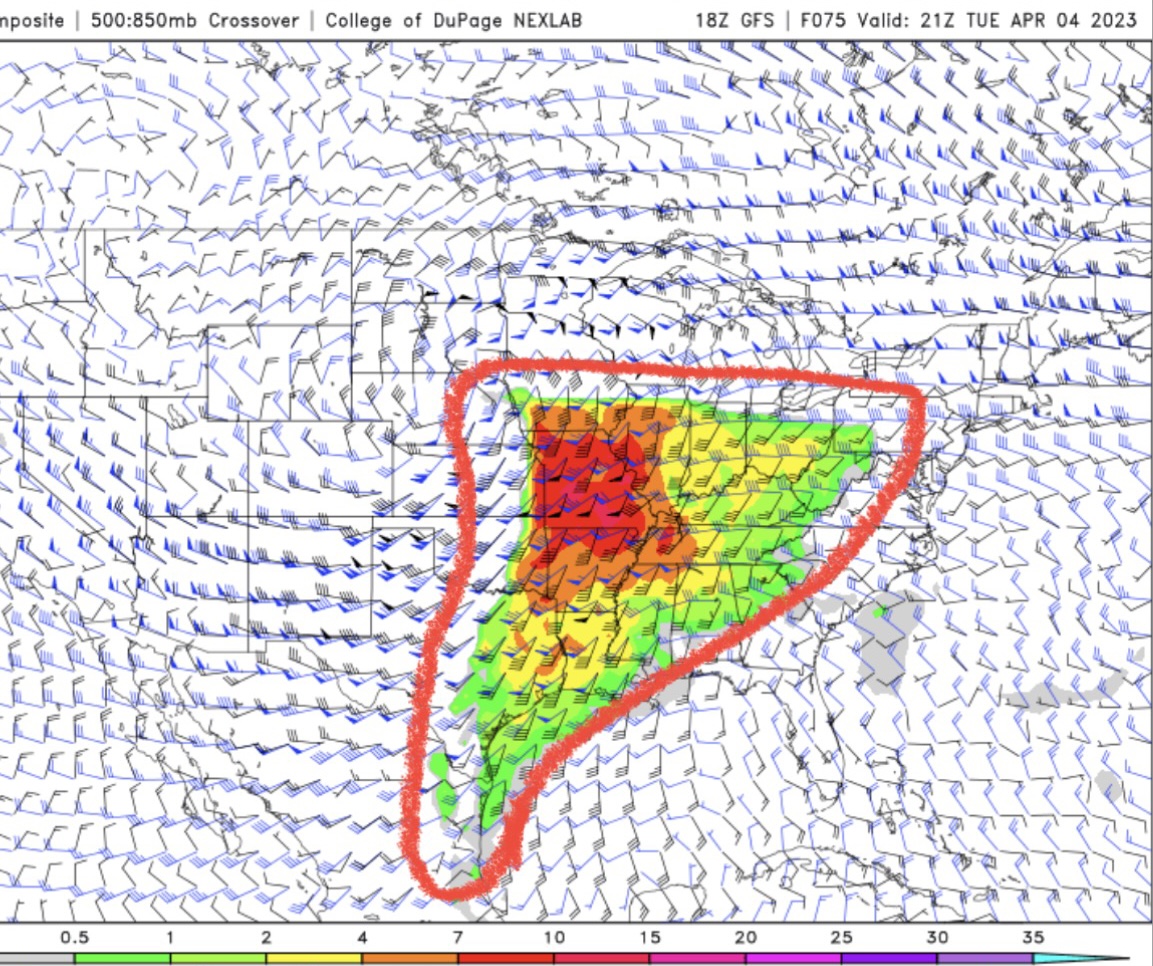
Looking at the GFS, these are high end Supercell Composite values being we are 80hrs out. The size of the warm sector is unreal.


2023 Short/Medium Range Severe Weather Discussion
in Lakes/Ohio Valley
Posted