

WxSynopsisDavid
-
Posts
430 -
Joined
-
Last visited
Content Type
Profiles
Blogs
Forums
American Weather
Media Demo
Store
Gallery
Posts posted by WxSynopsisDavid
-
-
The one good thing here is we have a few fail modes being presented. In all honesty, that is digging for something positive right now because the current fail modes still yield a sizeable outbreak.
-
Looking at the soundings, they are all high-end upper echelon type stuff. If you get past the small issues the NAM has been dealing with this year, those NAM soundings are still high end. As has already been discussed, the main issues here at this point remain: mixing, LCL's, early morning convection, capping inversion issues. Should those issues materialize, the floor would be yesterdays event. If we do not have any of those issues come Tuesday, this outbreak "COULD" rival the scope and magnitude of some of the bigger outbreaks we have seen. I know a lot of people on Twitter been throwing around 4/27 comparisons for size, and its very plausible the warm sector gets into southern Canada, its important to note for size/magnitude that can be debated. Everything else, no. Yesterdays event was close to some degree, a smaller "notch down" carbon copy of 4/3/74. Same areal coverage, same upper air support, but not quite on that level with violent tornadoes. I will say that I am more concerned for this upcoming outbreak than I was with yesterdays...and I still had concerns, not just as many as I have for this next one.
-
46 minutes ago, andyhb said:
One limiting factor with this may be mixing if we get near the progged high temperatures from some of the models. LCL heights would be an issue.
NAM suite is suggesting a strong cap in place in some areas that don't get breached until right before sunset. This would need to be monitored as it would suggest, if parameters hold, this would be a nocturnal event.
-
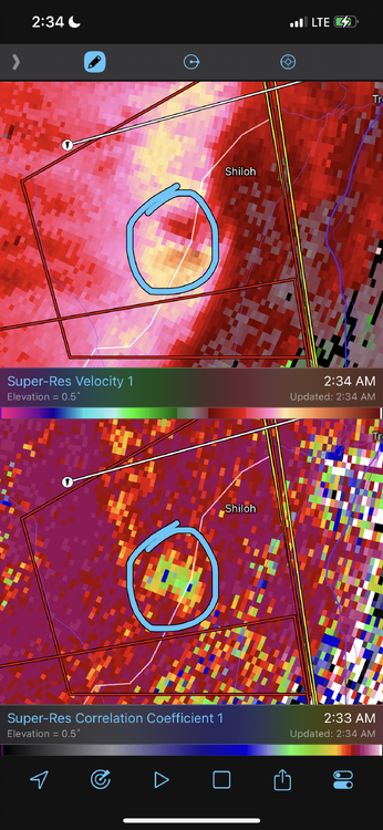
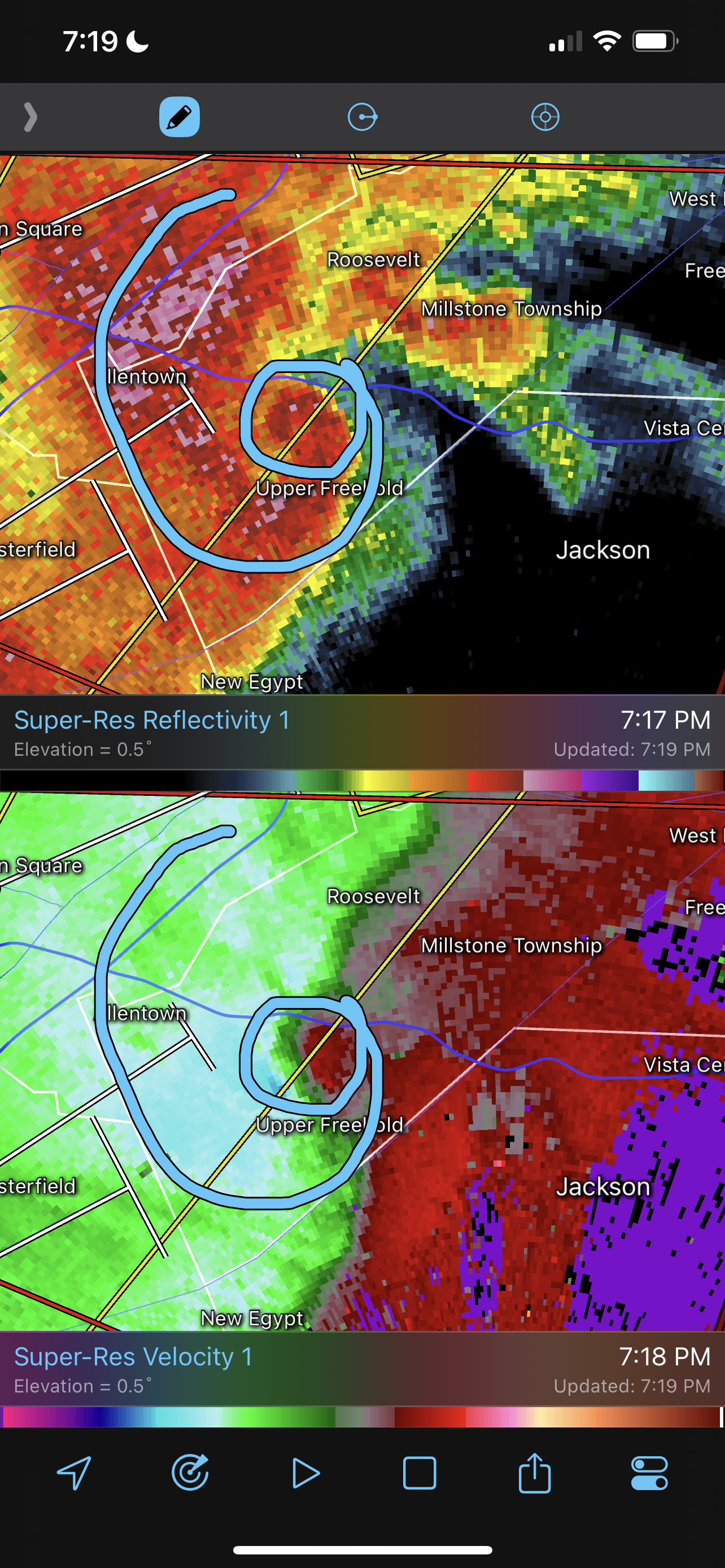
Absolute textbook of an embedded hook echo. Very rare to see this signature in the northeast.

-
1 minute ago, andyhb said:
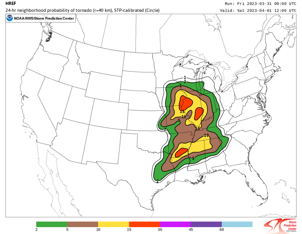
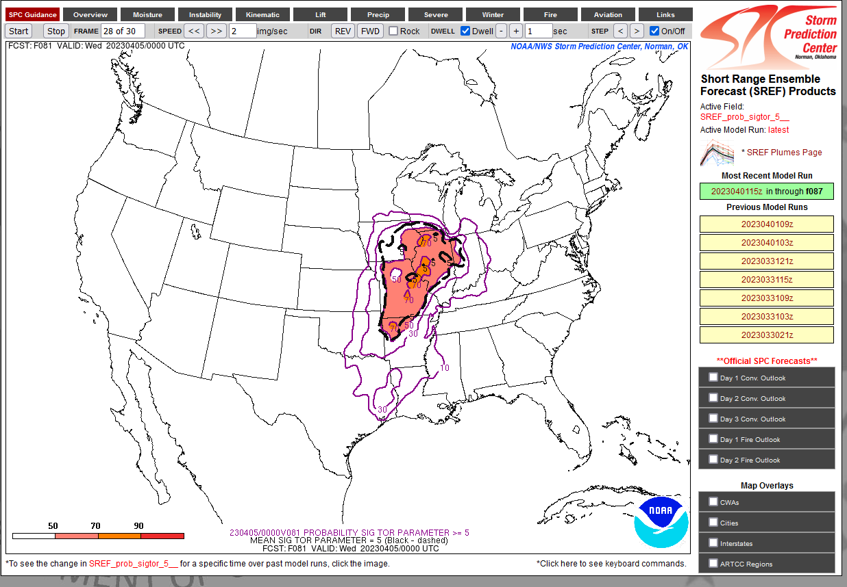
Amazingly high probabilities of STP ≥ 5 over a large area for Tuesday 81 hours out from the 15z SREF. Never seen anything like that at this range.

There were similar trends at this range for the 3/2/2012 and 4/27/11. But you are right, this doesn't happen often and its rare.
-
1 minute ago, Stebo said:
RRFA model did very well with both events, it will be interesting to see how it performs as we get closer to Tuesday.
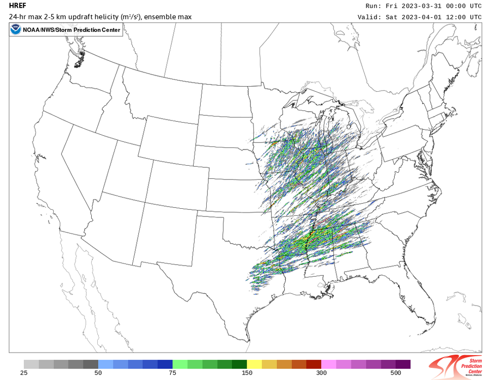
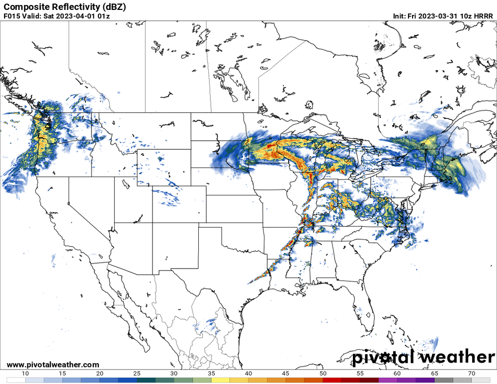
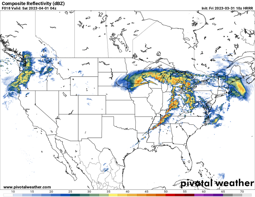
Yes it did, it was probably the most accurate in terms of how it depicted the warm sector and the airmass recovery between the waves of discrete. Also, while other models were trying to congeal the stuff quicker to the south like in Arkansas, the RRFA kept everything discrete or semi-discrete. The helicity swaths it outputted yesterday morning was almost a carbon copy of what was experienced. The HRRR has also done great with these last 2 outbreaks too.
-
 2
2
-
-
1 minute ago, andyhb said:
That's at 03z and also I have strong doubt that it is going to be 66 degrees at that time given the magnitude of WAA with this trough. NAM tends to be cold biased.
Important to note that the NAM suite was horrible with yesterday's outbreak and was also horrible leading up to the Rolling Fork incident. NAM suite has been getting out-performed this year.
-
1
-
-
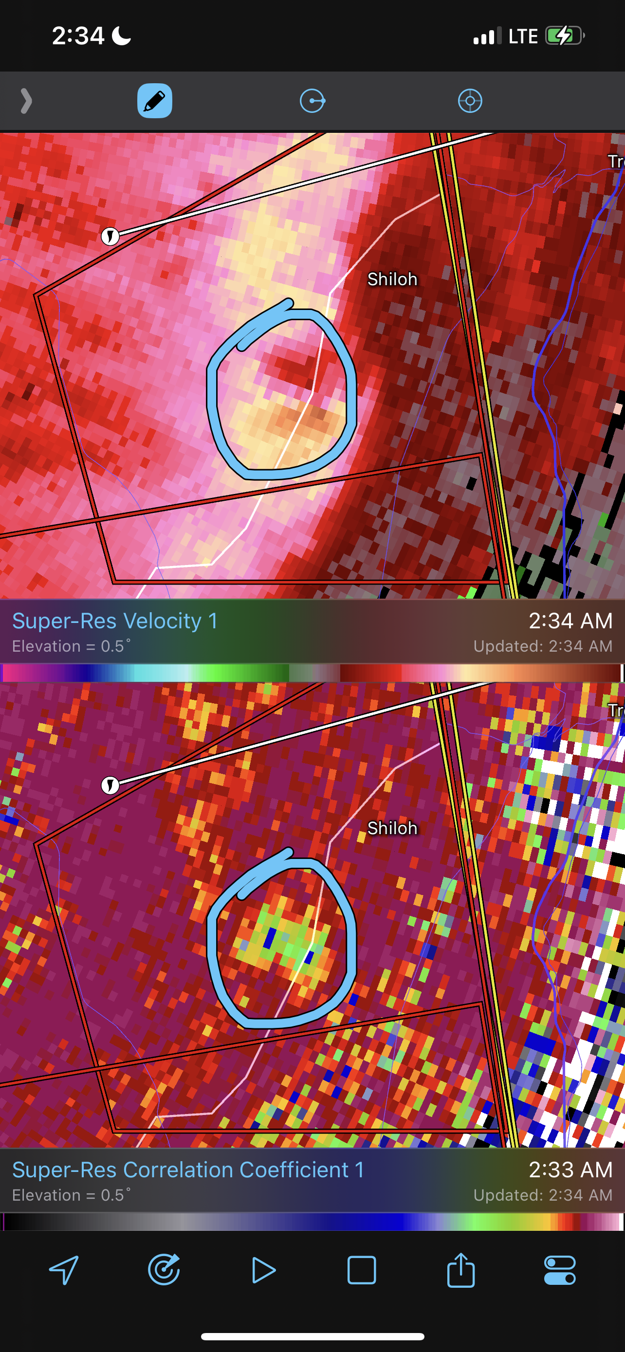
Radar velocity scans were showing 3 couplets with TDS. That was a potential trio, one of them would of been rain wrapped.
-
36 minutes ago, cyclone77 said:
This thread seems quieter. I'm not able to look at models much atm, is this setup still looking as impressive?
We are all focused on the current, on going major outbreak. There will likely be no post made until after this current outbreak is over.
-
 1
1
-
-
Confirmed by Brandon Copic, dual tornadoes on the ground near Keota
-
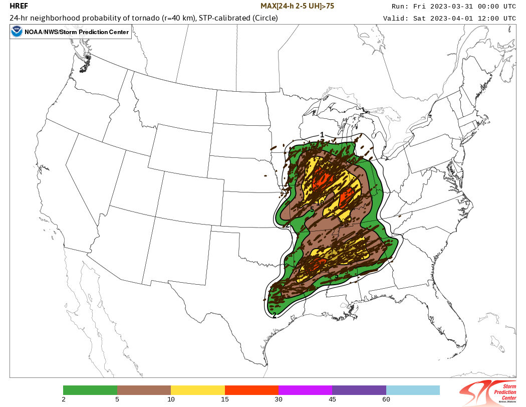
The 00z HREF spits out a “super outbreak”. Curious to see the next updated HREF run.

-
2
-
2
-
-
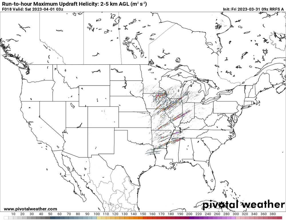
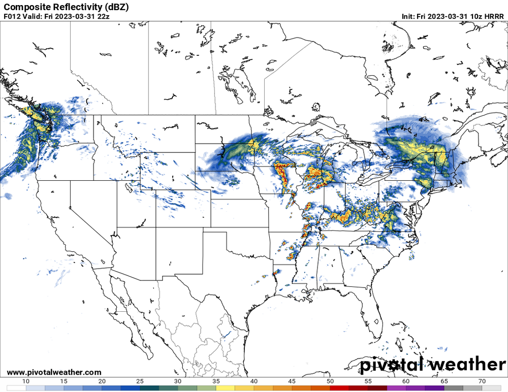
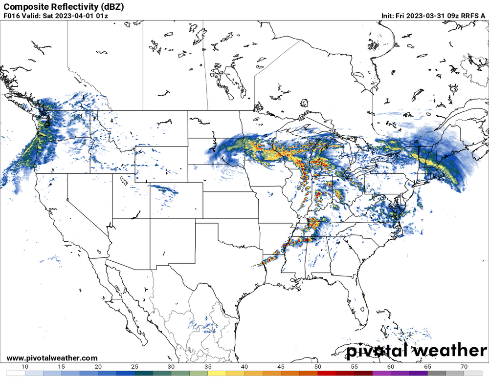
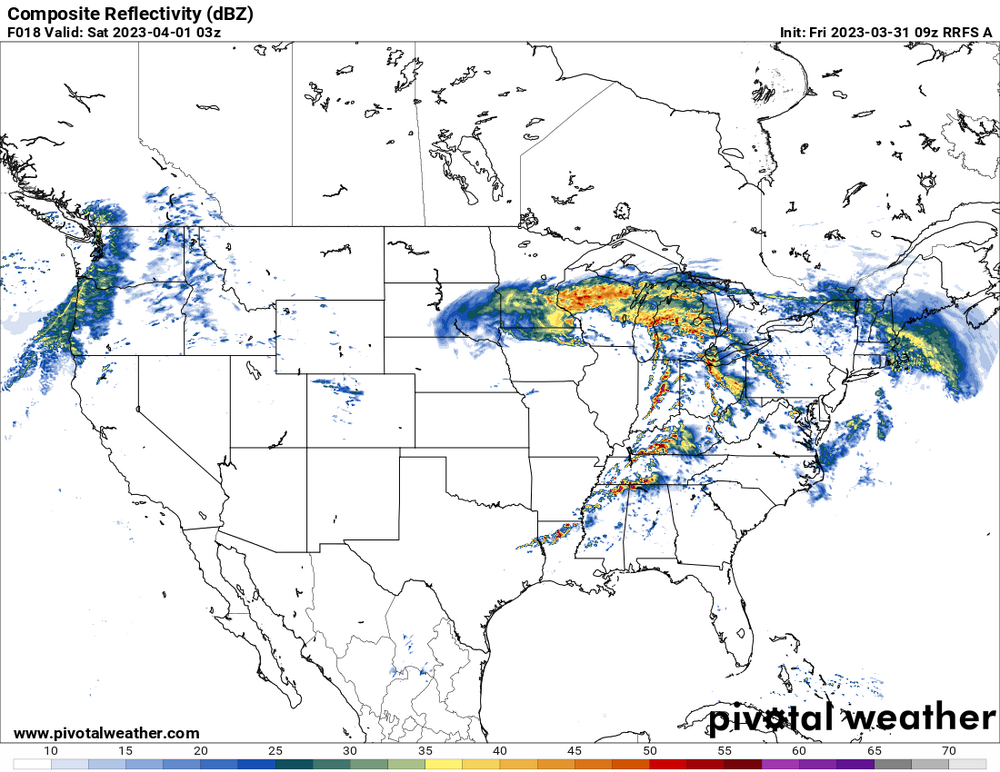
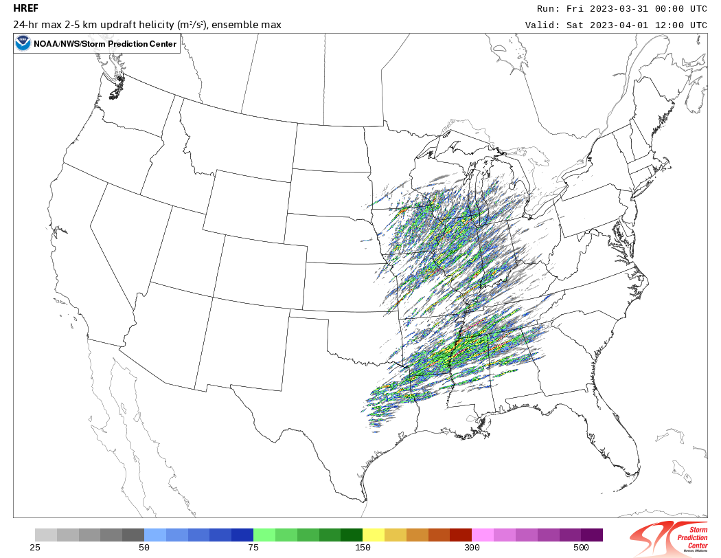
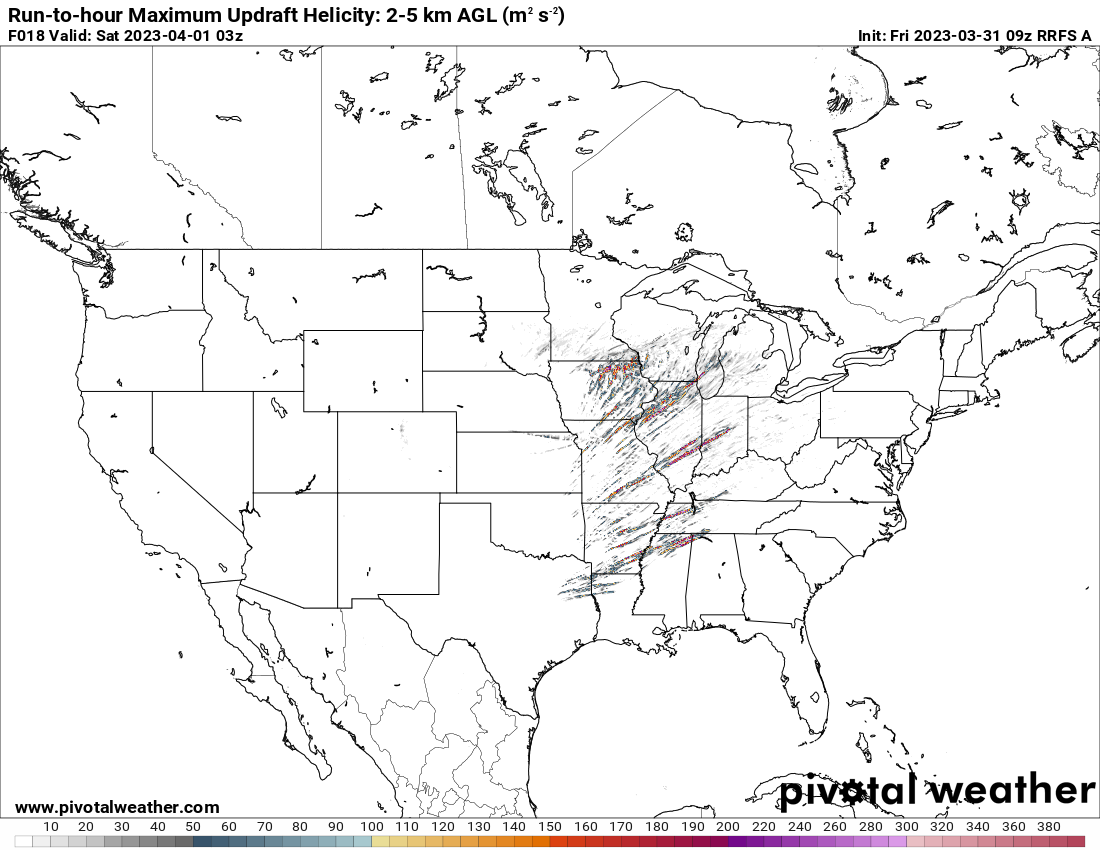
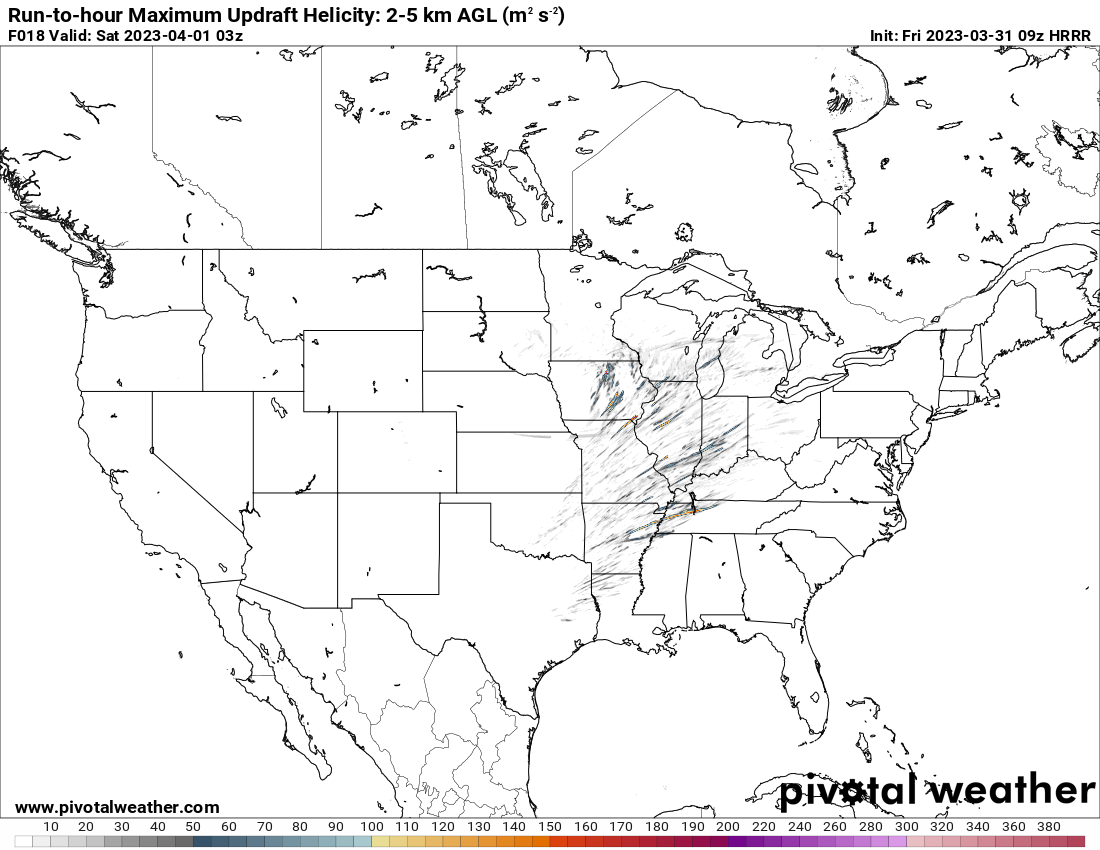
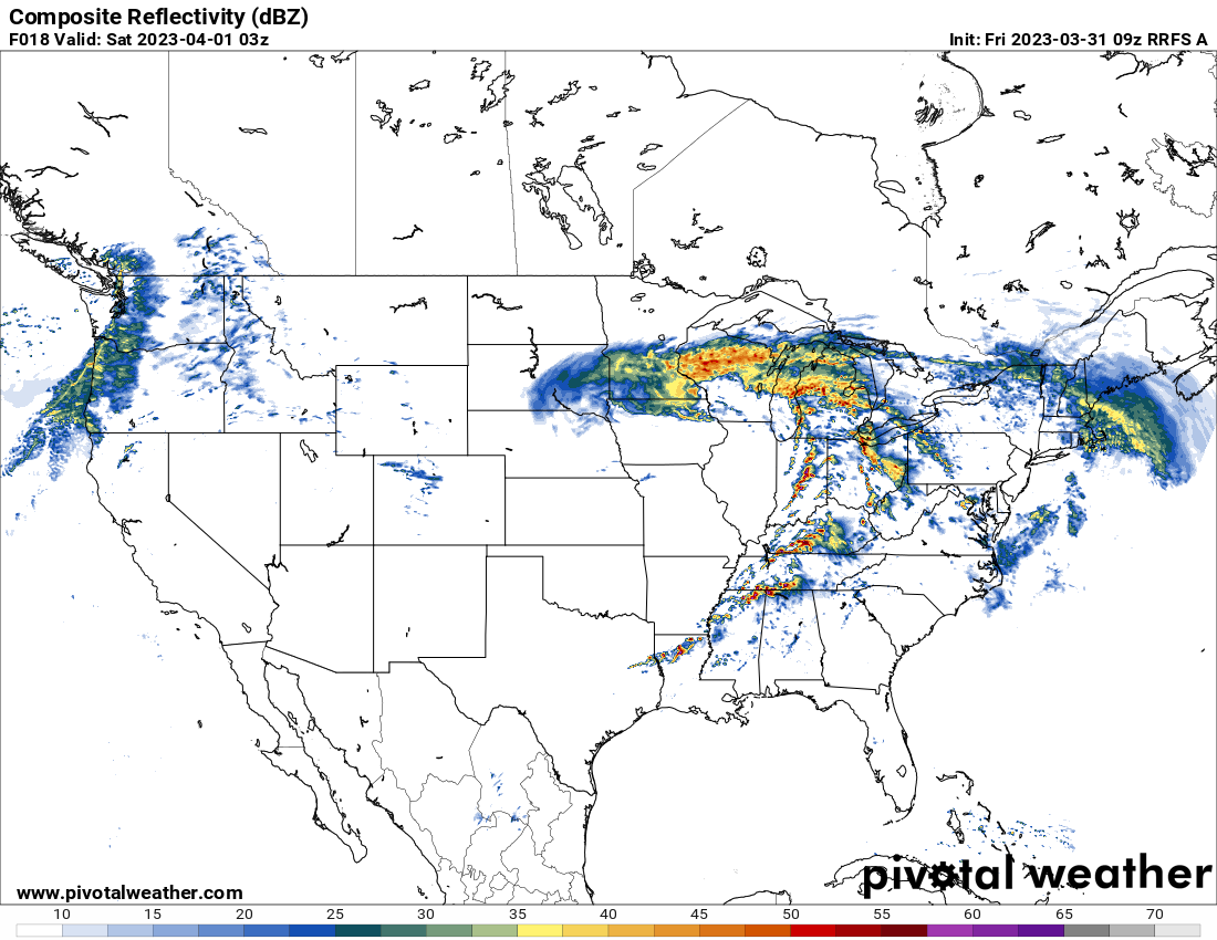
09z RRFS-A and 10z HRRR helicity swaths

-
2
-
-
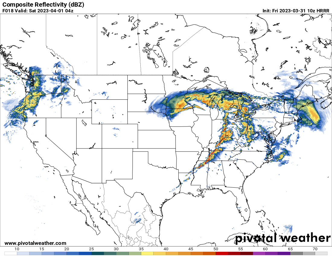
10z HRRR
-
09z RRFS-A is insane, don’t really have the words to describe that scenario. About as high end as you can get. Even tries to get some supercells going out east from northern VA up into PA.
-
7 minutes ago, A-L-E-K said:


-
 1
1
-
-
15 minutes ago, stormdragonwx said:
Pivotal Weather released an interesting new CAM model to their data feed. The RRFS A. It shows a pretty ugly situation for central and eastern AR by early afternoon tomorrow.

That is pretty extreme. Between the HRRR and the rest of the CAM, this is as an extreme/high-end as you can get outside of a super outbreak scenario. The parameter space and warm sector is indeed impressive.
-
2 hours ago, Kaner88 said:
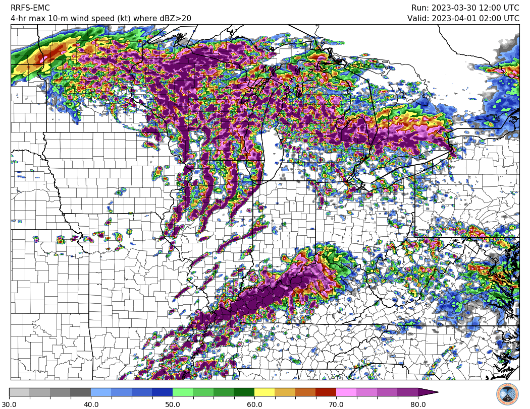
Just don't feel good about the potential for north-central / northeast Illinois. Taking models verbatim, we have potentially widespread, potentially strong storms plowing through the area in the morning hours, almost totally overcast skies through the balance of the day, and yet somehow we still end up with over 1000 j/kg CAPE? I get the very impressive dynamics of the system, including similarly-impressive unstable air advection on northwards, but a daytime high in the area somewhere in the low/mid-60s with extensive cloud cover and substantial early-morning convection never feels very good.
Assuming model guidance is right and I'm dead-wrong (more likely than not), though, I'm super concerned about damaging winds in the Chicagoland area. Storm movement per LOT potentially over 60 MPH plus the aforementioned dynamics of this system lead to some eye-watering images like this ... maximum 4-hour swath 10m winds showing pretty large swaths of >80 knot (~92 MPH) winds with this line. Pretty much a worst-case scenario type of graphic, of course, but does give a sense of what mets & others here have discussed re: significant severe potential.
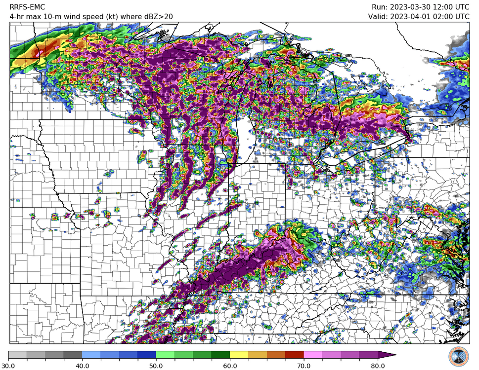
Dynamics can compensate for lack of instability (high shear/low cape outbreaks). In fact some of the higher end, more substantial outbreaks have featured such setups. Though I live in the Midatlantic (Virginia), I can testify that overcast and 60f temp means very little in the way of hindering the setup. I chased the 2/24/16 outbreak here in VA. There was an overcast all day and temps were bouncing between 50-70 all day. 2 devastating high-end EF3’s struck Appomattox and Essex. Also, our state record tornado that struck Petersburg on 8/6/93 was a high-end F4. That day also featured an overcast and thick cloud deck.
-
2
-
-
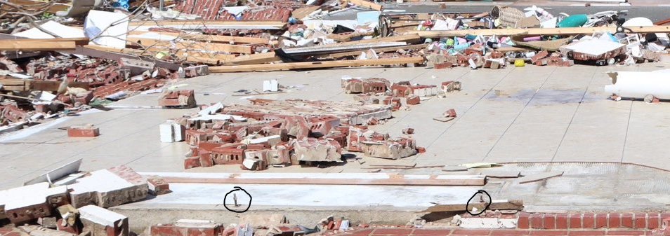
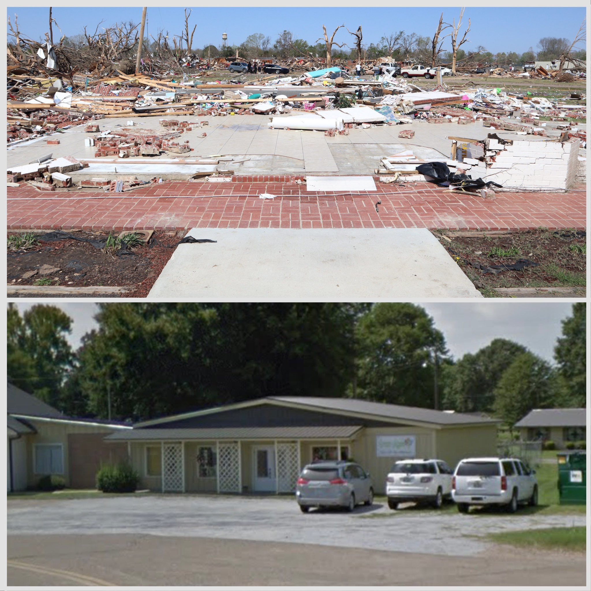
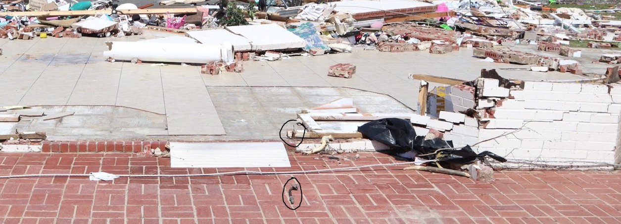
Florist shop in Rolling Fork, made of brick, completely slabbed. Most of the slab was wiped clean. One of the anchor bolts was completely removed from the slabbed and bent. Also notice the tree damage in the background.


-
2
-
-
3 hours ago, marsman said:
In his video there are mentions it could be a drone (ffwd to 1:28): https://www.facebook.com/TornadoChasing/videos/590247399819779/
Let’s hope it was a drone
-
6 minutes ago, SluggerWx said:
Large CC drop in far northeast AL at the moment.
It looks like a tornado hit something in Sulfur Springs, AL as the CC really gets large due west of town as it tracked towards Overlook, AL.
Sent from my Pixel 6 using Tapatalk
-
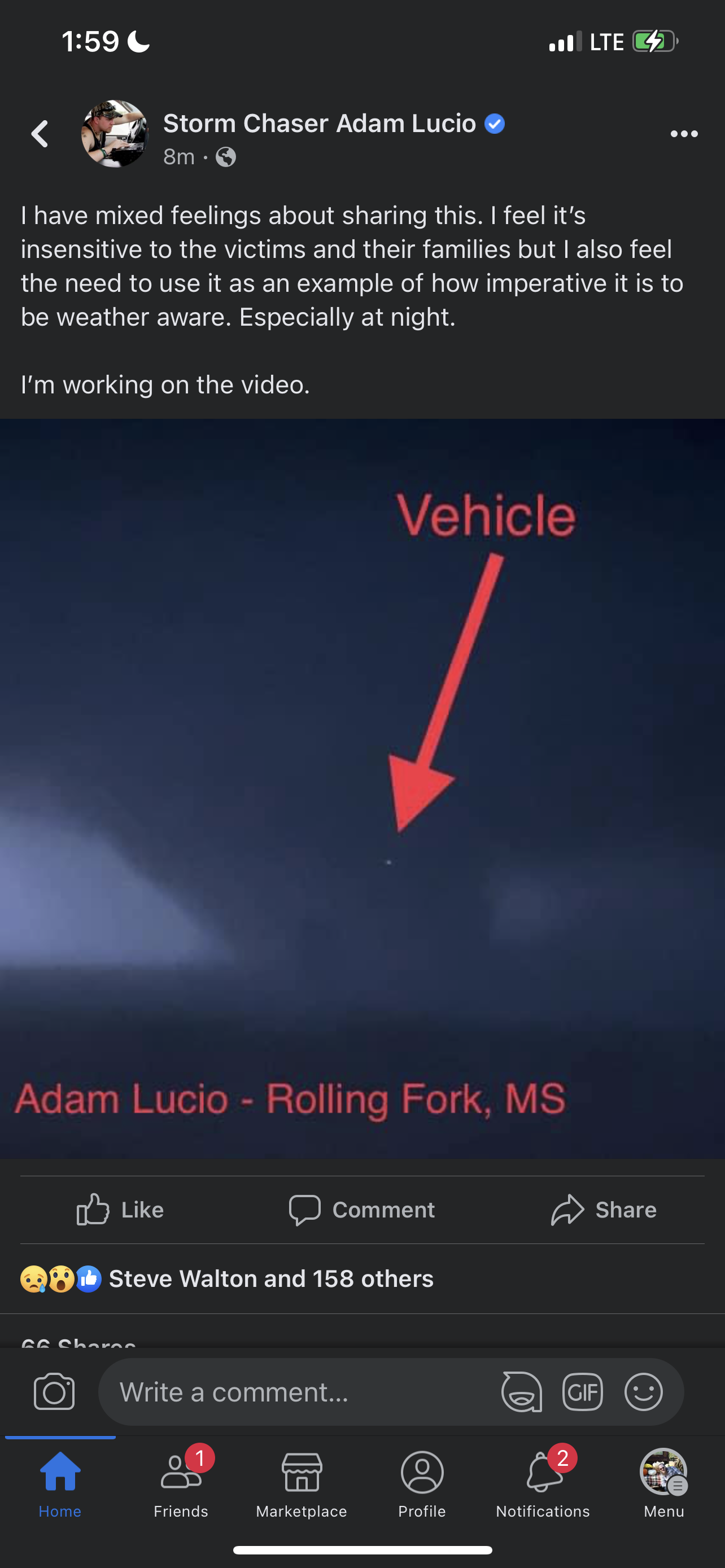
A vehicle got sucked into the tornado and lifted into the upper most portion of the vortice. Adam Lucio has video of the vehicle getting sucked into the vortice, won’t share it due to sensitivity but here’s a screenshot of the vehicle going up into the upper most portion of the vortice.

-
 1
1
-
-
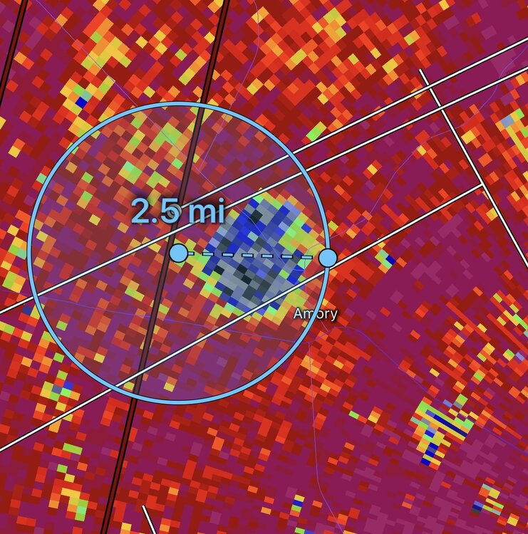
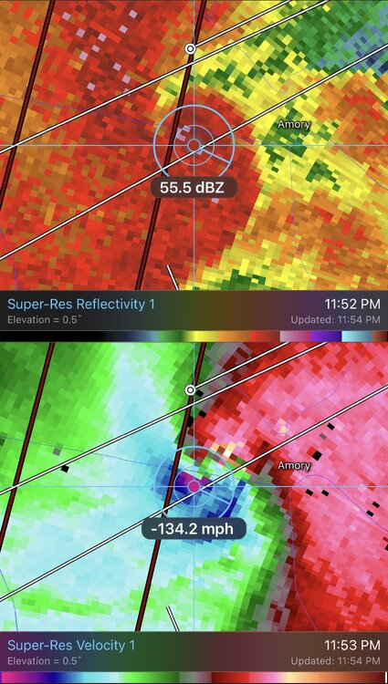
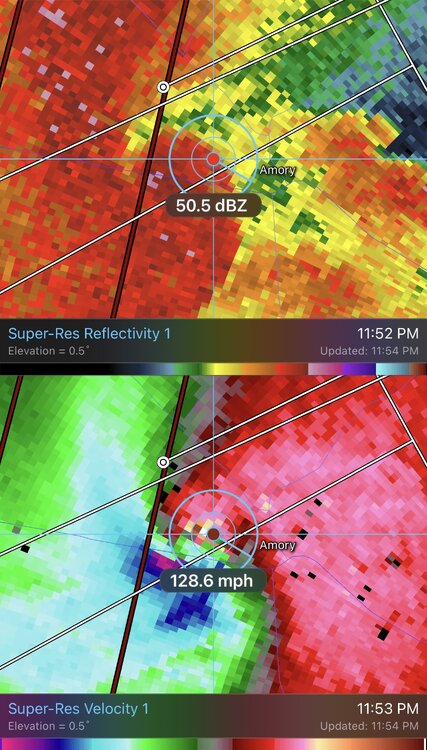
8 minutes ago, Quincy said:
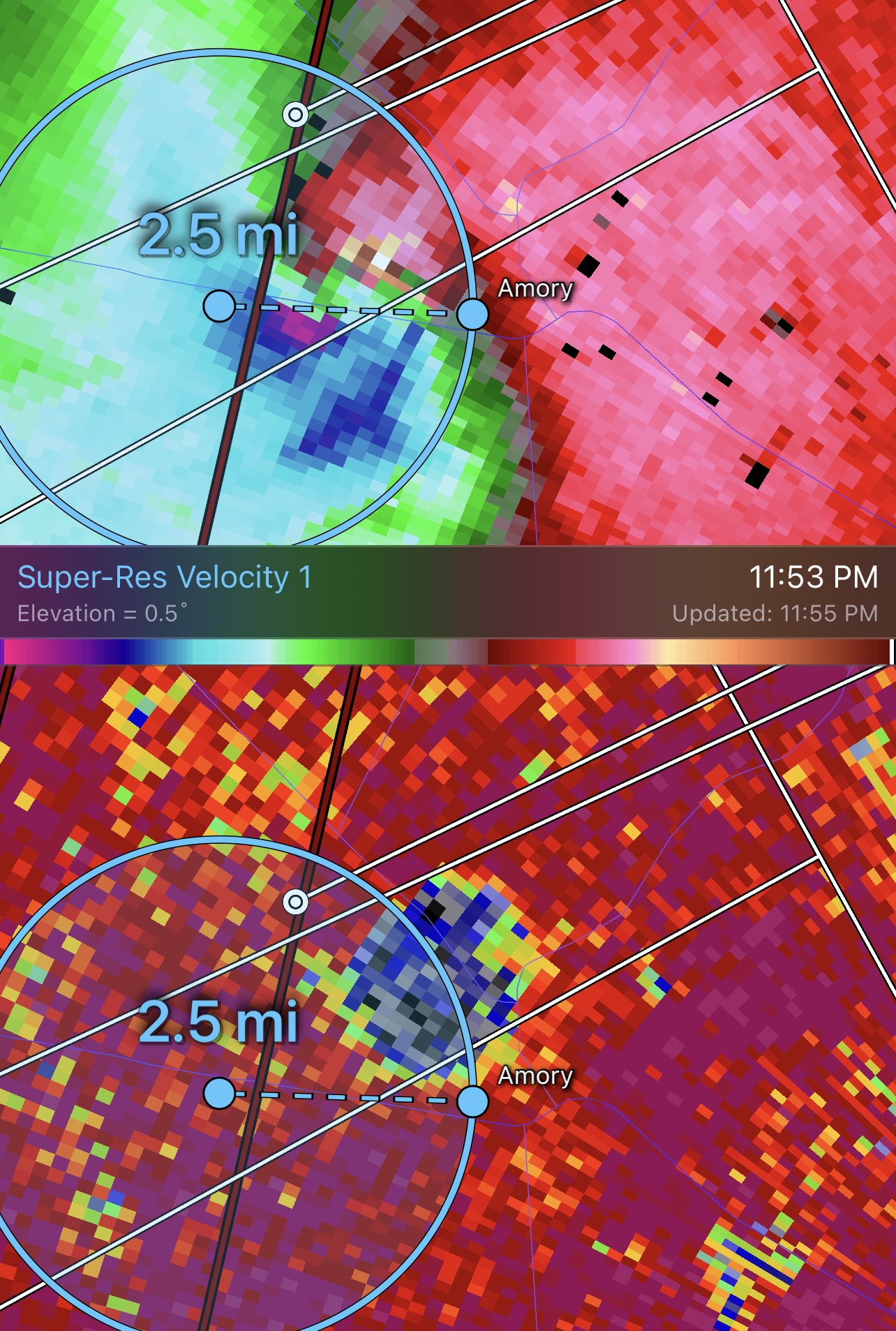
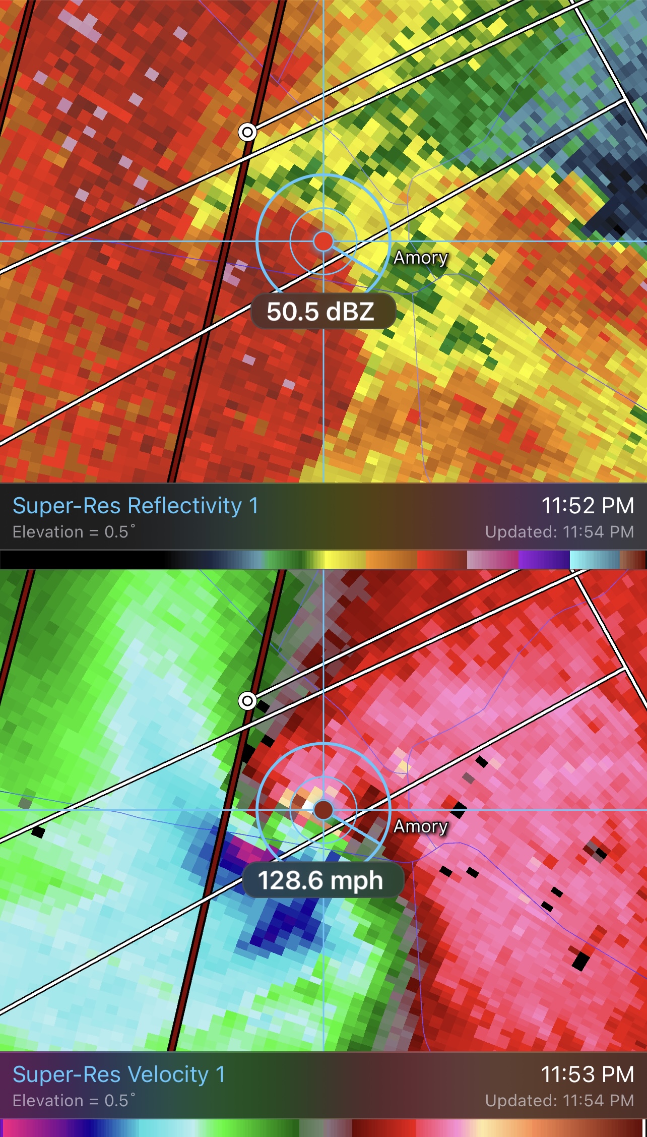
It’s also very close to the radar site, so we’re getting lower scans that we don’t often see with intense tornadoes. Undoubtedly EF-3+.
The fact it was close to the radar yet still getting 260mph+ velocities is ridiculous.
-
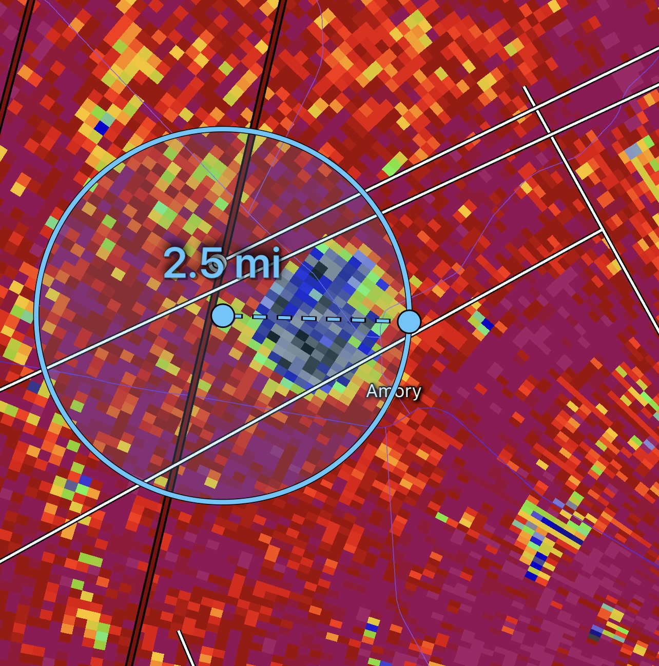
Both the debris ball and couplet exceed 2.5mi in width. This is a potential record tornado in progress for width and a potential top-5 violent tornado in terms for velocity. Really hope this isn’t mixing to the surface but given debris is exceeding 40,000ft it’s likely this is an EF5.

-
 2
2
-
-
Wow….260mph+ gate to gate. It’s been a very long time (since Moore and El Reno 2013 EF5’s) that Ive seen radar velocities this extreme.


2023 Mid-Atlantic Severe Wx Thread (General Discussion)
in Mid Atlantic
Posted
New Jersey