

WxSynopsisDavid
-
Posts
430 -
Joined
-
Last visited
Content Type
Profiles
Blogs
Forums
American Weather
Media Demo
Store
Gallery
Posts posted by WxSynopsisDavid
-
-
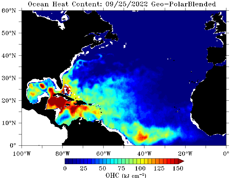
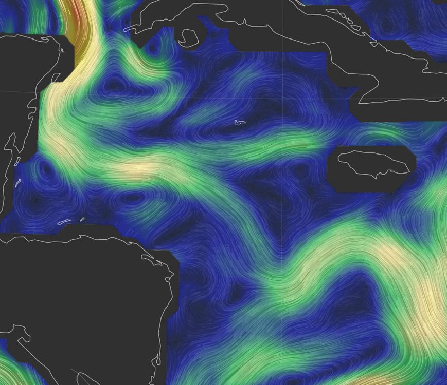
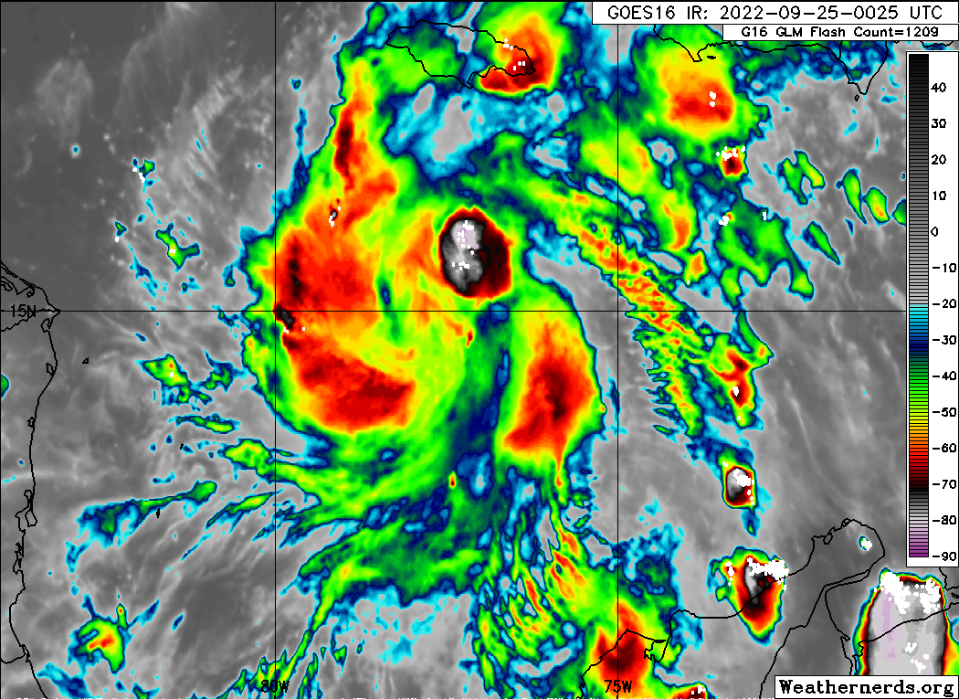
Looking at the environment ahead of Ian tonight, besides the lack of dry air and windshear the OHC is very high ahead of this system. Also, something to note here, there are a few warm eddies ahead of Ian so its very possible this anticipated RI process could lean towards an "explosive intensification" process once Ian gets an established CDO and eye. Its also now following the tail end of the loop current so we should start to see remarkable/appreciable structure changes soon.
-
 1
1
-
-
8 minutes ago, StantonParkHoya said:
Euro about 50 miles west, pretty similar to GFS.
We may finally be getting a good idea on Florida target.
Until Ian gets better organized and we see an eye develop, we wont have any better idea in the long term and neither will the models. Expect additional back and forth in terms of track until then
-
Just now, SnowenOutThere said:

If that blob takes off we are off to the races tonight."The little engine that could"
-
Just now, Amped said:
This is similar to what Harvey, Delta, and Micheal did. All had a sudden convective burst that dropped the pressure from about 1003mb to 990mb in a few hours.
Exactly, which draws into perspective that Ian is deepening at a much faster rate than what was originally forecasted and shown by the models. This is going to be huge/detrimental to the forecast track so I expect further adjustments on the models tonight.
-
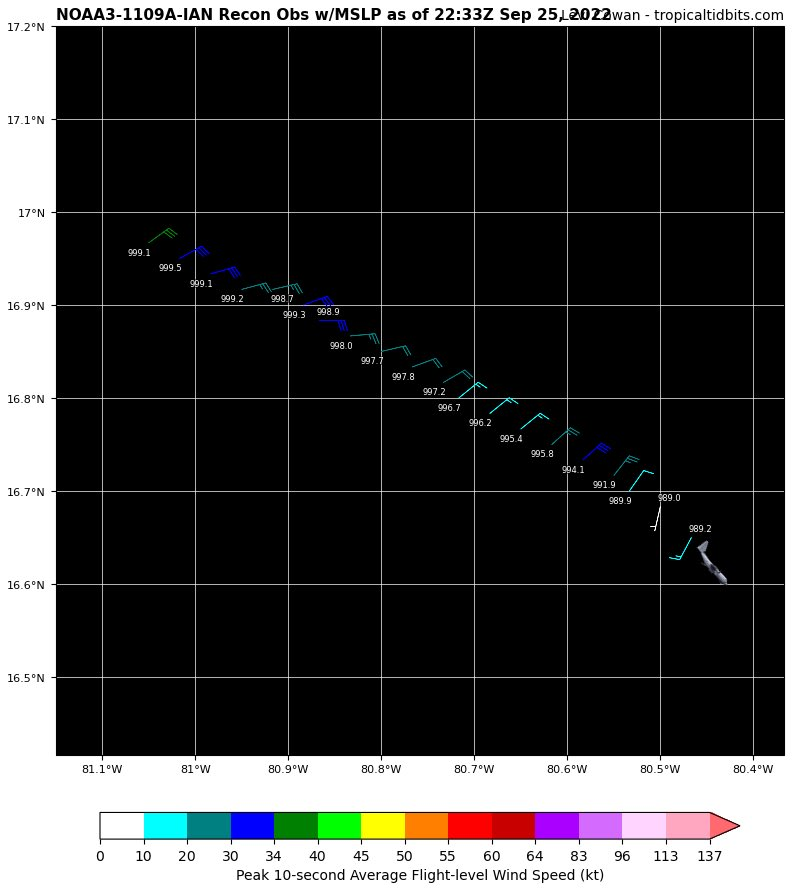
990mb currently, that is a 15mb drop in 5 hours. Very certain we see hurricane force winds at the surface in the next several hours once convection gets going

-
Ian down to 990mb, looks to be a temperature spike near the center too. We are likely about to see convection rapidly going up near and around the center very shortly
-
To you guys who live in Tampa Bay, I wish you guys the best of luck with this storm and I hope you all fare better in the long term then what we are seeing.
-
 3
3
-
-
Just now, MattPetrulli said:
Surge will be bad, but lets not under estimate the potential for a Cat 2-3 eyewall to be going through Tampa. They have great building codes but that would cause significant damage regardless.
...and a prolonged wind event at best.
-
A better option at this point for Tampa Bay would be if this thing can landfall vs a potential stall off the coast. Both scenarios will be bad but the landfall scenario would probably be the best case scenario at this point. Hard to fathom the disaster this would be
-
1 minute ago, wxeyeNH said:
I use Weatherbell for model info. Great product. I am not sure how accurate the GFS wind products are, but this is the wind gusts in mph when Ian makes it closest approach to Tampa (18Z). It almost stalls in this position at around 967mb bring strong south winds into Tampa Bay.

That is going to be absolutely nasty for Tampa Bay with storm surge going up into the Bay with nowhere to go.
-
1
-
-
Just now, WxSynopsisDavid said:
I'm talking about past events and how the GFS handled them. This is typical GFS
Ultimately the storm speed/trajectory is going to be determined by the trough sweeping south too as well as the evolving blocking pattern.
-
1
-
-
Just now, StantonParkHoya said:
The trough position really hasn’t change, it’s more storm speed/trajectory
I'm talking about past events and how the GFS handled them. This is typical GFS
-
1 minute ago, StantonParkHoya said:
Kind of lurches it around to a Big Bend landfall
Yeah I would say the GFS is out to lunch on this one. GFS tends to struggle with these Florida canes because it either likes to slide the trough out quicker or it holds it back longer. GFS never really depicts these troughs right.
-
1
-
-
Don't agree with the GFS wanting to take Ian on a slow craw up the western FL coastline. Really think this comes ashore near Tampa or just to the north of Tampa. Either way, whether this landfalls Tamp or it slow crawls, both scenarios paint a disastrous storm surge/pro-longed wind event for Tampa Bay.
-
1 minute ago, Big Jims Videos said:
I'd call that a significant jump east on the GFS. Tampa evacuations should prepare like....tonight.
Very concerning, that slow creep on approach and near stall right off the coast of Tampa would be a huge storm surge disaster for that area. Definitely not good by any means
-
7 minutes ago, turtlehurricane said:
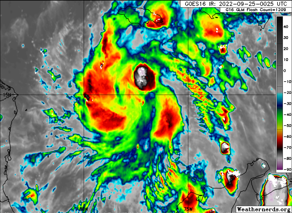
correct, not the classic definition of RI where an eyewall wraps around the center. However, partial eyewall formation likely beginning and the establishment of sustained deep convection.
In addition, when looking at satellite loops the outflow is improving at a rapid pace.
-
Btw....just an FYI....not sure if anyone is following Super Typhoon Noru but it just completed an explosive intensification process that saw it gain 85kts+ in the last 24 hours. Upper echelon event for intensification processes worldwide
-
4
-
 1
1
-
-
3 minutes ago, StantonParkHoya said:
Also a narrowing of the envelope from PC to Big Bend.
It all comes down to Cuba. What happens after it passes Cuba.
-
1 minute ago, bugalou said:
We have a chance to see two record RI's within 24 hours of each other in 2 different basins if Ian can get cranking over that bathtub water south of Cuba tonight.
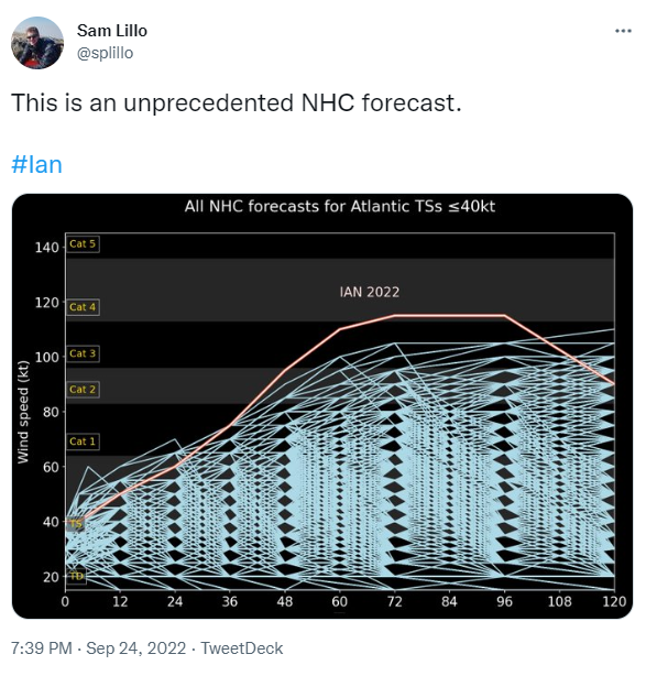
Its going to be a stretch if it can rapidly get organized and establish the CDO. The main window for RI we were anticipating was tomorrow evening into Monday morning. If it can get going tonight it will be ahead of schedule on the intensity forecast and most likely lean on the high-end side of the forecast outlined by the NOAA NHC.
-
5 minutes ago, Normandy said:
This might be the formative stages of the CDO. Big convection going up.
Oh most definitely, very impressive how quick this is happening
-
3 minutes ago, coastal front said:
Ian is starting to tighten up and with d max should see some explosive rotating hot towers overnight to really set the stage for RI.
New convective burst rapidly going up near the center. This is likely the start of things to come over the next 24-36hrs so I completely agree with your analysis.
-
3
-
-
7 minutes ago, Modfan2 said:
Would a slower development mean a more westerly track into the Gulf?
The track ultimately is going to come down on Ian's intensity when it gets to Cuba. Weaker storms tend to go east where the stronger storms tend to drift west. In the meantime its honestly hard to tell what this is going to do for the long-term. It only takes 1 rapid or explosive intensification phase for Ian to become a powerful hurricane by the time it gets to Cuba.
-
1
-
-
5 minutes ago, StormChaser4Life said:
Never really thought dry air was ever supposed to be an issue though until closer to landfall
The global models did not have any but some of the hurricane and NOAA NHC in-house models had some dry air over the next 12-18hrs. However, even those runs didn't have the dry air significantly impacting Ian.
-
2
-
-


Hurricane Ian
in Tropical Headquarters
Posted
Ian is now over 85-87 degree SST's, moving over bath water. Ian has all the ingredients it needs to RI now.