

WxSynopsisDavid
-
Posts
511 -
Joined
-
Last visited
Content Type
Profiles
Blogs
Forums
American Weather
Media Demo
Store
Gallery
Posts posted by WxSynopsisDavid
-
-
1 minute ago, Eskimo Joe said:
Thank you for that. Seeing the trends we are seeing with Ian right into that population center is troubling. I have family in Florida that might be impacted by this storm so I hope they sincerely heed the warnings
-
2 minutes ago, Hotair said:
Indeed. I mean total property damage would probably be much lower if it comes in hot well South of TB and goes inland than if it stays parallel to TB and churns water into the bay for hours. but my guess is that people South of Ft Meyers have not been too keen on preparations for a Major LF event
The issue here is that coastline has tripled in population from 2004 and its way more populous now. There's no easy way about it, all these scenarios we are looking at are equally devastating. The original west track taking Ian north into the panhandle being ripped to shreds by shear/dry air before landfall might of been the best case scenario presented to us yet.
-
Just now, SnowGoose69 said:
I think the population there is also much higher than it was in 2004
Yeah its way more populous than it was in 2004, which again draws concern that either scenario we are looking at is going to be devastating.
-
 1
1
-
-
1 minute ago, Hotair said:
The 18z euro just reminded me of Charley in 2004
Yeah not liking the model trends right now. We went from a weaker hurricane on landfall near the Big Bend now to a potential high-end cane rolling into Tampa or points south. Not a good trend to see being a few days out from landfall
-
3 minutes ago, SnowGoose69 said:
This may be just over correction, unfortunately if it is it likely means Tampa will end up being the landfall point
Yeah and it's concerning, definitely not good. The farther south this thing landfalls the greater likelihood Ian can roll in at peak intensity. Have to think less shear, less dry air when you get south of Tampa. Plus, little real estate between Cuba and SW FL so its the path of least resistance. Little time to undergo EWRC vs a track parallel to the coast. This really opens the door to a Cat 4 landfall given Ian tightens up when it goes over Cuba and bombs when it emerges in the Gulf. Something we never want to see closing in to game time...but...it's good to see people down there taking early precautions and rushing their preparations to completion.
-
 1
1
-
1
-
-
Just now, CoastalWx said:
No problem! Just giving my thoughts that's all.
And I sincerely appreciate it, thank you
-
12 minutes ago, CoastalWx said:
Usually when you see that IR presentation, shear and/or dry air are the issues. Shear maybe slightly having some say in nrn half...but it has to work out the environment it had earlier that was sort of impeding the deep convection.
Thank you for taking the time to "teach" and explain yourself, I wasn't trying to come off aggressive and if I was I apologize. I'm at work tonight pulling a 12hr shift stuck in the office balancing work and occasionally trying to keep up in here following Ian.
-
3 minutes ago, CoastalWx said:
Usually when you see that IR presentation, shear and/or dry air are the issues. Shear maybe slightly having some say in nrn half...but it has to work out the environment it had earlier that was sort of impeding the deep convection.
Right and I agree, just haven't seen enough conclusive data from recon to say for sure its dry air. Its definitely shear as its moving into 25-30kts of shear
-
1
-
-
1 minute ago, Tezeta said:
Just look at IR the last few frames dude. It’s feeling Cuba. For sure.
Again, concerning topography and the mountains i agree and its common sense. That's not what I was disputing with your claim, the dry air is what I dispute. Need to see more conclusive data from the Recon Hunters before going off that assumption
-
 1
1
-
-
Just now, CoastalWx said:
It's having trouble on IR on the nrn side. Clearly still being impeded for now.
yes its having issues, but i credit this more to the topography and the mountains of Cuba vs dry air
-
1
-
-
Concerning the dry air though, topography yes, i agree
-
2 minutes ago, Tezeta said:
Looks like it’s getting squished and interacting with Cuban topography a bit. Dry air lurks next to this new exciting eyewall.
anyone remember when gustav was going to be the apocalypse? Don’t underestimate Cuban land interaction, albeit brief.
Not supported by recon though
-
1 minute ago, kvegas-wx said:
Apologies, I thought all the tracks earlier today that were showing a second landfall and eastern NC run were because the HP was retreating and allowing Ian to escape.
Until Ian crosses Cuba we are unfortunately going to see this back and forth game concerning the track in relation to the building HP
-
1
-
-
1 hour ago, beanskip said:
Yeah but weren't they ahead of the pack on Michael's rapid intensification?
Yes they were, NAM pack were among the first models outside of the NOAA NHC in-house models to accurately predict Michaels rapid intensification
-
4 minutes ago, Superstorm93 said:
IR continues to dramatically improve. Should be a big day.
Ian moving over some notable warm eddies in the next several hours so I wouldn't be surprised to see another rapid pressure fall
-
Just now, olafminesaw said:

Its coming along nicely, that eye looks healthy
-
1
-
-
1 minute ago, Superstorm93 said:
CAMS are not able to handle tropical systems. They should never be used for track or intensity.
Yes CAMS are Convective Allowing Models. And yes as standalone model runs, no they shouldn't be used. As in......molding a forecast to the track depicted on the NAM. However the closer you get to an actual landfall they help to sniff out the mesoscale environment ahead of the storm (since they are programmed/designed for the mesoscale). In years past I have actually used the NAM to help indicate effective timeframes when possible internal processes would happen. Also, the NAM has a tendency to sniff out last minute shifts in track as landfall approaches. They are effective tools and have their purposes like every other model. Though they are not ocean coupled they also help with forecasting so I agree to disagree with your statement.
-
1
-
 1
1
-
-
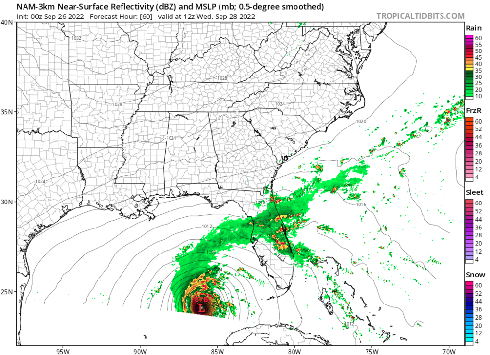
NAM landfalls south of Tampa Bay and the FV3 Hi-Res seems to be following the same track. Interesting to see the CAM start to lean towards a Tampa or points south landfall......very similar to some of the EURO op runs and the ensemble runs we seen the last few days
-
1
-
-
5 minutes ago, Superstorm93 said:
Hell of a time to have two recon planes in a rapidly intensifying hurricane

Ian is trying to evolve into a buzzsaw
-
Indeed we are seeing structure improvements and the pressure is steady now with minor pressure falls. Remember though, there is a lag between us seeing structure changes and the pressure actually tanking. By 5am we should see another significant pressure drop. It takes a few hours for the pressure to respond. It all does not happen at one time
-
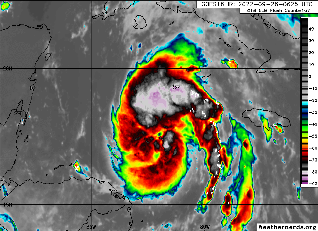
Very healthy CDO with deep convection wrapping around the center. Ian is off to the races now
-
32 minutes ago, csnavywx said:
That suddenly made me hungry...but I'm at work tonight and cant cook shrimp lol
-
...and we will just ignore the fact its virtualy stalled doing that so yeah, no upwelling what so ever lol
-
1
-
-

For humor purposes only.......want to see the potential "world record" RI process inbound? A 103mb drop in 12hrs.......brought to you by.......your neighborhood friendly 00z 3km NAM run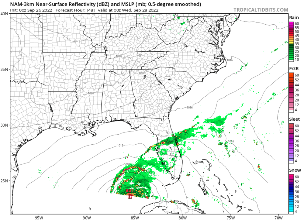
-
8
-


Hurricane Ian
in Tropical Headquarters
Posted
Point is...a major cane rolling into areas south of Tampa is devastating, a major cane stalling and creeping up the coast weakening is devastating, and landfall on Tampa is devastating. Maybe to be "politically correct" they arent equally devastating but none of those scenarios are better than the other...which was my point. Each scenario brings with it its own catastrophic situation. Whether that be prolonged wind, severe storm surge, catastrophic inland freshwater flooding, etc.