snowman33
-
Posts
72 -
Joined
-
Last visited
Content Type
Profiles
Blogs
Forums
American Weather
Media Demo
Store
Gallery
Everything posted by snowman33
-
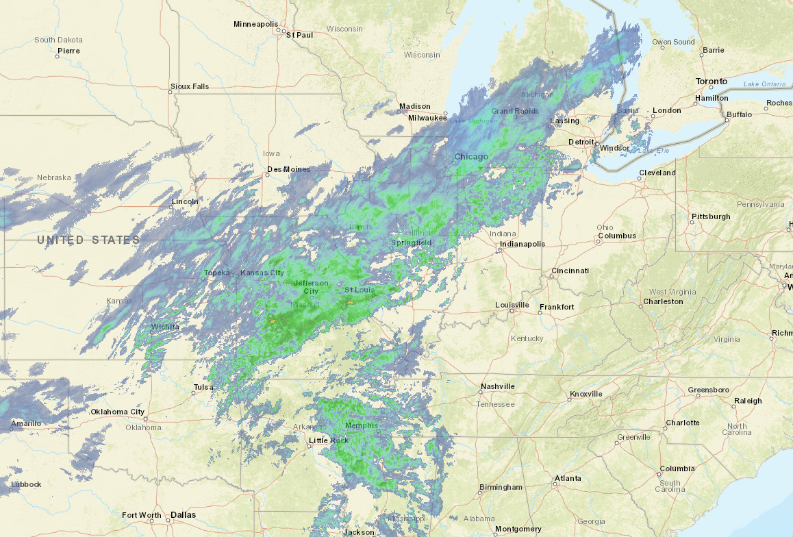
Not an expert by any means, just part of we the people... but I have lived in LOT my entire life and I think the office has done a terrible job with headlines this winter, well below their average. Lake, McHenry, and even Northern Cook should be under a Winter Storm Warning if you ask me. I bet we'll be seeing plenty of 6"+ reports out of this region Friday morning. Too much pessimism and not enough objectivity.
-
Don't worry, our early May dusting is coming.
-
Pre-Christmas (Dec 21-23rd) Winter Storm Part 2
snowman33 replied to Chicago Storm's topic in Lakes/Ohio Valley
Already have a dusting IMBY. HRRR isn't showing snow here until 2pm-3pm. -
Pre-Christmas (Dec 21-23rd) Winter Storm Part 2
snowman33 replied to Chicago Storm's topic in Lakes/Ohio Valley
Winter Storm Warning for 3-7". -
Pre-Christmas (Dec 21-23rd) Winter Storm Part 2
snowman33 replied to Chicago Storm's topic in Lakes/Ohio Valley
Ride GFS Kuchera! -
Pre-Christmas (Dec 21-23rd) Winter Storm Part 2
snowman33 replied to Chicago Storm's topic in Lakes/Ohio Valley
I see what the models are really trying to say... Merry Christmas ya filthy animal! -
One could say we're living in some dtrying times.
-
I lived through nearly three straight months of no precip last year. Wake me up when that happens again. Some oaks are struggling but hickories are fine this year. Fortunate we got good rains this past week.
-
Just got smoked... guess the stock market's CAPE isn't the only thing that popped today.
-
Just measured π" IMBY.
-
Kuchera or 10:1, pick the one that has the highest amounts. Gotta love it.
-
Wait for the FV3 before making that call.
-
Like bruh, we're the USA and the Europeans do a better job of predicting our own weather.
-
Thinking the Euro is gonna take the cake with this one, but we'll see.
-
5.6" at ORD? At this rate, GHD IV is gonna be a 33 and rain event.
-

-
26 inches in Champaign on the GFS, guessing that would smash the current record. I wonder if it will verify.
-
Ended up being a tick north in Chicago.
-
If my memory serves me correctly, the central axis of the heaviest snow was modelled to run through Valparaiso and South Bend on the globals. Then the hi-res models latched onto the north shift.
-
Yes lol.
-
Couldn't find the regular thread, but going off the GHD I weenie maps in there it looks like there was a bit of a north shift. For GHD II, the Euro was south around this time.
-
-
Going back to GHD II, it was the NAM that sniffed out the further north solution that ended up verifying. The Euro was south.
-
Both GHD events shifted north within the final 48 hours. Guess we'll see if third time's the charm.
-
Ride the Lake.