jwilson
-
Posts
1,294 -
Joined
-
Last visited
Content Type
Profiles
Blogs
Forums
American Weather
Media Demo
Store
Gallery
Everything posted by jwilson
-
I can't necessarily speak for the Philly area, but I know in the western part of the state we have had two Top-10 coldest Novembers in the last three years ('18 - 8th, and '19 - 10th). For the actual winter months, I'll have to go out further than Top-10. The most recent notable record is February 2015 (second coldest ever), followed by January 2003 (11th) and December 2010 (12th) . February of '07 and '14, December of '00 and '05, and January months of '03, '04, and '09 are all contemporary records. However, all of those months are way down the lists in the teens or even twenties. March is barely represented. 2014 is it on the "top" list, and it is way down there (19th). In the Top-18 for cold March, the most recent is March of 1984. Seems March hasn't been all that cold in a long time. Daily and yearly records are harder to find. 1994 is the most recent cold day. Seems the 80s were kinda cold, overall. If we consider certain elements to be cyclical, maybe things will shift back the other direction eventually. Or maybe climate change will prevent that and things are forever different and unpredictable. That analysis goes above my pay grade. TL;DR: One Top-10 in the last 20+ years: February of 2015 (for actual winter, anyway).
-
Western Pa / Pittsburgh area Winter Discussion ❄️☃️
jwilson replied to north pgh's topic in Upstate New York/Pennsylvania
The CMC quickly abandoned this look, waiting until the storm was off Maine's coast to wrap it up. The Euro shows a prototypical Miller A path from the Gulf, through Alabama/Georgia, and then setting it up off the Delmarva. The GFS has a very similar setup, a bit more convoluted, but there's no "snow side" or cold sector. It's all rain and shears off south of our area. Lack of cold air definitely is one concern. Seems this one might be an inland NE special. Really, I think 2010 was the last of this kind of storm. Pittsburgh is still long overdue for an 8"+ event. -
Western Pa / Pittsburgh area Winter Discussion ❄️☃️
jwilson replied to north pgh's topic in Upstate New York/Pennsylvania
I have friends in Mercer county that got well over a foot (perhaps upwards of 16-18"). That's crazy. Goes without saying but in areas with lake effect enhancement and/or elevation, this event pushed towards overperformance. -
Western Pa / Pittsburgh area Winter Discussion ❄️☃️
jwilson replied to north pgh's topic in Upstate New York/Pennsylvania
I measured a little over 3" a couple hours ago. The snow was extremely fine down here most of the day, but this last push may get us upwards of 5" or so. No complaints about this event on December 1st. Let's hope it is a sign of things to come the rest of the winter and not the exception. Heck, if we were to hit 5" officially, this storm alone would be more snow than we've gotten in 4 of the last 6 Decembers. -
Western Pa / Pittsburgh area Winter Discussion ❄️☃️
jwilson replied to north pgh's topic in Upstate New York/Pennsylvania
Looks like it should be snowing here, but it's just virga. Column looks mostly saturated so I guess the precip is still too light. -
Western Pa / Pittsburgh area Winter Discussion ❄️☃️
jwilson replied to north pgh's topic in Upstate New York/Pennsylvania
RGEM nails the AGH snow-hole, or inverted bullseye. Lock it in, boys! Also, cut the amounts by 25-50%.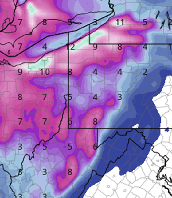
-
Western Pa / Pittsburgh area Winter Discussion ❄️☃️
jwilson replied to north pgh's topic in Upstate New York/Pennsylvania
Other than '17-'18 (13.3"), we've had a brutal run for December snow over the last six years. If this season unfolds as expected, any snow early is worthwhile, even needed. This won't be the blockbuster we'd all hope for, but perhaps we can muster a minor event out of it for the first accumulation. -
Western Pa / Pittsburgh area Winter Discussion ❄️☃️
jwilson replied to north pgh's topic in Upstate New York/Pennsylvania
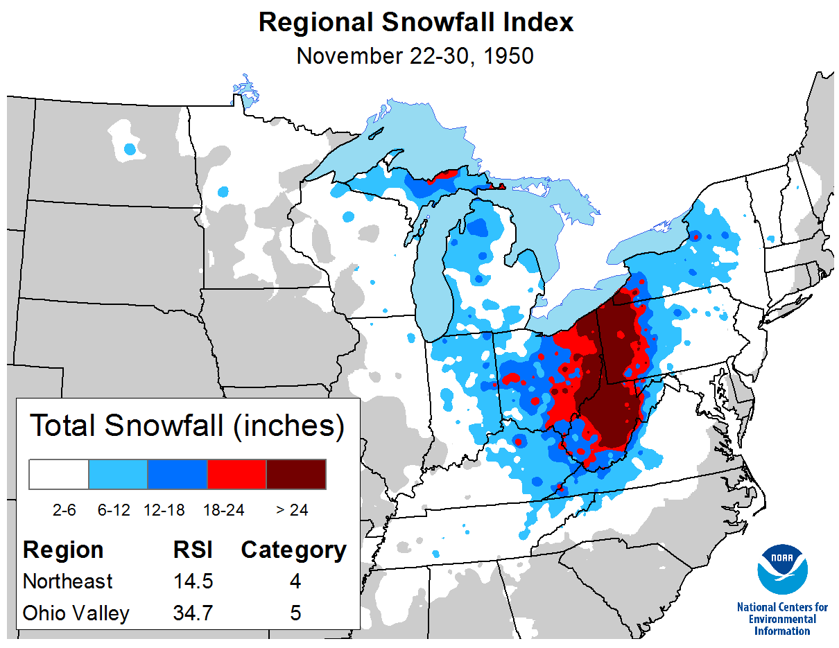
That snowfall map above looks quite familiar...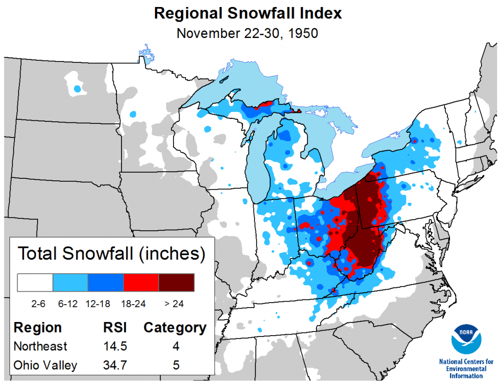
-
Pittsburgh/Western PA Banter & Complaint Thread
jwilson replied to blackngoldrules's topic in Upstate New York/Pennsylvania
For 2009, even I got screwed a tad on that one being in the Philly suburbs. Philly measured 23" and I got 12" - that entire winter was full of tight gradient snow storms. -
Pittsburgh/Western PA Banter & Complaint Thread
jwilson replied to blackngoldrules's topic in Upstate New York/Pennsylvania
If Wichita Falls, TX is getting a bigger snow than we've seen in years, you know there's something funky going on in weather town. -
Pittsburgh/Western PA Banter & Complaint Thread
jwilson replied to blackngoldrules's topic in Upstate New York/Pennsylvania
Long-range models can't decipher a good pattern to save their life, but as soon as a bad one appears: lock it in! You'd think I'd have learned by now that if the Euro shows a bad result, that's the outcome 90% of the time. (Also, if it shows a good result, that only works out 10% of the time). ... What's confirmation bias? -
Pittsburgh/Western PA Banter & Complaint Thread
jwilson replied to blackngoldrules's topic in Upstate New York/Pennsylvania
I don't know how others feel, but I prefer a snowy December to snow in March. Kind of disappointing that we've been stuck in this pattern lately where the snow doesn't really show up until January or even February. Still, Pittsburgh is way over due for an >8" storm. Because it isn't unprecedented, I'll consider this some relatively short-term trend. There have been snow lulls in history, extended ones usually followed up by a massive season of >70" total. As an illustration: Six of the last eight years we've had more snow in March than December. The long-term average still favors December, but they are close. -
Pittsburgh/Western PA Banter & Complaint Thread
jwilson replied to blackngoldrules's topic in Upstate New York/Pennsylvania
Yeah, I get why they were complaining (I think they were at historic levels of futility for snow), but everyone knew they'd play catch-up before long. Some people just need perspective, really. There's quite a few in the MA forum especially that would go insane living here. I can't imagine some of those guys making it 10 years without a double-digit event. -
Pittsburgh/Western PA Banter & Complaint Thread
jwilson replied to blackngoldrules's topic in Upstate New York/Pennsylvania
This just about sums it up for us. Welcome to the Screw Zone™ for all time. -
Pittsburgh/Western PA Banter & Complaint Thread
jwilson replied to blackngoldrules's topic in Upstate New York/Pennsylvania
The more these rain storms occur, the more I think this just isn't our winter. It was 0F last night and is close to 50F today. The atmosphere wants to rain here and that's it, as evidenced by our wettest year on record. This is a harsh pattern we've been set in since mid-2018 probably. If we're lucky, we'll dry out just in time for next winter. -
Pittsburgh/Western PA Banter & Complaint Thread
jwilson replied to blackngoldrules's topic in Upstate New York/Pennsylvania
We're well below normal so far (if we finish that way, it would make 3 of the last 4 winters). I agree that expectations for this winter were high. Things looked to align, but at this point, we're going to need a backloaded winter. The blocking that I think we require continues to be two weeks away in the long-term. Maybe by February it will actually coalesce. I'm hoping we don't revert to a bad pacific pattern or lose our moisture conveyor if the blocking comes together, but that's always possible. -
Pittsburgh/Western PA Banter & Complaint Thread
jwilson replied to blackngoldrules's topic in Upstate New York/Pennsylvania
Always a bridesmaid ... -
Snow and more
-
-
From the album: Winter
-
Pittsburgh/Western PA Banter & Complaint Thread
jwilson replied to blackngoldrules's topic in Upstate New York/Pennsylvania
I don't mind transient warmth in winter so much, say a day or two in between pattern flexes. I'm not a huge fan, however, of two to three weeks of the doldrums. Maybe we have once chance as the "new" pattern shuffles, but it doesn't look all that promising right now. -
Pittsburgh/Western PA Banter & Complaint Thread
jwilson replied to blackngoldrules's topic in Upstate New York/Pennsylvania
At least as I understand it, the TD can't count until you've become a runner, and you can't become a runner until you complete the process of the catch. If you're going to the ground as you catch the ball, you need to control the ball through the ground (no ground-assisted movement) or you can't complete the process of the catch, and in turn you can't become a runner. The rule is extremely convoluted, but it isn't the first time someone has been screwed by it. If the rule is called consistently, that's probably all you can ask for. My issue is whether they could truly overturn the call on the field. Replay evidence has to be 100%, zero doubt, conclusive. I think it's close, but that's not zero doubt. This is from an objective POV, by the way, as I'm not really a Steelers fan (sorry folks). -
Pittsburgh/Western PA Banter & Complaint Thread
jwilson replied to blackngoldrules's topic in Upstate New York/Pennsylvania
I need to move to Mammoth Lakes, CA. They're looking at another 3-6 feet of snow after getting something like 10 feet last week. Wouldn't have to kill myself model watching all the time when you seasonally get what we average locally over a decade or more. -
Pittsburgh/Western PA Banter & Complaint Thread
jwilson replied to blackngoldrules's topic in Upstate New York/Pennsylvania
So does that 4/5 day bullseye "jinx" continue? Didn't we have 2-3' a couple days ago, and now we are getting threatened by possible cloudy skies? Let's hope we can bounce back from this and have a better February. -
I don't post in this subforum much anymore because I moved years ago, but I still "lurk" frequently (split time with the Pittsburgh threads essentially). Though there is a decent chance this will be my home forum again within the next 6 months. This topic has come up on occasion, maybe once or twice a year. IMHO, I think generally it may make more sense to keep them apart. This forum is certainly plenty active when there is weather to discuss, I think, but the reality is this winter is dead for the time being. Other than the larger "macro" pattern, there's nothing really to talk about. And who knows if we see anything favorable this season. It just doesn't lend itself to great discussion. I'm sure other forums are more active because of more users. I don't know if that matters to others; I can say it doesn't matter to me. With NYC being as big as it is I can only imagine it swallowing up the Philly folks, perhaps making it difficult to separate the two. Eastern is a distant memory so I can't say I remember much about it and how we coexisted. I suppose if people really don't like it here they can attempt to generate more discussion or visit the other subforums, perhaps even the "new" Philly weather forums (though I haven't been there myself so I can't comment on it further). When speaking to merging, wouldn't merging with the Mid-Atlantic make just as much sense, if not more? I think Philly and Baltimore's long-term yearly snowfall averages are closer to each other than Philly and New York (though none are very far apart). Though D.C. is quite a drop-off from these three. I suppose an argument could be made either way. Perhaps we just merge them all and have individual threads for each city. I admit it is somewhat unfortunate the true "weather talent" (actual meteorologists) is spread so thin, having to traverse multiple subforums to access all the different opinions. Then again I understand much of this talent only offers discussion for their individual locales. Not sure if it would change their process if all the locations were merged. TL;DR: Didn't intend for this to be so long. I'll keep visiting regardless of what happens with the forum configuration. Prefer separate but okay with a merger whether it be NYC or MID-ATL & PHL.
-
Pittsburgh/Western PA Banter & Complaint Thread
jwilson replied to blackngoldrules's topic in Upstate New York/Pennsylvania
Yep, snow is over here. Looks like some heavier returns to move in, but at this point it is 38F and I don't think we'll cool down to return to snow. Dry slotted + rain. A double whammy (at least for some of us). It hasn't been the worst winter in history, but just about everything that could go wrong this year has to prevent any bigger storm in this area. I think I've had just enough disappointment for a year, ready to return to the golf course.