magpiemaniac
-
Posts
1,965 -
Joined
-
Last visited
Content Type
Profiles
Blogs
Forums
American Weather
Media Demo
Store
Gallery
Everything posted by magpiemaniac
-
NHC’s 11:00 AM cone shifted just a tad to the west compared to the previous update. It gives the Triangle area a chance for some rain. The 12z GFS did move west again, too, but I’ll remain skeptical at this point.
-
My downstairs HVAC is acting up which makes me immediately long for cooler fall temps. At least upstairs is fine. It’s always something.
-
Interestingly, the latest GFS and Euro have Elsa tracking along a more western path than the NHC guidance. They must know something I don’t, but they do it for a living and I’m a lowly member of a weather board.
-
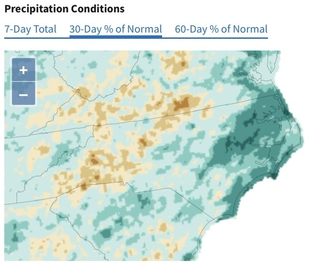
True. Other than the coastal plain, much of the upstate, foothills, and piedmont look dry. Same song; second verse. I’m thankful for Friday’s rain. I just wish we didn’t have to go weeks between such events.
-
My wife and daughter got the bright idea to run down to Myrtle Beach for a quick trip from this coming Wednesday to Friday. Not the best timing. I tried to tell her to check the forecast, but when she booked it, she said the NHC cone stopped in Georgia. (She’s a CPA and not much of a weather junkie.) I’m not sure what they’d run into driving down Wednesday afternoon and coming back Friday morning. It looks to be a fast moving system regardless. Some models showed a weakening system and clearing out for a decent Thursday at the beach. Other models showed some trouble. She can cancel, but needs to do so by late today to get a full refund.
-
For eleven years on this site, I’ve done nothing but complain about lackluster winters (and lately a relatively dry summer) only to be demoted to newbie? Thanks for nothing.
-
I watched that line approach your area on the radar. Crazy how it faded so quickly right at the New Bern city limits. I’ve had my share of that. Very frustrating.
-
Good to hear that you got something. My reverse psychology worked on this system. I kept poopooing it until it relented and gave me a lot of rain. LOL It finally started raining around 10:35 PM last night and ended around 8:00 AM with a half hour break around 2:30 AM. I’m at 2.84”. Best rain I’ve had in ages. Some stations over in NE Forsyth had 5” to 6”.
-
Congratulations. Glad someone is getting something. I’m at 0.00”, the latest HRRR run gives me a pleasant mist, and RAH is dropping their point forecast estimate like a rock. Tomorrow’s forecast goes from 90% (2.00”) to 60% (0.25”). Un-freakin’-real that I can’t get anything from this setup. Still sitting at 0.69” over the last three weeks.
-
High of 90.5 today. July picking up where June left off: bone dry. Absolutely giddy with excitement anticipating the 0.01” of rain I’m expecting by tomorrow evening.
-
More like Charlton Heston in Omega Man.
-
My wife has had bad headaches and neck stiffness ever since her second Pfizer shot and my brother-in-law developed heart inflammation. I’m waiting until Novavax releases their shot based on more traditional technology. I’m not really enthusiastic about being a guinea pig.
-
I get it, but my 2021 garden doesn’t remember 2019 monsoons.
-
These precipitation trends need to change by winter. If these were seasonal snow maps instead of rain, I’d go bonkers.
-
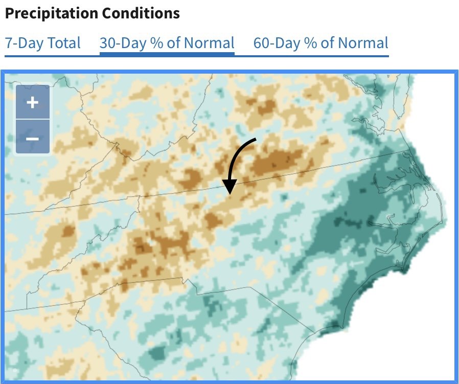
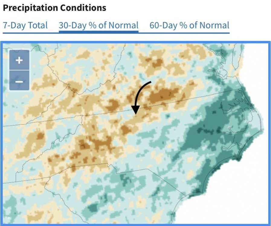
Misery loves company. My house is under the arrow. The brown dot matches the color of my grass. But you’re right. At least we’re not too worried about wildfires.
-
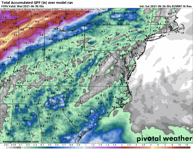
For weeks now, I’ve been used to storms coming from the southwest and dropping the most intense rain to my west and east. I’ve been in a dry corridor. I assumed that since this week’s front is approaching from the northwest there’s no way I could miss out on a good soaking rain. But the models are hinting otherwise. Most of the intense rain will form to my east after the front passes. I’ll end up with a 0.20” light shower of Friday while the Triangle will end up with 2.20”. You might think I’m joking, but just wait and see. The updated 30-day and 60-day precipitation map shows how dry the western areas of NC and SC have been compared to the east.
-
You’re right. It’s been quite. I went back and looked at logs and counted four thunderstorms (as determined by nearby lightning) here at the house since the beginning of the year.
-
RAH forecasts 1.3” of rain IMBY from Thursday afternoon to early Saturday morning. I’m definitely taking the under on that one. Last couple of Euro runs maintain the anti-precipitation shield over my house.
-
Lucky? You’ve been crushing it this month. I’m more likely to find tuna fish in a Subway sandwich than to get a decent rain here lately. I’ve not had a good soaking rain since June 11 and May 3 before that.
-
9.03” for June? That’s insane. IMBY, I have to add up daily totals all the back to April 10 to break the 9” mark.
-
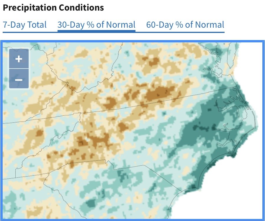
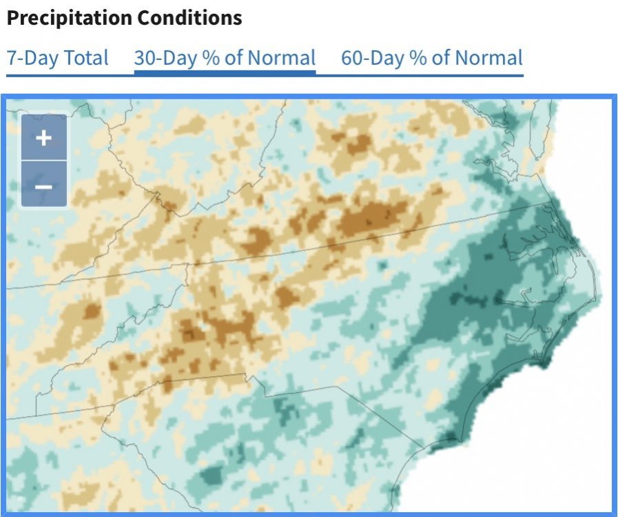
Every model shows the trend I’m talking about. I could see it at the micro level with storm after storm passing to my NW and SE, but then you confirm it on precipitation maps and see the models. It’s pretty frustrating. You’d think just one good system could bring the bulk of precipitation up I-85 at some point.
-
Possible high tomorrow in Portland, OR of 110. And I’m dying when it’s 93 here.
-
Areas in NC east of US Route 1 have been cashing in on rain for several weeks now. You can see that in the last month of rainfall. It looks like the models are going to maintain the trend, too. The I-85/Hwy 29 corridor might remain substantially drier than eastern NC and the mountains for the foreseeable future.
-
A beautiful 71 degree day. Looks to be the last unseasonably cooler day before some heats sets in.
-
I’m now at 4.20” for the month and have hit June’s historical average. Hooray! Believe it or not, 63% of this month’s rain fell within a 45 hour period on June 10 and 11.