

MJO812
-
Posts
76,099 -
Joined
-
Last visited
Content Type
Profiles
Blogs
Forums
American Weather
Media Demo
Store
Gallery
Posts posted by MJO812
-
-
5 minutes ago, snowman19 said:
Just yesterday morning, Joe Bastardi was hyping tomorrow into Tuesday as a 3-6 inch event with amounts up to 8 inches in NYC. Now, it’s a 1-2 inches of snow and sleet event even up here in Rockland, less than an inch for NYC
Models suck
-
 2
2
-
 1
1
-
-
2 minutes ago, qg_omega said:
Another week and more massive forecasting busts. This is due to the euro being really bad so far this year in the 2 to 5 day range. Heck it was even really bad last event at 12z the day the event was ongoing.
The euro has been really bad this season. Heck , it was even bad last season after the upgrade.
-
39 minutes ago, hudsonvalley21 said:
18z 12k.NAM bumped up totals a little vs.the12z run.
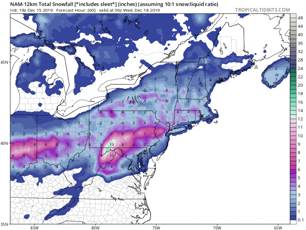
Nam was more aggressive with the overrunning. Have to watch that.
-
1
-
-
16 minutes ago, eduggs said:
The best wintry event between now and Christmas might end up being the arctic front on Wednesday.
Giving up on the storm already ?
-
11 minutes ago, snowman19 said:
Either the GFS/GEFS is going to score a rare coup or it’s going to bust horribly. The Euro/EPS, CMC/GEPS and UKMET are in agreement with a completely different solution with that low in the Great Lakes
It's a weak away. This is normal with big east coast storms. All we need is the pac to cooperate and the northern stream to dig.
Not impossible this far out
-
Rgem starts the city as snow and then changes to freezing rain
Cold run
-
1
-
-
34 minutes ago, bluewave said:
The GFS is currently on its own. The Euro, UKMET, and CMC have a low in the Great Lakes and a separate southern stream low.

Gfs has support from the gefs and we know how well the euro has been this season.
Euro came on board at 0z. I'm already seeing some media outlets already sounding the alarm lol
Pattern supports a storm . The pac has to cooperate.
-
12 minutes ago, bluewave said:
Need to lose that northern stream low over the GL so it doesn’t suppress the southern stream low.

Gfs and gefs look good
-
3 minutes ago, snowman19 said:
The NAM wants nothing to do with it. It’s now showing half an inch of snow total, even up here. https://www.tropicaltidbits.com/analysis/models/?model=namconus®ion=neus&pkg=asnowd&runtime=2019121512&fh=81
Its really far south and dry
-
1
-
-
2 minutes ago, NYCweatherNOW said:
How much does the euro 06z run have for us Ant... I heard it went way south!
Every model is getting drier for our area
-
1 minute ago, EastonSN+ said:
GFS has this as a more typical noreaster setup with the EURO a but wonkier.
Gefs is also on board big time
-
 1
1
-
-
Mid 30s and rain here for the city
Lovely
-
Just now, NJsnow89 said:
Nam is terrible for our area. Seems like a non event.
Its terrible for alot of areas unless you live to the west and especially the interior.
-
All rain for NYC on the Nam
The initial precip dries up as it heads east.
-
32 minutes ago, qg_omega said:
Looks like a very strong but in and out cold blast on Thursday?
That should set the table for the possible coastal storm this upcoming weekend
-
1
-
-
Gfs shows the big storm hitting us on the 22nd. Gefs has big hits.
-
Gefs has a big signal
-
1
-
-
Block is finally getting realized ? Maybe this will continue to track further south.
-
52 minutes ago, SnowGoose69 said:
Seems like it may have gotten a bit wetter too. Not necessarily here but the QPF signal seemed more Euro like and consistent this run
Freezing line is near the city throughout the Nam. Very icy.
-
49 minutes ago, CIK62 said:
I am watching this one for the educational value. A summary of possible snow totals: GFS 0"-1", Cobb Method is 0" , GEM is 2" (but has lost the 6" it had for the 22nd), EURO is 4", SREF is 1", UKMet is too secretive.
Prospects for any snow before year's end are dropping fast, so if you see some:
Catch a Falling Snowflake and Put It on Your Shovel-----Save It for the Next Snowless Day.
What?
-
Nam is even more south and colder
-
1
-
-
Nam is very cold and south
-
18z euro is once again further south and colder . Snow to rain for the coast with ice inland.
-
2 minutes ago, RedSky said:
Taking a nice trip to the Tughill it should bury those guys
Not the front end
Its further south
-
1
-


Minor to moderate winter event M-Tue Dec 16-17, 2019
in New York City Metro
Posted
People praise it way too much