

MJO812
-
Posts
70,758 -
Joined
-
Last visited
Content Type
Profiles
Blogs
Forums
American Weather
Media Demo
Store
Gallery
Posts posted by MJO812
-
-
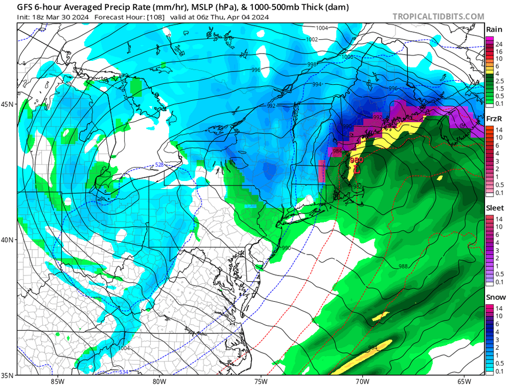
1 hour ago, bluewave said:
Models feeling the stronger Southeast ridge now so the 0z guidance came further north. Same northward correction we have been seeing all winter. The good news now is that it’s April and most people would want a warmer solution. So a continuation of the -NAO linking up with the Southeast ridge. Also a trend to deeper primary so the secondary isn’t nearly as strong as in earlier runs. Still a good soaker for the area but with a less intense low pressure.
New run

Old run

Nice ridge and blocking and still rain. Story of the past 2 winters.
-
3 minutes ago, WinterWolf said:
Dumb Post!
There have been alot of dumb posts lately. Allsnow and Bluewave says that the winters will not go back to a colder regime .
We don't know for sure what future winters will be and if this rubber band effect of warmer winters will continue.
-
 1
1
-
-
2 hours ago, ChangeofSeasonsWX said:
Yeah that north shift is probably the nail in the coffin for us here.
I'm still watching it here in NYC
-
 1
1
-
 1
1
-
-
Just now, dryslot said:
Pounded
-
 1
1
-
-
Gfs is a tick north
-
3 minutes ago, LibertyBell said:
thats going to be the end of the wet pattern
Yep
-
14 minutes ago, SnoSki14 said:
Looks like another 2" of rain on tap. Luckily it's spread out but it won't help.
Drier pattern hopefully coming after this wet stretch.
Next week is going to be wet
-
6 minutes ago, JetsPens87 said:
Reasonable
Once in a while I am
")
-
1
-
-
27 minutes ago, NEG NAO said:
the 12Z Euro shifted south with the snow accumulations in the metro

We need a weaker primary . I think we see all rain but it's very interesting to track.


-
1
-
-
12 minutes ago, JetsPens87 said:
Thanks. I don't crap on every threat. You know this.
It's amazing being ridiculed over 1 run of the CMC though by some here. I'll say that.
I have known you for years from other forums. When a storm is coming you will call it out.
-
2
-
-
10 minutes ago, SRRTA22 said:
Are you and snowman19 brothers?
They are both really conservative. Nothing wrong with that .
-
1
-
-
1 hour ago, NEG NAO said:
are you a real Meteorologist ? just asking....the reason I am asking is some well known METS use this model in forecasting and have never trashed it....
I wonder how far south this can go. We haven't had the NAO this negative in a while.
-
3
-
-
1 minute ago, George001 said:
If we can avoid attenuation in future runs this will become interesting even for areas closer to the coast.
I wonder how far south this storm can go. Impressive blocking.
-
46 minutes ago, JetsPens87 said:
Nice edit. You could've just asked why I trash it or what my reasoning was instead of being flat out insulting.
Look at the verification scores.
Ggem was once ahead of the gfs
-
1 hour ago, JetsPens87 said:
It is a legitimate garbage model
I mean you can say about any of the models. They all struggle.
-
2 minutes ago, MJO812 said:
Hi CMC

It came north so its not done coming north. Can't get lucky even with a negative NAO.
-
1
-
-
1 minute ago, NotSureWeather said:
CMC just parks it south of the cape for about a day. Sure.
It came north so its not done coming north. Can't get lucky even with a negative NAO.
-
Hi CMC
-
1
-
-
Big NAO block but the primary runs into it.
Can't win
-
-
Just now, Rtd208 said:
Even if we just get remnants of a tropical system that makes landfall to our south on the east coast or along the gulf coast that can still bring with it a whole slew of problems i.e. flooding, gusty winds etc.
Just like last September. There was flooding everywhere here.
-
Just now, Rtd208 said:
Yeah I was never tracking it for snow here. There is nothing like tracking a powerful coastal storm regardless of precipitation type. Always fun and exciting.
Rainy week ahead with rain starting Monday .
-
5 minutes ago, snowman19 said:
I’m worried about a dangerous Atlantic hurricane season coming up…record warm MDR already, ++AMO, rapidly developing (possibly strong) La Niña…bad, bad combination. I also think we see a very hot summer with a likely roided up SE ridge and given the extreme soil moisture we have in place, it’s probably going to be humid as hell too
The tropics are going to be very active. We should be on the lookout.
-
1
-
-
Just now, snowman19 said:
Yep, big warmup coming, multi-model ensemble agreement on that too. Would not surprise me at all to see widespread 70’s show up again
Agree
La nina coming in strong
-
1
-


April 2024
in New York City Metro
Posted
Nam is nice for the interior but likely too cold