

MJO812
-
Posts
70,825 -
Joined
-
Last visited
Content Type
Profiles
Blogs
Forums
American Weather
Media Demo
Store
Gallery
Posts posted by MJO812
-
-
2 minutes ago, LibertyBell said:
and of course snowman19. He was actually more gungho about February and he ended up being right about the one decent snowfall we did get, which was in February.
But snowman19 also forecasts no snow so is that a compliment?
-
1 minute ago, Brian5671 said:
The warning signs were there early this year
1. December warmth was much more widespread that many predicted
2. The pattern change delay into mid Jan. And even at that, you could see modeling returning the warmth very quickly-so it was only 8-9 days
3. The Feb pattern change was more of the same-a couple days of cold then back to the torch.
It was really over before it began this year and we were lucky to get the snow we got given a +5 Dec, +3 Jan +2 Feb and +5 March
Many forecasts were for a warm and snowless winter but there were hope from the weeklies which never materialized.
-
7 minutes ago, 40/70 Benchmark said:
Amazing how the trend that we do not want is what always prevails these past few seasons. Just unreal.
It's amazing even with the blocking. Usually we will have a weaker primary and a transfer further south but in these past winters nothing at all.
-
1 minute ago, LibertyBell said:
this is the south based block Chris has been talking about
Chris has received alot of weenies this past winter but he did a great job when everyone including myself was hard on him for being a warnista.
Same can be said for Allsnow. I think frustrations are setting in for many snow enthusiasts.
-
 3
3
-
-
Just now, JetsPens87 said:
It's not the worst model but I don't see it as a leading tool.
These days the only option is a blend of everything and especially favoring ensembles.
Good way to go
Every model has its days
-
Just now, JetsPens87 said:
The stronger blocking is only good when it doesn't link up with the WAR which has been forcing these systems further NW.
This one is allowed to escape up the Wrn edge of the block all the way to Lale Huron before transferring. That's never going to work out for us down here.
In the past 2 winters we have been screwed even with a negative nao because it has linked up with the WAR.
-
1
-
-
1 minute ago, JetsPens87 said:
A stronger WAR in recent history hasn't helped.
Bluewave is likely right about it being fueled by ever warmer SSTs
Bingo
The recent uptick in the water temps us making the SE ridge stronger. Usually with a strong block the primary will not go this far north and transfer further south .
-
2
-
-
21 minutes ago, JetsPens87 said:
Real Meteorologist Typhoon Tip also said he likes CMC in Neg NAO and AO episodes but in this instance an ensemble blend is best to use.
CMC is erroneously seeing something (but trending away from) the earlier transfer idea.
Walt Dragg also uses the CMC for his forecasting.
-
1
-
-
34 minutes ago, NEG NAO said:
it wasn't obvious but shows it has been showing this for several days now.........and a real Meteorologist Typhoon Tip likes how the model is handling this setup.....
The CMC kept showing the primary further south than the other models which showed a favorable transfer and a solution for our area while the other models were showing the opposite.
I thought we had a small chance with the strong blocking but nothing has been working out for us.
This is a NNE snowstorm
-
1
-
-
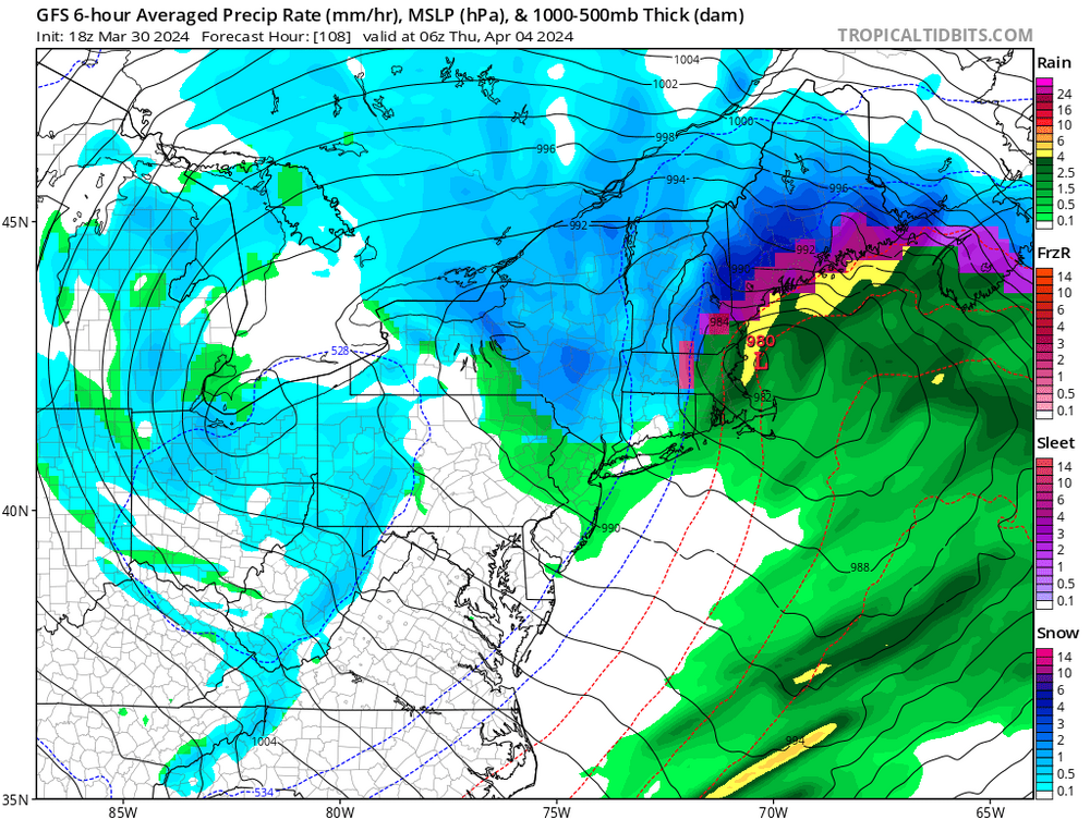
6 minutes ago, Rtd208 said:
No one here should have been tracking this storm for snow. It was always for heavy rain and strong winds. Not even sure how that will play out now.
The storm bombs out further north now on the models. Expect a dreary week.
-
1
-
-
7 minutes ago, JetsPens87 said:
Those clinging to the CMC...
This was obvious
-
2
-
-
1 minute ago, RUNNAWAYICEBERG said:
Cmc is coming north as well.
It is about time . It's over for anyone outside NNE.
-
6 minutes ago, CoastalWx said:
ICON looks warm with the primary over Lake Huron
Yep shifted north
-
Nam is nice for the interior but likely too cold
-
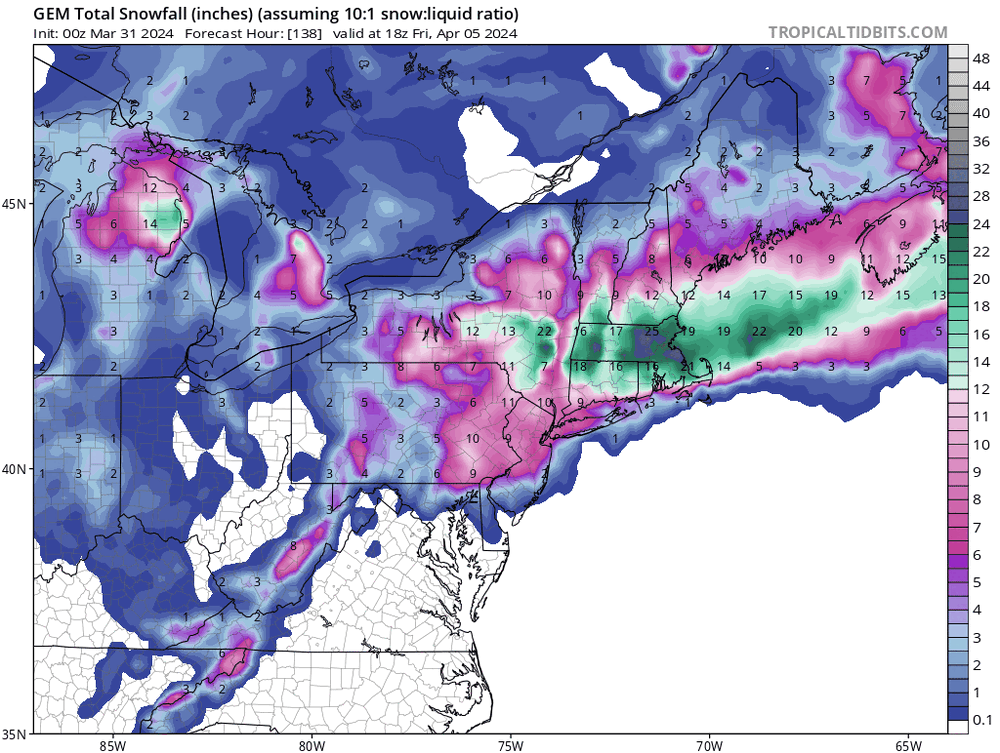
1 hour ago, bluewave said:
Models feeling the stronger Southeast ridge now so the 0z guidance came further north. Same northward correction we have been seeing all winter. The good news now is that it’s April and most people would want a warmer solution. So a continuation of the -NAO linking up with the Southeast ridge. Also a trend to deeper primary so the secondary isn’t nearly as strong as in earlier runs. Still a good soaker for the area but with a less intense low pressure.
New run

Old run

Nice ridge and blocking and still rain. Story of the past 2 winters.
-
3 minutes ago, WinterWolf said:
Dumb Post!
There have been alot of dumb posts lately. Allsnow and Bluewave says that the winters will not go back to a colder regime .
We don't know for sure what future winters will be and if this rubber band effect of warmer winters will continue.
-
 1
1
-
-
2 hours ago, ChangeofSeasonsWX said:
Yeah that north shift is probably the nail in the coffin for us here.
I'm still watching it here in NYC
-
 1
1
-
 1
1
-
-
Just now, dryslot said:
Pounded
-
1
-
-
Gfs is a tick north
-
3 minutes ago, LibertyBell said:
thats going to be the end of the wet pattern
Yep
-
14 minutes ago, SnoSki14 said:
Looks like another 2" of rain on tap. Luckily it's spread out but it won't help.
Drier pattern hopefully coming after this wet stretch.
Next week is going to be wet
-
6 minutes ago, JetsPens87 said:
Reasonable
Once in a while I am
")
-
1
-
-
27 minutes ago, NEG NAO said:
the 12Z Euro shifted south with the snow accumulations in the metro

We need a weaker primary . I think we see all rain but it's very interesting to track.


-
1
-
-
12 minutes ago, JetsPens87 said:
Thanks. I don't crap on every threat. You know this.
It's amazing being ridiculed over 1 run of the CMC though by some here. I'll say that.
I have known you for years from other forums. When a storm is coming you will call it out.
-
2
-


Significant Miller B Nor'easter watch, Apr 3rd-4th
in New England
Posted
Welcome to my climo