
OKwx_2001
-
Posts
69 -
Joined
-
Last visited
About OKwx_2001

- Birthday 02/22/2001
Recent Profile Visitors


-

Severe Weather event October 23rd-27th 2021
OKwx_2001 replied to weatherextreme's topic in Central/Western States
Just had a tornado warning here for the second time this month -
Severe Weather October 10th-12th 2021
OKwx_2001 replied to Sydney Claridge's topic in Central/Western States
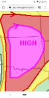
10 hatched tornado risk added now -
Severe Weather October 10th-12th 2021
OKwx_2001 replied to Sydney Claridge's topic in Central/Western States
Cell by Webbers Falls looks like it's about to produce. Has really tightened up the last few frames -
Severe Weather October 10th-12th 2021
OKwx_2001 replied to Sydney Claridge's topic in Central/Western States
Yeah 15 hatched definitely busted. 30 hatched hail and 45 hatched wind verified. So I'd say the moderate verified but definitely not for tornadoes. And I'm perfectly fine with that. Still could be some QLCS spin ups throughout the night -
Severe Weather October 10th-12th 2021
OKwx_2001 replied to Sydney Claridge's topic in Central/Western States
Tennis ball hail in the severe warned cell now. Will likely go tor warned pretty soon -
Severe Weather October 10th-12th 2021
OKwx_2001 replied to Sydney Claridge's topic in Central/Western States
That cell near Eldorado looks like it might be one to watch -
It will forever baffle me why people complain about short lived storms getting named
-
Eye drop supports 1000mb. That's a 9mb drop since the last eye drop 2 hours ago. Yeah let's hope that doesn't continue
-
2021 Atlantic Hurricane season
OKwx_2001 replied to StormchaserChuck!'s topic in Tropical Headquarters
It's one thing if someone says they think a season may be inactive and then provide reasoning for it, which I don't have a problem with at all and it's great to discuss different indicators for how active a season may or may not be. But continually trolling the forum with blatantly false statements is totally different and needs to be called out IMO -
2021 Atlantic Hurricane season
OKwx_2001 replied to StormchaserChuck!'s topic in Tropical Headquarters
You are the worst poster I've ever seen on a forum- 967 replies
-
- 14
-

-

-
2021 Atlantic Hurricane season
OKwx_2001 replied to StormchaserChuck!'s topic in Tropical Headquarters
That guy also said September 2017 would be dead and... It wasn't -
2021 Atlantic Hurricane season
OKwx_2001 replied to StormchaserChuck!'s topic in Tropical Headquarters
If the models were right all the time the 2020 season would have been dead and most of this season would be as well yet the complete opposite happened. Maybe you should stop filling up this thread with posts that obviously won't happen -
This one's gonna be around for awhile and will likely be the next major. Should be fun to watch as long as it recurves
-
2021 Atlantic Hurricane season
OKwx_2001 replied to StormchaserChuck!'s topic in Tropical Headquarters
Well August produced 6 named storms and nearly a 7th that will form in the next day or so. Also produced 2 majors in the gulf. This season is on pace to be another doozy... Btw didn't someone on here keep posting how August would only have 1 or 2 weak storms? Yeah their posts aged like milk -
BULLETIN Hurricane Ida Intermediate Advisory Number 9A NWS National Hurricane Center Miami FL AL092021 100 PM CDT Sat Aug 28 2021 ...IDA INTENSIFYING OVER THE GULF OF MEXICO... ...PREPARATIONS TO PROTECT LIFE AND PROPERTY SHOULD BE RUSHED TO COMPLETION TODAY IN THE WARNING AREA ALONG THE NORTHERN GULF COAST... SUMMARY OF 100 PM CDT...1800 UTC...INFORMATION ---------------------------------------------- LOCATION...25.5N 86.6W ABOUT 290 MI...470 KM SSE OF THE MOUTH OF THE MISSISSIPPI RIVER ABOUT 380 MI...610 KM SE OF HOUMA LOUISIANA MAXIMUM SUSTAINED WINDS...100 MPH...155 KM/H PRESENT MOVEMENT...NW OR 315 DEGREES AT 16 MPH...26 KM/H MINIMUM CENTRAL PRESSURE...976 MB...28.82 INCHES
