

Mount Joy Snowman
-
Posts
4,746 -
Joined
-
Last visited
Content Type
Profiles
Blogs
Forums
American Weather
Media Demo
Store
Gallery
Everything posted by Mount Joy Snowman
-

Central PA Spring 2025
Mount Joy Snowman replied to canderson's topic in Upstate New York/Pennsylvania
The HRRR paints a few inches of snow down into the furnace hills of northern Lancaster County and the higher terrain of northern Chester County. Highly doubtful but would be quite something. -
Central PA Spring 2025
Mount Joy Snowman replied to canderson's topic in Upstate New York/Pennsylvania
It will get here, slowly but surely. I think we're in for a good pounding from late evening through the overnight, from rain that is. -
Central PA Spring 2025
Mount Joy Snowman replied to canderson's topic in Upstate New York/Pennsylvania
Low of 39 with .08" of additional rainfall. Also forgot to mention that I got my first mow in on Wednesday. -
Central PA Spring 2025
Mount Joy Snowman replied to canderson's topic in Upstate New York/Pennsylvania
This is actually pretty damn cool. Thanks for digging that up and sharing. Incredible. -
Central PA Spring 2025
Mount Joy Snowman replied to canderson's topic in Upstate New York/Pennsylvania
Temp at 41 with .01" of rain. Gloomy days ahead. -
Central PA Spring 2025
Mount Joy Snowman replied to canderson's topic in Upstate New York/Pennsylvania
Low of 24 at my place. Brrrrrrr -
Central PA Spring 2025
Mount Joy Snowman replied to canderson's topic in Upstate New York/Pennsylvania
It’s obnoxiously obscene out there. Just walked to the train and didn’t feel much better than this morning ha. -
Central PA Spring 2025
Mount Joy Snowman replied to canderson's topic in Upstate New York/Pennsylvania
A tight race through the first quarter of the year! Remind me of your 2024 total again. I was at 40.45". -
Central PA Spring 2025
Mount Joy Snowman replied to canderson's topic in Upstate New York/Pennsylvania
Oh man, you just reminded me of how much dog damage I have to repair this year. We have two dogs in a fenced-in area and between the pissing and digging it's doing a number on my once-lush lawn. Dogs, I love 'em but man they're a lot sometimes, especially when you have toddlers that take priority. -
Central PA Spring 2025
Mount Joy Snowman replied to canderson's topic in Upstate New York/Pennsylvania
I'm at 2.31" for that same time period. Later this week is certainly looking juicier for our neck of the woods. If we get another 1-2"+ things are going to be downright soggy in my yard. Drought be damned. What is your YTD total? I'm at 7.52". -
Central PA Spring 2025
Mount Joy Snowman replied to canderson's topic in Upstate New York/Pennsylvania
In the 18 years I've been coming into Harrisburg, that may have been the most brutal April walk I've ever had. The winds were absolutely howling through a couple of the alleyways. Glad I broke out the winter jacket again. Also, I have now received measurable precip on six consecutive days and eight of the last nine. Carry on. -
Central PA Spring 2025
Mount Joy Snowman replied to canderson's topic in Upstate New York/Pennsylvania
32 when I left the house and .07” of additional rainfall. -
Central PA Spring 2025
Mount Joy Snowman replied to canderson's topic in Upstate New York/Pennsylvania
No AC here yet pal! I refuse to put it on for those brief one-off type bouts of heat. There was only one time it got a bit uncomfortable in the house and even then there was a potent cold front moving through that very night, so I wasn't going to run AC to then just turn right around and run heat less than 24 hours later. It's all a big game to me ha. I've become quite the magician at tweaking windows, shades, circulating fan, etc. to avoid having to run AC too early in the spring or heat too early in the fall. But I do love your tales of blasting AC in the winter haha. To each their own! -
Central PA Spring 2025
Mount Joy Snowman replied to canderson's topic in Upstate New York/Pennsylvania
Low of 37 and .32" of additional rainfall, bringing my total within the past week to 2.24". In honor of @Itstrainingtime being back, here is a snow pic from my buddy's cabin this morning. Happy Monday! -
Central PA Spring 2025
Mount Joy Snowman replied to canderson's topic in Upstate New York/Pennsylvania
Low of 48 with .41” of rainfall. Chilly days ahead. -
Central PA Spring 2025
Mount Joy Snowman replied to canderson's topic in Upstate New York/Pennsylvania
Low of 54 with .01” of rain. -
Central PA Spring 2025
Mount Joy Snowman replied to canderson's topic in Upstate New York/Pennsylvania
Circling back here, this ended up being one of my worst predictions ever haha, especially considering there were only four days left in the month at that point. Those last few days of March came in much colder than originally forecasted. Damn backdoor cold fronts and their overperforming tendencies ha. Ended up at 47.1 for the month, good for 11th all-time. -
Central PA Spring 2025
Mount Joy Snowman replied to canderson's topic in Upstate New York/Pennsylvania
Low of 59 and an absolute light show down here in the middle of the night that led to an additional .65" in the gauge. Kids slept through but the dogs weren't happy. Now up to 1.5" over the last few days. -
Central PA Spring 2025
Mount Joy Snowman replied to canderson's topic in Upstate New York/Pennsylvania
Low of 45 with .02" of additional rainfall. Time to get socked in the clouds for a few days. -
Central PA Spring 2025
Mount Joy Snowman replied to canderson's topic in Upstate New York/Pennsylvania
31 when I left the house. It seems like the heaviest totals over the next five days will stay just to our west. Still a beneficial period.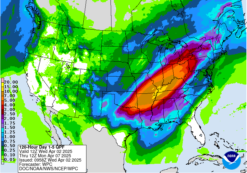
-
Central PA Spring 2025
Mount Joy Snowman replied to canderson's topic in Upstate New York/Pennsylvania
Low of 39 with .82” of much needed rain. Feels nice and brisk out there with everything greening up. -
Central PA Spring 2025
Mount Joy Snowman replied to canderson's topic in Upstate New York/Pennsylvania
A lot of lightning and thunder down this way tonight, to go along with a nice soaking rain. Looks like about 2/3 of an inch so far. Final total in the morning. -
Central PA Spring 2025
Mount Joy Snowman replied to canderson's topic in Upstate New York/Pennsylvania
Low of 61 with .01" of rainfall. Kind of a classic spring week on tap and then it looks like we could turn cold for a few days next week. -
Central PA Spring 2025
Mount Joy Snowman replied to canderson's topic in Upstate New York/Pennsylvania
Keep fighting Blizz! -
Central PA Spring 2025
Mount Joy Snowman replied to canderson's topic in Upstate New York/Pennsylvania
Low of 47 and .03” of rain. A nice warm weekend ahead. Should feel nice though with the mix of clouds and breezes.


