Mount Joy Snowman
-
Posts
4,952 -
Joined
-
Last visited
Content Type
Profiles
Blogs
Forums
American Weather
Media Demo
Store
Gallery
Everything posted by Mount Joy Snowman
-

Central PA Summer 2026 Discussion/Obs Thread
Mount Joy Snowman replied to Voyager's topic in Upstate New York/Pennsylvania
THIS. I don’t think enough people are familiar with that area. I won’t speak to any type of agenda but his station setup is probably about as good as it gets for a home station. I’ve at times compared his monthly departures to MDT’s monthly departures and they seem mostly consistent. -
Central PA Summer 2026 Discussion/Obs Thread
Mount Joy Snowman replied to Voyager's topic in Upstate New York/Pennsylvania
Amen. I'll be crossing over the Laurels tomorrow, as we head out to a friend's house in Westmoreland County for the 4th. Always fun watching the temp drop as you climb the big hill and come through the tunnel. -
Central PA Summer 2026 Discussion/Obs Thread
Mount Joy Snowman replied to Voyager's topic in Upstate New York/Pennsylvania
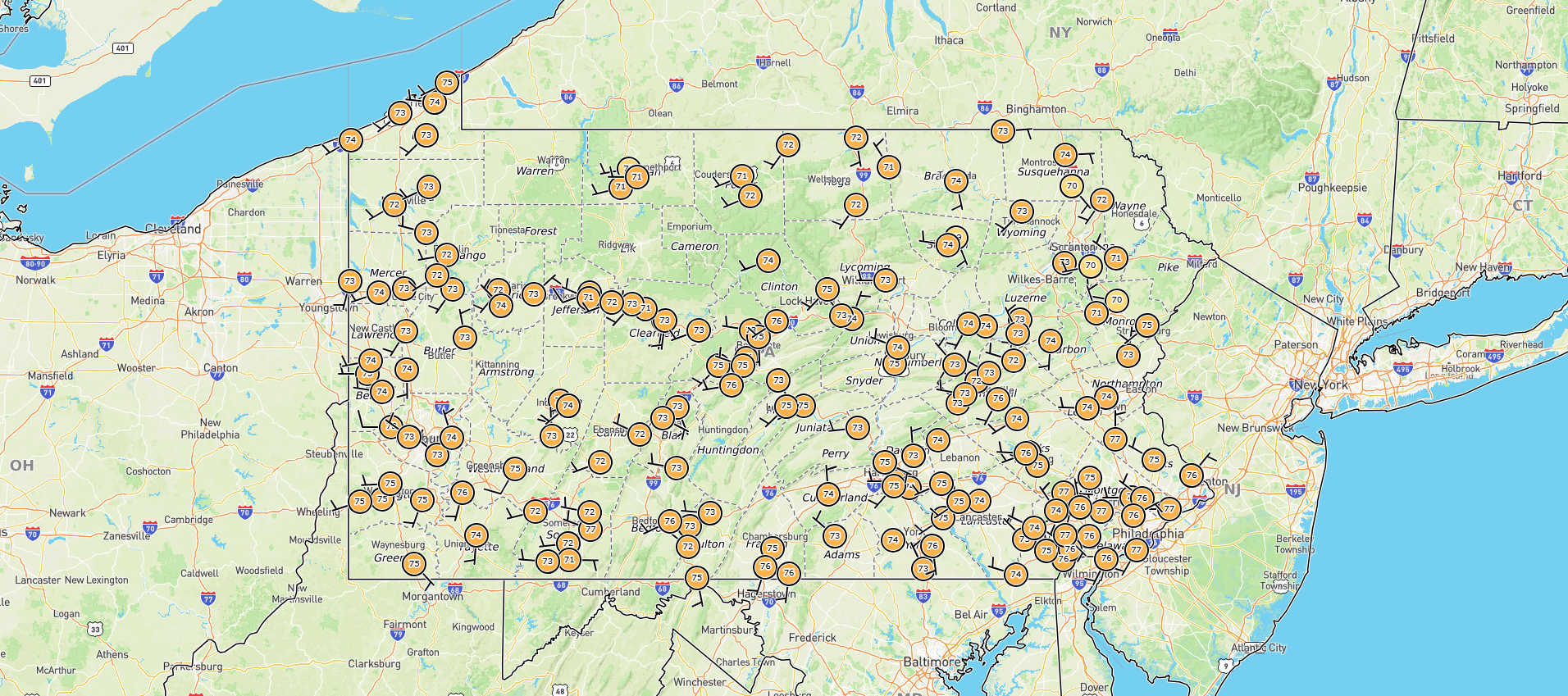
Low of 75. Let's see how high we can go. My forecast for tomorrow got knocked down a couple degrees to 101 but remains at 103 for today. While MDT fell a degree short of tying the record high for yesterday, it did set a new record max min of 77. We'll have to keep an eye on those max mins in the days ahead, although I think the upcoming days' records are more like 80. Don't get me started on home station dewpoints haha. Here is a map of current dews.....
-
Central PA Summer 2026 Discussion/Obs Thread
Mount Joy Snowman replied to Voyager's topic in Upstate New York/Pennsylvania
MDT ended the month with a mean temp of 73.8 and only .73" of rain, which is good for the 3rd driest June ever. I received 1.46" in June and have 16.41" for the year. I totaled 52.41" last year. -
Central PA Summer 2026 Discussion/Obs Thread
Mount Joy Snowman replied to Voyager's topic in Upstate New York/Pennsylvania
Low of 71. Let’s see how many Ben Franklins we can count the next few days. Stay cool everyone. -
Central PA Summer 2026 Discussion/Obs Thread
Mount Joy Snowman replied to Voyager's topic in Upstate New York/Pennsylvania
Welcome! Great story, I love all things Pine Creek related ha. -
Central PA Summer 2026 Discussion/Obs Thread
Mount Joy Snowman replied to Voyager's topic in Upstate New York/Pennsylvania
MDT daily record highs for July 1 thru July 4 -- 100, 104, 107, and 104. That is one tough set of records to breach. Tomorrow is obviously the most gettable but that's also the one day where my current forecast is under 100. We shall see but quite the historic heat wave on tap regardless. -
Central PA Summer 2026 Discussion/Obs Thread
Mount Joy Snowman replied to Voyager's topic in Upstate New York/Pennsylvania
Low of 66. Bring on the heat. -
Central PA Summer 2026 Discussion/Obs Thread
Mount Joy Snowman replied to Voyager's topic in Upstate New York/Pennsylvania
Low of 65. Looks like I'll finish June with 1.46" of rain, not as bad as I thought but still not good. I'm getting one last mow in today and then things turn crunchy for a while. -
Central PA Summer 2026 Discussion/Obs Thread
Mount Joy Snowman replied to Voyager's topic in Upstate New York/Pennsylvania
Low of 68 and a very underwhelming .06” of rainfall. As others have mentioned, things are going to get very dry after we bake out under this extreme heat this week. -
Central PA Summer 2026 Discussion/Obs Thread
Mount Joy Snowman replied to Voyager's topic in Upstate New York/Pennsylvania
Low of 67 with .06” of rain. Might have to start checking some records for next week. -
Central PA Summer 2026 Discussion/Obs Thread
Mount Joy Snowman replied to Voyager's topic in Upstate New York/Pennsylvania
Crystal Ball says we end the month with a mean temp of 73.9 degrees, about a degree and a half AN and good for 13th warmest all-time. Book it. -
Central PA Summer 2026 Discussion/Obs Thread
Mount Joy Snowman replied to Voyager's topic in Upstate New York/Pennsylvania
Low of 58. Hoping for some beneficial rains the next three days but not super confident we get a whole lot. Heat builds for 4th of July week. -
Central PA Summer 2026 Discussion/Obs Thread
Mount Joy Snowman replied to Voyager's topic in Upstate New York/Pennsylvania
Low of 57 and .31” of rainfall. Amazing day ahead. I love where we live. -
Central PA Summer 2026 Discussion/Obs Thread
Mount Joy Snowman replied to Voyager's topic in Upstate New York/Pennsylvania
Yep looks like a smidge over .3” in the gauge. I’ll take what I can get! Official reading in the morning. -
Central PA Summer 2026 Discussion/Obs Thread
Mount Joy Snowman replied to Voyager's topic in Upstate New York/Pennsylvania
I was thinking the same as I stare out the window here into the capital city. There was a sharp cutoff just southeast of Harrisburg, which was actually modeled very well by the Meso's this morning. I think I'm going to be up around a third of an inch back home. -
Central PA Summer 2026 Discussion/Obs Thread
Mount Joy Snowman replied to Voyager's topic in Upstate New York/Pennsylvania
Low of 69 and a disappointing .13” of total rainfall. Things just weren’t nearly stratiform enough yesterday and what did pop managed to miss me. Perhaps we get lucky today. Onward. -
Central PA Summer 2026 Discussion/Obs Thread
Mount Joy Snowman replied to Voyager's topic in Upstate New York/Pennsylvania
Low of 67 with .02” of additional rainfall. -
Central PA Summer 2026 Discussion/Obs Thread
Mount Joy Snowman replied to Voyager's topic in Upstate New York/Pennsylvania
Current temp of 71 is the low, to go along with .03" of rainfall. Hopefully we can squeeze a little more out of the day, although there doesn't seem to be much support for it. -
Central PA Summer 2026 Discussion/Obs Thread
Mount Joy Snowman replied to Voyager's topic in Upstate New York/Pennsylvania
Looks like 58 will be the low. Humidity creeping up today but nothing too bad. Looks like fairly minimal action tomorrow. Carry on. -
Central PA Summer 2026 Discussion/Obs Thread
Mount Joy Snowman replied to Voyager's topic in Upstate New York/Pennsylvania
Tried to get an early morning photo of MDT for you guys, through the dirty Amtrak window and all. Anyway, can confirm no jets affecting the weather station ha.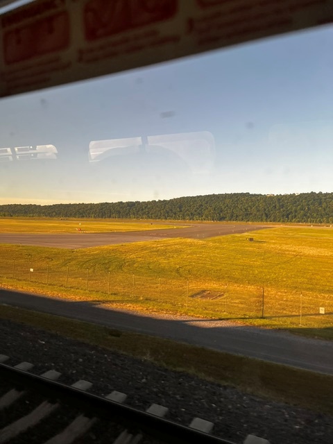
-
Central PA Summer 2026 Discussion/Obs Thread
Mount Joy Snowman replied to Voyager's topic in Upstate New York/Pennsylvania
A crisp 51 when I left the house. A+ day on tap. Onward. -
Central PA Summer 2026 Discussion/Obs Thread
Mount Joy Snowman replied to Voyager's topic in Upstate New York/Pennsylvania
Thanks JNS. Thought you may be the one to know haha. Well, that stinks. That site had been one of my main daily go-to visits for many years. A great one-stop shop. Ugh. -
Central PA Summer 2026 Discussion/Obs Thread
Mount Joy Snowman replied to Voyager's topic in Upstate New York/Pennsylvania
Does anybody know why the CTP page that provides a summary of max/min temps and precip twice a day for the ASOS sites hasn't updated since May 5th? If it is accessible somewhere else could someone please provide that? Below is a link to the page. Thanks. National Weather Service -
Central PA Summer 2026 Discussion/Obs Thread
Mount Joy Snowman replied to Voyager's topic in Upstate New York/Pennsylvania
Low of 61 with .35" of rain. Beautiful days ahead before things turn interesting for Thursday.