

Mount Joy Snowman
-
Posts
4,984 -
Joined
-
Last visited
Content Type
Profiles
Blogs
Forums
American Weather
Media Demo
Store
Gallery
Everything posted by Mount Joy Snowman
-

Central PA Summer 2026 Discussion/Obs Thread
Mount Joy Snowman replied to Voyager's topic in Upstate New York/Pennsylvania
Low of 70. Could be an interesting day. -
Central PA Summer 2026 Discussion/Obs Thread
Mount Joy Snowman replied to Voyager's topic in Upstate New York/Pennsylvania
Low of 56. Beautiful. -
Central PA Summer 2026 Discussion/Obs Thread
Mount Joy Snowman replied to Voyager's topic in Upstate New York/Pennsylvania
Just got off the river with the fam, absolutely perfect day. -
Central PA Summer 2026 Discussion/Obs Thread
Mount Joy Snowman replied to Voyager's topic in Upstate New York/Pennsylvania
Sorry to hear. Nothing remotely approaching severe anywhere down this way. Total rainfall of .19” with a low of 67. Outside of Tuesday, seems like a beautiful week ahead. -
Central PA Summer 2026 Discussion/Obs Thread
Mount Joy Snowman replied to Voyager's topic in Upstate New York/Pennsylvania
Hang in there. For many cycles now the HRRR has been advertising a very quick pullout of the smoke this afternoon. Already getting much better down this way. -
Central PA Summer 2026 Discussion/Obs Thread
Mount Joy Snowman replied to Voyager's topic in Upstate New York/Pennsylvania
It was a nice little lightning-fueled cell that dropped a quick .15”. A precursor for later? No wind though. Air is clearing up already. -
Central PA Summer 2026 Discussion/Obs Thread
Mount Joy Snowman replied to Voyager's topic in Upstate New York/Pennsylvania
Low of 68. Not entirely sure what to expect today as there’s quite a difference with the models in terms of timing/location/intensity. Just hoping no one suffers any damage. At least we get the smoke out of here this afternoon. -
Central PA Summer 2026 Discussion/Obs Thread
Mount Joy Snowman replied to Voyager's topic in Upstate New York/Pennsylvania
Low of 67 with thick smoke, which thankfully looks to clear out pretty quickly tomorrow afternoon. Hopefully we get some nice storms tomorrow and then Sunday looks beautiful. Harrisburg tied its max min record of 77 yesterday. National high of 121 at Stovepipe Wells, CA and low of 36 at Mt. Washington, NH. Carry on. -
Central PA Summer 2026 Discussion/Obs Thread
Mount Joy Snowman replied to Voyager's topic in Upstate New York/Pennsylvania
Low of 74 as the smoke starts to roll in. The heaviest of it appears to be tonight through tomorrow morning. May be pretty rough on Saturday as well, although I imagine the rain will help with that. LNS and THV topped out at only 93 and 94 yesterday. -
Central PA Summer 2026 Discussion/Obs Thread
Mount Joy Snowman replied to Voyager's topic in Upstate New York/Pennsylvania
Not sure why the image didn't post. Let's try this again.....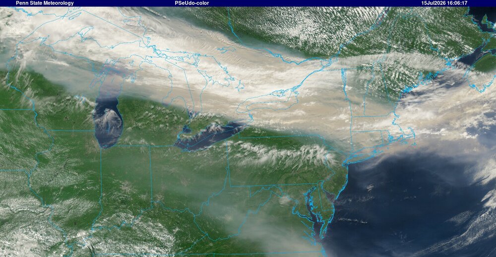
-
Central PA Summer 2026 Discussion/Obs Thread
Mount Joy Snowman replied to Voyager's topic in Upstate New York/Pennsylvania
That is some kind of smoke plume getting ready to drop down our way. New York blanketed. http://www.meteo.psu.edu/ewall/PSUGOES_NE/IMGv_0.jpg -
Central PA Summer 2026 Discussion/Obs Thread
Mount Joy Snowman replied to Voyager's topic in Upstate New York/Pennsylvania
Low of 71. A nasty couple of mid summer days ahead with high heat and smoke haze. Onward. -
Central PA Summer 2026 Discussion/Obs Thread
Mount Joy Snowman replied to Voyager's topic in Upstate New York/Pennsylvania
Tomorrow's fairly weak daily high record of 99 may be beatable, although smoke may knock off a couple degrees. -
Central PA Summer 2026 Discussion/Obs Thread
Mount Joy Snowman replied to Voyager's topic in Upstate New York/Pennsylvania
67 when I left the house. Got a mow in yesterday before the heat hits, first one in like two weeks. -
Central PA Summer 2026 Discussion/Obs Thread
Mount Joy Snowman replied to Voyager's topic in Upstate New York/Pennsylvania
Low of 62 here as well. -
Central PA Summer 2026 Discussion/Obs Thread
Mount Joy Snowman replied to Voyager's topic in Upstate New York/Pennsylvania
Low of 66 and .46” of rain. -
Central PA Summer 2026 Discussion/Obs Thread
Mount Joy Snowman replied to Voyager's topic in Upstate New York/Pennsylvania
A nice classic gusty summertime storm just went through here and dropped close to a half inch. No lightning though. -
Central PA Summer 2026 Discussion/Obs Thread
Mount Joy Snowman replied to Voyager's topic in Upstate New York/Pennsylvania
Low of 67 with .02” of rain. Onward. -
Central PA Summer 2026 Discussion/Obs Thread
Mount Joy Snowman replied to Voyager's topic in Upstate New York/Pennsylvania
Low of 69 with 1.31” of rain. I’ll finally have to mow again soon. Heading out on the river this morning. Happy Friday. -
Central PA Summer 2026 Discussion/Obs Thread
Mount Joy Snowman replied to Voyager's topic in Upstate New York/Pennsylvania
Incredible wind and rain here right now, wow! -
Central PA Summer 2026 Discussion/Obs Thread
Mount Joy Snowman replied to Voyager's topic in Upstate New York/Pennsylvania
That narrow band through northern York/Lanc Counties the last couple hours has really been something to behold, as it drifts ever so slowly. It's finally drooping down to my neck of the woods and seems imminent to start pouring as the thunder rolls. Gonna be some big totals, I reckon. -
Central PA Summer 2026 Discussion/Obs Thread
Mount Joy Snowman replied to Voyager's topic in Upstate New York/Pennsylvania
Low of 71 with a rounded-up .01” of rain from a brief early morning mini shower. Late this afternoon could get very interesting around here. -
Central PA Summer 2026 Discussion/Obs Thread
Mount Joy Snowman replied to Voyager's topic in Upstate New York/Pennsylvania
A refreshing low of 63. Time to catch the choo choo. -
Central PA Summer 2026 Discussion/Obs Thread
Mount Joy Snowman replied to Voyager's topic in Upstate New York/Pennsylvania
Low of 67 with .01” of rain from the very light drizzle occurring throughout the day. Looks like pretty standard mid-summer type weather ahead. -
Central PA Summer 2026 Discussion/Obs Thread
Mount Joy Snowman replied to Voyager's topic in Upstate New York/Pennsylvania
Low of 69 to go with a whopping 3.43” of rain. You know what though, my yard isn’t soggy at all, not even the normally swampy parts. We really needed that. Also, after the initial deluge we had an extended period of more moderate type rates so it wasn’t all runoff. Minimal wind damage here but have some buddies in the Manheim Township area that were hit hard again, with trampolines and patio furniture and the like strewn about.


