

CG2
-
Posts
85 -
Joined
-
Last visited
Content Type
Profiles
Blogs
Forums
American Weather
Media Demo
Store
Gallery
Everything posted by CG2
-
And what is crazy... the 18z NAM is really icy in NE TN. Up to .65" of ice accumulation for all of the TRI. Not sure folks are even aware of the threat here..........
-
18z RGEM is in....
-
Been awesome having Mississippi posters on the forum. Really glad to have you all back posting.
-
Cause who doesn't love a good NAM run where the ice isn't subtracted....
-

February/March 2021 - Frigid or Flop? Pattern/Longterm Forecast Thread.
CG2 replied to John1122's topic in Tennessee Valley
https://www.cpc.ncep.noaa.gov/products/precip/CWlink/MJO/CLIVAR/clivar_wh.shtml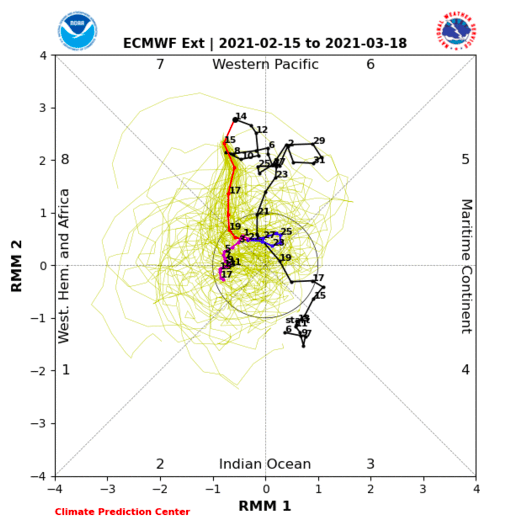
-
February/March 2021 - Frigid or Flop? Pattern/Longterm Forecast Thread.
CG2 replied to John1122's topic in Tennessee Valley
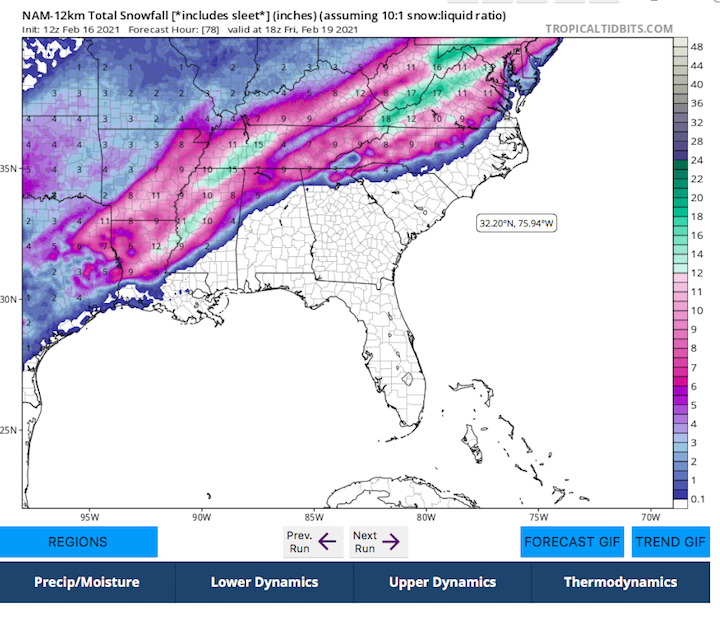
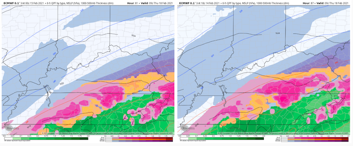
The 18z GEFS compared to the 0z GEFs for the same time frame and ending Saturday. E TN amounts are all Weds/Thurs on this. 18z EPS(which is an off-run so beware) has increased totals 1-2" as well compared to this time yesterday. Again, this is NOT a forecast but just discussion and trying to hone-in on what seems probable. For those new here, please understand we are just sorting through model runs right now. 18z on left and 0z on right...both from 2.15.21. The trend is for bigger totals...we will see if that holds.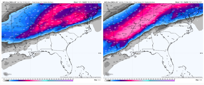
-
February/March 2021 - Frigid or Flop? Pattern/Longterm Forecast Thread.
CG2 replied to John1122's topic in Tennessee Valley
Now for west and middle folks...there is more after this. Basically a low spins up the Piedmont. Verbatim, I am not sure NE TN would even change over. This is how these overrunning systems normally operate. One system pushes the boundary just a step further. Does it happen? NO IDEA!!!! LOL. Just sharing maps...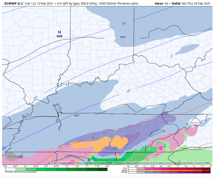
-
February/March 2021 - Frigid or Flop? Pattern/Longterm Forecast Thread.
CG2 replied to John1122's topic in Tennessee Valley
This is one of these systems where a big slug of precip busts out in front of the main low which is why the WAA is more significant. This is a fairly strong little system. -
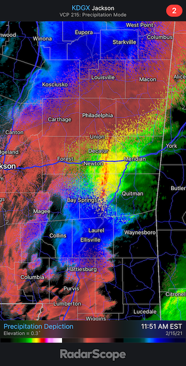
This is Mississippi. That is just nuts.
-
February/March 2021 - Frigid or Flop? Pattern/Longterm Forecast Thread.
CG2 replied to John1122's topic in Tennessee Valley
12z CMC....Still keeping an eye on overnight Wednesday and Thursday AM. We will see if the warm nose can scour this out, but a major CAD signal for North Carolina, and with a different set of dynamics, cold which is having trouble getting out of the way at TRI. Sometimes modeling does not do well with identifying where the cold is that is just stubborn in leaving.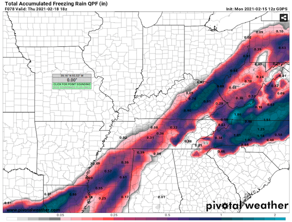
-
February/March 2021 - Frigid or Flop? Pattern/Longterm Forecast Thread.
CG2 replied to John1122's topic in Tennessee Valley
The 12z GFS....through Thursday AM. Can see a pretty good thump from TYS to SW VA.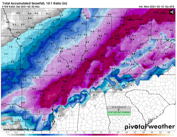
-
Time for people in west TN to wake-up and give us some updates!!!
-
February/March 2021 - Frigid or Flop? Pattern/Longterm Forecast Thread.
CG2 replied to John1122's topic in Tennessee Valley
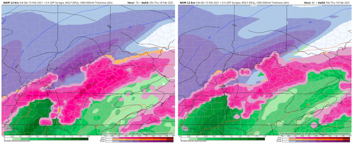
Yep, so pretty much all modeling is on board now with varying levels of WAA frozen precip for the eastern valley Weds Night/early Thursday. Here is the side-by-side comparison of the 6z and 0z. One can see the trend. Again, something we will watch for the eastern valley....nothing set in stone. Just trend watching. Of note, there is light snow just one frame prior to this for NE TN.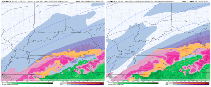
-
February/March 2021 - Frigid or Flop? Pattern/Longterm Forecast Thread.
CG2 replied to John1122's topic in Tennessee Valley
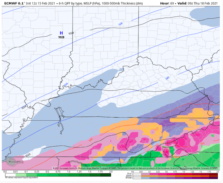
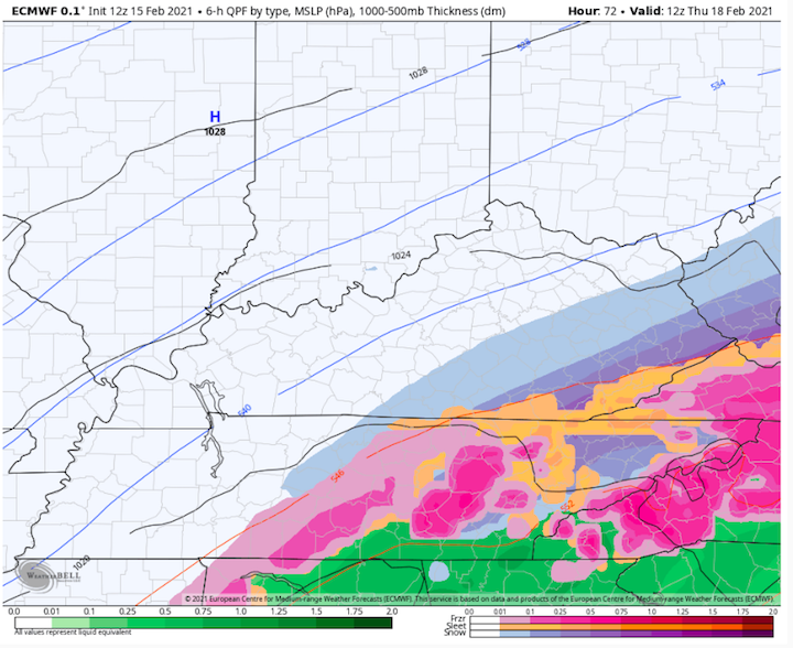
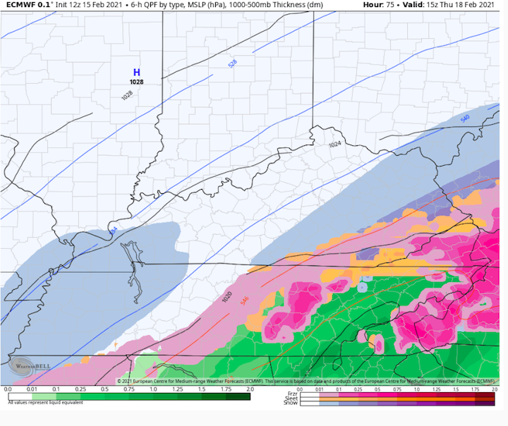
As Holston noted, this is WAA scenario. Again, this will depend on time of day and how far the cold bleeds over from the Plateau. It is worth noting, because it is showing up on several models. WAA means warm air advection for those who are new to this. Basically, cold air gets trapped at the surface as warm air and precip move in at higher altitudes. Usually, we see snow to sleet to freezing rain to just rain. Going to keep an eye on this as some modeling, specifically the GFS and RGEM which have done well this year, are showing a longer duration WAA event than what we are used to. Guess is the cold air trends north a bit...but the last two runs have trended south which is why I am mentioning it. Here is the 6z NAM at range and is likely way overly amped. Here is the 0z CMC. Again, just watching trends. New is on the left, and old on the right.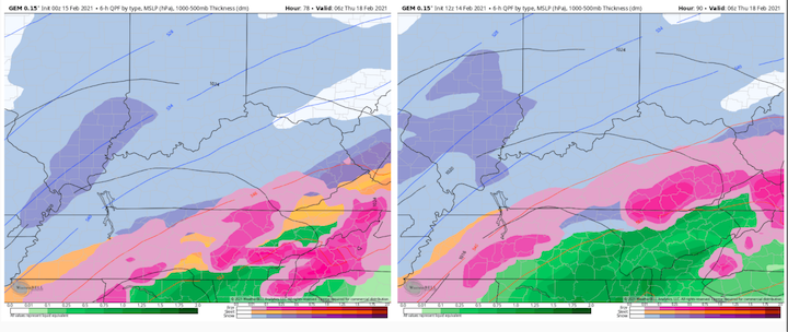
-
February/March 2021 - Frigid or Flop? Pattern/Longterm Forecast Thread.
CG2 replied to John1122's topic in Tennessee Valley
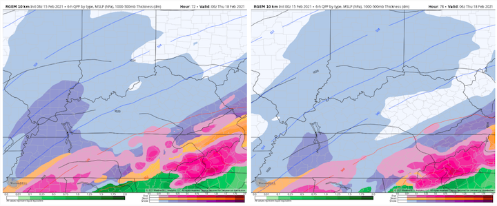
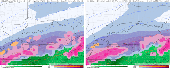
Here are the latest runs of the GFS, RGEM, Euro, and para-GFS at onset and compared to their previous runs for comparison purposes. New run is on the left.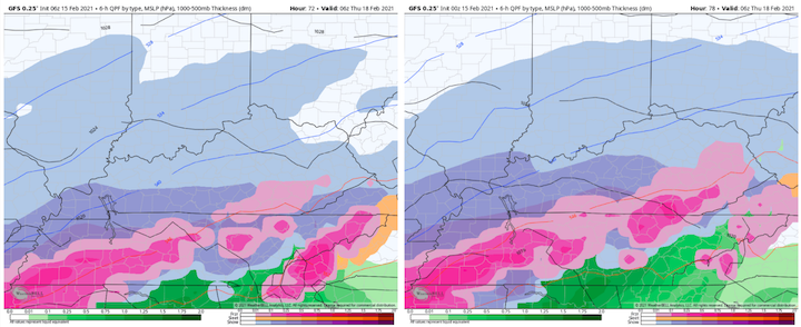
-
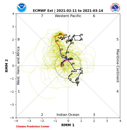
For posterity - a wider view. MJO phase 7(almost 6), long standing -NAO(but quickly rising), very cold NA temps which have plunged into the central US, and cold is banked up against the Plateau. What a weather map from the front range of the Rockies to the Apps and/or Plateau!!!!
-
February/March 2021 - Frigid or Flop? Pattern/Longterm Forecast Thread.
CG2 replied to John1122's topic in Tennessee Valley
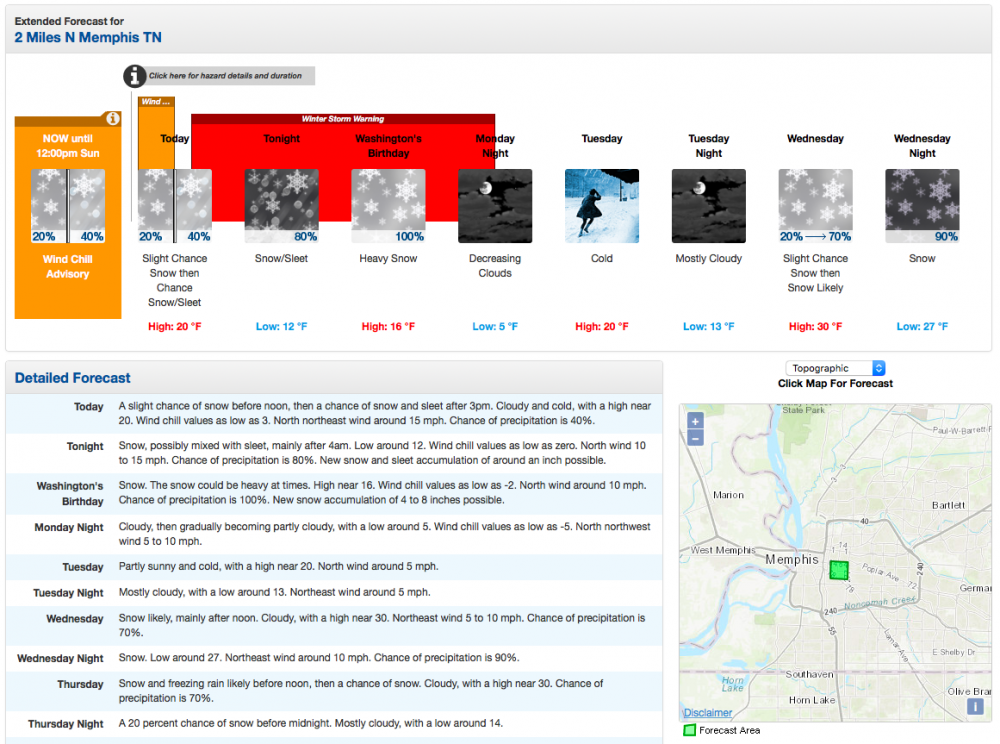
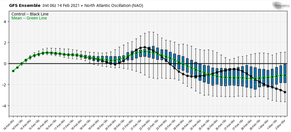
Long Range Ideas and Short/Mid-Range Commentary: Here are the 0z EPS NAO and the 6z GEFS NAO forecasts from earlier today. All three current global ensembles are depicting the NAO to re-fire around the 25th. This does signal an at least temporary eastern ridge after this week(as the pattern waits for a -NAO reload), and then the potential exists for a return to a colder pattern towards the end of February and/or the beginning of March(likeliest is early March). This has been the pattern this winter. We see cold, we get a few weeks break, and then it returns. Would not surprise me if the cold returns one last time relative to March norms. I hate to quote Cosgrove without his permission, so I will simply state that he thinks the relaxation of the pattern during late February is simply the pattern recharging for one more cold shot similar to what we have now but maybe excluding the Deep South. I would note that when the NAO changes phases to negative (or leaves negative) that is when we might see another round of storms. I could be wrong, but would be very surprised if winter is over. I think we see a relaxation coming up very similar to what we saw in January(just shorter) and then maybe one last bout of winter. I think the -NAO has more than proven its value this winter as western(and hopefully middle as well!) subforum areas of the TN Valley Region are possibly about to experience one of the great winter patterns of recent memory for this subforum and for their local. If the NWS verifies for Memphis this week, this pattern could well be the best winter pattern for them during the past two decades. Their temps are not forecast to rise above freezing until next Saturday! They are modeled to have two winter storms. Just because the NAO does not deliver IMBY, does not mean it is not a signifiant pattern driver for winter weather for this region - even on its own. It is also worth noting that this maturing of the trough occurred right at the end of the current negative phase of the NAO. That is worth remembering if the NAO goes negative once again (if LR modeling is correct) later this month. As a final caveat, the NAO is a tricky animal to forecast...so keep that in mind when looking at LR forecasts showing it re-firing. I think it likely, but not a certainty. I am also adding the EMON from the 11th. The Euro MJO looks nearly identical today. Notice the dive back to cooler phases after the jaunt towards six. For posterity(and for future reference regarding the NAO), I am attaching the Memphis forecast for the week. They are simultaneously under a wind child advisory and winter storm warning with yet another winter storm modeled for mid-week. Also, it is worth noting that the MJO is at mid-amplitude phase 7(nearly 6). The NAO has overcome warm phases of the MJO as well. Lastly, I think this forum has done a great job with pattern recognition this winter. That doesn't mean we nail every storm, but I think folks have done a great job of weighing the possibilities "for" and "against" winter weather. Hopefully, after the warm up set to unfold after 6-7 days, we see one more bout of winter. Good luck(meaning lots of snow and not as much ice) to those in middle and western forum areas this week!!! Addendum note: Some modeling is also hinting that the EPO may go briefly negative right as the NAO block potentially reforms later this month and early March.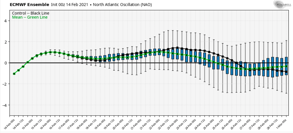
-
February/March 2021 - Frigid or Flop? Pattern/Longterm Forecast Thread.
CG2 replied to John1122's topic in Tennessee Valley
18z GFS SLP location is east of the Apps. Not sure how much more east it can actually trend. At some point, it trends back west - I think. However, the ensemble does hint that a mixed bag IMBY is not out of the possibility on Tuesday. Not gumming up the middle/west TN storm thread with this though. LOL.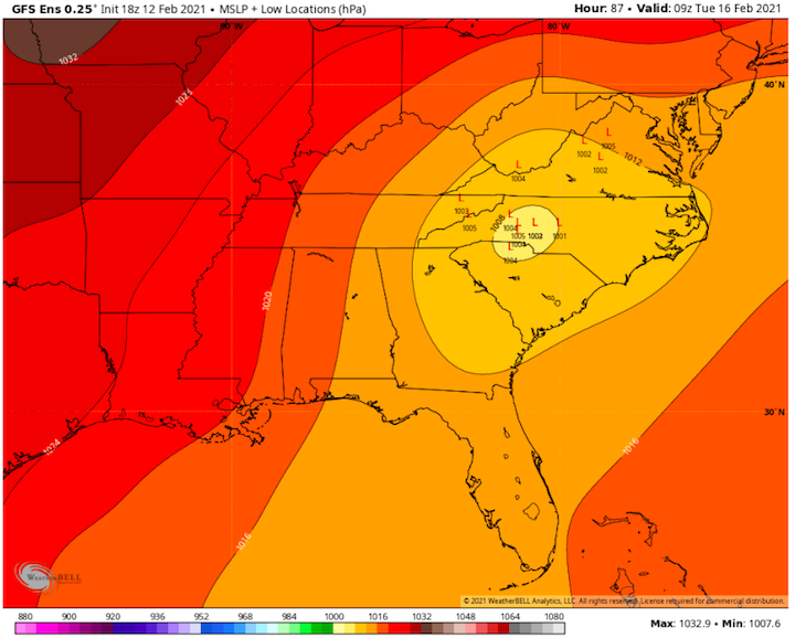
-
February/March 2021 - Frigid or Flop? Pattern/Longterm Forecast Thread.
CG2 replied to John1122's topic in Tennessee Valley
I do it all the time! LOL. Just whichever threat is at the top! LOL. Great to have you posting! -
February/March 2021 - Frigid or Flop? Pattern/Longterm Forecast Thread.
CG2 replied to John1122's topic in Tennessee Valley
I would place that in the storm thread. Great find. -
February/March 2021 - Frigid or Flop? Pattern/Longterm Forecast Thread.
CG2 replied to John1122's topic in Tennessee Valley
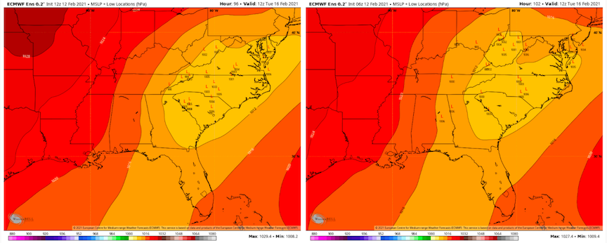
Not calling for a storm IMBY yet, but I think the jury is still out on how this SLP system develops on Tuesday. Here are the comparison runs for the 12z EPS 90 and 96 time frames compared to 6z. Notice the shift south and east. New is on the left. There has been a trend towards moving this area of weak slp to our SE and reducing or eliminating energy coming west of the Apps. May or may not hold, but that is the trend on some modeling. Notice that at 6z many SLPs went through E TN and into WVA. At 12z, many went from central Georgia and into the Carolina Piedmont.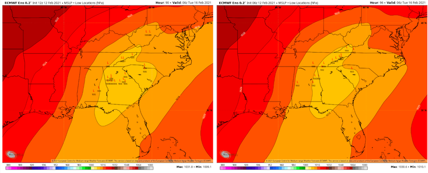
-
February/March 2021 - Frigid or Flop? Pattern/Longterm Forecast Thread.
CG2 replied to John1122's topic in Tennessee Valley
This is a little earlier in the run....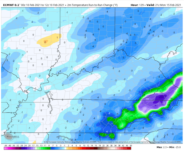
-
February/March 2021 - Frigid or Flop? Pattern/Longterm Forecast Thread.
CG2 replied to John1122's topic in Tennessee Valley
Yet again, the 6z GEFS is depicting a strong snow mean for NE TN and SW VA...and really much of the state given the time of year. Bet folks in NW MS haven't seen a Feb snow mean like that in a long time! That is the full run....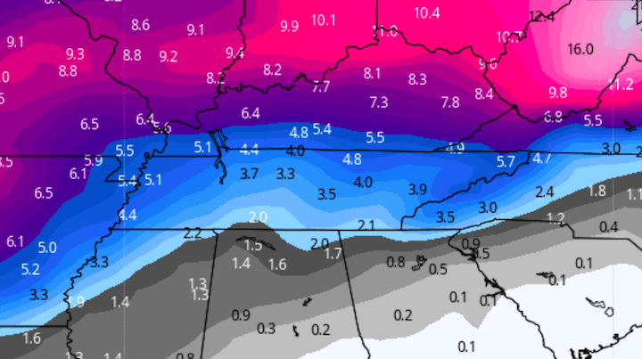
-
February/March 2021 - Frigid or Flop? Pattern/Longterm Forecast Thread.
CG2 replied to John1122's topic in Tennessee Valley
The change in modeling is directly correlated to modeling seemingly making an error in taking the MJO into 8. Now, IMO we will see the MJO maybe scoot over to the cold phases at some point. Will look at today’s updates. Forecasts for OLR maps show the MJO not stuck in phase 6/7. MRX actually did mention yesterday evening that they felt like the GFS was too fast but would keep an eye on it. They noted that all other modeling was slower including the blend of global models. As noted many times, getting this boundary right is very difficult. Highly doubt modeling changes (to the good and bad) are over...but for now this is a west and middle TN pattern. Think that threat moves slowly eastward. -
February/March 2021 - Frigid or Flop? Pattern/Longterm Forecast Thread.
CG2 replied to John1122's topic in Tennessee Valley
Models looks quite similar to yesterday. Modeling is pretty much set on a western TN and KY event for the the first round. Still possible it may push more than modeled for this first round, but looks pretty well set. I have noted multiple times that this likely affects middle/west TN first and then each event slowly pushes the front/boundary eastward. My thoughts are still the same on this. Think the next window is around Valentine’s Day for E TN. That system will likely be stronger. There does exist the potential it may cut through E TN. If so it is rain or ZR. The MJO is a wrecking ball for eastern troughs. We need it to move from the 6/7 it was in yesterday. Glad folks in the western areas of the forum have something to track - hate that it is ice though.


