CG2
-
Posts
85 -
Joined
-
Last visited
Content Type
Profiles
Blogs
Forums
American Weather
Media Demo
Store
Gallery
Everything posted by CG2
-

February/March 2021 - Frigid or Flop? Pattern/Longterm Forecast Thread.
CG2 replied to John1122's topic in Tennessee Valley
Great find. Looks like it found the boundary pretty well...missed by about one layer of counties? But whew, it is significantly colder behind the boundary than what was modeled there! -
February/March 2021 - Frigid or Flop? Pattern/Longterm Forecast Thread.
CG2 replied to John1122's topic in Tennessee Valley
With a cold source lacking, TRI has a real shot at recording two BN months in terms of temps for winter. December was 0.4 below normal. February is now 3.1 BN. Now, that could be La Nina related. Many of you will recall that I actually prefer a weak La Nina winter(not strong) pattern. Not all La Nina winters are cold, but the analogs which are cold...are often impressive. That said, I think the -NAO has not allowed a persistent SER. SERs are often present during long spells of many La Nina patterns. The weaker presence of that SER(this weekend is probably not a great example of that) has likely contributed to TRI being BN in both December and now February(so far). If anyone had told me that we would have been BN with a rotten Pacific pattern, I would have really questioned that...but here we are. So, thus continues the Atlantic vs the Pacific annual discussion....LOL. Please know all of that is said in good spirits!!!! -
February/March 2021 - Frigid or Flop? Pattern/Longterm Forecast Thread.
CG2 replied to John1122's topic in Tennessee Valley
As for ENSO and MJO driving models...both are generally good predictors. Note that I say generally. There are definitely exceptions as to when the MJO orbits warm phases, and it stays cold. I think North Carolina has a correlation between winter storms and maybe phase 3? - Our SE folks can correct me there. The ENSO is also a great driver. Again, the SST gradient in the Pacific(see my quotes which paraphrase Typhoon Tip) has made analog work very murky business. The SST gradient has to be present for analogs to work effectively IMO. Also, one new driver (probably has been present all along) is the IO. Jeff uses that really effectively. I mean it may be that we take a favorable IO over all other drivers. When the IO is firing, the MJO generally makes a mess of wx here. I am not sure that I paid a lick of attention to the IO until a couple of years ago. The problem this winter is that the cold in the northern hemisphere went to Siberia and a low over AK blocked cross-polar flow until recently. If the cold had been in NA all winter, the -NAO would have provided a memorable winter, and it may still yet. Hopefully we are going to re-enter a time frame when NAOs are more frequent - I have zero idea if that happens or not BTW. I think we are about ten years out on that, but just using the AMO pattern for that really broad guess. That said, we are about to see what a -NAO can do when cross polar flow is present. That is not guarantee for anyone, but action in parts of the forum is potentially about to pick-up quickly. -
February/March 2021 - Frigid or Flop? Pattern/Longterm Forecast Thread.
CG2 replied to John1122's topic in Tennessee Valley
What the NAO provides is confluence. The Pacific has been pretty much awful all winter which is no surprise give the La Nina state. However, we still have had chances at snow. Confluence is every bit as important as cold IMBY. When I see DC getting excited about a storm, I perk up. We often score up here when the wx pattern is good for them. But if you had to make me choose between a great Atlantic and a great Pacific...I take a great Atlantic. If a lived on west facing slopes of the Smokies or anywhere from the Plateau west...my answer would likely be the opposite. The problem with the Pacific IMBY is that systems often move too quickly to overcome the downslope. Confluence produces storms which allow systems to pivot up the coast. That sets up SE flow here. This winter, though I have only two systems which have gone over two inches, we have been nickel and dimed with multiple systems. I have run in the snow more times this winter than I can remember. TYS does especially good with -NAO setups. All of that said, I think there are exceptions to each rule. I get excited about either setup! I think next winter we have a favorable Pacific BTW. -
February/March 2021 - Frigid or Flop? Pattern/Longterm Forecast Thread.
CG2 replied to John1122's topic in Tennessee Valley
You have ventured into the great Atlantic vs Pacific argument in the forum. LOL! I would probably disagree on the PAC always ruling the roost, especially for MBY and for TYS. I think that would depend on how close one is to the Atlantic and which side one is on the valley. You all on the west slopes really need NW flow. Doesn't work here at all. We need SE flow which mostly comes from coastals which are nicely correlated to periods of blocking over Greenland (even if the blocking only lasts for a few days). I wholeheartedly agree that under the current AMO setup that the Pacific is the best driver, even in Kingsport. However, prior to the AMO flip during the last century, -NAO winters were often attached to some fantastic winters(not all for sure). IMBY, I don't get a lot of snow unless the NW flow is has sort of a long track northern system OR coastals. Our annual snowfall totals at TRI have dropped steadily as coastals have diminished due to less blocking during this AMO cycle. The problem with proving this, is having to go back to every, single storm and check blocking - meaning some months may be a positive NAO but the storm during that month may have occurred during a brief -NAO. Now, John's neck of the woods is highly correlated to PAC stuff. And yes, there are no certainties once past the Plateau for the upcoming overrunning event(s). Though, I do think the boundary does press eastward over time - but slowly. -
February/March 2021 - Frigid or Flop? Pattern/Longterm Forecast Thread.
CG2 replied to John1122's topic in Tennessee Valley
Agree. Reminds me of November '18 or '19 where it just couldn't catch up. -
February/March 2021 - Frigid or Flop? Pattern/Longterm Forecast Thread.
CG2 replied to John1122's topic in Tennessee Valley
I will give this to the 12z Euro, the gradient pattern doesn't leave - even after that storm. Seems like the 12z suite of models definitely liked some type of overrunning in the subforum area....timing and number of events are the variable. Fairly significant signal for winter. -
February/March 2021 - Frigid or Flop? Pattern/Longterm Forecast Thread.
CG2 replied to John1122's topic in Tennessee Valley
Welp...supplant overrunning with a kitchen sink system at 192....the bath tub, sink, porcelain throne, a couple of toothbrushes, towels, and maybe some light fixtures. All of it. -
February/March 2021 - Frigid or Flop? Pattern/Longterm Forecast Thread.
CG2 replied to John1122's topic in Tennessee Valley
I think the Euro is still just messing around in the southwest. Nearly perfect gradient look. All other modeling at 12z has precip running that. -
February/March 2021 - Frigid or Flop? Pattern/Longterm Forecast Thread.
CG2 replied to John1122's topic in Tennessee Valley
Something has to run that boundary, right? -
February/March 2021 - Frigid or Flop? Pattern/Longterm Forecast Thread.
CG2 replied to John1122's topic in Tennessee Valley
At 1053 hp in the Central Plains at 150 and a stalled frontal boundary here. -
February/March 2021 - Frigid or Flop? Pattern/Longterm Forecast Thread.
CG2 replied to John1122's topic in Tennessee Valley
Give me this stalled frontal boundary all day long. Looks at the high over southern Iowa and how strong it is.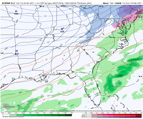
-
February/March 2021 - Frigid or Flop? Pattern/Longterm Forecast Thread.
CG2 replied to John1122's topic in Tennessee Valley
I am with John...not buying the "no precip" scenario just yet. I think it is either going to be cold and precip or warm and precip IMBY. -
February/March 2021 - Frigid or Flop? Pattern/Longterm Forecast Thread.
CG2 replied to John1122's topic in Tennessee Valley
The Euro out to 114 is nearly a textbook overrunning set-up...but no precip. Hmm. -
February/March 2021 - Frigid or Flop? Pattern/Longterm Forecast Thread.
CG2 replied to John1122's topic in Tennessee Valley
I feel like @Stovepipe has something for this....LOL. -
February/March 2021 - Frigid or Flop? Pattern/Longterm Forecast Thread.
CG2 replied to John1122's topic in Tennessee Valley
Looks like someone dumped a pack of Skittles on the map. Taste the rainbow.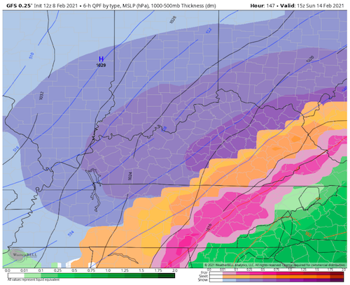
-
February/March 2021 - Frigid or Flop? Pattern/Longterm Forecast Thread.
CG2 replied to John1122's topic in Tennessee Valley
Morning disco out of Nashville.... Upper pattern has shown little consistency between the models over the past runs, even between the models individually. Thursday trough associated with the cold front and push of cold air southward behind is weaker than previous runs, and precip amounts have dropped a little. Instability wants to creep into the south during the day Thursday, so a clap of thunder is not out of the question, but in northern zones, temps will cool near or below freezing, bringing chances not only for a rain/snow mix but even some freezing rain/sleet if the GFS pans out. The GFS is trying to hold onto a sharper cold front with better separation of the surface front/850 mb front, bringing colder air in sooner at the surface and allowing for potential sleet/freezing rain Thursday morning and again in the evening. Still way too soon to call. Friday looks to be dry, and models still disagree on the strength of the CAA behind the front. Not as big of a spread as previous runs, but at least are getting closer to lining up better. Still a slight chance for some snow on the Plateau Saturday night, and models do hint at a Midwest trough again Sunday, but not enough agreement for any confidence on timing. Starting off next week, the only thing that models can agree on is staying in an active pattern, with chances for precip and shortwaves moving through aloft. Based on the low level temperature profile, winter is not ready to loosen its grip just yet. -
February/March 2021 - Frigid or Flop? Pattern/Longterm Forecast Thread.
CG2 replied to John1122's topic in Tennessee Valley
Also out of Memphis...The GFS has trended colder since the was made. .
-
February/March 2021 - Frigid or Flop? Pattern/Longterm Forecast Thread.
CG2 replied to John1122's topic in Tennessee Valley
The 12z Euro has come back to other modeling. Easier now to work through details now that the models are not in two different camps. -
February/March 2021 - Frigid or Flop? Pattern/Longterm Forecast Thread.
CG2 replied to John1122's topic in Tennessee Valley
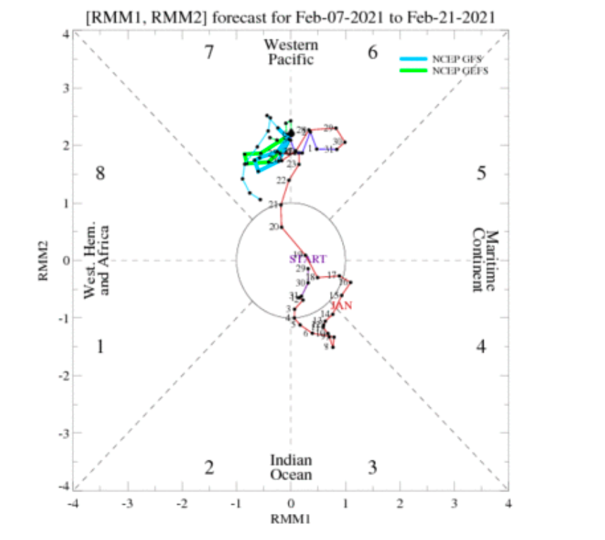
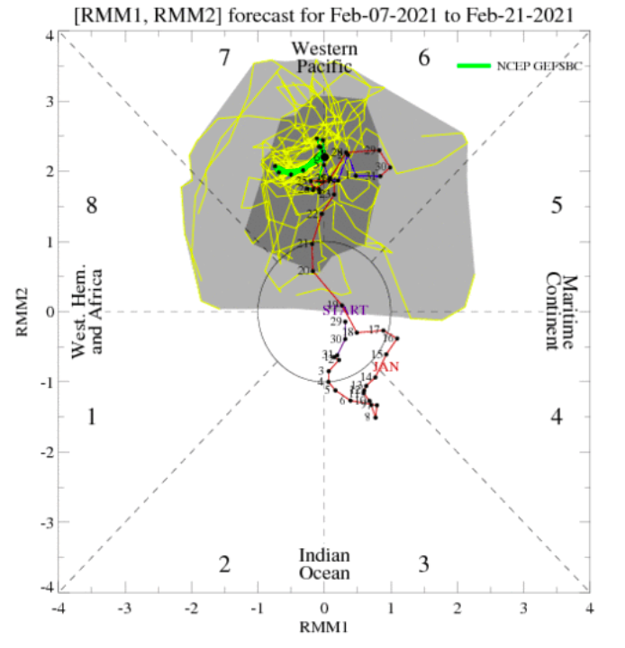
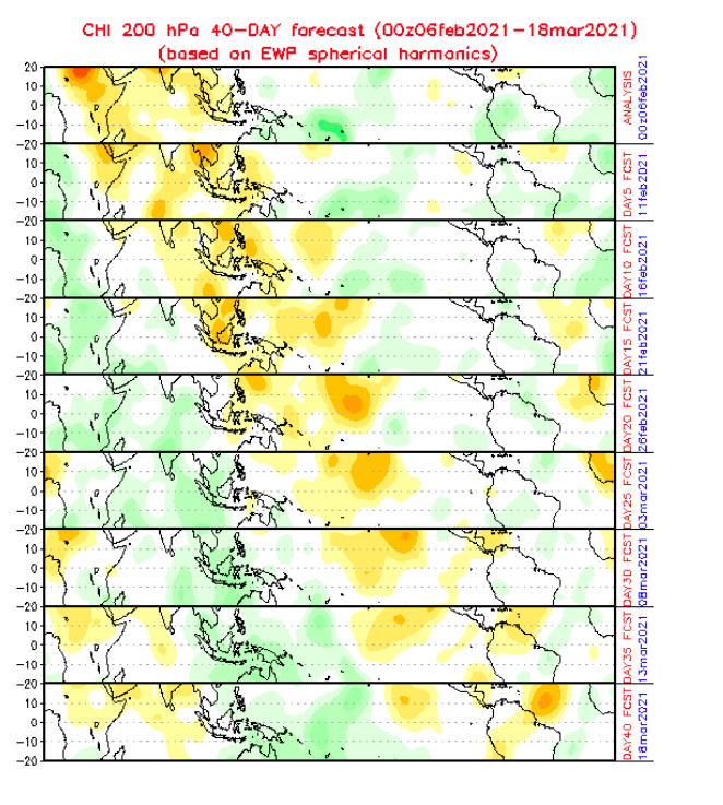
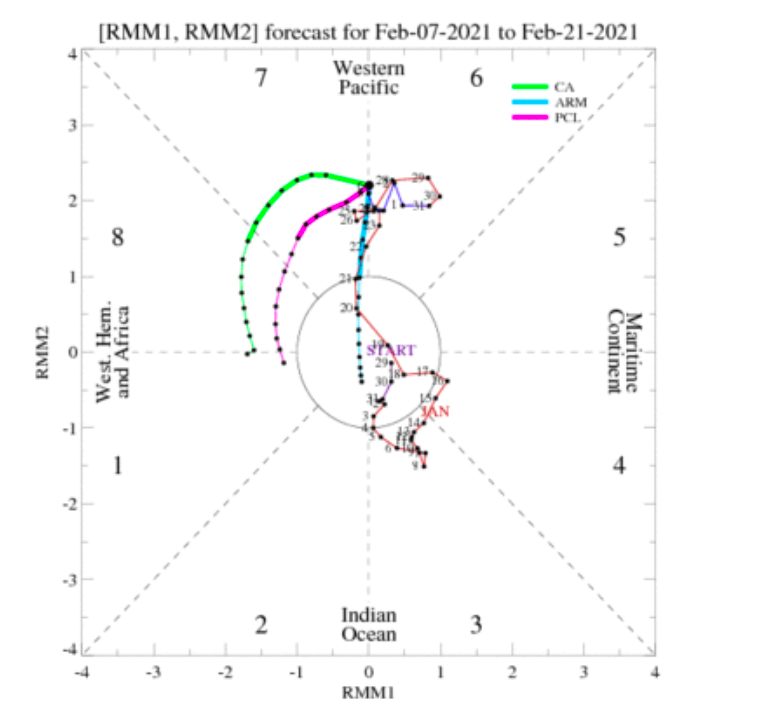
MJO for both the GFS/GEFS and EURO... Note the Euro moving quickly out of 7 and into background phase 8. Makes sense for that model to trend colder. Note the GEFS is stalled in 7... CHI diagram from yesterday...Note the new wave off Eastern Africa which would be phases 1-2. It propagates eastward which I infer to mean the MJO will make another full circuit if that verifies. Will throw in the hi-res GFS/GEFS for good measure...I do NOT like that it appears to curl back. Here is the CA, but it has had a bias for phase 8 all winter(keep that in mind).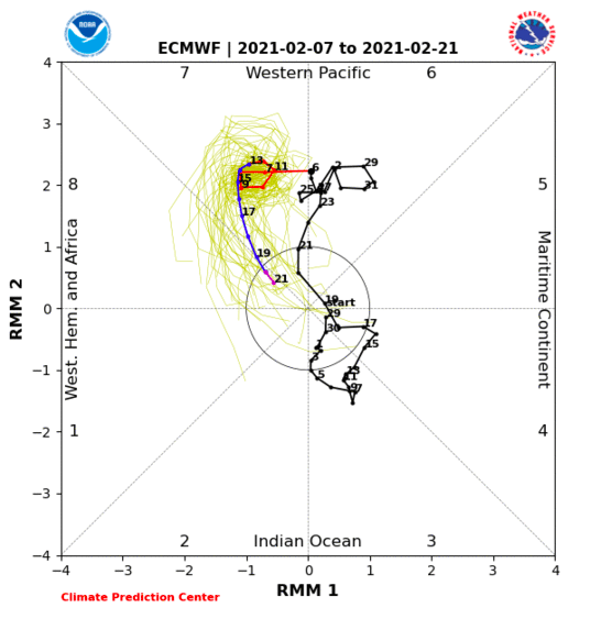

-
February/March 2021 - Frigid or Flop? Pattern/Longterm Forecast Thread.
CG2 replied to John1122's topic in Tennessee Valley
Now, it is very normal for wx patterns do get moved around d6-7. What is interesting, the EURO is more aggressive in moving the MJO out of 7 and into the COD or the lowest corner of phase 8. - meaning background phase is cold at the very least. I told @tnweathernut that I was perplexed that the GEFS was cold while the EPS had the better MJO look...maybe they are now correcting towards a meaningful solutuion. Check out the difference next Sunday in terms of the cold anomalies. The Euro just moved the coldest air from Montana to the Great Lakes. Great pattern if we can get a storm...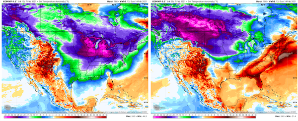
-
February/March 2021 - Frigid or Flop? Pattern/Longterm Forecast Thread.
CG2 replied to John1122's topic in Tennessee Valley
My temp next Sunday just went from 40 to 10 for the low! Now, again there is a storm that almost phases in time for our area...it shoots up the coast and brings the cold down. But this is a great illustration of how I don't think late next week is nailed down yet. The GFS has been adamant that things get pretty wild after Wednesday. The Euro, while not there yet, made a very big move towards the GFS (colder) solutions. Really, the CMC did TR/F but lost the cold over the weekend. -
February/March 2021 - Frigid or Flop? Pattern/Longterm Forecast Thread.
CG2 replied to John1122's topic in Tennessee Valley
Check this R2R change out for later in the day(from what I posted above)...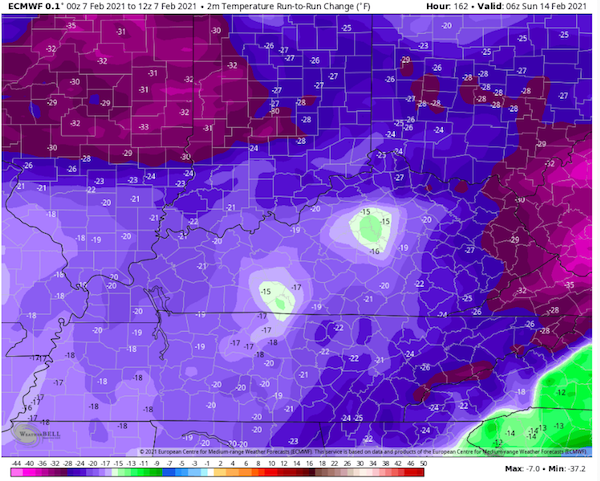
-
February/March 2021 - Frigid or Flop? Pattern/Longterm Forecast Thread.
CG2 replied to John1122's topic in Tennessee Valley
From my bootleg account, here is the run-to-run change for the 12z Euro for next Sunday.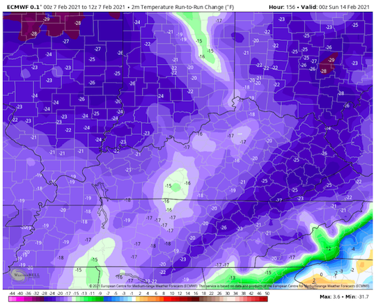
-
Mix here.