

CG2
-
Posts
85 -
Joined
-
Last visited
About CG2

-
Roughly 5-6" snow mean over NE TN / SW VA on both the GEPS and GEFS
-
Agree. The strong NAO seemed to cause a buckle in that block that just didn't allow the cold to spread eastward. If either block had been weaker, I believe we would have seen more cold. As is, if the 12z GEFS is even close to being right, we are about to test that theory. Not sure I have seen a trough dig from the Arctic/Greenland to Cuba. LOL. That is an extreme solution. Probably means it won't verify, but maybe for suppression purposes, we want some modification there! LOL. Fingers crossed for split flow or we are going to be dependent on systems arriving from the Arctic for moisture if the run is taken verbatim. I don't want to see a repeat of 17-18 - cold and dry. With the GOM so warm, have to think some fireworks are sparked. I would not be surprised to see the NAO again later in the season when it is more correlated to cold. As is, the EPO and east Pac AN heights are more traditionally(speaking of La Nina climatology) located for cold than they were in December. Hope that works out. At this point, looks like a pattern change of at least two weeks....TBD after that. And as always....things can and will change. Just have to roll with it.
-
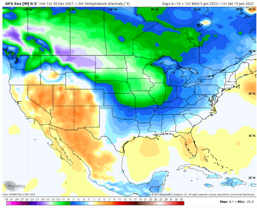
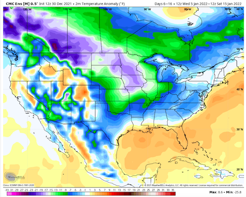
Again, this is Carvers Gap. Just using this account since it has more room for attachments. Looks like cold is locked in for Jan 3-4. Here is the 10day Jan5-15th temp anomaly maps from both the GEFS and GESP. There is even a warm-up embedded in that graphic. BN temps during our coldest weeks of the year. Literally cannot ask for a better temp profile during winter if it verifies.
-
Those are definitely the best. That said, getting an over-running pattern in these dry conditions is tough - dry IMBY. Now, tomorrow, we may experience flooding. Extremes are what we are seeing on modeling right now. I can't begin to state just how tough it is for a computer model to forecast extreme patterns correctly.
-
Agree. There could be some wild temperature gradients with these cold fronts modeled. I am not saying the GFS is right (models which flip like that could flip back during the next run), but verbatim that amount of cold would make us wish for at least a shadow of a SER in order to avoid a suppressed storm pattern.
-
Just for fun, check out the EPO/PNA ridge at 318.....nearly reaches the NP.
-
At this range, completely understandable. They can differ that much even 48 hours out. I mean, it could be gone on the next run with so much variability right now. You are in the cone at least.
-
At least we are tracking cold and snow for your region. Could be worse. The good/bad thing is that this is going to shift all over the place. If modeling today is true, I think there is the possibility for one storm in the western forum area and another further east(possible second cold front) as that type of boundary would likely spawn a heckuva snowstorm. I think the GOM is pretty warm right now. So an Arctic boundary hitting the GOM is fireworks.
-
Don't look now, but the 18z has not one but two storms for west TN. And then the cold hammer drops.
-
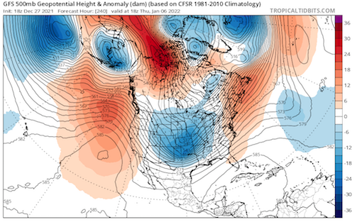
At this point (246), the entire lobe of cold should be jettisoned southeastward into the US. It may or may not be right, but this is more in line with other global modeling AND in line with its own MJO.
-
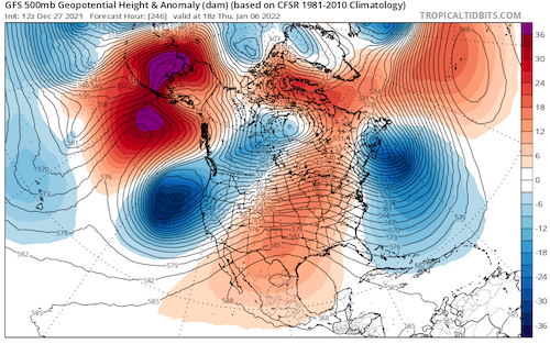
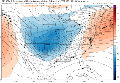
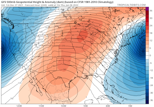
This is the wx pattern over our side of the hemisphere at 240/246. Now, for sure modeling is granted a ton of wiggle room at this range as so many things can influence them. But take a look at the difference that is made when the trough off California is not pumped by the AH. This falls more in line with the 12z EPS. 12z GFS at the top and 18z at the bottom. Notice what happens when the AH is gone and that trough off California moves inland. EPO ridge pops, and we don't even have a -NAO at this point.
-
So, check this out. This is the 12z GFS and the 18z GFS at 222....
-
18z GFS??
-
And there it is at 222, the entire trough comes eastward and settles nicely into the middle of the country where a ridge was at 12z.....a complete and total flip over the United States of what it had at 12z. Replace troughs with ridges and ridges with troughs.
-
Not surprising to see that storm lift north and west. Wouldn't surprise me if it became a cutter. The 12z GFS was off its rocker. The 18z GFS has a run (so far) which is much more in line with other modeling. Trough comes eastward this time instead of meandering of the coast of California. Let's see how this run looks with that seemingly corrected(again, who knows, earlier runs may have been right).


