

TimB
-
Posts
17,206 -
Joined
Content Type
Profiles
Blogs
Forums
American Weather
Media Demo
Store
Gallery
Everything posted by TimB
-

Pittsburgh/Western PA Spring 2023 Discussion
TimB replied to Ahoff's topic in Upstate New York/Pennsylvania
Just looked at the stats for PIT and we have had exactly two hourly observations with a dewpoint of 60+ in 2023: 9pm on April 5th (61) and 3pm on May 13th (60). That’s it. -
Pittsburgh/Western PA Spring 2023 Discussion
TimB replied to Ahoff's topic in Upstate New York/Pennsylvania
I know you’ll enjoy hearing that Burlington, VT has hit 95. -
Pittsburgh/Western PA Spring 2023 Discussion
TimB replied to Ahoff's topic in Upstate New York/Pennsylvania
2020 did not. That was a cold airmass. Doesn’t look like any of the others featured a high above 75. Most of them had lows in the mid 30s to low 40s. -
Pittsburgh/Western PA Spring 2023 Discussion
TimB replied to Ahoff's topic in Upstate New York/Pennsylvania
Today could be the best diurnal range of this stretch at PIT. Low this morning was 51. -
Pittsburgh/Western PA Spring 2023 Discussion
TimB replied to Ahoff's topic in Upstate New York/Pennsylvania
Trying to decide if I had the choice between another 384 hours with no rain or some rain but probably higher dewpoints, which one I’d take. I think probably the dry one, but the implications might be a little worrisome. -
Pittsburgh/Western PA Spring 2023 Discussion
TimB replied to Ahoff's topic in Upstate New York/Pennsylvania
Underperforming on high temps this week at PIT. Something to watch on these hot days coming up. -
Pittsburgh/Western PA Spring 2023 Discussion
TimB replied to Ahoff's topic in Upstate New York/Pennsylvania
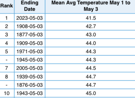
Here it is in all its glory:
-
Pittsburgh/Western PA Spring 2023 Discussion
TimB replied to Ahoff's topic in Upstate New York/Pennsylvania
GFS is also wet. 0z had nearly 3” of rain through 240. -
Pittsburgh/Western PA Spring 2023 Discussion
TimB replied to Ahoff's topic in Upstate New York/Pennsylvania
Definitely something to watch. The cool period next week has completely disappeared from the Euro. It’ll be interesting to see how it plays out. -
Pittsburgh/Western PA Spring 2023 Discussion
TimB replied to Ahoff's topic in Upstate New York/Pennsylvania
I’ll add that the period from 1995-2012 is the longest Pittsburgh has ever gone without reaching 97 or higher. And now we’re already up to 11 years again. -
Pittsburgh/Western PA Spring 2023 Discussion
TimB replied to Ahoff's topic in Upstate New York/Pennsylvania
Our first GFS clown range triple digits of the season appeared this morning. -
With my city entering its sports dark ages, Boston not winning championships is all I’ve got.
-
Pittsburgh/Western PA Spring 2023 Discussion
TimB replied to Ahoff's topic in Upstate New York/Pennsylvania
I often find myself wondering “how common or rare is it to be this warm or cold or wet or dry or snowy or snowless” and that place usually has the tools I need to answer that question. -
Pittsburgh/Western PA Spring 2023 Discussion
TimB replied to Ahoff's topic in Upstate New York/Pennsylvania
https://xmacis.rcc-acis.org This is the site I play around with to get that kind of data. Fairly straightforward to use once you get the hang of it. -
Pittsburgh/Western PA Spring 2023 Discussion
TimB replied to Ahoff's topic in Upstate New York/Pennsylvania
Record is 26 days in Oct-Nov 1874, followed by 25 days in Aug-Sept 1995. There are about 70 dry spells of 14+ days on record, most of them occurring in the fall. Now if we’re talking spring dry spells, that 14 day dry spell in May 2021 was actually the longest spring dry spell in almost 80 years. -
Pittsburgh/Western PA Spring 2023 Discussion
TimB replied to Ahoff's topic in Upstate New York/Pennsylvania
All 92+ in May were recorded 1942 or prior. There are a number of such temps at prior observing sites, including a monthly record of 95 that was reached as early as 5/2/1887. -
Pittsburgh/Western PA Spring 2023 Discussion
TimB replied to Ahoff's topic in Upstate New York/Pennsylvania
If 92 is reached on Thursday, it’ll be the earliest at PIT. -
That’s the other thing. Actual extreme heat in western vs. central PA looks different. 97 and above isn’t uncommon at MDT, and in fact recently seems to occur in as many summers as it doesn’t. PIT has only reached 97 in one summer (2012) since 1995.
-
That was two whole years with no 90s or even 89s. Probably impossible now, though I would have also thought it impossible then.
-
2003 and 2004 were both lacking in the heat department in PA. The latter especially. A tied for record-fewest 3 90 degree days in 2004 at MDT, and PIT never got above 87 (a record). 2003 only performed slightly better in the heat department. 6 90 degree days at MDT, and PIT’s max was 88 (tied for 2nd with a couple years in the 1970s).
-
Pittsburgh/Western PA Spring 2023 Discussion
TimB replied to Ahoff's topic in Upstate New York/Pennsylvania
-
Pittsburgh/Western PA Spring 2023 Discussion
TimB replied to Ahoff's topic in Upstate New York/Pennsylvania
Wildfire smoke. Always seems to affect temps more than expected. -
Pittsburgh/Western PA Spring 2023 Discussion
TimB replied to Ahoff's topic in Upstate New York/Pennsylvania
Not complaining, but wasn’t today supposed to be gross? It’s perfect. -
Pittsburgh/Western PA Spring 2023 Discussion
TimB replied to Ahoff's topic in Upstate New York/Pennsylvania
-


