

SnowenOutThere
-
Posts
5,448 -
Joined
-
Last visited
Content Type
Profiles
Blogs
Forums
American Weather
Media Demo
Store
Gallery
Posts posted by SnowenOutThere
-
-
Out in the greens with yellows approaching in Reston and the flake size has increased significantly
-
 4
4
-
-
2 minutes ago, nj2va said:
Greens look like they want to build back over DC/Arl/Alexandria.
And some yellows added in too
-
1
-
-
5 minutes ago, Ji said:
Why did CWG call for 1-2?
They’re going down with the ship too, their 8pm update said 1-2 more inches overnight …
-
Went on an hour long jebwalk and got a friend to accompany me for 1/3 of it (and a brief snowball fight). Just reached 3.5 with .5 of that in the last 20 minutes
-
5
-
-
1.75 out near Reston with .8 of that coming from the second round
-
1
-
-
With all the posting going on don't forget to go out an enjoy the snow! Also go OHS Swim&Dive @NorthArlington101

-
3
-
-
15 minutes ago, MN Transplant said:
The 3km NAM from 12z gives us 3+ inches of snow. Through 4pm it had 0.01” qpf. This is all just bonus scenery snow.
Very nice knowing that anything we get before 4pm is just a bonus
-
28 minutes ago, Terpeast said:
Think I’ve reached an inch, or will soon.
Light snow 27/24. Sidewalks are gone, road is stubborn
Interesting how sidewalks have caved in Ashburn but out 3 east of Dulles they’ve continued to melt.
-
Took an amazing hour nap after a bike ride in the snow and rates have picked up. First time during the day that visibility has gone down
-
47 minutes ago, JenkinsJinkies said:
Gone are the days where a 12"+ storm will give kids a week off. I got a week off Senior year from the 2016 storm, so I got to experience the last of it.
Fcps for once (maybe first time ever???) made a good decision: Fairfax County Public Schools announced that the school district will be reverting to its former policy for snow days for the 2023-24 school year. This decision means there will be no virtual learning days when school is closed due to inclement weather.
-
Just now, BTRWx's Thanks Giving said:
That one looks like it's from yesterday.
It says issued Jan 15th 9am so unless time itself has changed I think we’re good
-
1
-
-
3 minutes ago, Ravens94 said:
Slowly coming up

And I believe that’s on top of the mostly area wide (my condolences@North Balti Zen) .5-1 we’ve already had
-
1
-
-
Just now, BTRWx's Thanks Giving said:
That's odd. I'm seeing a different map for the same map time.
It updates differently, had the same thing happen to me yesterday
-
10 minutes ago, psuhoffman said:
Both the ARW1 and 2 are crazy considering those are 10-1
So I’m getting at least 7 inches of snow thanks got. I guess if psu says so it must be true
-
1 minute ago, Terpeast said:
Fine light snow falling again
Wonder if this will be an off and on sorta deal till second round as radar continues to show light returns streaming in from the west
-
2
-
-
Must have gotten good banding first round with .9 inches of extremely light snow covering everything (including pavement
")
-
3
-
-
Woke up for swim practice and absolutely beautiful outside and all of the roads have caved. Looks like this light snow continues for a good many hours too!
-
2
-
-
NAM manages to get .5 + qdf in the cities by the time it’s all over
-
1
-
-
3 minutes ago, aldie 22 said:
Maybe the 18z GFS will make you pass out
Or throw up …
-
 1
1
-
-
I love when even the “best” case scenario (for “normal” people that is) is still 3 inches of snow!
-
2
-
-
If we get the coastal to come back from the grave this is going to be the craziest reverse coup seen by the gfs, like some Trojan horse type shit.
-
1
-
3
-
-
4 minutes ago, NorthArlington101 said:
It could be ptype BS, but it’s “ice” for everyone outside the mountains. Rain as you go SE of DC
Flips back to a little snow at 54As someone who really wants to miss school this week I see this outcome as an absolute win
-
5 minutes ago, nj2va said:

The 12z Euro was pretty good 1-3 I think so just need it to follow the general 0z trend
-
10 minutes ago, baltosquid said:

further improvements to the 10:1 mean at 18z.
12z and 18z really brought the Gefs back from 1.5 inches at DCA to 2.5 inches, at this point ens are out of their range but still nice to see


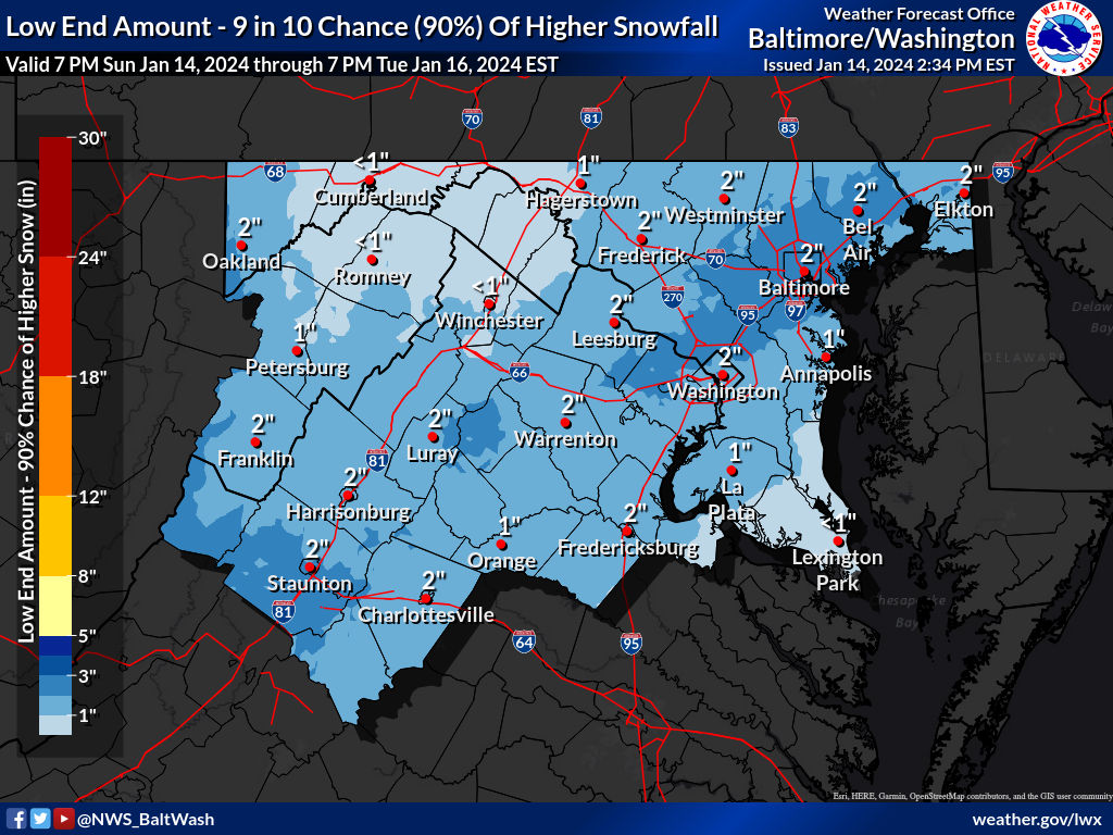
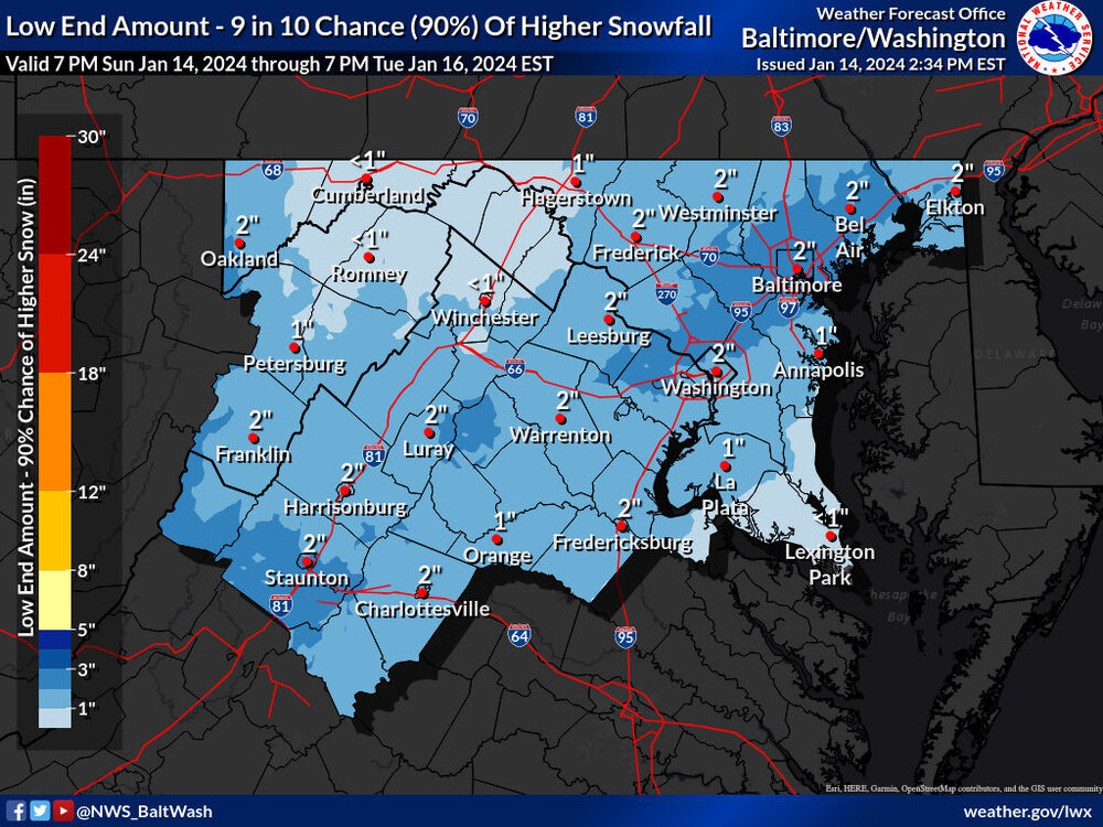
Jan 15-16 Storm Thread 3: Obs and Disco
in Mid Atlantic
Posted
For anyone wanting coastal enchantment be warned as it is freezing rain even on the fairfax louden county boarder