

SnowenOutThere
-
Posts
4,006 -
Joined
-
Last visited
Content Type
Profiles
Blogs
Forums
American Weather
Media Demo
Store
Gallery
Posts posted by SnowenOutThere
-
-
39 minutes ago, WxWatcher007 said:
You set up an email account at the age of five?
Fine, younger me
-
 1
1
-
-
Yeah going to make a new email because my normal one has my personal info in it (great idea 5 year old me). Will get around to setting a new one up in a day or so.
-
On 10/31/2021 at 10:23 PM, George BM said:
Forecast Discussion
November 24 2021 1:53PM EST
A late November 1950-like storm is beginning to take shape as the strong ridge of high pressure that built up over western North America is forcing a deep trough with arctic air southwards from the Arctic and into the region this afternoon accompanied by a strong shortwave riding the polar jet stream. At the same time a healthy southern stream system is currently moving off the Carolina coastline. These two systems will phase with each other over the next 24 hours or so leading to explosive deepening of the coastal low during that time. In fact, most models have the low deepening from 1001mb as of 18z (1pm local time) to near 950mb by 18z tomorrow when the low will be centered over the Delmarva peninsula. This will be a high to extreme impact event for the entire region.
Through tonight:
Snow showers will start to develop over the towards dusk as an increasing S/SErly flow aloft brings in moisture over the colder airmass. Temperatures will fall through the 30’s and into the 20’s by 00z. As the night wears on, snow and wind will increase in intensity as temps fall into the teens. A Blizzard Warning will go into effect at 8z when winds will start to frequently gust over 35mph with snowfall rates surpassing 2”/hr leading to visibility dropping to below a quarter mile.
Thanksgiving Day and night:
This will be a very memorable day weather-wise. Temperatures will stay in the lower 10’s along and west of I-95, perhaps even dropping into the upper single digits towards the 1-81 corridor leading to wind chills near 10 to 15 below zero. There will be a sharp temperature gradient probably greatest over the Chesapeake Bay with temps along the western shore not getting above the lower 20’s while temps over the Delmarva get well up into the 40’s to perhaps the lower 50’s with precip becoming all rain in that region during the day. For the rest of the region, however, extremely heavy snowfall and damaging winds will be the main story. With the warmer than normal western Atlantic waters and the very impressive dynamics of the storm, liquid equivalent rates may get as high as 0.5-0.75”/hr. With strong lift through the DGZ layer (~ -12 to -18C) snow to liquid equivalent ratios will be in the 15-20 to 1 range. As a result, snowfall rates may exceed 10”/hr in the heaviest snow bands. At the same time winds will gust over 70mph during the day with 100-120+kt low-level winds in place around the western side of the low. Once the low starts to pull away from the region during the overnight hours 5 to 8 feet of snow should be commonplace with 15+ft drifts.
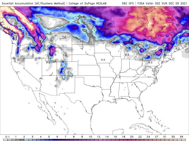
Found an ai text generator to add to the forecast and it made this. A little stunned how well it replicated the text.
Black Friday and the weekend:Once again the strong wind gusts will continue and it will not be out of the ordinary to have winds gusting over 50mph with 50+ mph gusts as high as 70mph for at least a couple of hours along the coast. Winds from the north during the day will increase into the 30-40mph range with gusts near 50mph in the evening. Friday night through Sunday morning should be the time for any lingering tree limbs to come down so make sure you give the snow plows plenty of room to work along and down the blocks.During the day Saturday all of the coastal counties (as well as far SE Mass) will have a chance of seeing a period of flurries, but any snow is expected to be very light and brief. An icy mix is possible along the coast, but the best chance for frozen precipitation will be for southern New England. As the storm pulls out during the afternoon, high temperatures will be in the mid to upper 30’s with a frigid wind chills in the 20’s.Sunday will be cloudy with scattered light snow showers. The temps should be able to get above freezing in the afternoon. Any accumulating snowfall will be mainly confined to the interior and especially the northern third of New England. Any slush/wet spots on roadways will quickly freeze and snow covered surfaces will become treacherous.Following the storm winds will continue to be a problem-
 1
1
-
-
Didn’t hit us but amazing storm north of our area and thought I should share.
-
8 minutes ago, MN Transplant said:
That is a sad OP run for getting into early Dec.
It has cold but no storm systems to take advantage of it.
-
The media is the true weenie
-
2
-
-
Took this right before swim practice.
-
2
-
-
20 minutes ago, peribonca said:
I'm getting excited about seeing our first flakes Tuesday or Wednesday!
Yeah seems to be a decent chance that we might get some lake effect bands after the storm comes through. Though it is lake effect so you got to be lucky to get anything.
-
25 minutes ago, StormchaserChuck! said:
Models look juicy for 1st week of December! I can't see us getting over 2-4" max
Why are you posting about the first week of December on the 17th? The patterns aren't even set in place, yet alone a storm.
-
1
-
-
2 minutes ago, LP08 said:
Details be damned, that's a good look at 500.
Ninja'da good look but we would need luck for it to give us anything good which tends to not be in our favor.
-
5 minutes ago, LP08 said:
Hey GFS…you are about a month to early for this…thanks.

Even then it would only be a front end thump before it switches to rain with the low going west of the mountains.
-
This is the one, it’s so absurdly stupid that this has to be the way we get snow.
-
1
-
4
-
-
1 hour ago, nj2va said:
Only 24 more runs of the Euro to go!
Lock it in
-
This is the one
-
3 minutes ago, WinterWxLuvr said:
I’ll predict Thanksgiving… partly cloudy, windy, highs early low 50’s falling to low 40’s by late afternoon. Let’s see how a WAG compares to models 2 weeks out.
I'll go for colder than normal maybe 40s to 30s with a northwest wind and some flurries due to lake effect after a front. Sort of wishcasting though.
-
1
-
-
20 minutes ago, clskinsfan said:
Happy Turkey day!

I'd take some mood snow on Thanksgiving
-
2
-
-
12 minutes ago, NorthArlington101 said:
You'll be faster than me in no time! Think I peaked at a 48.2... good luck.
That's a crazy good time, did you get it in highschool or post highschool?
-
8 minutes ago, GramaxRefugee said:
.....with numbers like that.
You were shooting for 55 (I think). I don't pretend to know what's a top number, but don't sell yourself short. Aim high.
From the people who tried out for the team I think I was top 8 overall which is pretty good because it's my first year trying out and I am also trying out against seniors so I did pretty well. I wanted to go for a 55 and below because that would get me on the team but my previous best was a 53, for swimming a whole second of time drop is pretty good so I'm happy with my swim.
-
2
-
-
Only got to swim 100 free yesterday and will be the first heat of 100 breaststroke today. I got a 52 in the 100 though so I am almost guarantied to be on the team.
-
9
-
-
4 minutes ago, NorthArlington101 said:
Weird system. I guess the fast people are generally fast at freestyle, but you could have a killer breaststroke and be terrible at free, in theory.Yeah you have to swim 50 and 100 free and the 100 free determines if you make the team but you can also optionally swim 2 100s of any stroke. So I think if you are on the edge but have a super good breaststroke you make the team while if you only swam free you would have been cut.
-
4 minutes ago, NorthArlington101 said:
You guys have tryouts? My high school took literally everyone for swim
Only the top 30-32 boy and then the top 30-32 girls to make the team, the cut tends to fall around 55-57 seconds for the boys so I have to ideally get below at least 55. As I said earlier it is our 100 free time that determines it.
-
Have tryouts for high school swim team today. A little nervous I have to go a sub 55 to make the team for a 100 free and my best is a 53 but I swam it 6 months ago so it should be faster now. Just nervous that my googles might break or something.
-
2
-
-
 That is straight up sad
-
1
-
-
The models coming out a hour earlier is such a great thing.
-
6
-

December 2021 Medium/Long Range Discussion Thread
in Mid Atlantic
Posted
Have been following the (threat?) next week for a bit but almost all of the gfs runs have the storm never quite survive and has it reform too Far East. What’s the difference in pattern that is causing the Euro to support it while the GFS has the low die off?