
PantherJustin
-
Posts
738 -
Joined
-
Last visited
Content Type
Profiles
Blogs
Forums
American Weather
Media Demo
Store
Gallery
Posts posted by PantherJustin
-
-
4 minutes ago, WinstonSalemArlington said:
Where is everyone? The other weather board is hopping tonight.
What other forum? I’d love to join Bc it’s gotta be better than this. This forum used to be awesome now it’s lame
-
 1
1
-
 1
1
-
-
I see we got the Crybaby’s and know it alls in here tonight … I will post it here so no one gets their ass on their shoulders
-
1
-
-
5 minutes ago, SouthCentralWake said:
You literally posted an HRRR model run 3 hours ago
Yea because people were crying about the Banter … so I figured I’d atleast try to soothe them with weather talk … I mean god forbid we don’t breakdown every token model run for a Rain/ 1” event my bad
-
 1
1
-
-
1 minute ago, wncsnow said:
Most models had us getting a very quick changeover up here in the foothills yet it rained .10 here too before ending as a few flurries. Cold just doesn't make it over the mountains well. We need CAD.
Silly forum…. models are for Weenies NC Winter Rule #1…..Cold Chasing QPF = LOSS 99/100
-
3 minutes ago, SouthCentralWake said:
Wrong. All the short range models including the HRRR leading up to now always showed it starting later and it was always gonna start as rain.
HRRR also showed an unrealistic scenario of everyone dropping from Mid40s- 30 with light rates….Not once since yesterday has anyone been modeled more than .2 QPF in CLT metro and that’s on the over juiced Weenie Hrrr …. Not crying just saying like @wncsnow said earlier I saw this coming all day …. Light QPF does not cool fast enough it simply can’t
-
35 and pouring rain…. This one’s over here in CLT metro Back edge Screaming East, glad we wasted the .10” qpf we did get as rain… fun times
-
 1
1
-
-
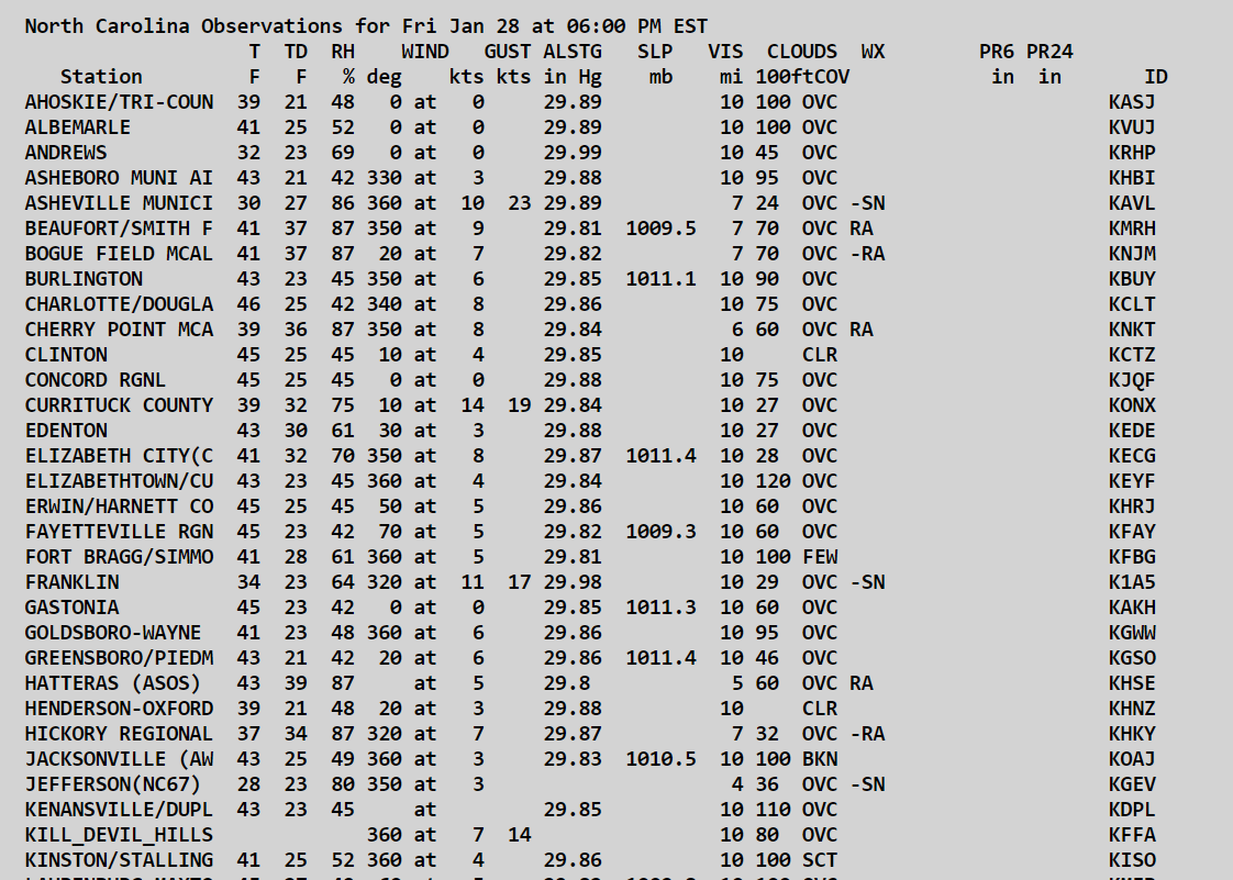
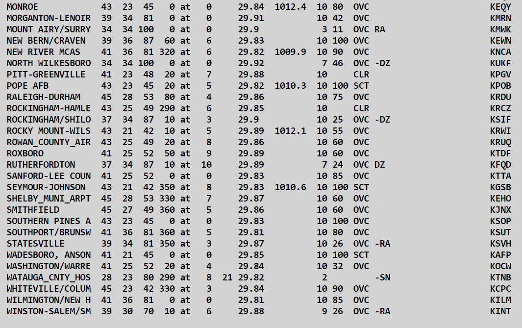
3 minutes ago, Avdave said:
6pm obs statewide
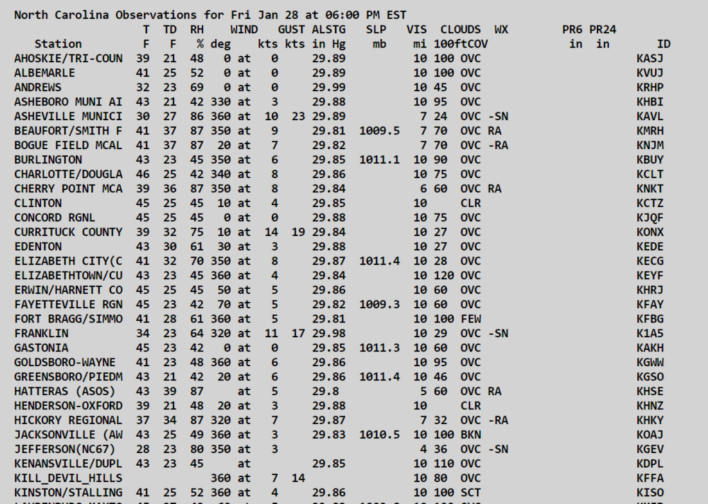
Yikes…. 45-47 Gastonia, CLT, Concord … it’s 40 here in Mooresville… I can see 38 in Statesville, and 38 in Troutman so it’s working in I guess
-
 1
1
-
1
-
-
Ik he’s a northern Guy but he’s right… and seeing Twitter reports of SN coming down at a nice Clip in Hickory/Pilot Mt from @TimBuckley
-
2
-
-
7 minutes ago, wncsnow said:
I think BL temps are gonna waste most of the moisture for Piedmont folks
Especially 77 Corridor…. Everyone still 40-45
-
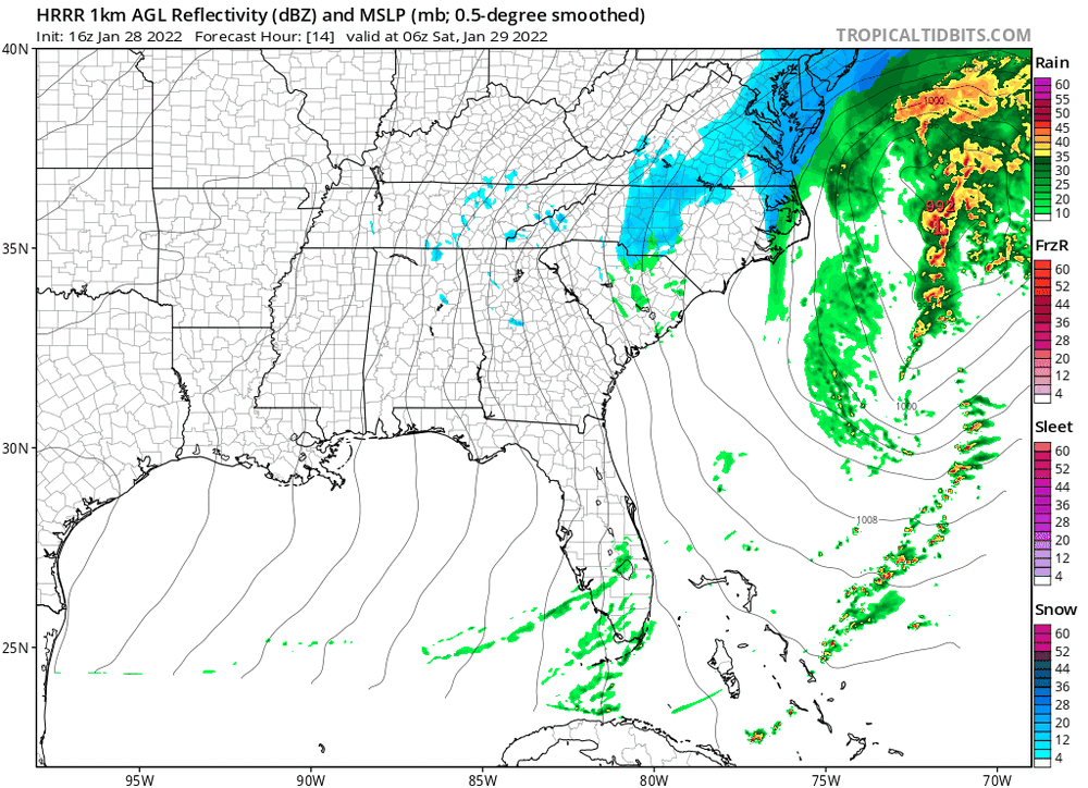
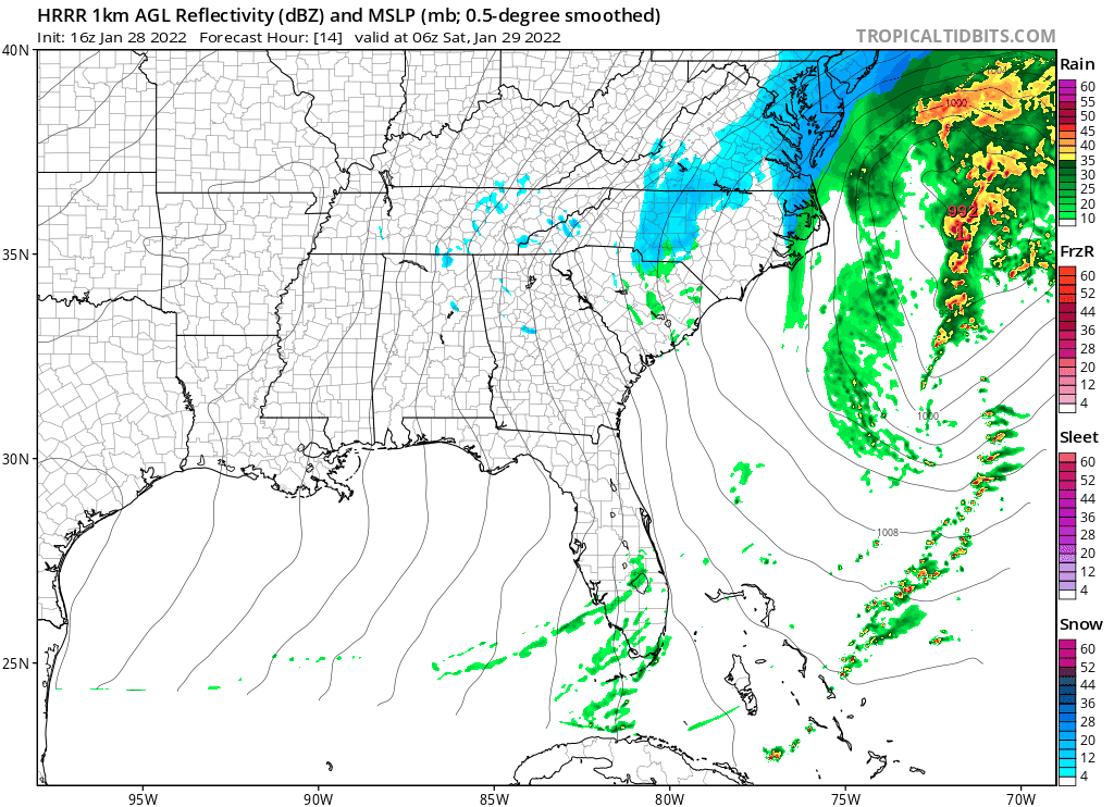
Fwiw… 21Z rolling now…. Hrrr has been rather consistent for the band placement ect. This is 1AM tonight over it’s last 5 cycles…. This run a tad Juicier than last. I chose 1AM bc it seems to be when it finally gets its act together and begins to pivot thru our forum
-
1
-
-
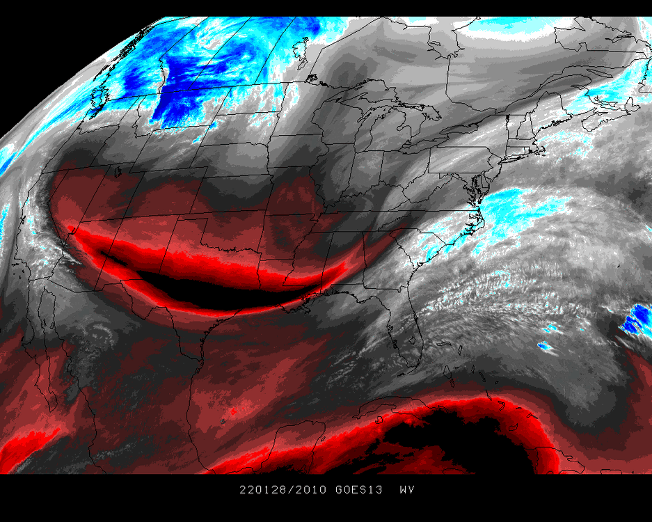
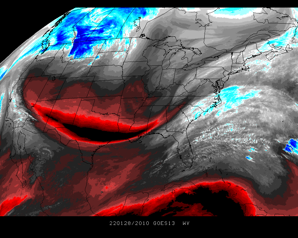
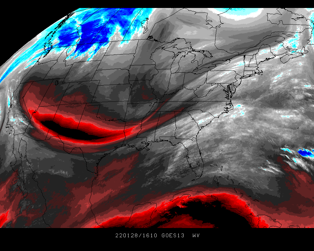
Someone more qualified than I… but I believe we’ve got our phase … this is Current Water Vapor… decent digging (won’t matter for us) but not terrible look …. To me not far off from NAM run from a few days ago… I’m a weirdo I keep screenshots to compare after storms

-
3
-
-
8 minutes ago, Blue_Ridge_Escarpment said:
If Roy is in the building State loses. Been that way for over 15 years now.
Yea, except for Keatts first year, other than that I literally can’t say a word ….Roy owns us like the Warm nose owns Wake county
-
1
-
-
Ok …. Greater chance of occurring…. Someone gets 3-6” in this Mystery band none of us can see, or NC State “Upsets” (If you wanna call it that) UNC Tomm in the Dean Dome while they honor Ole Roy?… or Option 3 I just lose everything this weekend

-
Did pretty decent last week So I will try again…. And Surrounding areas
CLT - Dusting - 2”
GSO- 3-4” (Ik Ik just trust me)
Winston - 2-4”
Triangle - 1-3”
And our Jackpot Winner by Tomm AM…. Asheboro/High Point 5” (Someone in this area S ish of Downtown GSO)
-
4
-
-
1 minute ago, LakeNormanStormin said:
Still think we could wind up with up to two inches in the Lake Norman area. That deformation band is gonna unload on the corridor for at least 2 hours before it moves east of us.
Hope so …. I mean it is 46 degrees though over here in Curtis pond …. Quick someone say something about current soul temps so it feels like a real Rain to snow setup

-
1
-
-
Pretty Much anywhere N of I-40/yet W/NW of Durham is safe in most every event
-
Is there a massive eye roll emoji? I hope it catches a random Headwind and blast the 7 ppl that live in Halifax Novia Scotia and Boston gets a token dusting
-
5 minutes ago, StantonParkHoya said:
Roxboro, Aspen of CNC
Seriously though? Roxboro, Or like Eden or Elkin/Mt Airy which one would you put money on nearly any setup?
-
Just now, WeatherHawk said:
33 here and moderate snow failing, large nickel and quarter sized flakes.
7 miles N of Boone, Meat Camp at 3646’Meat Camp lol
-
1
-
1
-
2
-
-
Does anyone ever score as much as Greensboro
…. I mean a CAD event… Golden, A coastal? Itl throw more back west enough to get 2-3” a random Deform? Yep lol
-
1
-
-
I have a feeling I-77 is gonna get the Middle finger
-
17 minutes ago, olafminesaw said:
Are we quite sure it's not an opening into the underworld?
Any reports out of West Texas Of ppl disappearing
-
1
-
-
-
3 minutes ago, Sandstorm94 said:
Might get a slightly earlier phase...
Sent from my SM-S115DL using Tapatalk
It looks like it’s trying to phase in that pink area back towards Ark/LA …. If you look at the current surface, yet again 12Z NAM did not initiate correctly, it shows flatter heights than what’s actually there
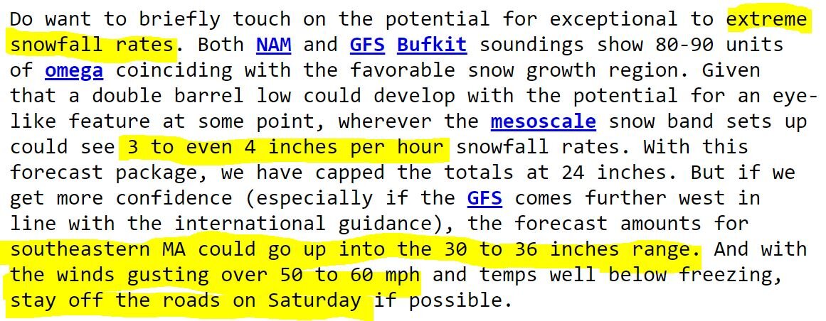
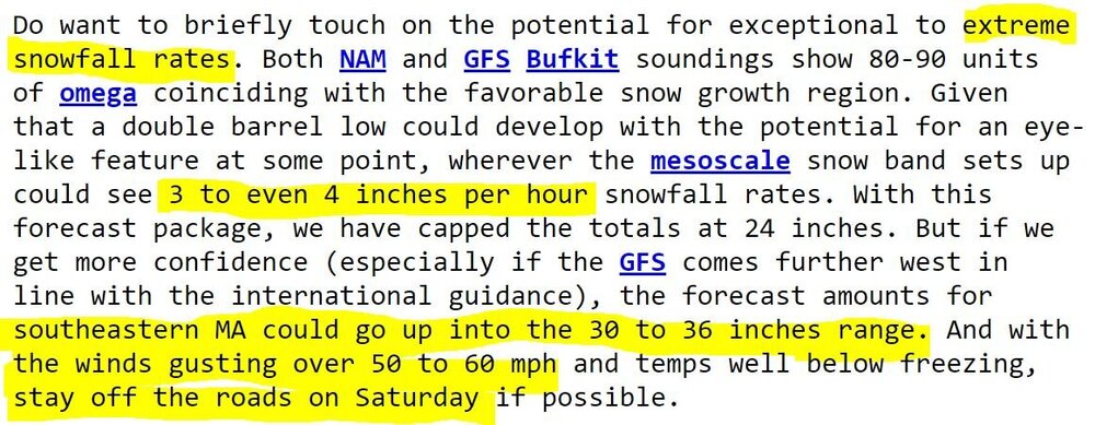
Powerful Multi-regional/ multi-faceted east coastal storm now above medium confidence: Jan 29 -30th, MA to NE, with snow and mix combining high wind, and tides. Unusual early confidence ...
in New England
Posted
So did y’all see it’s gonna go East and blank all of us ?