
PantherJustin
-
Posts
738 -
Joined
-
Last visited
Content Type
Profiles
Blogs
Forums
American Weather
Media Demo
Store
Gallery
Posts posted by PantherJustin
-
-
6 minutes ago, BornAgain13 said:
That would actually be funny to me cause Brad Panovich this morning pretty much Said it just isn't much there.
Can’t blame him…. WPC even removed all of their prediction products for CLT and most of Nc … Brad was The first one to ever be responsive with public on Social Media, nothing but respect, but when I first started following in Late 2000s he was a giant Weenie would be first to hype ect, now he’s lowest until Everyone else does
-
 1
1
-
-
2 minutes ago, olafminesaw said:
GFS stops the bleeding a bit. Very similar to 6z, but nearly gets enough tilt towards the end to get the precip shield north.
Yea, looked halfway decent …. Man would love to see EURO jump on though
-
56 minutes ago, Brick Tamland said:
Well, since you know what's going to happen no sense in wasting your time on here.
I’m glutton for punishment, and I’d love to eat crow on this
-
 1
1
-
 2
2
-
 1
1
-
-
Just now, Brick Tamland said:
Don't forget how the storm we had just two weeks ago looked only 48 hours out. Completely changed with 24 hours to go after it was showing it way east.
Yea…. But the point is with every storm this 4-5 day period comes and ALL of them except Jan 15th event go to the flat progressive look ….we say this every time “ohh the NW trend” the NW trend hasn’t existed for 3 weeks now and won’t exist here either…. Not trying to be a pessimist just saying I’ve been fooled 2x now on this same thing, not happening again
-
2
-
1
-
-
1 hour ago, olafminesaw said:
Yeah...not a great trend. The door is open, but closing fast. There's hope through at least the 0z trends tonight though

These beach sliders are getting old ….
-
2
-
1
-
-
25 minutes ago, WXNewton said:
Yeah not a good sign for those of us back to the west, esp when op run and ENS start to zero in together or atleast come closer together. Also the 18z EURO lines up pretty well with the GEFS and UKMET tonight.
The mean does yes…. But still a handful of Jacked up Big dogs in the Ensemble’s…. For now
-
These southern sliders …. Gross, I mean who won the lotto down in Freaking Cheraw

-
1
-
-
3 minutes ago, WXNewton said:
Congrats upstate SC that run and east of 85, def. trended more suppressed south and east. Earlier on in the run upper level went neutral faster but actually went negative later than 18z did.
Yea… Congrats Bennetsville/Wadesboro ect….. again smh
-
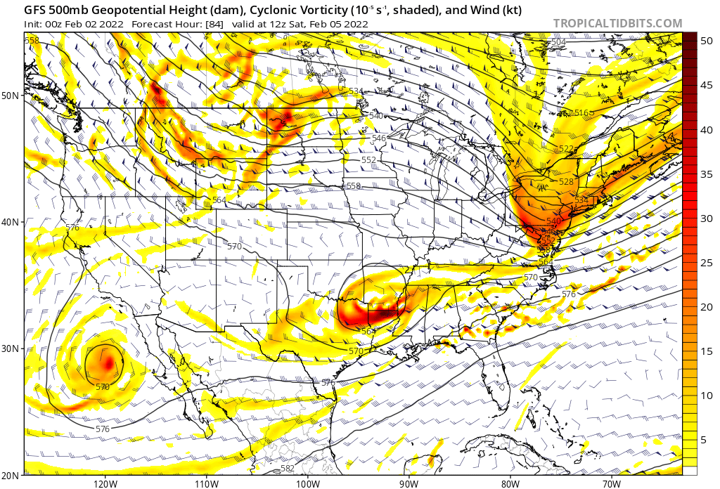
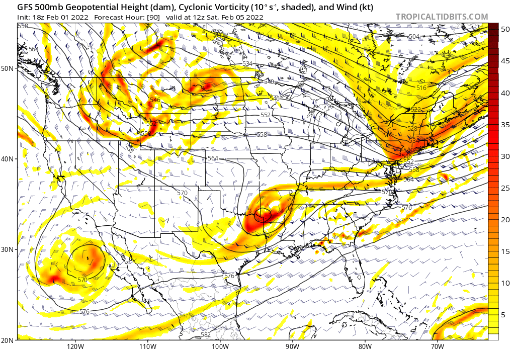
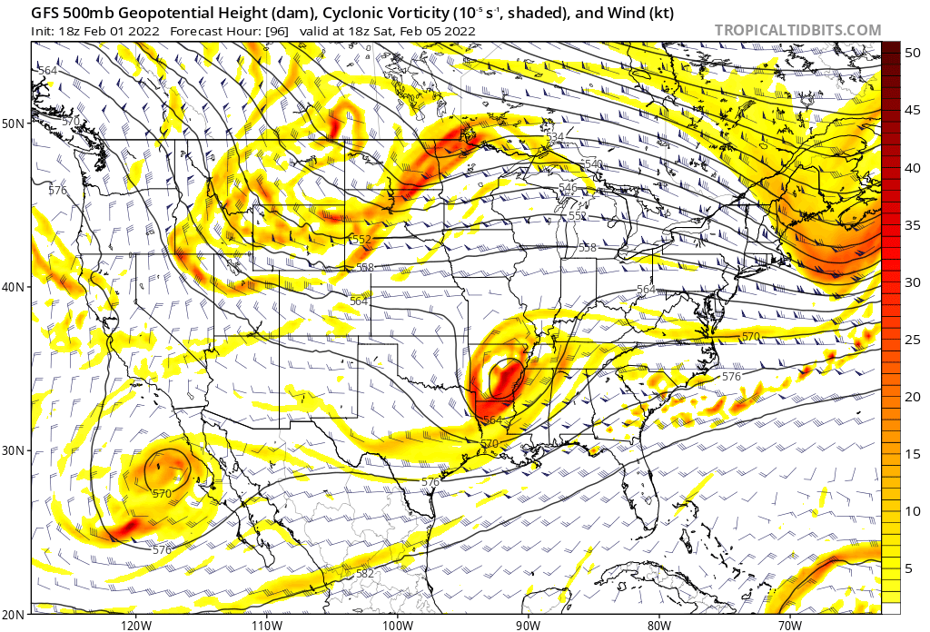
At 96 that 1037HP is now over PA/NY border instead of NY/VT/MA area
and from What I can tell it’s gone by 102 lol
-
0Z 84hrs

18Z on the bottom at 90 (same time)
-
5 minutes ago, Sandstorm94 said:
What a beautiful bowling ball

Sent from my SM-S115DL using Tapatalk
Well I guess im staying up till 2AM
-
2
-
-
17 minutes ago, Sandstorm94 said:
Considering my hot streak...
Do I start the thread or wait
Sent from my SM-S115DL using Tapatalk
Lord no …. Lol no threads till atleast 3-4 straight Runs of agreement imo
-
5
-
-
4 minutes ago, BornAgain13 said:
Would love for the GFS to be right but I really hate the Euro isn't on board.
Yea ….. I’d love for anything else to be on Board at this point . Crazy it won’t budge though
-
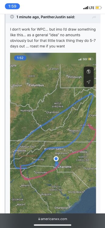
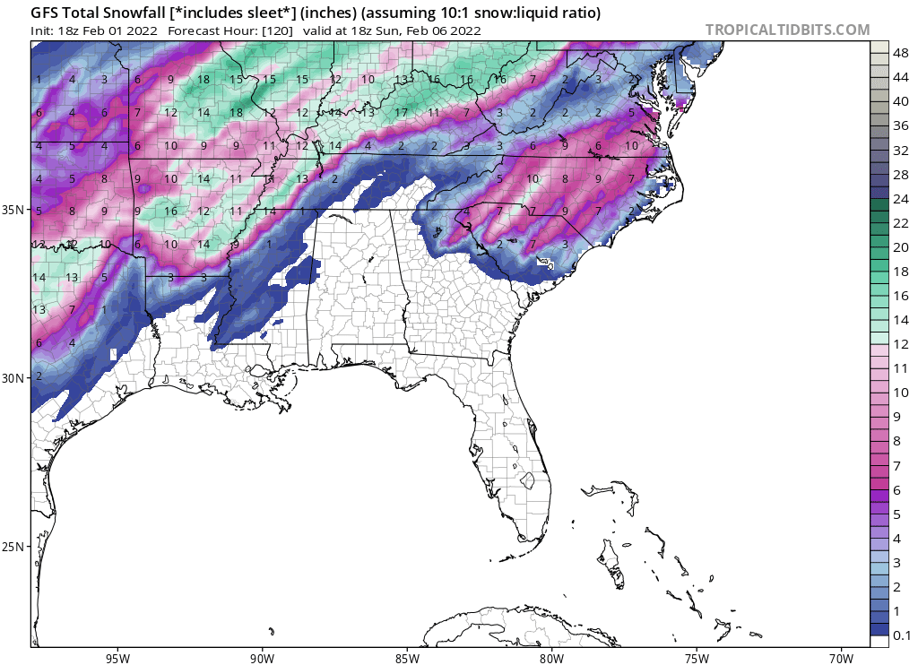
Ik we shouldn’t bc It’s a surface map and Too far out but man that’s pretty …. Put a foot on Davidson… granted a lot of Sleet probably

-
4
-
-
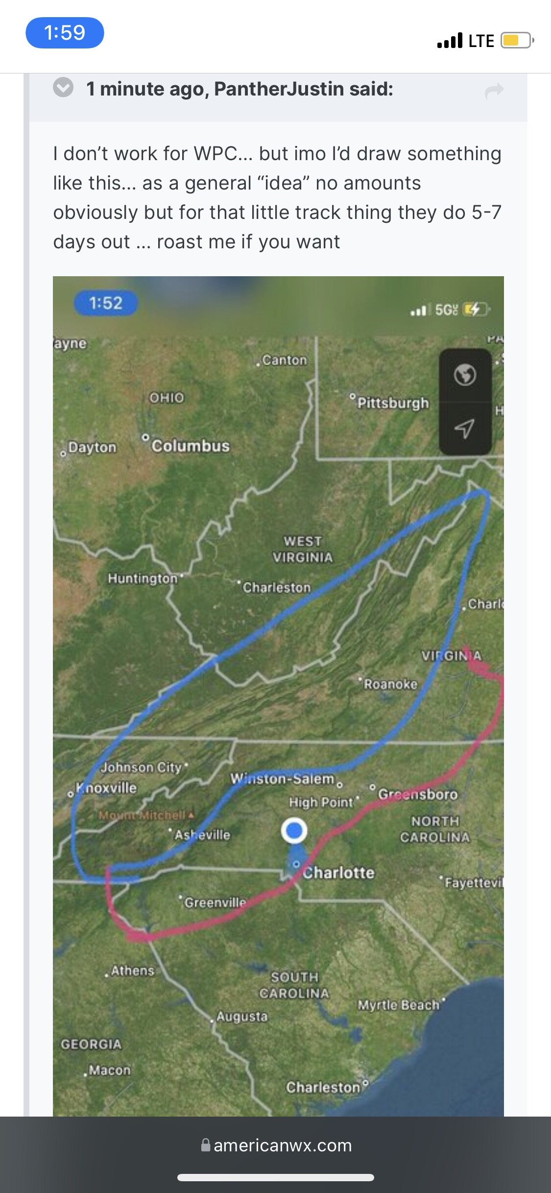
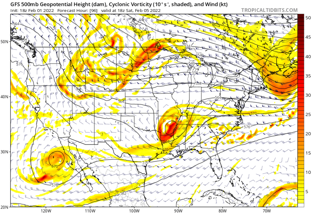 Out to the 108 now…. Open your tab for happy hour …. That 1037HP is now on MA/NY border Instead of Central Maine….. yep…. To 120 now, whole board gonna like this lmao
-
2
-
-
2 minutes ago, wncsnow said:
Weenie run for the mountains on the GFS
.thumb.png.6d7064cd1ef58553981978e886ac5a32.png)
Not to toot my own horn or anything….

-
1
-
-
13 minutes ago, burrel2 said:
Also, the 6z GFS is pretty much showing wall to wall cold. Here's the 240hr 5h anamolies.
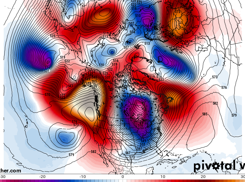
This makes me happy…. I will be at Snowshoe next Friday thru 16th I saw the OP had some Below Zero’s up there 2 days
-
4 minutes ago, burrel2 said:
I guess i'm more of an optimist but we have a legit threat inside of 6 days right now. If you're going to discount and look past marginal threats then you're going to miss out on tracking 8 out of 10 snow falls in the southeast. This threat may not work out, but it's 100% better than having no threat to follow... and every so often these threats do work out and we get a season saving 3 incher out of it.
Agreed…. I look at Long range pattern recognition like a GFS happy hour Bombing…. If GFS showed us a Valentines Blizzard tonight no one would bat an eye, but you let it show a warm up 14 out and Holy hell it’s over guys pack it in
-
2
-
1
-
-
2 minutes ago, Taylorsweather said:
... and if the long range models are correct, we begin a warmup after the 15th that lasts into March.
This isn’t towards you…. But as others have stated, we’ve been hearing for weeks now how it was gonna warm up in 3 weeks then 2 weeks then oh no 3 weeks again, rinse repeat…. I don’t believe that for a second the Long Range should always be looked at as Neutral until 10 days or so away bc of how many variables play into it
-
Also showed the GFS Mixed solution
-
3
-
-
31 minutes ago, JoshM said:
Precip moves in About six hours sooner this run. over 1 inch of freezing rain for KCLT

Which would be 1/4” max… gotta take 75% off
-
1
-
-
8 minutes ago, burrel2 said:
It's dropping 2 inches of liquid in central GA/SC. It's a great run considering the majority of guidance is on the suppressed side of things.
No I completely agree it’s still there that’s all I was saying
-
1
-
-
Well 18Z GFS Op holds atleast…. 30-32 for all Along and N/W I-85 …but eventually Verbatim turns to rain as system pulls away for ALL of NC
-

.png.26038e2d211e4cd2c9af1389ae1afc26.png)
Mid to Long Range Discussion ~ 2022
in Southeastern States
Posted
Yea I got 4.5” from that…. Never switched to FRZN