
PantherJustin
-
Posts
738 -
Joined
-
Last visited
Content Type
Profiles
Blogs
Forums
American Weather
Media Demo
Store
Gallery
Posts posted by PantherJustin
-
-
4 minutes ago, NorthHillsWx said:
Happy hour GFS is cold cold
yea would be teens Christmas Morning for NC verbatim 13 at 12z 12/25 in N subs of CLT
-
 1
1
-
-
I give this Winter a B+ …6.5” on the season Total and Had a 3.5 week span where I did nothing but track opportunities. Only 2 worked out but still. Wasn’t a very cold winter but it produced for what it was imo. I had snow in spots for 16 days and saw Snow on Snow once. See you guys next year …. Everyone be safe and start cracking open the Natty Lights and hitting the lake

-
1
-
-
14 minutes ago, NorthHillsWx said:
Yep, this immediately shot up to a bonafide threat to me when all 3 had it. Long way out obviously but should be an interesting week at least
That’s all I want…. One last Thing to track lol
-
1
-
-
2 hours ago, NorthHillsWx said:
Thing of beauty though temps are very marginal (850’s and Surface) but that’s also how we rip big dendrites and rates in the south
Gotta ride the line lol i still feel better that EURO/UKIE are on it and not just the GFS…. The fact they ALL have the storm only happened once in January that was the first storm
-
10 hours ago, WinstonSalemArlington said:
I looked at the 6Z GFS …. Poof unfortunately. But maybe there’s another Beast in there That last week of Feb/Early March has been good to Nc more than a couple times in my 30yrs
-
16 minutes ago, PackGrad05 said:
The problem is, Brad routinely posts vlogs when there is an upcoming system of any significance. In that video, he explains, in an easy to understand way, the reality of the forecast and what may or may not happen. However, people do not take the time to watch or listen and instead will believe a fantasy model they see posted. I'm sure this is super frustrating as a broadcast met.
He is trying to do his best to debunk taking those maps for face value. I think this is a great way to illustrate it.Oh no, so do i…. It’s the way he comes across now days. “I told you so” “see I told you nothing would happen” to me is all….. it’s just pointless smug imo
-
1
-
 1
1
-
-
Why is he so smug now? He used to be so cool…. Now it’s like all he wants to do is “I told you so” forecasting like he has something to prove by being First to Say something won’t happen…. Brad, You’ve got 100K followers on Twitter we know you’re reliable man don’t be like that. And as annoying as it is, for the love of god can Mets stop adding “Not a Forecast” or, “Stop Sharing These Deterministic model runs” like yea no sh*t, I’m sorry if someone is stupid enough to believe a model that says 30” of snow in Augusta GA like the storm a few weeks ago….. well that’s natural selection imo. But it’s like all but Maybe 2-3 Mets just copy and paste each other’s “nothings coming” catch phrases now. Only a few that don’t and 1 is nice enough to post on this board from CLT. I mean be unique man so you’re own thing…… Sorry rant over
-
2
-
 2
2
-
1
-
-
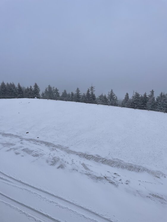
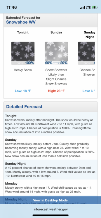
If anyone is keeping track of Accumulations, Snowshoe 24hr total I measured 3-5” range for the 24hr total…. Although I think only 2” or so Of that came from the system the rest was What I assumed to be NW Flow all day today ….sitting at 10 degrees currently …. Maybe that band back west will come thru overnight.
-
2 hours ago, Avdave said:
We actually call it Lake Effect snow back in WV and Western MD and Western PA Allegheny Mtns. Like eyewall said, its just mpisture from the Great Lakes, well primarily Erie transporting the moisture into the mtns and it gets squeezed out in the higher elevations. Thats how Snowshoe gets so much of their snows there, well natural snow it is all mainly lake effect
Yea that’s pretty awesome…. It was never a really heavy Snow but a few times it definitely picked up…. I’d say 24hr total of around 5” or so. It’s so nice too, super powdery and dry
-
45 minutes ago, Blue_Ridge_Escarpment said:
Lower than the radar beam. I’ve picked up quite a bit of accumulation here in NC before when the radar never showed anything.
Ahhh that makes sense it was just throwing me I didn’t know if it was elevation dependent since I’m at 4800’ or what. Ik Southern Piedmont/CLT Metro Climo I have ZERO clue about any mountain Climo for any state lol
-
Still snowing up here in Wv…. Can someone explain NW Flow? It’s been moderate snow for hours now but NOTHING on radar I’d say about another 1-2” today after 2” or so overnight
-
1
-
-
Hard to Tell but I’d say maybe 2” or so up here on “Country Roads” mountain… 19 and Flurries currently. Not sure what that means for you @Buddy1987 since you’re a bit further south but good luck if I’m not too late I just woke up
-
2 hours ago, CentralNC said:
you all should do pretty good up there.
Yea my point forecast said 2-4” tonight and “Around 1” tomorrow… no advisory or Anything though idk what the Criteria is for way up here though
-
7 minutes ago, psuhoffman said:
I didn’t make it up this weekend. 7 year old is sick. Curious what the snow conditions were today? Did they recover from the rain/freeze?
Hate to hear that man, hope they feel better soon! Yea it wasn’t too bad we just did tubing Today bc I also have 3 kids (9, 6, 5) and a 5 month old lol but it was actually kind of slushy until this eve probably got up in mid 30s if I had to guess, especially when the sun was out
-
1
-
-
5 hours ago, WinstonSalemArlington said:
I hope…. 29/25 Here at 4800’ SnowShoe WV…. Consistent Flizzard since about 530 … Car Topper so far atleast ….. hoping someone down there in our forum gets a surprise
-
1
-
-
29/25 Snowshoe WV…. Off n on Flizzards since about 530 even though radar hasn’t shown much, Car tops ect covered.
-
2
-
-
Pretty Decent Flizzard up here at 4500’ (SnowShoe WV) …. Doubt it but hoping for 3-6”, best of luck to all of you tonight/Tomorrow
-
2
-
-
16 minutes ago, WesternFringe said:
Looking good for mby and Augusta county in general:
...WINTER STORM WATCH IN EFFECT FROM LATE TONIGHT THROUGH SUNDAYAFTERNOON...
* WHAT...Heavy snow possible. Total snow accumulations of 3 to 6 inches is expected, with locally up to 8 inches possible.
* WHERE...Augusta and Nelson Counties, and Central Virginia Blue Ridge.
* WHEN...From late tonight through Sunday afternoon.
* IMPACTS...Plan on hazardous travel due to the potential for accumulating snow on roadways.
* ADDITIONAL DETAILS...Precipitation arrives before midnight as a rain/snow mix before becoming all snow during the overnight hours. Snow could become heavy at times Sunday morning. PRECAUTIONARY/PREPAREDNESS ACTIONS... Monitor the latest forecasts for updates on this situation. &&
Bring 50-75 miles west for us in WV (Snowshoe) maybe with that Jet Streak + Elevation we can all get into the game !
-
1
-
-
47 minutes ago, Buddy1987 said:
I don’t want to be Debbie downer but I smell a bust on this one. After seeing the 6z gfs just kinda go poof with the qpf it kinda put the nail in the coffin for me
Yea, I agree…. I will be your Neighbor till Weds. (Snowshoe WV) I was hoping you and I could pull it back west but not looking good
-
1 hour ago, Blue_Ridge_Escarpment said:
No he’s predicting torch all torch lmao
-
 1
1
-
-
Gross….. today begins just gross, we will all be sweating our ass off soon
-
23 minutes ago, wncsnow said:
The way the long range is looking, this might be the last threat of the winter for piedmont areas. Too bad its look so paltry.
Yea I gotta agree…. Im
NEVER that guy, but it’s about that time lol I hate any heat….it’s 63 here today and it’s already making me wanna begin my preparation for yet another miserable Carolina Summer. I’d give anything to live in Minneapolis or Somewhere it’s just never above 75 I’ve lived here 30 yrs and hate every minute from March-October lmao
-
2
-
-
1 minute ago, jlewis1111 said:
I dont understand why people are still chasing unicorns? Winter is over
Big dog you gonna post this in every regional forum? Go on somewhere with this BS… it’s called a hobby if ppl wanna chase A flake they’re free to do so
-
6
-
3
-
-
17 minutes ago, Sandstorm94 said:
6z

Sent from my SM-S115DL using Tapatalk
Nah… the orientation of that you can tell the 500vort placements and that it’s weak imo ….. if it was a decently Jacked System it would be SW- NE orientation…. Not being an ass just saying this is just the same garbage Sliders for now, hopefully today gives us something
-
2
-

Mid to Long Range Discussion ~ 2022
in Southeastern States
Posted
Just Posting (I would normally put in Obs but it’s dead)…. 4 miles EAST Of Mooresville in the Sticks …. Already down to 10.7 think we’re gonna crush that 6 forecast
.