IowaStorm05
-
Posts
1,486 -
Joined
-
Last visited
Content Type
Profiles
Blogs
Forums
American Weather
Media Demo
Store
Gallery
Everything posted by IowaStorm05
-

Severe Weather Threat Week...so many threats!!!
IowaStorm05 replied to weatherwiz's topic in New England
Does that mean it might fire up to the south of the extant cell? I’m just trying to monitor my mom’s drive home on route 395 and 32 she is about to drive now from Waterford. I just didn’t want her driving out in this. -
Severe Weather Threat Week...so many threats!!!
IowaStorm05 replied to weatherwiz's topic in New England
I advised my dad to take cover in west Hartford with that cell closing in there Nothing looks to be upstream for us here yet, but I expect that will easily change in a matter of minutes. -
Severe Weather Threat Week...so many threats!!!
IowaStorm05 replied to weatherwiz's topic in New England
I checked out those cams and can see the precip. -
I think that when it comes to thunderstorms, the haves and have nots line runs more of a SSW to NNE direction, where your location in terms of Western position is favored versus Eastern. This is compared to the snowfall rules, in which being further north, or simply being away from the South Coast, begins to favor you even if you are sort of close to the East coastline. Obviously, heading north is heading away from the sun that generates or supports the storms, in a general sense. Sure, the south coast is not favored compared to, say, West Hartford. But you’re still going to usually be much better off in Southbury CT or maybe even North Haven, than you would be in Providence County RI. some of you may already knew this without me saying, but I thought it was interesting enough to notate. The first small cumulus are starting to form near IJD area now.
-
Severe Weather Threat Week...so many threats!!!
IowaStorm05 replied to weatherwiz's topic in New England
RI and SE MA has never been a thunderstorm haven. Yes you do get them sometimes, but many years I remember only getting 2 good storms the whole year. I noticed a huge difference when we moved to Interior CT. I feel like, In a long term sense, the line dividing haves and have nots is drawn from Colchester CT almost directly to Woonsocket, or even Millville…and runs NNE from there but I am not as sure about where it sits in MA because I’m less familiar, except to say Braintree is a no-no. Inland RI and Inland SE MA see noticeable favor for snowfall compared to the coast. But I’m afraid that for thunderstorms, the rules are more strict and involves more of an East/West factor than the snow line does. With snow usually the south coast always is screwed, but Boston might do OK! But with thunderstorms, not so easy, those storms will be long-dead before they get anywhere near Boston. And sometimes even the south coast is favored for Tstorms compared to Providence county, if you are far enough west. I would be Southbury CT is always better than Providence Country RI for Tstorms. -
Severe Weather Threat Week...so many threats!!!
IowaStorm05 replied to weatherwiz's topic in New England
Idk but I like the HRRR in general for summer events. Isn’t that why the HRRR was made? -
Severe Weather Threat Week...so many threats!!!
IowaStorm05 replied to weatherwiz's topic in New England
Hope so. I am near IJD. I am generally far enough NW that we definitely get more Tstorm activity than the coast, but am I far enough West to get in on this today and tonight? Hard to say. Forecast this morning looked less enthusiastic than it did yesterday, which is not a shocker given this year so far. They are saying IJD will be about the dividing line between haves and have not chances today and tonight. -
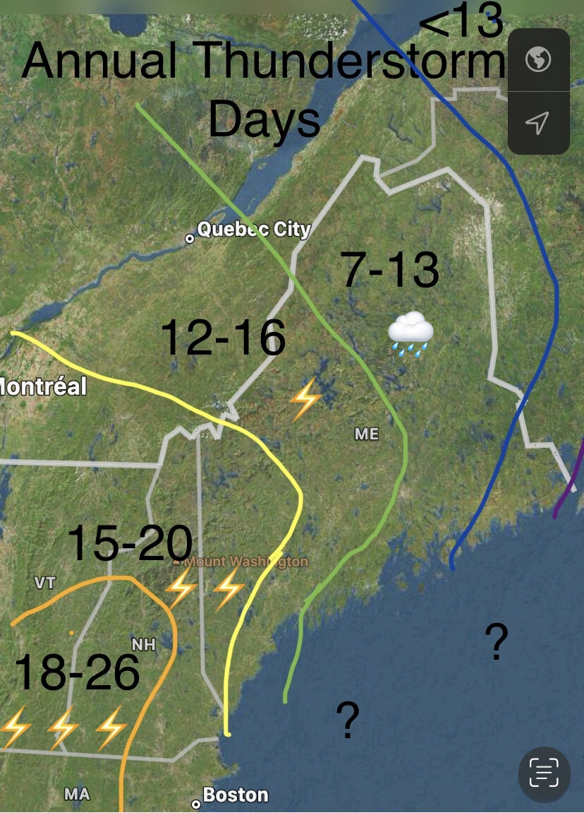
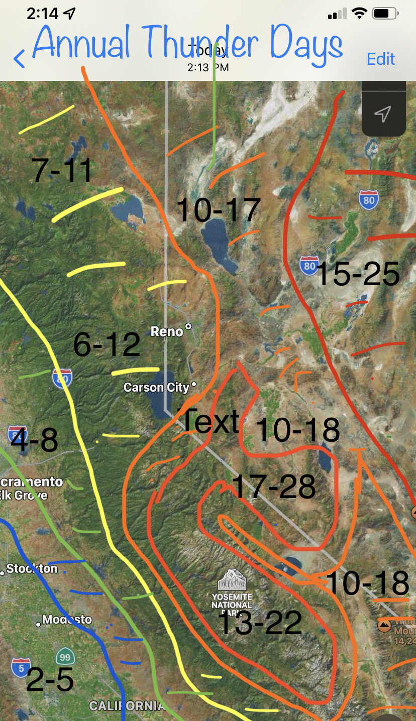
Do you like how in the middle there’s suddenly a spot that just says “TEXT”!! Like I made an error by adding a text window and just didn’t do anything with it or notice it before I wrapped up my work and sent it out. And in the southern part of the Western Sierra on the map I may have been slightly too generous. The cutoff may be more brutal but then again I’ve experienced thunderstorms in the foothills there on multiple occasions just by visiting so…
-
Severe Weather Threat Week...so many threats!!!
IowaStorm05 replied to weatherwiz's topic in New England
For Late August, after we get that massive volcano eruption with requisite chemical composition release. -
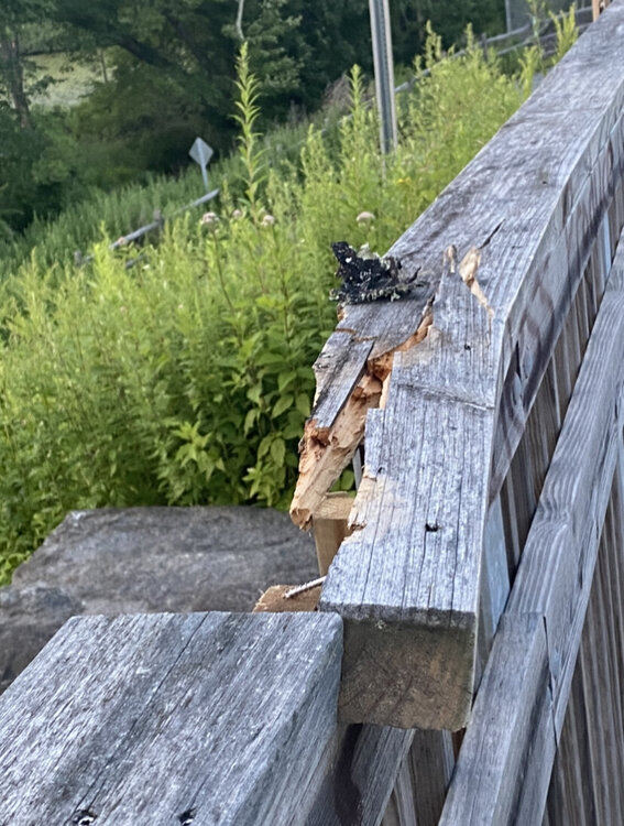
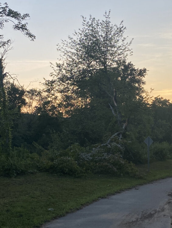
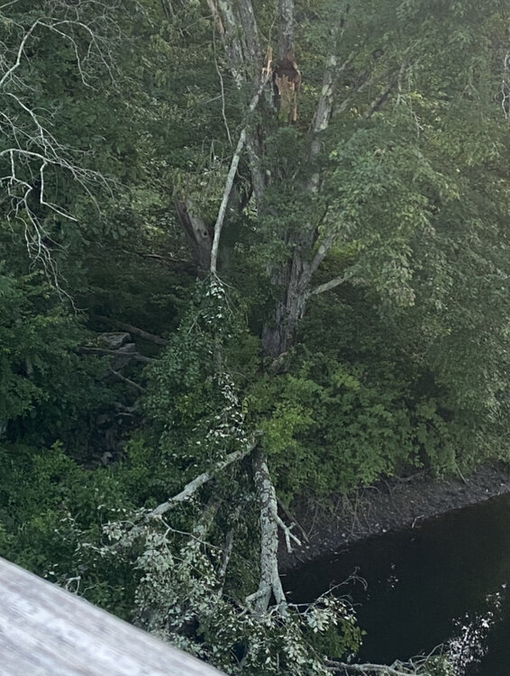
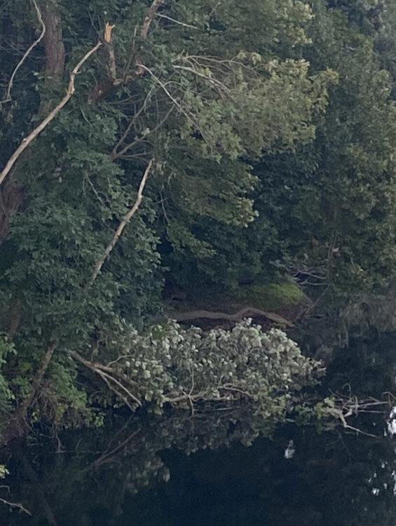
So I’m not sure which day in the last few this happened, but a passerby I encountered on the trail said it was a couple days back. A strong microburst occurred and knocked down a ton of trees on a leg of the Connecticut Greenway here in Willi. I forgot to take photos until I was almost back from the walk and so there’s much worse tree damage you don’t see. But it was pretty impressive and for all intents and purposes, this microburst trashed my favorite area. I did get something delicious there though.


-
Severe Weather Threat Week...so many threats!!!
IowaStorm05 replied to weatherwiz's topic in New England
Thank you for your Information. Having taken a look at that, and memory of other maps, I just made this: Again I know the numbers aren’t perfect, but even if they’re off by 30 per cent or something, since I didn’t live in Maine, it gives a good comparison and idea of what the ocean and latitude is doing to your thunderstorms as you go from one part of New England to another.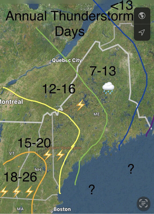
-

-
Severe Weather Threat Week...so many threats!!!
IowaStorm05 replied to weatherwiz's topic in New England
Interesting. -
Severe Weather Threat Week...so many threats!!!
IowaStorm05 replied to weatherwiz's topic in New England
It might be a bit high, but I guess one could say this is what it’s like on a good year? I can make another map after deeper research, or after critique, this one I just did based on what I know up to this point without more research. On looking twice I could see the CT coast being overestimated in this. You might not get such favorability until you’re further west than I have it. -
Severe Weather Threat Week...so many threats!!!
IowaStorm05 replied to weatherwiz's topic in New England
I do not certify this is 100 per cent accurate, especially for upstate NY, VT and NH since I don’t know those areas as well. But here you go.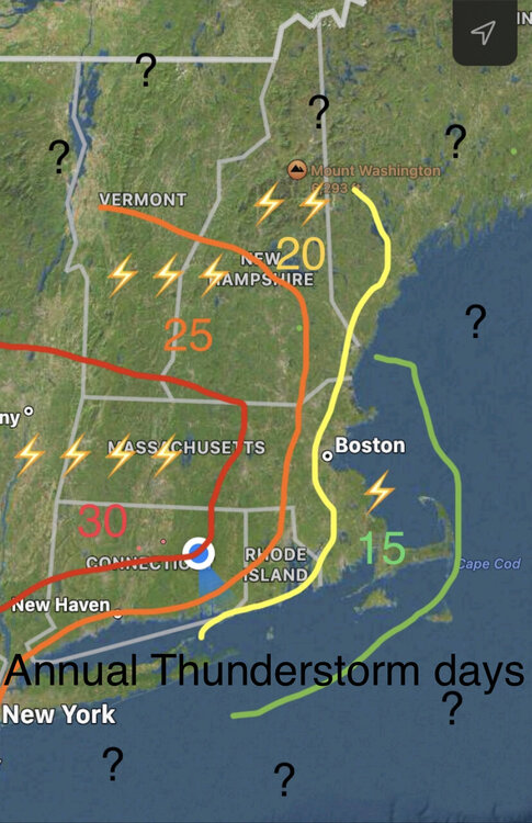
-
Severe Weather Threat Week...so many threats!!!
IowaStorm05 replied to weatherwiz's topic in New England
I had fun with the steady and badly needed rains yesterday. The late nite storms certainly did weaken didn’t they, because I never woke up. Hope for some crackling storms ahead in coming days. 2021 was a much stormier summer so far, maybe because of anomalous ocean temps? They look warmer than average now however, so it must just be the pattern. -
Severe Weather Threat Week...so many threats!!!
IowaStorm05 replied to weatherwiz's topic in New England
Here we go!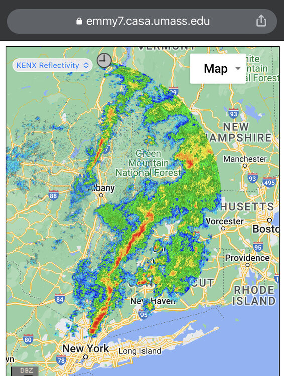
-
Severe Weather Threat Week...so many threats!!!
IowaStorm05 replied to weatherwiz's topic in New England
Is that the cells from the city? I did like it. But now it looks like it might pass us to the NW. Need something to pop up south of that stuff to Ensure it won’t miss. I don’t know if we are talking about the same thing cuz I don’t know that abbreviation and can’t find it by google. -
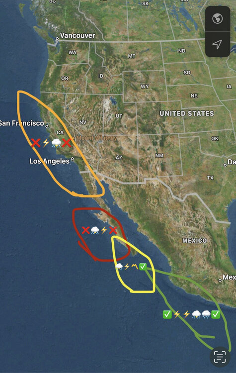
This is my MexiCali thunderstorm climate map I made. The orange and red zone only rarely get summer thunderstorms. They are cool ocean Mediterranean or desert respectively… and are generally devoid of the ingredients. But the yellow and green zones get thunderstorms in the summer at times. The yellow zone is a transition zone from desert to tropical. What exactly goes on within these zones does vary depending on microclimate, but this is a general depiction. This is mostly for coastal locations. The picture is a lot different when one heads inland anywhere along here. I had asked myself at one point “ok so you don’t get thunderstorms in the summer here, and I know why. So how far south do you need to go before it becomes tropical?” This far.
-
Has been a steady rain for most the last 60 to 90 minutes. And although radar looked paltry an hour ago, now some cells are firing up over SW CT and NYC area. They look to have a general movement towards us but only time will tell if these affect us a little later this evening. The flow was more west to east this morning and was stickier when the coastal cells failed to get us inland. This time we are more in the path of the new cells and the movement is faster which will offer more likelihood of impact, but will definitely nix significant flood risks me thinks. Enjay this activity while it lasts. You just never know when a massive volcano with requisite chemical composition will erupt and result in 6 to 12 inches of snow in late August.
-
Seems like a fairly wet day. Might not be a widespread severe event day, but maybe the kind of day where the river might get higher tonight, and there will be some claps of thunder. The QPF maps are interesting. I don’t have nearly the amount of experience looking at warm-season storm maps that I have had watching cold season storms approach with model runs etc. I noticed what looked like all-over-the-place QPF over SNE for the next 48h block of time, with the RAP and GFS looking Juiciest. But some maps looked like they had a hole or void over us. I don’t know what I am doing when looking at those though. It has been moments of light rain so far this morning, but a much stronger cell has been taunting an approach to the S coast of CT.
-
I am looking ahead to tomorrow’s stormy activity. Hope it’s a good one. Today was pretty dang warm. Still been a contrast tho so far compared to last summer where SNE practically had the climate of Northern Virginia. This summer is more typical of what I remember SNE being like albeit maybe slightly less humidity.
-
In SE CT… the clouds were starting to bubble up early this afternoon once sun came out. Then abruptly wind became onshore and all cumulus collapsed. Gonna be hard for storms to get down to the coast now.
-
Last Saturday I was freezing at work outside. It was frustrating for being mid June. I was at quasi coastal location but it’s not the White Mountains.
-
And Grass is becoming something that people are beginning to look at and reconsider “is this something we need or should be doing”? Especially in the Southwest. Obviously grass is a necessity for some layouts like sports fields. I reckon Lake Mead is virtually Las Vegas’ only source of water. I have been warning people that there is reason to believe that the lake risks falling below the lowest intake valve within several years or again at another point in the future. If this happens, many locations would have no water, save for scattered groundwater sources. Sod shan’t be a thing for peoples yards in Las Vegas.