TowsonWeather
-
Posts
849 -
Joined
-
Last visited
Content Type
Profiles
Blogs
Forums
American Weather
Media Demo
Store
Gallery
Everything posted by TowsonWeather
-
Just wanted to drop in from the Mid Atlantic forum to say congrats to all on these amazing totals and an epic storm. We got shafted yet again here in Baltimore (been a miserable decade for the North Central Maryland specifically), but I’m trying not to be TOO big of a bitter bitch about it. I’m super jealous of y’all, but I really am happy for fellow weenies that got to enjoy such a historic event.
-

2/26 - Follow-up Hopium Battlezone Storm
TowsonWeather replied to DDweatherman's topic in Mid Atlantic
"If I'm in town, lock it down. If I'm in Houston, it ain't producin'" -
Feb 22nd/23rd "There's no way..." Obs Thread
TowsonWeather replied to Maestrobjwa's topic in Mid Atlantic

-
Feb 22nd/23rd "There's no way..." Obs Thread
TowsonWeather replied to Maestrobjwa's topic in Mid Atlantic
lol Baltimore -
Feb 22nd/23rd "There's no way..." Obs Thread
TowsonWeather replied to Maestrobjwa's topic in Mid Atlantic
Fuck all in Towson. Enough to put a nice coating on stuff. One of the bigger fails in memory from a forecasting standpoint. -
Feb 22nd/23rd "There's no way..." Obs Thread
TowsonWeather replied to Maestrobjwa's topic in Mid Atlantic
I'd rather be in in Houston, tbh. -
Feb 22nd/23rd "There's no way..." Obs Thread
TowsonWeather replied to Maestrobjwa's topic in Mid Atlantic
Boo hoo. -
Feb 22nd/23rd "There's no way..." Obs Thread
TowsonWeather replied to Maestrobjwa's topic in Mid Atlantic
Color me shocked that Baltimore is getting fucked yet again. A decade of misery continues. -
Feb 22nd/23rd "There's no way..." Obs Thread
TowsonWeather replied to Maestrobjwa's topic in Mid Atlantic
I think all of us in Baltimore would not be surprised to see this kind of fuckery unfold. -
2/22-23 "There's no way..." Storm Part 2
TowsonWeather replied to Maestrobjwa's topic in Mid Atlantic

-
2/22-23 "There's no way..." Storm Part 2
TowsonWeather replied to Maestrobjwa's topic in Mid Atlantic
The Euro has budged a TON. Honestly, what models have you been watching?? The GFS basically had this solution days ago - what it’s showing now is a slightly more eastern version of the same bomb cyclone it showed from several days ago. The Euro has been gradually continuing a shift of several hundred miles and a radically different synoptic evolution that it kept insisting on long after other models had started trending to the GFS. Any attempt to portray the last several days of model output otherwise is pure gaslighting. (And I’m not saying the GFS is “right” before the storm starts - I’m not endorsing its current output verbatim at all. I’m simply stating facts about which model has clearly been DRAMATICALLY more correct about this storm’s evolution throughout this forecast cycle. That answer isn’t dependent on snow maps or snow depth, but on what has already happened with the way this system has evolved.) -
2/22-23 "There's no way..." Storm Part 2
TowsonWeather replied to Maestrobjwa's topic in Mid Atlantic
The GFS has ANNIHILATED the Euro for this storm. Let’s not be ridiculous and pretend that a 50-mile swing is somehow more meaningful than the fact that the GFS has been correct about the evolution of this storm long before the Euro stopped sending it to Bermuda and finally, grudgingly climbed aboard. -
2/22-23 "There's no way..." Storm Part 2
TowsonWeather replied to Maestrobjwa's topic in Mid Atlantic
You guys both know better. This isn’t a Miller B - not in any meaningful way. Every storm that pops a coastal isn’t a Miller B. -
2/22-23 "There's no way..." Storm Part 2
TowsonWeather replied to Maestrobjwa's topic in Mid Atlantic
Wow. Just wow. the Euro going hard in the other direction 35 hours out after trending to the GFS for the last day or two - and basically all other guidance doing the same - was not on my bingo card. -
2/22-23 "There's no way..." Storm Part 2
TowsonWeather replied to Maestrobjwa's topic in Mid Atlantic
You're fired. -
2/22-23 "There's no way..." Storm Part 2
TowsonWeather replied to Maestrobjwa's topic in Mid Atlantic
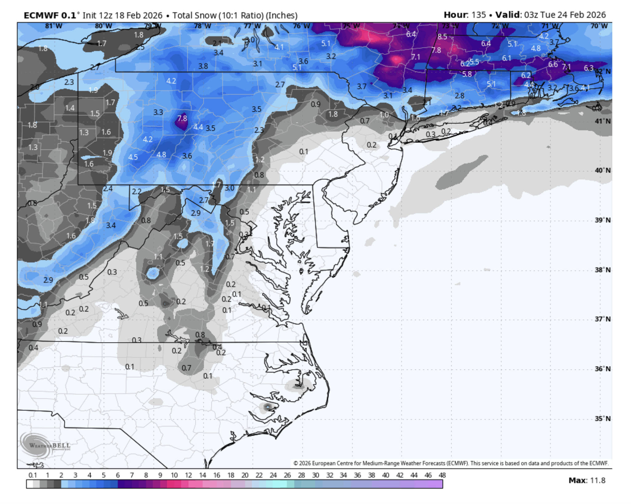
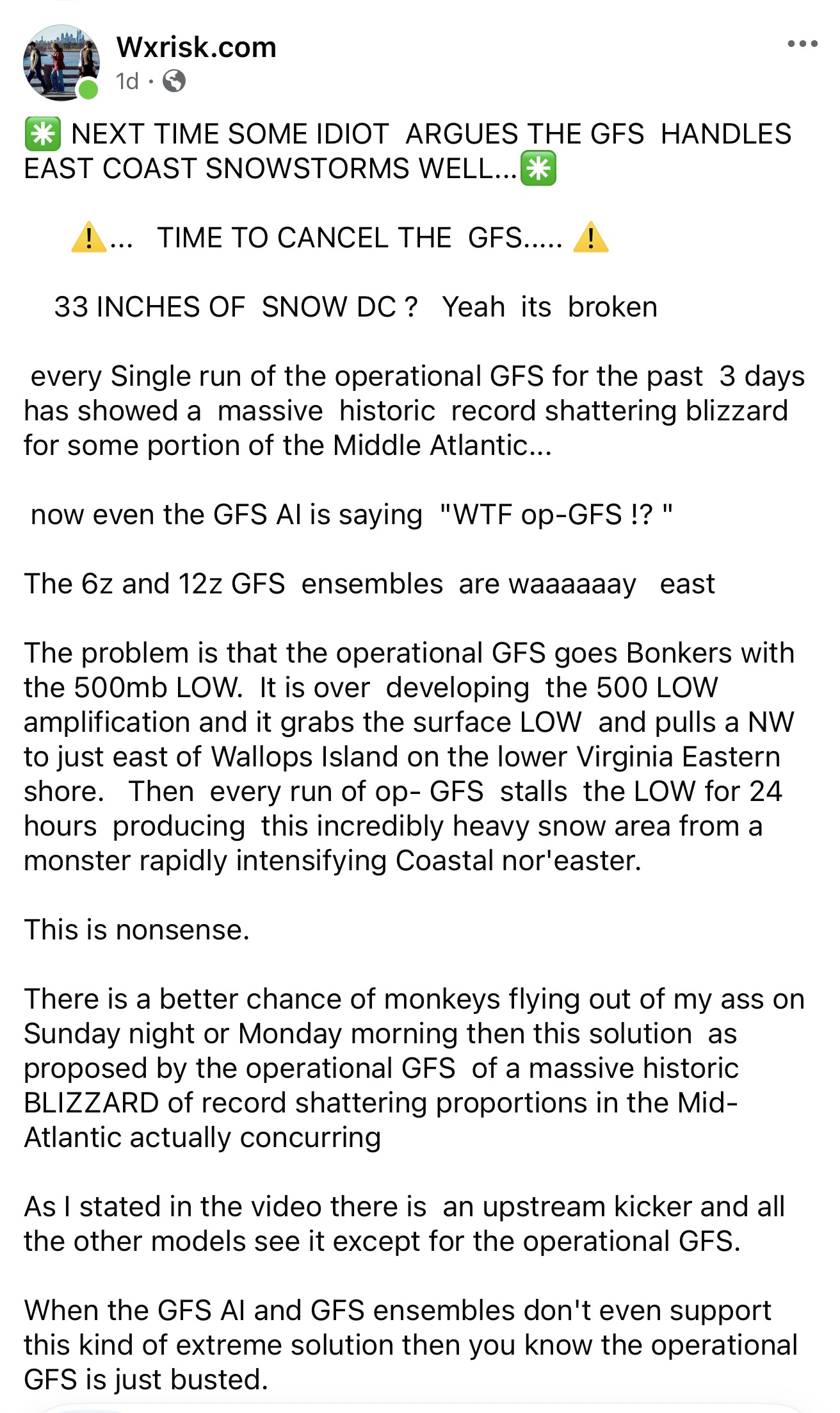
This was what he posted on his Facebook page one day ago...
-
2/22-23 "There's no way..." Storm Part 2
TowsonWeather replied to Maestrobjwa's topic in Mid Atlantic
That's the one my parents experienced like 2 weeks after moving here from South Africa in '79. No shovel. Dug out with a baking sheet and wondered wtf they'd gotten themselves into... -
2/22-23 "There's no way..." Storm Part 2
TowsonWeather replied to Maestrobjwa's topic in Mid Atlantic
-
Feb 22nd/23rd "There's no way..." Storm Thread
TowsonWeather replied to Maestrobjwa's topic in Mid Atlantic
LOL... Wut? -
Feb 22nd/23rd "There's no way..." Storm Thread
TowsonWeather replied to Maestrobjwa's topic in Mid Atlantic
For those west of the bay, I didn't love this run as much (and I say that without looking at any snow maps). But I'm not too mad. The same general idea. Gonna be a pretty tight margin between the truly epic CCB stuff and the sad peeps., wherever it ultimately ends up. The real saddies are gonna be the ones who miss the CCB and the Norlun if/when it materializes. -
Feb 22nd/23rd "There's no way..." Storm Thread
TowsonWeather replied to Maestrobjwa's topic in Mid Atlantic
42h, the theme of shallower trough and more consolidated energy remains, but more energy rounding the back-side. -
Feb 22nd/23rd "There's no way..." Storm Thread
TowsonWeather replied to Maestrobjwa's topic in Mid Atlantic
Yeah, I was on the fence at 30h, I'm in the "don't like this" camp now for 36h. Shallower trough, not quite as diggy. -
Feb 22nd/23rd "There's no way..." Storm Thread
TowsonWeather replied to Maestrobjwa's topic in Mid Atlantic
At 30h, not quite as diggy out west, but the leading vort is slower, leading to more interaction between the vorts. Heights very slightly higher. -
Feb 22nd/23rd "There's no way..." Storm Thread
TowsonWeather replied to Maestrobjwa's topic in Mid Atlantic
As subtle as they are, I would THINK they might bode well downstream? At least in theory. No point speculating, I guess, just too complex to say at this point. Could just as easily go sideways on us.