

Ed, snow and hurricane fan
-
Posts
2,133 -
Joined
-
Last visited
Content Type
Profiles
Blogs
Forums
American Weather
Media Demo
Store
Gallery
Everything posted by Ed, snow and hurricane fan
-

Major Hurricane Ida
Ed, snow and hurricane fan replied to WxWatcher007's topic in Tropical Headquarters
Because a likely major hurricane hits New Orleans in 4 days, or something seems wrong with the modeling. Thanks. -
Major Hurricane Ida
Ed, snow and hurricane fan replied to WxWatcher007's topic in Tropical Headquarters
Sunday is sooner than the models had been showing before... -
Major Hurricane Ida
Ed, snow and hurricane fan replied to WxWatcher007's topic in Tropical Headquarters
On a worst case track moving NW. I know the levees were rebuilt to be stronger and less likely to experience over-wash, which resulted in a lot of failures, but they don't need this. -
Major Hurricane Ida
Ed, snow and hurricane fan replied to WxWatcher007's topic in Tropical Headquarters
It seems to be consolidating the 850 mb center farther North, which would make sense if the MLC is strong enough to form an LLC. I don't think the Florida Panhandle is off the hook. Barely clips the W tip of Cuba, minimal land interaction. -
Major Hurricane Ida
Ed, snow and hurricane fan replied to WxWatcher007's topic in Tropical Headquarters
GFS Ensembles still spraying Mexico to the Florida Panhandle. 8 sub 984 mb hurricanes, South Texas to Florida Panhandle. NHC has 3 low level flights and a high altitude data flight tomorrow/Friday morning. Don't see that for just any old invest. -
Major Hurricane Ida
Ed, snow and hurricane fan replied to WxWatcher007's topic in Tropical Headquarters
Internet says Laura was 939. I know it isn't just the pressure, it is the gradient (1983 Alicia was named a TS w/ 1014 mb central pressure, but it was imbedded in a surface ridge), but 932mb on a 13 km model is scary. This looks like it hits the same area, although 6 days out, who knows. I do now I got several students last year from Lake Charles, because their homes were destroyed and they moved or moved in w/ relatives in Houston. They probably just finishing rebuilding the fishing and oilfield docks in Cameron. -
Major Hurricane Ida
Ed, snow and hurricane fan replied to WxWatcher007's topic in Tropical Headquarters
Bret struck the least populated county, IIRC, (Kenedy with one 'n' IIRC) on the Atlantic or Gulf Coasts. I did hear the massive King Ranch lost a lot of cattle, from wind, not surge. -
Major Hurricane Ida
Ed, snow and hurricane fan replied to WxWatcher007's topic in Tropical Headquarters
My understanding, 6Z models get least AMDAR/ACARS (upper air wind, heights and temp data) because not many airplanes flying middle of the night/early morning Americas/Western Europe. But 6Z Euro ensembles have stopped trending East. -
Major Hurricane Ida
Ed, snow and hurricane fan replied to WxWatcher007's topic in Tropical Headquarters
Deja Laura on 0Z and 6Z GFS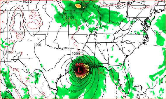
-
Major Hurricane Ida
Ed, snow and hurricane fan replied to WxWatcher007's topic in Tropical Headquarters
Judging by 18Z Euro ensembles, the trend that started closer to Veracruz than Tampico and has been coming North may be shifting from the NW Gulf (Texas) to the Northern Gulf is continuing. Bed before 0Z models, up before 5 am CDT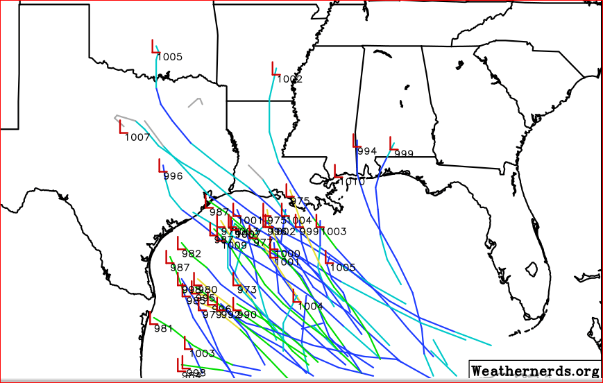
-
Major Hurricane Ida
Ed, snow and hurricane fan replied to WxWatcher007's topic in Tropical Headquarters
-
Slow trend on the Caribbean to Yucatan into the Gulf system. Has trended to Texas/Louisiana from Mexico, trend may not be done yet. Euro already East of us, but most ECENS are South. 18Z GFS, but not super fantasy range.
-
2021 Atlantic Hurricane season
Ed, snow and hurricane fan replied to StormchaserChuck!'s topic in Tropical Headquarters
The wave itself looked like nothing when NHC put the X on it for development, based on the models, but it now looks like a tropical wave the average blob watcher (like me) would notice. https://www.tropicaltidbits.com/sat/satlooper.php?region=watl&product=ir -
2021 Atlantic Hurricane season
Ed, snow and hurricane fan replied to StormchaserChuck!'s topic in Tropical Headquarters
Not quite Harvey, whose floods closed all the Houston area schools for 2 weeks, but the 18Z GFS storm just meanders after landfall with onshore flow to the N of the modeled center. If there is good news, models still seem to be trending East. -
2021 Atlantic Hurricane season
Ed, snow and hurricane fan replied to StormchaserChuck!'s topic in Tropical Headquarters
Its ensembles say Mexico, Texas, or Louisiana. Tuesday morning, from Weather Nerds. If 'the trend is my friend', this hits Tampa Bay, -
2021 Atlantic Hurricane season
Ed, snow and hurricane fan replied to StormchaserChuck!'s topic in Tropical Headquarters
12Z GFS on the border, and then, like yesterday's 12Z Euro, meanders the low around Texas, w/ greater than 10 inch storm total QPF over much of coastal Texas. I qualified the misses Texas above w/probably, in 2008 I confidently predicted a hurricane would not hit Texas. No training for arm chair amateurs, but I qualify every pseudo-prediction since then. -
2021 Atlantic Hurricane season
Ed, snow and hurricane fan replied to StormchaserChuck!'s topic in Tropical Headquarters
Decent signal on GFS and its ensembles for several days, a storm already on the NHC radar that **probably** stays South of Texas, and another Caribbean storm that may enter the Gulf and **probably doesn't** hit Mexico. (Texas to Florida). The one that probably misses Texas is at 60% already for 5 days despite currently almost a nothing burger on satellite near the Venezuela coast South of Hispaniola on model support alone. Euro has had a couple of runs of the orange into S. Texas, but most ensembles don't support that. -
2021 Atlantic Hurricane season
Ed, snow and hurricane fan replied to StormchaserChuck!'s topic in Tropical Headquarters
KTRK, ABC-13, 'chief met' (60 hour MSU green screen certificate) hyping the European run. KHOU-11 has degreed mets, but showing a golf tournament, for some odd reason. -
2021 Atlantic Hurricane season
Ed, snow and hurricane fan replied to StormchaserChuck!'s topic in Tropical Headquarters
I don't know, but I ripped up carpets and padding for my wife's cousin, and her grandparents, after Allison, almost a week no electricity and 2 weeks no school after Ike, a week no school after the Tax Day floods, 2 weeks no school after Harvey, and February, 12 or 18 hours a day rolling blackouts for 5 days during the freeze. A teacher I worked with used up all her sick days and was going unpaid because multiple burst pipes wrecked her home and she had to meet with contractors and insurance people. -
2021 Atlantic Hurricane season
Ed, snow and hurricane fan replied to StormchaserChuck!'s topic in Tropical Headquarters
Most of the ensembles are farther South, but if there is still a weenie of the year award, I nominate myself. -
2021 Atlantic Hurricane season
Ed, snow and hurricane fan replied to StormchaserChuck!'s topic in Tropical Headquarters
0Z was interesting, a storm deep in the BoC followed by another CAG storm that is the next Hurricane Ike in 13 days. Too far out in model land to worry about a second storm generated by the gyre, but enough model and ensemble agreement on the first one next weekend. Course and strength unknown, but Ida likely, and while a few Texas storms, Mexico seems heavily favored by the ensembles. But at a week, is Alabama safe? Hoping to see smart people like yconsor start posting on this. Will follow Dr. Papin closely, expert on the CAG. -
Euro is showing 40 knot plus gusts for much of Connecticut after landfall, that would mean at least some power outages.
-
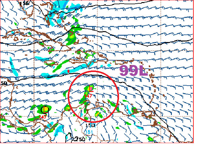
The STR that kept Grace in Mexico in full effect, Sunday-Thursday, solid sea breeze thunderstorm action every day, even had one produce a tropical funnel that reaches the ground in the NW suburbs of Houston and took down power poles. Forecast near 100F in Houston next several days. But, Gulf may get interesting next weekend, a few ECENS runs in a row. GEFS also showing some action. Per Weather Twitter, a rare August Central American Gyre is forecast to develop, and trigger one or more tropical cyclones in either/both Caribbean and East Coast.
-
2021 Atlantic Hurricane season
Ed, snow and hurricane fan replied to StormchaserChuck!'s topic in Tropical Headquarters
12Z ECENS from WeatherNerds says the Gulf is exciting next week. -
Watching the loops, it has been trying to close on eye on visible all day and coming close, but not really getting it done. Recon should be in shortly, I wonder if they will actually find a hurricane or a 55 or 60 knot storm.


