-
Posts
5,685 -
Joined
-
Last visited
Content Type
Profiles
Blogs
Forums
American Weather
Media Demo
Store
Gallery
Everything posted by csnavywx
-
Yep, weak insolation keeping this from becoming an absolute disaster here. 30.5/27.5. Lower dews will be a big concern heading towards sundown considering the steady 10-13 knots of wind.
-

Southern MD / Lower Eastern Shore weather discussion
csnavywx replied to PrinceFrederickWx's topic in Mid Atlantic
Tomorrow morning starting to look pretty nasty. Not liking the faster dewpoint drop this morning and the mid-levels get saturated again a lot faster on the latest NAM and HRRR tomorrow morning. May prove to be tough to get rid of that near-surface cold wedge. If tomorrow starts out as sleet or a sleet/fzra mix, that'll be a bad sign. -
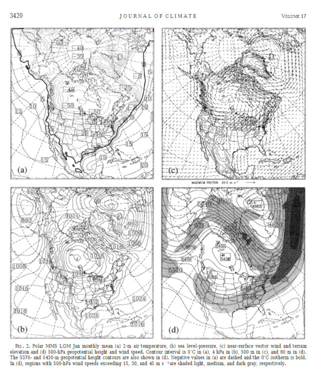
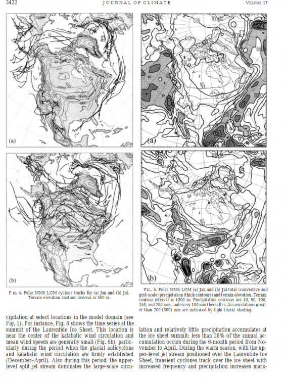
About -20C avg temp in DC in Jan. 100-150mm of liquid equivalent on average. So 3-4". Big powder bombs are a weekly event with that kind of persistent tendency for jet split. Only issue? It never really gets that warm in the summer. Maybe 40s and 50s in July on average.
-

Southern MD / Lower Eastern Shore weather discussion
csnavywx replied to PrinceFrederickWx's topic in Mid Atlantic
Solid moderate snow for a while. About 2.5" so far. Will probably end up somewhere between 3 and 4". Not too shabby. -
About 2.5" so far, moderate accumulating snow currently. Decent rates.
-
If people keep complaining, it will be 33 and tumbleweeds -- just out of spite.
-
The NAM folding to the Euro past tau 48 is literally the least surprising development ever.
-

Southern MD / Lower Eastern Shore weather discussion
csnavywx replied to PrinceFrederickWx's topic in Mid Atlantic
Both the 00 and 12z Euro runs are weenie-of-the-year material for this region. Usually the Euro doesn't flinch at this lead time, so it will be interesting to see if the other guidance comes into agreement with it over the next 12-24 hours. The setup is pretty good for us. Nearly stalled boundary, with waves riding up to provide decent bouts of isentropic upglide, slowly sinking airmass with a strong high that doesn't move off prior to the event and can feed in cold, dry air near the surface and help provide f-gen forcing aloft. Lots to like -- question is whether we'll be just cold enough for the first wave or not. -

Southern MD / Lower Eastern Shore weather discussion
csnavywx replied to PrinceFrederickWx's topic in Mid Atlantic
Nature of the beast with these super-marginal events. Really need a big arctic high to tap into to prevent that from happening. I was thinking about 2" yesterday and we ended up with slightly more than that, so can't complain too much. -

Southern MD / Lower Eastern Shore weather discussion
csnavywx replied to PrinceFrederickWx's topic in Mid Atlantic
Hope everybody enjoyed the paste job yesterday. We did respectably well. Usually do with sliders. Another shot here on Wednesday night and then again on Friday. Perhaps another after that if that big honking Arctic airmass presses down slowly, though there might be some legit mix with an airmass that shallow. -
Bit of a catch-22 going on with the 3km, and a few reasons to take issue with using it over the 12km right now. The 3km has a tendency to overdo convection in marginally unstable profiles like this, which in this case, is feeding into a latent heat bias and thus -- and likely an overamplification of the surface low. Latent heat release from convection and surface pressure falls *can* work in tandem, but there's reason for this forecaster to believe that it's overdone here -- mainly experience with the NEST in this environment. The signal for some elevated upright instability being trained in is strong enough that it wouldn't surprise me to see some weak convection and a few strikes (particularly to the south), but probably not to the ridiculous degree we see here. One thing I *do* believe is that the warm nose will be tenacious in this kind of setup. P-type and rates will be very dependent on each other near the max accumulation line. You're gonna have to smell the mixing to get the most accumulation on this one. Also, weak instability combined with intense f-gen means intense bands, and subsequently a lot of subsidence around those bands. Some folks are going to get skunked and some will get jackpotted. Nature of the beast. Basically, when there's this big of a difference between the 2 resolutions of the same NAM, take note. There's some important details that can be gleaned from it.
-
-
The 3k and 12k being different is important. 3k phases a bit better and there's a significant band of instability that is entrained ahead of the system, along with quite a bit of convection, which will definitely have an effect on precip and track placement.
-

Southern MD / Lower Eastern Shore weather discussion
csnavywx replied to PrinceFrederickWx's topic in Mid Atlantic
Nice belt of unstable air being drawn up from the Caribbean and Gulf on the latest runs. Substantial ribbon of elevated CAPE showing up that could get entrained and make things interesting. -

Southern MD / Lower Eastern Shore weather discussion
csnavywx replied to PrinceFrederickWx's topic in Mid Atlantic
That warm nose around 800-700mb showing up on the NAM is worrying me a bit about a sloppy p-type. Rain to wet concrete and a band of sleet mix in there somewhere. Will have to dig in on BUFKIT tomorrow and check it out. The Euro is a significantly better scenario for snow, where it starts in the wee hours and diabatic cooling keeps the column from warming up too much. Edit: The 06z NAM is a total weenie run for Lowershore. Plasters him with probably 10-12" of wet concrete. On a more serious note, that's a perfect slider track for SoMo and the lower shore. Last couple of runs were a hair north. Still ~48 hours to go, so no guarantees of course, but having the Euro and NAM sniffing out the exact same scenario is great stuff at this range. -
Careful using straight 10:1 here. It's more likely to be 6-8:1 or more like the consistency of paste or wet concrete.
-

Feb Long Range Discussion (Day 3 and beyond) - MERGED
csnavywx replied to WinterWxLuvr's topic in Mid Atlantic
While it would be fun to see the deep cold at the end of the run, I think I'd rather see a Para-type scenario where the PV doesn't shear out into a huge positively tilted mess and instead rolls up into a nice storm on the way out -- as the pattern concludes. The deep scouring into the Gulf on the Euro kinda puts the damper on moisture return for a while after that scenario. -

Southern MD / Lower Eastern Shore weather discussion
csnavywx replied to PrinceFrederickWx's topic in Mid Atlantic
That slider is still on the table. And the TPV can stay right there just north of the border as long as it wants. Sets us up nicely to catch any southern sliders. -

Feb Long Range Discussion (Day 3 and beyond) - MERGED
csnavywx replied to WinterWxLuvr's topic in Mid Atlantic
Notable shift in the GEFS mean and members towards the Euro on the 18Z run. -

Feb Long Range Discussion (Day 3 and beyond) - MERGED
csnavywx replied to WinterWxLuvr's topic in Mid Atlantic
I mean... if you're not honking with these LR maps, you're in the wrong business: -

Southern MD / Lower Eastern Shore weather discussion
csnavywx replied to PrinceFrederickWx's topic in Mid Atlantic
Some actual accumulations with snow tv in between a few bands. Nothing heavy or earth-shattering. That's more likely next weekend or as the big vortex starts to move out in 10d or so. -

Feb Long Range Discussion (Day 3 and beyond) - MERGED
csnavywx replied to WinterWxLuvr's topic in Mid Atlantic
This pattern has the potential to produce multiple times. The end-week wave has some explosive potential (pending timing and phasing ofc), but there's plenty of room for a follow up as the big honking vortex starts to pull away too. That's some export-quality Arctic air to work with and generate WAA/upglide on with the Gulf still open. -

Southern MD / Lower Eastern Shore weather discussion
csnavywx replied to PrinceFrederickWx's topic in Mid Atlantic
Starting to look like some light snow late tonight/early tomorrow morning and into late tomorrow afternoon is a decent bet. H5 low and H7 trough pull a decent loop-de-loop on the Nest and NMM (and the latest GFS), which will allow for some gentle lift in/near the DGZ. Throw in some leftover moisture and we could see some fluff. -

Southern MD / Lower Eastern Shore weather discussion
csnavywx replied to PrinceFrederickWx's topic in Mid Atlantic
Gonna laugh if we all end up getting more than DCA, especially you. -

Southern MD / Lower Eastern Shore weather discussion
csnavywx replied to PrinceFrederickWx's topic in Mid Atlantic
Looks like you've got about 1-2 hours left before mixing.


