Moderately Unstable
-
Posts
324 -
Joined
-
Last visited
Content Type
Profiles
Blogs
Forums
American Weather
Media Demo
Store
Gallery
Everything posted by Moderately Unstable
-
It's stronger, it's weaker, it's stronger, it's weaker, let's callll the whole thing off ba da da dum! Honestly I foresee a depression by tomorrow*. So much for Delta being a smokin' hot piece of, storm. In all sincerity this has been a very interesting storm to study and watch, from the RI into a 4 with atypical eye presentation, the sudden dramatic weakening, the wind field expansion, the models basically nailing at a 4-5 day range the track for landfall but concurrently being so awful with intensity estimates. Not a boring one to watch or forecast that much is for sure. I am hopeful/heartened by the mass evacuations from the gulf ahead of this because people were so traumatized by Laura that loss of life on this will hopefully be far reduced. At the end of the day, that's the best possible outcome here. Mets have their strong storm at sea, and people on land don't die. That is why forecasters exist at the end of the day--it is to protect the public. Well, and help stock traders know when to sell shares of Tropicana. I really feel for some of those folks. Listening to their interview segments tonight as they fled again after going through Laura was sad to listen to. I hope they get a break soon, they've definitely endured a lot. *Also sarcasm. MU
-
Hard to say. The pressure is down a couple more mbs, sat presentation better, flight level winds up. Not hard to think some of that mixes down somewhere. I think the sfmr data support 100 kts, and the flight level winds support 110, so they split the difference. MU
-
Yes we are.
-
Wow they were really early with the 11pm advisory tonight!
-
Delta must be positively glowing from all the compliments we are giving it about its figure! Clearly those at-home latent heat releasing exercise videos have been paying off! Whew, is it hot in here or is that just Delta's eye?
-
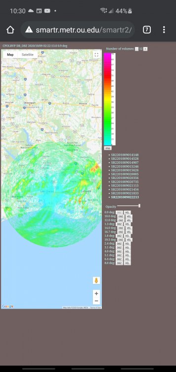
Nah, it works, they're live:
-
Wow. That's a fantastic resource, I never knew they posted the live feeds! I'm both grateful for the link and frustrated at the upcoming lack of productivity I will have at work next time there is a high risk event. Regardless, thanks!!!
-
Yes, it has been for hours in Brownsville. It's only so useful at the 248nm range. You can't see the velocities, not that that would be super helpful given the elevation you'd be at at that distance. I wish the mobile doppler coming in from OU would be integrated into the nws system so we could see it live, but I don't think that's possible. If I'm wrong and someone knows about that please feel free to chime in. Latest pressure in the eye reported by the way, 955mb.
-
Yeah, if it sounds like I am downplaying the wind threat, I apologize. I am just meaning there should be significant weakening versus what the temporary maximum intensity Delta may attain in the short-term. I would be surprised if it makes landfall as a Cat 3 or at least is able to sustain the kind of convection to mix down stronger radial winds aloft at that time. But of course you're correct. Even 60-100 mph gusts is going to be a nightmare for debris and already weakened structures, roofs, etc. Still think surge is the worst danger however due to the ever expanding size and fetch east of the core. Lol, not just you. I chimed in because it was a trend in the conversation. I agree the surge is the worst of the many impacts. I'm just saying, we are at the point in the forecast where we are looking at landfall impacts rather than the pure academic strengthening vs weakening. It's true that weakening storms don't mix winds down as well, but they do still do so. Dry air entrainment hasn't happened yet, and the models have not been perfect with this system. Not saying that won't happen, just that, the storm has defied a couple expectations already. First, shear is tracking a bit lower than forecast before, and the track is taking it over marginally warmer waters, by a degree, than previously thought, and that also does make a bit of a difference here. As you and others correctly mentioned before, a stronger initial intensity leads to a stronger final intensity, all else equal. If delta strengthens further, there's only so much time and space for the storm to weaken. It will weaken. But, it's a wind threat too. A hurricane is categorized by wind speed. It will be a hurricane. MU
-
Oof. Okay folks, this isn't a low impact event. Reading on here right now I'm getting-- half a cane, it's gonna be a shell of its former self, does anyone even LIVE in those areas? Yeah, actually they do. The models do weaken the storm near landfall. The shear on the latest guidance is actually a bit less and does not act until landfall. Ergo, no, this is not mostly a surge event. As was just posted above, and is also being covered on most news and weather outlets right now--there are PILES of debris, 2x4s with nails jutting out, piled up in lake Charles. Even if it only got 60mph sustained winds, those are going to fly around. This will be very messy. And they'll see stronger winds than that, cat 3 or not. The nws is estimating 100mph gusts. That is reasonable. The current trend is for a high cat 2, low 3 landfall, weakening or not. This will be very damaging, and emergency managers are treating it accordingly. ***This will be the second most impactful storm this season after Laura, albeit Sally was a prodigious rain producer. In 2021, 2020 will be remembered for Laura, Sally, and Delta, as standouts of a busy season. **. Perhaps Isaias will be remembered for its slow rate of weakening and interesting baroclinic interaction that led to the NE getting socked. Anyways, remember, hurricanes are not points. The rmi/rmw here is 30ish+ miles. Your center coming ashore east of Lake Charles matters dittily squat in that context. Though they won't get the right front quadrant of the eyewall--if the storm tracks perfectly along the tightly clustered guidance--they still get the eyewall. It isn't Laura. Laura was stronger, bigger, lasted longer. But in a normal year, this would be the storm of the year. The only thing here that is "good" is it is a fast mover. It won't linger too long and rainfall totals will be a "modest" 6-10". MU
-
2020 Atlantic Hurricane Season
Moderately Unstable replied to Windspeed's topic in Tropical Headquarters
Lol, well, in the shorter term, there's Invest 96E off the African coast that has a decent surface circulation and actually had some significantly organized outflow going on earlier this afternoon, but it's a little less vigorous right now with the deep convection more displaced from the center to the west due to shear. It has a couple days of ok conditions to strengthen but then may struggle. Plenty of possible places for epsilon. -
It appears based on the latest flight data, that the 12z HMON did a touch better than the 12z HWRF on pressure and wind speed estimates. In looking at the synoptic dynamics, both models suggest an ingest of dry air into the core in the 3 hours to landfall time period, with a commensurate rise in pressure and drop of wind speeds. If you buy the HMON guidance, or more generally its trends, you'd still have a cat 3 storm at landfall, barely, but with poor mixing down to the surface and an open eye to the south. That said, most guidance does probably correctly maintain a core of hurricane force winds aloft at the 850-925mb layer at an expanding radius as the storm travels inland, which could mix down in stonger precip bands and lead to hurricane force gusts in south central LA at the north end of the H warning area. The storm has turned as expected and now appears to be heading nearly due North. As it has done this, the eye has become less apparent on IR--though it did this a couple times earlier today so it is too early to say it won't improve again within the next hour. As an aside, the western part of the eye is visible on reflectivity from the KBRO radar and has been for a couple of hours now. Too far atm to say anything conclusive about what I've seen but figured I'd mention it since you can certainly see the banding at least. MU
-
Both of you are correct! More to the point, the FL winds just measured are around 15 knots higher than the most recent aircraft fix prior to this one. The SE Eyewall sonde that just came in has a pressure of 966, and was not at the center of the storm. I agree, evidence suggests that, as was forecast, the storm has re-intensified to a low cat 3. The next forecasting elements are going to be determining the timing of the turn, speed as it approaches landfall (since that will affect the impacts along the coast). In the process of typing, the eye sonde came in at 959. MU
-
Agreed, and I won't continue this topic too much since it gets off topic from Delta itself. The question is: is there a better ranking system. Some in the met community have developed and advocate for an impact based score system that factors in surge, area, speed, rainfall, wind, perhaps more. People may only digest one number, but that number doesn't have to be the sshws. They would adapt to, say, a score between 1 and 30, 30 being worst. Mets could still communicate the wind speed, and even the storm category, and bounce off the impact number to explain the specific risks of the system. Using an impact system can provide more clarity without making things harder for the public. The problem is, you don't want to under warn a cat 4 or 5 because it is small. Nevertheless, most of the risk in hurricanes is the water, not the wind. MU
-
Not sure what the state of the repair is right now for LCH, hope the team from OK is able to protect the structure if they have done any work on it already. Intensity guidance has been a bit all over the place with this system. Not bc it's inherently bad, but it's only as good as the data provided. The intensity models don't make it major because they have a low initial intensity. Low end 3 would track with the current intensification and trends. One of the best all time met profs I ever had made a point of telling us, our biggest value was being better than the models. If you as a met can't use your knowledge to deduce when models are right and wrong, you are not adding value to your company (which is your goal, and job, as a met). In other words, being a forecaster is about being better than the computers, and using the computers as tools, not believing they're omnipotent. This is well reasoned good physical thinking. If I start at pressure A and assume the most rapid possible intensification I can think of during the period I expect the storm to be in ideal conditions, what pressure do I get? 939 is definitely an outlier. Perhaps so too are the 12z intensity guidance aids, which seem a hair low, perhaps by 10 knots. Right on the money I'd say haha. Definitely seeing hints of clearing out in the eye now. I hesitate to say that with certainty because an eye has tried to form a couple of times now and been clouded over quickly but it is looking better eye wise than it has at almost any other point. Looking at the expansion of the estimated 34 kt wind field really speaks to me on the topic I've heard expressed a bit this year of enhancing the way we classify and message for hurricanes. We grade hurricanes based on wind speed. But a giant monster cat 1 that stalls, could be absolutely devastating, and a compact cat 4 that blows in at 15-18mph is certainly going to make folks in the path of the eye have a bad time, but doesn't totally capture the impact, or risk, of the event. For example here with Delta, we have a fast moving storm. The impacts from rain in particular will be much lower, and wind damage at the coast may be lower too because of a combination of speed and pre existing damage. On the other hand, the rapid speed will bring strong wind gusts further inland than a slow moving hurricane. And, all of this doesn't capture the size of the storm. I do think the nws and nhc have done well the last few years by putting out new products like extreme wind warnings, dedicated storm surge warnings etc, to granulize the impacts in a way that goes beyond the number. I still think most members of the public focus most on the cat # though. MU
-
Actually mister ghost, and supreme sock puppet overlord, it's now a whopping 9.9! Whew man, batten down the hatches mates we're all doomed ahhhhhhh *runs in a circle while entire computer terminal burns in the background*!!!!!!!!! 200 mph winds incoming! Also in advance Happy Halloween! I'm sure you must be thrilled as we approach the peak time of year to scare children! This is fun! Edit: this is sarcasm. MU
-
It is. It's just not RIing, which seems to be a trend on this thread (either the storm must ri or weaken). The windspeeds on the last pass through the eyewall are up a touch again. What you're seeing there with the 2 mb differences does not actually play a major role in terms of estimating minimum pressure. 2mb can be because your dropsonde (or plane) didn't perfectly hit the exact center of the storm. The trend overall with the pressures is they're approximately holding steady with winds perhaps up 5 knots. We've seen storms increase wind speeds before without dropping pressure. It isn't currently strengthening but it isn't weakening either. Typical non RI hurricane intensification can go like that. You inch up, then steady, then up more, then steady. Less rocket, more stairs. Edit: 2mb is statistically bordering on non significant, but 10 mb would be. Hence, if you see a big swing, assuming it gets duplicated, that's real. MU
-
I do as well. I agree with your principle--you are right, all things equal, you have a stronger initial intensity, your final intensity for a given time B is higher. But all things are not equal. We had a well formed core of a strong hurricane wilt away under moderate shear when a quasi linear convective band dessicrated the pinhole eye. Working in favor of slower lowering of intensity is a projected increase in the diameter of the eye, and larger size of the storm, which should lend a degree of stability and buffer it against some of these deleterious things. I don't disagree with your supposition that the storm gets stronger in the next 24-36 hours. Everyone agrees there. This is more a question of, let's say we have a 130mph cat 4 (being very generous here)...that is still going to weaken substantially in the 8 hours it has to traverse the suboptimal conditions. 100-110 landfall is reasonable with a 130 mph storm, and again that would be stronger than it is projected to get. We have so many analogues and examples to go off of to further that point. It isn't like the conditions are going to deteriorate with 3 hours to go before landfall. We are talking 6-12 hours. That's a lot of time for change for a hurricane. You're right. I should have said forecasted to be pristine. But, that is somewhat the point I was getting at. Gangbusters ssts and moist air but some shear and goodbye organized eye.
-
As we have already seen, with this storm directly in fact, what happens tonight has very little to do with what happens in 2 days. The nhc weakens the storm near landfall for sound meteorological reasons: the water is cold near the coast, shear increases near the coast, and perhaps dry air tries to entrain the circulation near the coast. If ALL THREE of those things hit at maximal extent, it doesn't take a PhD to recognize significant weakening would occur. Storms can rapidly intensify, AND as we saw, rapidly weaken. Ergo, don't fall into the forecasting trap of seeing something happening now and assume that it must be true later too! *If the storm is stronger at landfall, it will be due to a high rate of forward speed and having limited time for these objectively bad for the storm things to impact it*. Cold water weakens hurricanes. So does shear. So does dry air. *There is no physical mechanism near the coast that is expected to be favorable for hurricane maintenance and strength*. The degree of unfavorability and landfall intensity will come down to shear and any dry air entrainment. We know the water is marginal. If no shear or light shear is present, it will exceed the forecast intensity at landfall. If shear is moderate, or the inner circulation entrains dry air, the storm will weaken about to the degree the nhc is noting. Yesterday, we had warm ssts and modest shear and bam, cat 4 drops to cat 2 on a dime. That was in a supposedly pristine environment. Right now we are continuing to see steady strengthening. That's what we can say objectively. Not how that affects landfall. If the storm were 12 hours from landfall and strengthening, different story. MU/CD
-
Combined, the latest vdm message and current sat imagery make a compelling case that the eye is clearing out, banding has increased, and the storm is looking healthier...all point towards steady--not rapid but not nothing--intensification and with hints of a clear eye now showing on the simulated visible satellite we will probably be back at Cat 2 on the 11pm update. It should be noted that the 00z intensity guidance has been released and almost all of the models show a cat 2 peak now, even the often bullish ships. I don't totally buy that because of the underlying ocean temps and overall setup, and the frank fact that this storm doesn't need all that much to get to cat 3 strength--organizationally speaking. But the earlier post I wrote coupled with the current imagery continues to lead me to a mid grade cat 3 solution. That's not exactly GOOD news for the areas to be affected by this thing, largely the same ones still recovering from Laura. This is like having a baseball hit you when you're already opened up for surgery. Ouch. I want to quickly note that in mature steady state, strong tropical systems, we don't see a ton of lightning around the eye. That indicates one of a few things. One is and EWRC. That ain't happening here. Two is very vigorous convection--which usually correlates with a strengthening cyclone but not always. We DO have that here and that is the cause of the lightning. The same way you get lightning in your garden tstorms (side bar, hurricanes are basically a conglomeration of garden variety tstorms that basically synergistically combine to create the pressure falls and structure that become a hurricane--"garden variety" tstorms form in barotropic environments), you get in tropical systems. That is--high cloud tops, vigorous updrafts, and charge separation of the resultant cloud droplets with height. But hurricanes are wind storms. Lightning tells us about the updraft strength, not how much energy is focusing into cyclostrophic balance in the RMI. They are correlated, they are not synonymous. What has me going "ah this is probably a cat 2 again" is the symmetry I'm seeing of the eye itself now, and the fact the hunters found a closed eye. That is important in creating inertial stability and reduces the impact of short temporal scale extrinsic storm influences. On the latest T#, it is not 7.3. That is the raw number, and as the system noted, it estimates a 10 km pinwheel eye. That is incongruent with aircraft in situ measurements stating a 30 nm closed eye. The adjusted T number given is 5.0, meaning a mid range cat 2 storm, using one particular computer algorithms estimating technique. A T 7.3 corresponds to cat 5 winds. This ain't that. I buy T 5.0. MU
-
Sock puppet eh. What show do I star in? I can't wait for my reviews! Based on the last couple of days, RI may be relative. What was seen a couple of days ago was voracious and unusual. We should, based on the recent imagery coming in, expect I. The guidance says we should see more intensity, the microwave and IR imagery is improving, the above post referenced by Windspeed and JasonOH was in particular an "oh, well then", moment. I am taking the same approach as the NHC likely is about to right now, in not jumping the gun and rapidly changing their thinking. Hours back, folks were saying, it may be a 1! What a joke! etc. We can't swing 1-4-1-ts-4-5!. I still think a cat 3 peak is the most likely scenario. Big cat 3, maybe upper end cat 3, with extensive surge impact. But right now I go mid cat 3. Outflow does look a lot better, and historical context suggests good outflow is key in terms of sustaining and maintaining a clean core, which appears, again above, to be developing. To the two earlier posters who said the nice things/welcomed me--thank you :). It is nice to have a place to discuss weather without being looked at as though I have three heads. MU/CD
-
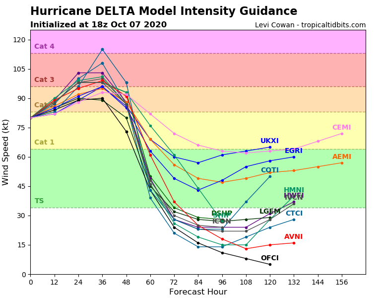
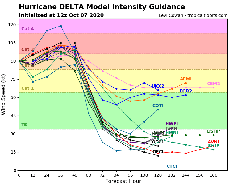
Yes, I agree. The 18z intensity guidance just came out and it has again trended down--slightly, and mostly due to lower initial intensity. Most of the models made the storm a cat 3 in the 12z runs, now more keep it high end cat 2 with slower strengthening, or low-end cat 3. You can see from the spread that we should know in about 12 hours whether to go with the bullish or conservative guidance, which makes the difference between mid-2 and mid-3 by the end of the period in which strengthening is possible. The models are capturing the potential--the energy available--but not necessarily what we are actually seeing. All the guidance says, the storm should be strengthening now. The current sat presentation is as it has been--cycles of incredibly intense convection, presently that's expanding in area again, but no clearing of the eye. I'm particularly monitoring the southeast flank of the storm which appears to be currently getting eroded a bit. That appears to be an outflow interaction of some kind from another disturbance. What I will say, independent of category, is that the storm IS growing, as expected. So, from an impacts standpoint for surge, that is tracking towards "verify", in that it will be quite substantial. It may also increase the power outage numbers--most of the area in the track cone is damaged from earlier storms, notably Laura, but also Sally and Marco, and thus that large area of even TS winds will cause a lot of misery for a lot of folks. The HMON and HWRF are a bit high, but they, and the other 12z runs of things, show more strengthening perhaps as the storm begins to curve. My guess is they are estimating a more favorable shear vector after the turn. The most recent pass through by the aircraft does have the pressure down a few mb and winds have increased by around 8 knots. CD/MU
-
Not that the euro is a bad model to use, but in the short-range, using high resolution models, particularly hurricane specific models, will yield more useful predictions. There's a plethora of fine-grained data to use right now from the statistical intensity guidance being put out to ensembles. If you aren't already using tropical tidbits or a similar resource, that is a good place to start. Any one operational run of a global model isn't helpful in this type of situation. Weather behaves in a "chaotic" manner as time goes further along. A slight error in the initial intensity estimate, the wind field, ocean temp, ocean stratification, wind patterns elsewhere that will later affect the hurricane--all produce exponentially increasing levels of error as you propagate out in time. Step one--look at the physics. Where is the storm going to encounter warm SSTs and low shear? Answer: now. Once you know that, you know where the storm should strengthen or maintain intensity. So, it should be strengthening now, if it's going to do so, as it has the right ingredients. Find model guidance that tracks with reality. Just because a model says something will happen, does not mean it will. Particularly with deep systems like hurricanes, a "small" error of 10-15 mb pressure, translates to some big differences in potential intensity! Using ensembles and clustered guidance for track and intensity accounts for this uncertainty and is statistically going to provide you with more accurate data. Step 1a, really, is at this point, look at the data from the hurricane hunters, along with sst maps, and current and 1-2 day progs for sfc, 700, 500 mb, 300 mb, 200 mb. In the shorter term, to be blunt, we have to first see if the strengthening off the coast verifies. For much of this storm's life, we've had vigorous (atypically) convection with very cold (e.g., high) cloud tops, but it has struggled to actually tap into the energy available to create a well formed eye wall translate all that heat into momentum and do so with a degree of inertial stability. The thing isn't near its MPI right now. The hurricane hunters are currently flying through the storm, and I haven't seen evidence *yet* of re-strengthening. That doesn't mean it won't happen, but, the storm is *supposed* to be in a good environment and for it to bomb back out, it needs to do so in the near future. It doesn't have a *ton* of time at the speed it is going in this optimal environment to actually gain more strength--about 36-40 hours. What I found sort of interesting looking at recent satellite imagery is that right after the storm left the coast, it tried to redevelop an eye--an actual eye. Then the insanely vigorous convection shot up again and sort of disrupted that flow state. I'm starting to wonder if perhaps the vigor of the updrafts is actually hurting the storm rather than helping it. That's not a normal conclusion you think of with hurricanes but I've seen this happen twice now with Delta and in both cases for Delta the intense convection weakened the storm and interfered with the structure of the eye. It appears now that the eye is again trying to reform next to rather than under the deep convection, which it has done a few times (that in particular is not atypical for hurricanes, the center regularly reforms adjacent to the most vigorous convection). The *outer banding structure is looking healthier now*, so if Delta keeps the convection *in* the eye down, it will likely bomb back out. But it has struggled with that so far. My conclusion at the moment is, wait to decide on what model guidance I want to go with until I get more data on the storms trends in the next few hours. I also want to see if the shear relaxes a bit more, as is forecast. Final edit thought--looking at the sat, I'm thinking mid level easterly shear which has been a factor for a lot of the storms life, could be tilting these vigorous eye wall updrafts, same as you'd see in a severe weather setup, and that tilt is then causing the tops of the clouds to perhaps overshoot and overlay the eye. CD/MU
-
Well, okay, let's not get carried away. If you look at the earlier missions into delta, not every single pass through the eye results in the same measurement of estimated minimum pressure. Dropsondes are used to measure the low level environment. Past missions on various canes show weaker winds in certain pass throughs. It is obviously weaker, pressure is up, and I think folks on here have done well identifying why (mid layer moderate shear). If you look at that shear it's a testament to the ocean temps the storm has been so explosive today and held together-ish. Also, I agree with what some have said: this storm isn't over yet. Yeah, it is weaker now. I could see a drop down to cat 3 status with this update (higher pressure, worse sat presentation, lower aircraft and sfmr winds), or if they're being aggressive, high cat 2, but they aren't going to drop it to a 1. They probably won't drop it to a 2 either. If it continues to weaken they'd go to 2 on the 2am advisory. Continuity, also something someone mentioned. Think about the optics of them going down to cat 2, people in Cancun relax, then, shear drops and it intensifies before landfall and they do a late stage upgrade to cat 4. That's not a good thing and why continuity exists. The ocean is warm, storm is strong, it isn't going away. Edit--they dropped it to 130 so still cat 4, but a big 3-hour drop. Generous. Second edit: yeah okay they also said it was generous. Lol.
-
http://www.atmos.millersville.edu/~adecaria/ESCI344/esci344_lesson10_TC_structure.pdf (1) Thank you :). 2) If you buy almost any of the current guidance, I haven't looked at a couple of "proprietary" hurricane models yet...you expect a larger hurricane with a bigger wind field, and perhaps, no, you don't get the cat 5 peak. I don't bet against cat 4's over warm ocean's though. Using a wind speed equation from the above, Vmax=A sqrt(ambient pressure-minimum central pressure), with A here as, per the above, 6.3--- Vmax= 6.3*sqrt( 1016mb- 956mb) = 48.79 m/s --> *2.23 mph / m/s--> 109.162 mph. That seems low (although to be blunt if you told me 956mb, gave me a sat image of Delta right now and said it's a 110-115mph storm I'd say I believe you). Regardless, I did something wrong in that analysis which is why my reply took so long. Either I chose a bad value for A, or I incorrectly estimated the ambient pressure outside of the storm. I considered that pa is the unit of pressure vis a vis SI units, so I tried that conversion first but that was, well, let's just say that didn't work.That however is just one empirical equation so it doesn't mean all that much. I spent the last thirty minutes reading through the above link, see btm pg 11-13 for the whole lack of currently visible eye thing (but I'm still digesting it). Specific things I wanted to pull out: -The intensity of the cyclone can [] react rapidly to fluctuations in diabatic and latent heating, as well as fluctuations in vertically integrated divergence. -At some distance near the center of the vortex, the dissipation of angular momentum can no longer keep up with [] horizontal advection. This leads to a horizontal convergence of angular momentum. --> This horizontal convergence of angular momentum leads to an increase in the winds above the value that the pressure gradient can support (i.e., they are super-gradient). --> The super-gradient winds develop a radially outward component, since the pressure gradient cannot supply the required centripetal acceleration. -->The consequences of this are (see figure): ◼ There is radial convergence at distances outside of the radius of maximum winds. ◼ There is radial divergence at distances inside the radius of maximum winds. -- As the air subsides, the resultant compressional warming actually works against subsidence (through buoyancy).********* All that is needed in order to keep the eye relatively clear is enough subsidence to balance the buoyancy.******** Thus, in the steady state, there doesn’t have to be strong subsidence in the eye in order to maintain the eye.****** The maintenance of the eyewall is a balance between the horizontal and vertical advection of angular momentum. The radius of the eye can expand or contract depending on this balance. ********* So, taken together, there is not enough subsidence to balance the buoyancy being seen, or, in english, the SSTs are very warm, and supporting vigorous convection already (which we noted above with the -80-90 C cloud tops and tons of lightning). So, that in itself isn't necessarily an indicator of a lack of strength, it indicates extremely vigorous convection and at least cursorily that compressional warming is hindering sinking motion in a piece of the eye in a manner that isn't *weakening* the storm but is precluding the eye from clearing out (if anyone who wants to correct me has a better response to this please feel free to chime in). What is more of an indicator is symmetry--which we already know--since that's basically telling us about the overall shear situation and organization of the system. There were a bunch of other things I got out of the paper/lecture I was just reviewing but that is the most salient part. One final piece I did already know but the paper noted as well, and I do actually remember with a couple intense storms in the gulf the last couple of years is that having good upper level outflow becomes important to get truly monster-level cat 5 type dynamics, usually with a "dual jet" outflow. 3) The biggest impact of Gamma's remnants is that the airmass ahead of Delta is wet. Minimal fujiwhara effect, minimal impact to shear. Several earlier season gulf storms suffered when running into dry air, including Gamma. Gamma's remnants create a moist airmass aloft out ahead of Delta so it is unlikely to entrain any dry air before landfall (that's my guess). So, the best way to interpret Gamma, I think, is that it will not HURT Delta. The best way to figure out what will happen is to look at the analogs, but, I have always been horrible at analoguing so I'm currently looking through the data trying to find a good comparison. 4) The latest hurricane hunter aircraft just entered the storm and is now making observations which you can follow in real time and I'm sure we'll start seeing the posts for that on here soon. I look forward to eating crow at being wrong on half of whatever I've just said. I will say, in the span of me writing my first post, and this one, and editing this one, the storm has regained more symmetry and I'm seeing more pockets of 85-90 c tops (which to be clear, you don't see a lot even on cat 4s or 5s...that's insanely cold). I'm sure those eyewall adjacent cells are hot towers.