Moderately Unstable
-
Posts
324 -
Joined
-
Last visited
Content Type
Profiles
Blogs
Forums
American Weather
Media Demo
Store
Gallery
Everything posted by Moderately Unstable
-
I think that's due to low level dry air that worked in. You won't see it necessarily on the sat. Sat shows cloud temps, e.g., tops. Not the base or depth. Looking through the vil values at KMOB, it looks like those clouds don't have much low level moisture. This happens with winter storms too...snow starts falling, air is dry, takes time to saturate the air and get that precip to reach the surface. The clouds on the backside of this storm are definitely convective--they aren't just a cold artifact, so, they still pack some likely potent and poorly resolved winds. One of the local nws sites tweeted out something about dry air entrainment a couple hours ago when prognosticating a high gust factor so I think that's what's being seen there. May also explain some of the wave patterns. To a similar degree--although the storm is over land, two things can help maintain strength in addition to the upper level divergence. First a portion of inflow has remained over the gulf the last several hours and is visible on satellite feeding into the storm's core. Second, the low levels of the atmosphere if sufficiently humid can near the coast act in a manner similar to shallow water regions and result in a longer term maintenance of strength. The third thing at play here continues to be baroclinic influence. This is a warm core system being aided by what are basically cold core dynamics. Unusual, but not unprecedented. MU
-
The slower phasing of the mid latitude low than forecast seems to have ended up reducing shear and instead helped to enhance upper level divergence. This baroclinic interaction seems to be responsible for why we saw such rapid strengthening today despite marginal water temps. Looking at the totality of data coming in, I think this will be post mortem upgraded to cat 3. I'm in disbelief. It has held together well as it travels inland as well. It's weakening but frankly not as fast as you'd perhaps think. It's still firing -80 degree convection in a symmetrical fashion OVER LAND. It made landfall 4 hours ago. Doesn't it know it's not over an ocean??? Talk about exceeding expectations. Who had Cat 3 landfalling end of October hurricane in NOLA on their 2020 bingo card? MU
-
It's a closed circulation. There will be winds on the backside, there sure were for Isaias and I have video of it. They won't show on radar. Radar relies on bouncing off water droplets and inferring vectors based on the returns. No rain, no return velocities. Does not mean there are not winds in the trunk. Weaker bc subtracting the speed of the storm instead of adding & no mix down from aloft. 40-60 is likely inland on back. MU
-
So, basically it has to do with the convective structure of the storm. From the eye, air twists upwards and circulates outwards in a divergent pattern. Surrounding concentric rings of convection form because certain regions concentrate momentum and energy. Imagine a bunch of big vertically oriented ovals. Air rises, is ejected outwards, and then descends further away from the center of circulation. This creates alternating regions of rising and sinking air motion. The stronger the storm, the more well organized, curved, and structured, these bands get. MU
-
Do you know which way that cam faces? I've been trying to figure that out. I'm at the office right now and can't tune into the weather channel to see what they're reporting. Also, aggregation of the now-occurring damage see twitter nws nola: https://twitter.com/nwsneworleans?fbclid=IwAR0y3rGWbG_B7bN8U77WgY7I0HyFqCrqvXLUqDy84gOq8cgNjfEyWncIctY
-
Holy ****.
-
NHC director is currently live on facebook giving an update.
-
Latest vdm reported "eyewall degrading rapidly". MU
-
Sigh. I could continue this conversation, but I don't feel like it's productive and helping anyone so I won't. The storm is about to make landfall and I want to see what the hhunters just found and watch what happens. We can talk about this later. I don't pretend to know more than the nhc, and I don't question their scientists who have dedicated their lives to studying hurricanes. The 5pm advisory should be out any second along with a new vdm. We can chat about 5mph differences and rounding and what should or shouldn't be done another time. MU
-
Not what I meant. They are usually rounded UP. Not down. Not cutoff at 2.5mph and if it's a 112 major they'd say it was 110. They'd say 115 cat 3 if winds support 112. MU
-
No. They said it would be upgraded if conditions indicated it should be. Wind speeds are not rounded. Anemometers are accurate, particularly those employed by the nhc, who are not using backyard anemometers from their planes and sondes to measure things. I agree this is non political. You conveniently cut off my message which was quoting a troll that quoted themselves to contradict themselves trying to start a political argument on a weather forum. *I* am not talking about politics. MU
-
True. I'm familiar with Colorado's situation since I had to turn back on a 14er out there in Sept due to smoke. Yes, 2020 is the year of Murphy. I live in Philly. They just announced a curfew for the city tonight so I have to leave work early to make sure I get home in time. At this point I would issue an extreme wind warning. It's on the doorstep of the city. It ain't dying now. Landfall is coming soon. MU
-
Ok that makes more sense. I mean, idk, I still wouldn't do that myself. If I strongly expected a tornado to go over my rental house while chasing tornadoes, I might consider a different house and *chase* the bad weather rather than find myself homeless mid season. True. You're right, there could be a problem with them. I was more stating, this storm's characteristics don't seem like they will place a true strain on the system to a degree that defects would cause problems. The main stress force on a levee is water, not wind. So, with a strong wind event but moderate surge (compared with a catastrophic event), I don't see the levee system failing even if it had an imperfection. Something could go wrong. But, I feel like that's more probable if the storm was going to be a 24+ hour event. I feel like this isn't the event that dooms the levees. It's a wind event that travels far inland. MU
-
I'm not sure...do people buy houses intending to be hit directly by hurricanes? 0.o ...Seems like a bad option for gaining equity! Definitely still strengthening. Holy cow. Eh, I don't think it will. They've been in the path MANY times this season. They still remember Katrina. They are very very prepared. You're never going to get 100% of the population to prepare but all in all, I believe in the population of NOLA and their EMS to have done the right prep work. This is a fast moving storm. You don't have saturated ground + strong winds, you've got strong winds. And they aren't escaping those winds. This thing is an express to New Orleans. // -Marginal case for cat 3. If they get hit with a fast moving low end cat 3, next time a slow moving, high grade cat 3 hits them...the citizenry will pay less attention. Remember the goal here is to inform the public, protect property, and save lives. That's already being done. Case exists for 110mph. Case does, technically, exist for 115mph. BUT, the environment close to shore is meh. The winds above ground will mix down to make it a major if it continues to strengthen. Also, messaging is better to say consistent cat 2 then say oh it's a cat 3 oh now back to cat 2 oh now this. If it looks extreme near shore, yeah, they'll bump it up. But needlessly upgrading could make many people want to hit the road and run away...which would be bad at this point!!! Scientifically you could make the case for Cat 3, but as I've explained before in other threads, that isn't the entire picture. If things continue along the current trend, they won't have a choice but to bump it up. -Extreme wind warning issuance would be made close to landfall. It's not on shore yet. It's got a couple hours to go. People know what is about to happen. You do NOT want to overwarn people. If you "waste" your warnings for a fast moving cat 2/3, how do you convince people to do more for a cat 5? How about a cat 1 that moves at 5mph with a giant wind field? People pay attention to the category number and extreme wind warnings are high-end warnings. The NHC won't underplay the forecast if the data support cat 3, but they won't overplay it if it's marginal. Maybe 110 at 4pm, if they feel it's solid they could bump it to 115 at 4pm or wait until 5pm. The big thing with hurricane forecasting and messaging is consistency. It's jarring to go up and down and up and down hour by hour, minute by minute. What would this forum say if they went to 115, then, at 5pm, it fell apart? What would citizens of NOLA say? I mean, I don't think it will--but the moment this thing looks a tiny bit worse, people on here will go "ah it's over!" "so much for that", "it'll be lucky to maintain tropical storm strength". In other words--moderation, folks. Frankly right now it's sitting on the border where 115 is plausible and reasonable. I'm not sure what I would do if I were the NHC, but I'm glad I don't have to be the one to make the call. -This is not as strong as Hurricane Laura was at landfall. It is not the strongest storm of the season. It's well organized though. -The levees will be fine. They are designed to handle a slow moving monster. They'll handle a fast moving mostly wind event perfectly well. Surge is a function of storm speed, storm size, wind speed and duration of time at that wind speed. And this isn't going to produce 30-40" of rain either. -I hope that people in the NOLA metro are preparing to take shelter. A 2x4 at 115 mph hurts. I assume they are, per my above comments. But, still. MU
-
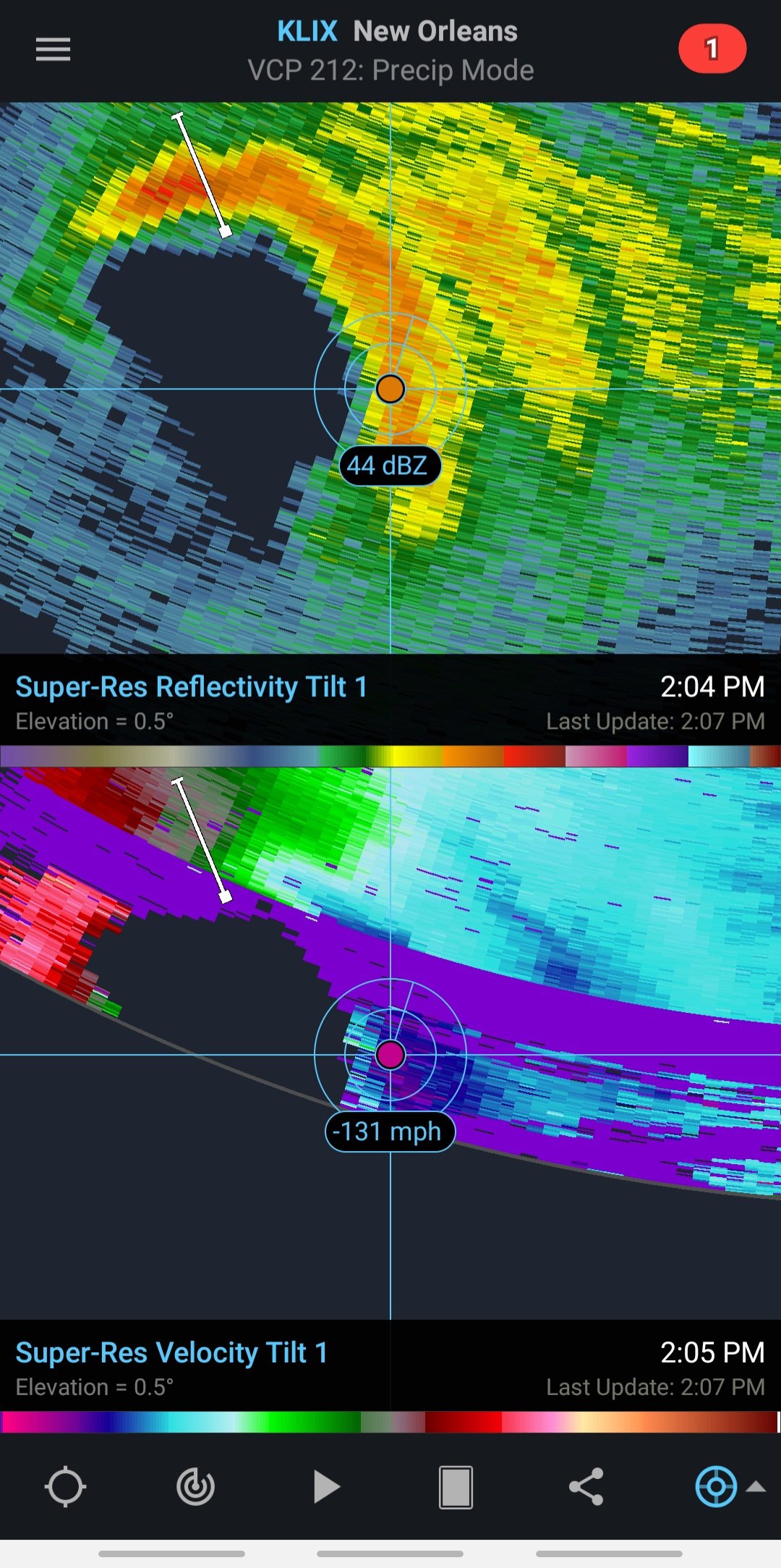
Last post for now from me but if you have Radar Scope, the velocity imagery for the eyewall is now starting to show on radar. Being mindful of range folding (the purple you see in the image in the ring shape is range folding) and beam height, the right front quadrant shows a broad area of 115mph winds with a small pocket maxing at 131mph probably in a mesovortex. Beam height at that distance is 24k feet, lol, so that ain't mixing to the surface . But, that's still an impressive measurement and is above what I believe delta was at on its approach for the same approximate height. Indicates the system is well organized and not falling apart. MU

-
Aircraft data: 975 mb (down 2) 93kt wind btm 150m in SEeyewall. That would imply probably 97kt winds in NE eyewall. Peak FL winds of 102 knots, which likely supports a surface intensity of 90kts. Eye is *open* to the NW-W, and is 24miles in diameter. MU
-
Katrina was slower, much much MUCH bigger, and New Orleans didn't have the protection system they have now. After Katrina they made major design changes to all kinds of things. This is a strong hurricane hitting a major city, it will do damage. But it will do less damage than Katrina...and such would be true even if they were the same in every way...size speed strength, because NOLA has now redesigned their city to better withstand a Katrina. The similarity is simply that it's another hurricane poised to directly impact the city. That's not to minimize it, just, Katrinas and Harveys.. those are a really rare type of event. MU
-
Collectively, wow. I agree, NE eyewall pass will be impressive. Though the winds there that got sampled are still getting a boost from the fast forward speed of the storm (note the direction of storm motion compared to the wind barbs). Also want to know the surface pressure. Impressive. But, no storm jumps 25mph in 3 hours. It's landfalling in 6. Does anyone have an analog for that big of a jump that fast over eh waters? I don't! Remember that Cat 2 is still impressive here given the water temps, time of year, that none of the guidance except the extreme high end projected such an intense system. I think the consensus on the forum right now is that it's at cat 2 strength. It's going to run out of ocean before it can hit cat 3, but honestly even I am surprised how well this is holding together and strengthening so close to landfall. MU
-
I try not to focus on minute-by-minute forecast changes based on how the storm looks at any given moment. I said this yesterday when I said I thought this would become a cat 2, and I'll say it now: I do not see dry air entrainment. The radar from klix shows a well organized system with several well formed curved bands. Better organized than some stronger wind-speed storms earlier in the season. Right now the eye is starting to show again. A hurricane is a well organized collection of thunderstorms. They pulse. Look at trends over the course of a few hours and don't get too bogged down by looking one way now another way now. Landfall intensity I think will be a function of shear. So far, shear has stayed low. 81-84 in this environment for water temps is fine for maintenance with low shear. Right now the storm is still over slightly warmer waters. I am guessing that that is what the 06z dynamical models picked up on because the structure of the system in said models depicted a relatively symmetrical storm, which implies low shear, and we do still see that now. The thing isn't on land yet and it will inevitably look different in 2 hours than it does now. For that reason, don't count the storm out without a clear eye, and don't assume if an eye clears now that it means RI. It's still strengthening right now, it will level out at some point close to landfall. I still say Cat 2 is likely as a peak intensity--low end Cat 2. Good upper divergence, low shear, not doom level water temps. Marginal 100mph storm. This is a good example of the difference between fast uniform flow and strong shear. Overall the storm is very short on time to change much. It isn't going to become a cat 3 and it isn't going to collapse into a tropical storm. What IS important to note is that a strengthening or steady state tropical system does mix down winds easier. So there's a difference between a weakening 100mph storm and a strengthening 90mph storm. The strengthening 90mph does more overall damage (potentially, I'm postulating here so if anyone thinks that's incorrect please let me know)...my logic is: you have the back side to contend with too and it takes longer to swing the pendulum the other way. We should be able to see the eyewall circulation on radar in an hour or two. MU
-
I mean, it's relative. The purpose of the flights is to provide data to the nhc and for forecast models to improve predictions. Hurricane forecasting is a national security issue. Hurricanes cause potentially billions in damages, and can kill a lot of people if the wrong forecast is given and people aren't prepared. Aircraft are useful when storms are changing intensity, speed, direction, and when the track is uncertain. Zeta is not really in those categories. Because of Zeta's speed, the models are in very good agreement on the track. We know 95% CI where this is going to go. Separately, whether this is a 90mph Cat 1, a 100 mph Cat 2, or an 85 mph Cat 1 at landfall...the impacts to New Orleans will be the same. Finally, they *are* flying enough missions such that there is basically an updated in situ measurement for every 3 hour forecast update. They don't have a plane in every moment because it isn't needed. It won't affect the forecast that's being issued. As the storm closes in on the coast, buoys and land based radar also helps provide more data. There is no budget cap for hurricane hunter missions. They just fly what they need to fly based on what nhc asks for. They'll have an updated in situ measurement before 2pm and that's really what's important at this point. MU
-
I have a few thoughts this am. #1 As the storm approaches the coast we'll start being able to see the eyewall on KLIX radar. As always this is another tool in our toolbox to see the structure and intensity of the eye and any associated mesovortices and their qualities. #2 The physics suggest that as we know, shelf waters cool near the coast. They are however still warm enough to support tropical systems, 80-81 near the coast. However, the storm will be moving very fast, and upper level divergence is solid. As a result, weakening will not be substantial. I am curious why both the 06z HWRF and HMON *both* show strengthening to landfall. That's odd. To ping off of Windspeed--at the moment, the data suggested a pause in the strengthening process. The storm has ~10-11 hours to go before landfall. The eye has become harder to see on recent satellite imagery, and convection is currently more asymmetric. Hurricanes go through pulses of convection so this isn't an immediate flag that strengthening is over. The storm may wrap convection around the eye again and become more symmetric. Moreover, the storm had excellent sat presentation overnight that would make you think it was a cat 2, but the hhunters didn't find those winds. Conversely, delta didn't look good on satellite a lot of the time but had potent winds. It looks to me based on the absolute most recent pass by the aircraft that winds have come up, and fixed geopotential derived surface pressures are down a touch from the last pass. And, to confirm that, just now, yeah, the plane shows pressures are down again now to 977. New vdm, closed eye, 24 miles, max fl winds steady at 89kts, estimated max surface winds of 70kts (previous vdm had those at 58kts). The sonde in the NE eyewall has 75kt winds in the lowest 150 meters. This is down by a knot from the last sonde through the NE eyewall and approximately steady. MU
-
I agree with that--the general conclusion. I was more pointing out that earlier posts here and in other threads made fun of the low ace score and my point was, nah, this season will be a history book one regardless of ace score. But you're right--the low score does indicate that generally storms have had trouble staying long and strong. MU
-
Hhunters data is back up again now and they appear to be heading back through the right front quadrant right now so expecting this to be the highest windspeed pass of their pattern. Last pass through did bear out that wind speeds had gone up a bit. Latest VDM reported 66kts peak fl winds. I feel like 70 should be easy to exceed with the current presentation but, I suppose this is why we have the planes haha. MU
-
I mean ACE isn't the only useful measure of a season. Ace is strongly biased towards strong and long lasting high end hurricanes. You can debate the merits of that but ace mostly uses windspeed. There's more to a hurricane season then peak winds...though ironically it appears the winner of the forecast this season is the handle windspeed. In any case, let's take this into a scientific vacuum. If I make a rectangular ocean of 3k miles per side, as number of storms go up in a given time, intensity goes down. Why? Because each time I bring a tropical system over the area I upwell cooler water, and I transport heat and momentum out of the system. This happened earlier this year with Hurricane Teddy going over cool waters upwelled by Paulette. That likely weakened Teddys maximum strength and reduced the time it spent at peak strength. Without Paulette out front, Teddy could have been a 5. Because wind speed is squared in the calculation of ACE, that makes a difference. In the gulf, we've seen a prodigious number of storms. Did Gamma affect Delta? Hard to say. At the end of the day, yeah, ace is low, but like, who is complaining about a season in which you've had a ts to forecast literally every other week, or more? Also the ace score doesn't factor in landfall numbers, and rainfall. From the us perspective, a bunch of landfalling hurricanes matters more than a cat 5 in the open Atlantic. MU
-
I agree with Windspeed's statement on landfall in large part. I think as with many things, stronger peak equals stronger arrival...BUT, in the same way that I think the current environment is strongly favorable for strengthening, I think the near-coast environment is pretty clearly not. The upper level pattern will be favorable and that will keep the system stronger than it might otherwise be, but it's hard to expect it to hit at peak intensity. That said, it may not weaken as much as we think it should--so whether or not sub-970 is possible at landfall is really a question of what it peaks at. It won't be in a hostile environment, just not a great environment. The question isn't, can it strengthen, it's can it hold together. The guidance is pretty solid in saying, "hey I don't think this is going to weaken a ton". It's saying that expecting a tropical storm, not a cat 3, so take that fwiw, but I do trust models to do OK with their upper level dynamics. Either way my feeling is, follow the physics. Models are guidance, not gospel. Helpful tools, show trends and tracks...but if you see a duck and the models say it's a cow, I'm going to treat it as a duck. I buy trends...that it won't weaken close to landfall a ton, but I also think the stronger it gets, the harder it will be to sustain that strength. In other news, the current ADT CI number is 3.0, estimated Vmax 45 knots, and it has the weakening flag ON. This is why I don't put tons of stock into automated dvorak numbers. Sometimes, very useful. Other times, not so much. Separate aside: I'm not sure what's up with the AF hurricane hunters the last few days. Last night it looked like they turned back after flying out for around 45 minutes, today data reporting stopped after around 20 minutes of flying from the base. Unusual. Also unfortunate since it's a useful way to monitor the overall environment. MU