Moderately Unstable
-
Posts
324 -
Joined
-
Last visited
Content Type
Profiles
Blogs
Forums
American Weather
Media Demo
Store
Gallery
Everything posted by Moderately Unstable
-
Holy ****.
-
NHC director is currently live on facebook giving an update.
-
Latest vdm reported "eyewall degrading rapidly". MU
-
Sigh. I could continue this conversation, but I don't feel like it's productive and helping anyone so I won't. The storm is about to make landfall and I want to see what the hhunters just found and watch what happens. We can talk about this later. I don't pretend to know more than the nhc, and I don't question their scientists who have dedicated their lives to studying hurricanes. The 5pm advisory should be out any second along with a new vdm. We can chat about 5mph differences and rounding and what should or shouldn't be done another time. MU
-
Not what I meant. They are usually rounded UP. Not down. Not cutoff at 2.5mph and if it's a 112 major they'd say it was 110. They'd say 115 cat 3 if winds support 112. MU
-
No. They said it would be upgraded if conditions indicated it should be. Wind speeds are not rounded. Anemometers are accurate, particularly those employed by the nhc, who are not using backyard anemometers from their planes and sondes to measure things. I agree this is non political. You conveniently cut off my message which was quoting a troll that quoted themselves to contradict themselves trying to start a political argument on a weather forum. *I* am not talking about politics. MU
-
True. I'm familiar with Colorado's situation since I had to turn back on a 14er out there in Sept due to smoke. Yes, 2020 is the year of Murphy. I live in Philly. They just announced a curfew for the city tonight so I have to leave work early to make sure I get home in time. At this point I would issue an extreme wind warning. It's on the doorstep of the city. It ain't dying now. Landfall is coming soon. MU
-
Ok that makes more sense. I mean, idk, I still wouldn't do that myself. If I strongly expected a tornado to go over my rental house while chasing tornadoes, I might consider a different house and *chase* the bad weather rather than find myself homeless mid season. True. You're right, there could be a problem with them. I was more stating, this storm's characteristics don't seem like they will place a true strain on the system to a degree that defects would cause problems. The main stress force on a levee is water, not wind. So, with a strong wind event but moderate surge (compared with a catastrophic event), I don't see the levee system failing even if it had an imperfection. Something could go wrong. But, I feel like that's more probable if the storm was going to be a 24+ hour event. I feel like this isn't the event that dooms the levees. It's a wind event that travels far inland. MU
-
I'm not sure...do people buy houses intending to be hit directly by hurricanes? 0.o ...Seems like a bad option for gaining equity! Definitely still strengthening. Holy cow. Eh, I don't think it will. They've been in the path MANY times this season. They still remember Katrina. They are very very prepared. You're never going to get 100% of the population to prepare but all in all, I believe in the population of NOLA and their EMS to have done the right prep work. This is a fast moving storm. You don't have saturated ground + strong winds, you've got strong winds. And they aren't escaping those winds. This thing is an express to New Orleans. // -Marginal case for cat 3. If they get hit with a fast moving low end cat 3, next time a slow moving, high grade cat 3 hits them...the citizenry will pay less attention. Remember the goal here is to inform the public, protect property, and save lives. That's already being done. Case exists for 110mph. Case does, technically, exist for 115mph. BUT, the environment close to shore is meh. The winds above ground will mix down to make it a major if it continues to strengthen. Also, messaging is better to say consistent cat 2 then say oh it's a cat 3 oh now back to cat 2 oh now this. If it looks extreme near shore, yeah, they'll bump it up. But needlessly upgrading could make many people want to hit the road and run away...which would be bad at this point!!! Scientifically you could make the case for Cat 3, but as I've explained before in other threads, that isn't the entire picture. If things continue along the current trend, they won't have a choice but to bump it up. -Extreme wind warning issuance would be made close to landfall. It's not on shore yet. It's got a couple hours to go. People know what is about to happen. You do NOT want to overwarn people. If you "waste" your warnings for a fast moving cat 2/3, how do you convince people to do more for a cat 5? How about a cat 1 that moves at 5mph with a giant wind field? People pay attention to the category number and extreme wind warnings are high-end warnings. The NHC won't underplay the forecast if the data support cat 3, but they won't overplay it if it's marginal. Maybe 110 at 4pm, if they feel it's solid they could bump it to 115 at 4pm or wait until 5pm. The big thing with hurricane forecasting and messaging is consistency. It's jarring to go up and down and up and down hour by hour, minute by minute. What would this forum say if they went to 115, then, at 5pm, it fell apart? What would citizens of NOLA say? I mean, I don't think it will--but the moment this thing looks a tiny bit worse, people on here will go "ah it's over!" "so much for that", "it'll be lucky to maintain tropical storm strength". In other words--moderation, folks. Frankly right now it's sitting on the border where 115 is plausible and reasonable. I'm not sure what I would do if I were the NHC, but I'm glad I don't have to be the one to make the call. -This is not as strong as Hurricane Laura was at landfall. It is not the strongest storm of the season. It's well organized though. -The levees will be fine. They are designed to handle a slow moving monster. They'll handle a fast moving mostly wind event perfectly well. Surge is a function of storm speed, storm size, wind speed and duration of time at that wind speed. And this isn't going to produce 30-40" of rain either. -I hope that people in the NOLA metro are preparing to take shelter. A 2x4 at 115 mph hurts. I assume they are, per my above comments. But, still. MU
-
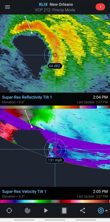
Last post for now from me but if you have Radar Scope, the velocity imagery for the eyewall is now starting to show on radar. Being mindful of range folding (the purple you see in the image in the ring shape is range folding) and beam height, the right front quadrant shows a broad area of 115mph winds with a small pocket maxing at 131mph probably in a mesovortex. Beam height at that distance is 24k feet, lol, so that ain't mixing to the surface . But, that's still an impressive measurement and is above what I believe delta was at on its approach for the same approximate height. Indicates the system is well organized and not falling apart. MU
-
Aircraft data: 975 mb (down 2) 93kt wind btm 150m in SEeyewall. That would imply probably 97kt winds in NE eyewall. Peak FL winds of 102 knots, which likely supports a surface intensity of 90kts. Eye is *open* to the NW-W, and is 24miles in diameter. MU
-
Katrina was slower, much much MUCH bigger, and New Orleans didn't have the protection system they have now. After Katrina they made major design changes to all kinds of things. This is a strong hurricane hitting a major city, it will do damage. But it will do less damage than Katrina...and such would be true even if they were the same in every way...size speed strength, because NOLA has now redesigned their city to better withstand a Katrina. The similarity is simply that it's another hurricane poised to directly impact the city. That's not to minimize it, just, Katrinas and Harveys.. those are a really rare type of event. MU
-
Collectively, wow. I agree, NE eyewall pass will be impressive. Though the winds there that got sampled are still getting a boost from the fast forward speed of the storm (note the direction of storm motion compared to the wind barbs). Also want to know the surface pressure. Impressive. But, no storm jumps 25mph in 3 hours. It's landfalling in 6. Does anyone have an analog for that big of a jump that fast over eh waters? I don't! Remember that Cat 2 is still impressive here given the water temps, time of year, that none of the guidance except the extreme high end projected such an intense system. I think the consensus on the forum right now is that it's at cat 2 strength. It's going to run out of ocean before it can hit cat 3, but honestly even I am surprised how well this is holding together and strengthening so close to landfall. MU
-
I try not to focus on minute-by-minute forecast changes based on how the storm looks at any given moment. I said this yesterday when I said I thought this would become a cat 2, and I'll say it now: I do not see dry air entrainment. The radar from klix shows a well organized system with several well formed curved bands. Better organized than some stronger wind-speed storms earlier in the season. Right now the eye is starting to show again. A hurricane is a well organized collection of thunderstorms. They pulse. Look at trends over the course of a few hours and don't get too bogged down by looking one way now another way now. Landfall intensity I think will be a function of shear. So far, shear has stayed low. 81-84 in this environment for water temps is fine for maintenance with low shear. Right now the storm is still over slightly warmer waters. I am guessing that that is what the 06z dynamical models picked up on because the structure of the system in said models depicted a relatively symmetrical storm, which implies low shear, and we do still see that now. The thing isn't on land yet and it will inevitably look different in 2 hours than it does now. For that reason, don't count the storm out without a clear eye, and don't assume if an eye clears now that it means RI. It's still strengthening right now, it will level out at some point close to landfall. I still say Cat 2 is likely as a peak intensity--low end Cat 2. Good upper divergence, low shear, not doom level water temps. Marginal 100mph storm. This is a good example of the difference between fast uniform flow and strong shear. Overall the storm is very short on time to change much. It isn't going to become a cat 3 and it isn't going to collapse into a tropical storm. What IS important to note is that a strengthening or steady state tropical system does mix down winds easier. So there's a difference between a weakening 100mph storm and a strengthening 90mph storm. The strengthening 90mph does more overall damage (potentially, I'm postulating here so if anyone thinks that's incorrect please let me know)...my logic is: you have the back side to contend with too and it takes longer to swing the pendulum the other way. We should be able to see the eyewall circulation on radar in an hour or two. MU
-
I mean, it's relative. The purpose of the flights is to provide data to the nhc and for forecast models to improve predictions. Hurricane forecasting is a national security issue. Hurricanes cause potentially billions in damages, and can kill a lot of people if the wrong forecast is given and people aren't prepared. Aircraft are useful when storms are changing intensity, speed, direction, and when the track is uncertain. Zeta is not really in those categories. Because of Zeta's speed, the models are in very good agreement on the track. We know 95% CI where this is going to go. Separately, whether this is a 90mph Cat 1, a 100 mph Cat 2, or an 85 mph Cat 1 at landfall...the impacts to New Orleans will be the same. Finally, they *are* flying enough missions such that there is basically an updated in situ measurement for every 3 hour forecast update. They don't have a plane in every moment because it isn't needed. It won't affect the forecast that's being issued. As the storm closes in on the coast, buoys and land based radar also helps provide more data. There is no budget cap for hurricane hunter missions. They just fly what they need to fly based on what nhc asks for. They'll have an updated in situ measurement before 2pm and that's really what's important at this point. MU
-
I have a few thoughts this am. #1 As the storm approaches the coast we'll start being able to see the eyewall on KLIX radar. As always this is another tool in our toolbox to see the structure and intensity of the eye and any associated mesovortices and their qualities. #2 The physics suggest that as we know, shelf waters cool near the coast. They are however still warm enough to support tropical systems, 80-81 near the coast. However, the storm will be moving very fast, and upper level divergence is solid. As a result, weakening will not be substantial. I am curious why both the 06z HWRF and HMON *both* show strengthening to landfall. That's odd. To ping off of Windspeed--at the moment, the data suggested a pause in the strengthening process. The storm has ~10-11 hours to go before landfall. The eye has become harder to see on recent satellite imagery, and convection is currently more asymmetric. Hurricanes go through pulses of convection so this isn't an immediate flag that strengthening is over. The storm may wrap convection around the eye again and become more symmetric. Moreover, the storm had excellent sat presentation overnight that would make you think it was a cat 2, but the hhunters didn't find those winds. Conversely, delta didn't look good on satellite a lot of the time but had potent winds. It looks to me based on the absolute most recent pass by the aircraft that winds have come up, and fixed geopotential derived surface pressures are down a touch from the last pass. And, to confirm that, just now, yeah, the plane shows pressures are down again now to 977. New vdm, closed eye, 24 miles, max fl winds steady at 89kts, estimated max surface winds of 70kts (previous vdm had those at 58kts). The sonde in the NE eyewall has 75kt winds in the lowest 150 meters. This is down by a knot from the last sonde through the NE eyewall and approximately steady. MU
-
Hhunters data is back up again now and they appear to be heading back through the right front quadrant right now so expecting this to be the highest windspeed pass of their pattern. Last pass through did bear out that wind speeds had gone up a bit. Latest VDM reported 66kts peak fl winds. I feel like 70 should be easy to exceed with the current presentation but, I suppose this is why we have the planes haha. MU
-
I agree with Windspeed's statement on landfall in large part. I think as with many things, stronger peak equals stronger arrival...BUT, in the same way that I think the current environment is strongly favorable for strengthening, I think the near-coast environment is pretty clearly not. The upper level pattern will be favorable and that will keep the system stronger than it might otherwise be, but it's hard to expect it to hit at peak intensity. That said, it may not weaken as much as we think it should--so whether or not sub-970 is possible at landfall is really a question of what it peaks at. It won't be in a hostile environment, just not a great environment. The question isn't, can it strengthen, it's can it hold together. The guidance is pretty solid in saying, "hey I don't think this is going to weaken a ton". It's saying that expecting a tropical storm, not a cat 3, so take that fwiw, but I do trust models to do OK with their upper level dynamics. Either way my feeling is, follow the physics. Models are guidance, not gospel. Helpful tools, show trends and tracks...but if you see a duck and the models say it's a cow, I'm going to treat it as a duck. I buy trends...that it won't weaken close to landfall a ton, but I also think the stronger it gets, the harder it will be to sustain that strength. In other news, the current ADT CI number is 3.0, estimated Vmax 45 knots, and it has the weakening flag ON. This is why I don't put tons of stock into automated dvorak numbers. Sometimes, very useful. Other times, not so much. Separate aside: I'm not sure what's up with the AF hurricane hunters the last few days. Last night it looked like they turned back after flying out for around 45 minutes, today data reporting stopped after around 20 minutes of flying from the base. Unusual. Also unfortunate since it's a useful way to monitor the overall environment. MU
-
Honestly, I'm going to go crazy and forecast this thing becomes a moderate Cat 2. None of the intensity guidance shows that, and I care 0%. The environment is excellent and I don't see dry air entrainment. The eyewall that's developing is solid, and I actually think the outer bands are helpful in keeping the interior of the system more stable. Less chance for some unknown shear to work in, less chance for extra dry air to work in. Whatever happens here, it will absolutely beat the intensity guidance. As for why the guidance is low, few possible reasons but frankly my best guess is low initial intensity. I've watched the guidance forecasts all season and they rise and fall in line with the ingested initial intensity. The thing is, it does NOT take THAT much to get a storm to grow stronger in a low shear, high water temp, moist environment, and you have better than chance odds by betting above the model consensus. If the eye feature closes off, which it looks poised to do, ya know, go nuts. As I've said all along, I'm definitely most interested in what this thing does inland when it phases with the continental low ejecting from the rockies. Very Isaias/Sandy-esq in the sense of baroclinic interaction maintaining strength for a LONG time. This storm won't produce 40" in a single spot, but the phasing is going to mean tens of millions of americans are going to see significant impacts from these storms. 2, 4, 6" of rain, some areas a couple feet of snow...these are large totals and will cause widespread spatially, but not dense, power failures, flooding, wind damage, etc over a HUGE swath of the eastern CONUS. Obviously you're also ingesting a bunch of vorticity, and if you take that, add some moisture, jet streak and a strong llj, you'll see a touch more tornado potential than with your average hurricane. Whenever a barotropic system phases with a baroclinic system, things get interesting. MU
-
I second this sentiment. Even before this thing consolidated, the modeled moisture and vort interaction with the trough and subsequent merger into a coastal low type system seemed meteorologically-interesting. You have a potentially strong moisture rich TS interacting with a digging large scale, fall/spring type baroclinic zone. It seems a bit like a Miller A in some ways. In another way it reminds me faintly of Isaias earlier this year which stayed rather strong once inland due to baroclinic interaction. Regardless, that was and is the thing I'm really going to be most interested in watching play out with this thing. As for Zeta and its direct impacts, it really has a great environment right now. The faster it gets organized, the more it can feed off bomber ssts, and the stronger it would be at peak strength. Given the marginal environment in N. Gulf, the degree of strengthening attained in Yucatan will portend the ending strength of the likely-weakening system at landfall. Like Delta, current environment would favor RI if the storm already had its circulations well aligned. You wouldn't see Delta-level strengthening which was 75kts/24hrs, but RI is 30kts/24hrs, and the environment is clearly capable of that if a well organized system were feeding off of it. You can clearly see available energy is very high due to the persistently strong (aka high topped/cold topped) convection on imagery, shear is low, and upper level outflow is good. But, thus far, Zeta is still trying to organize and as such, its center is chasing the strongest convection and not well defined or well fixed. It will be interesting to see what hurricane hunters find on their next flight. My guess is, they find it's stronger than they think. No scientific explanation for that, just seems that whenever the hhunters go into a storm, it's "significantly stronger than satellite and other data had suggested", lol. Once it better defines its center and that center begins getting steered some direction, we'll see more steady to quick intensification until the storm reaches the gulf. MU
-
Subsidence? Turbulence? Overturning of the pbl as it switches to the nocturnal scheme? Dry microbursts driven by ingest of dry air? Could also be similar to other hurricanes where the segment over water maintains some intensity for a bit even when the center has moved inland. You've also got strong mid level and upper level winds, which at this point could play a role both in upper level mass transport and in the vertical wind currents in the storm. Not really sure which of those it is, if any, just sort of thinking out loud. Your basic physics for this requires sinking air to transport the momentum/energy from the 925-850mb layer to the surface, so just thinking of what would do that without precip. MU
-
Okay that makes more sense. What you had said in the OP with the link confused me a bit because I thought you were implying those were predicted values, e.g., forecasted, not just the regular tides. MU
-
That comparison is a bit misleading. Looking at the "predictions", all of those observing sites near the coast "predict" ZERO flooding. That is incongruent with the storm surge forecast. That seems like the "no storm" prediction to me, so I don't think the water levels are 4' higher than the storm surge warning indicates. Still, a good link with good data. MU
-
Actually, Laura was a bigger storm. TWC did a direct overlay a couple hours ago, the hurricane force wind field, and the TS wind field, were larger at landfall with Laura. Delta is still an above average sized hurricane though. The storm is tracking at a different angle and speed, that is why different areas are going to see the eye. With laura the eye came straight in, rather than diagonally. W.r.t the landfalling major thing--I don't think almost anyone thought this would hold up as a cat 3 that well given the hostile environment. The consensus was upper 2, it may end up mid or low 2, so, not that far off the mark. We are so used to seeing strengthening landfalling cyclones the last few years in pristine environments that one that behaves in a weakening manner is almost beyond comprehension and lends itself to forecasting a high intensity bias. The nhc, most people on here, figured it would be a cat 3 in the middle gulf--it was--and would drop intensity on approach to the coast--which it is doing. E.g., this isn't earth shattering and unexpected. It would have been surprising if it HAD stayed together given that the entirety of the guidance weakened it to cat 1/2 at landfall. Looking at the satellite and radar presentation though, that seems to be too little, too late in terms of impacts (which also is as expected). I think 100 at landfall is probable, though it may be marked at 105, however I think the highest observed gusts will be mid 90s because I don't think the odds are high of an observing station being perfectly situated along the coast to capture the absolute max winds this thing produces anywhere and obviously once inland you immediately deal with viscosity effects that bring any storms wind speeds down, regardless of cat + weakening trends and SFMR measurements are lower than the estimates based on FL winds. I can see from the radar that Beaumont, Cameron, and Lake Charles, are already seeing damaging winds and flooding rain probably entering into and damaging already damaged structures. MU
-
2020 Atlantic Hurricane Season
Moderately Unstable replied to Windspeed's topic in Tropical Headquarters
Well, it is 2020, so, hey, ya never know. I think this may be a bit more reflective of the inherent limitations of the ACE metric than an indicator that the season wasn't hyperactive. With any index, you almost invariably have some kind of bias. If you weight by, say, rainfall produced, you'll get a different measure than using wind speeds. If you measure by number of hurricanes landfalling on the us coast, that's again another number. For the us population, I'd say that last one probably makes the most impact. That said, it is notable that despite this season surpassing 2005, which had the 2nd highest recorded ACE since record keeping began (250), this season has seen a prodigious number of storms but very much lacked in terms of intensity. The ironic thing here is what happened is antithetical to the current going climate change hypothesis (of which I used to be a researcher). The modeling shows, generally, less storms, but more intense ones. Though lately there's some back and forth on that. This year we've seen more storms, but less intensity. I don't view that as an indicator of lack of climate change though. More that weather doesn't exist in a vacuum. Developing La Nina and various teleconnection phases play a role. In any case, I think it's likely safe (but 2020 again so, lmao, who knows), to assume that Delta is the last of the long track high-impact majors of this season. I don't think we can say with certainty it is the last major *period*, as the Caribbean is still warm as you allude to. We also can't say it is the last US impacting storm. Sandy was October, Michael was October. The reason it could be the last major impacting the us has to do with the water temps along the gulf coast and Florida. If another major hit it would need to hit Florida, probably the southern part, so it's statistically unlikely just because of the number of things that would have to go "right". You also still can't totally count out the mid-atlantic. We still have a ways to go, so a useful metric if one were able to find it, would be seeing comparable average and hyperactive ace scores *to date*, rather than for the season as a whole. That would better articulate how above/below we are tracking relative to a hyperactive season based on wind intensity. The thing that retards long track cape verde storms, and storms in general, this time forwards, is shear. Certain parts of the ocean are still warm enough to support tropical development and will remain so, likely, for a couple more months. In my research experience, things like the MJO and other teleconnection phases are useful when it comes to figuring out when the jet stream will be more zonal, more meridional, faster slower. Thus, it is conceivable to hit 152 still. One notable thing here is that the ace index biases towards intense cyclones, since the wind speed is squared in the calculation. That means the ace score is parabolic (exponential, though I like saying parabolic as it is more specific) with increasing storm intensity, not linear. I'm not sure that's the *wrong* approach to take (you have to weight things somehow), but, I think this season will be considered hyperactive regardless of the final ace score. MU