
WhirlingWx
-
Posts
404 -
Joined
-
Last visited
Content Type
Profiles
Blogs
Forums
American Weather
Media Demo
Store
Gallery
Everything posted by WhirlingWx
-
And then Orlando gets rocked by a damaging tornado from Cristobal's outer bands. Heavily populated area and reports of roof collapses but hopefully no casualties. Edited to link a video of said tornado taken from Twitter... Debris lofted to nearly 20k feet as well per CC https://mobile.twitter.com/News6Justin/status/1269415099254673408
-
If the Interior NW were to stop our May moderate risk drought the 2nd to last day before the end of the month, it would be fitting for 2020. ...THERE IS AN ENHANCED RISK OF SEVERE THUNDERSTORMS NORTH-CENTRAL OR TO CENTRAL/EASTERN WA... ...SUMMARY... Scattered to numerous severe thunderstorms, offering destructive winds and hail, are most likely between 1 to 10 PM PDT over parts of the interior Pacific Northwest, east of the Cascades. ...Interior Northwest... Primary change is to increase tornado probabilities across parts of central OR. Categorical outlook is largely unchanged. Consideration was given for an upgrade to Moderate Risk in the western portion of the Columbia Basin. Concerns over the spatial extent of the severe wind coverage preclude further upgrading at this time. Thunderstorms will likely intensify after 19Z in a zone of strong deep lift across south-central OR, ahead of an ejecting shortwave trough. Here, robust diabatic heating is underway amid a plume of low to mid 50s surface dew points. This will support a narrow corridor of modest buoyancy with MLCAPE reaching 750-1500 J/kg from central to northeast OR. Greater buoyancy is expected to develop towards 00Z farther downstream in eastern WA to northwest MT where mean-mixing ratios are higher. Surface-based effective-inflow parcels will exist on the west side of the surface front, where low-level winds will be veering with height, hodographs strongly curved, and deep shear relatively maximized. With low-level vorticity also maximized in the frontal zone, multiple supercells are expected. Though the environment generally favors higher-based convection, initial supercells should have the best potential for large hail and a couple tornadoes between about 21-23Z. As the supercells spread rapidly north-northeast, at peak boundary-layer heating over the Columbia Basin, upscale growth into a forward-propagating MCS appears probable. This will increase the potential for severe wind gusts, some of which may be significant, given the favorable combination of steep lapse rates and moderately large buoyancy. Overall setup appears likely to yield a swath of severe wind in the Columbia Basin from north-central OR across parts of central and eastern WA before the MCS moves into British Columbia.
-
https://mobile.twitter.com/pmarshwx/status/1266745452009046019 Appears this may be the only comparable outlook, a very unusual setup nonetheless
-
Ah, thank you. I see, and again we're shown how much subtle details matter. Looks like the localized backing of winds and enlargement of the hodographs (among some other ingredients you mentioned of course) really helped turn that storm into a powerful tornadic supercell. And honestly 35 knots of bulk shear sounds like more shear than there's been in most of the setups so far this month, I could be wrong though.
-
Deadly EF3 tornado confirmed from Louisiana yesterday... The atmosphere can really surprise us. Does anyone know what the environment in that area was like at the time of the tornado(es) there? I basically paid no attention to it considering it had been a general t-storm risk area
-
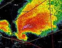
For that storm https://mobile.twitter.com/BraxBanksOKWX/status/1262205919586377730
-
Now got a tornado warning south of Omaha, NE
-
Wowie, tornado warnings for 5 different cells/areas of rotation in the Arklatex region now
-
Yeah pretty interesting for the time of year. I rarely chase and don't have much experience, sort of an armchair kinda person, but I've been looking to go chasing more often (mostly local) and darn I didn't anticipate this; it's only a couple hours away from me. The tornado-warned storms are pretty much lined up from NW to SE, one could just hop down each cell as they see fit (but of course the decision on when to change storms would require more effort and thought). On the other hand, the terrain isn't too ideal in that area and lots of rain happening so I guess that takes away from the likelihood of having a nice view.
-
A few tornado warnings in effect in parts of NE Texas and SE Oklahoma with the area of low-topped supercells there in the slight risk area
-
Picture of tornado near Red Rock, TX https://mobile.twitter.com/JohnRichTX/status/1260228858223251461
-
I guess I could post this here then... Confirmed tornado SE of Austin a while ago and two TOR warned storms continue in that general area. SPC says watch possible and central TX will be upgraded to slight risk. And nice shots Quincy! Bummer that you missed out on Amarillo but cool structure on your storm nonetheless.
-
Central/Western Medium-Long Range Discussion
WhirlingWx replied to andyhb's topic in Central/Western States
Could end Kansas' tornado drought this year if we do get some action there
