

40westwx
-
Posts
629 -
Joined
-
Last visited
Content Type
Profiles
Blogs
Forums
American Weather
Media Demo
Store
Gallery
Posts posted by 40westwx
-
-
7 minutes ago, yoda said:
Tasty
I dont see why people are worrying.. unless you live in So MD, this storm is going to be a proper mauling.
-
9 minutes ago, DCTeacherman said:
I’d be so pumped if we get an event that is snow —>mix/rain —> CCB crushing. Gimme an inch or two on the front and then 3-6 in a short span on the back and I’ll be satisfied.
Jan 2011? That was one of my favorite storms!
-
20 minutes ago, Weather Will said:
WB 6Z v 0z 925


you see that coma shaped area of below 0 to the south and west of DC.. I think the model picking up on the dynamics of the system.. it looks like thats where wind shifts around to the north and banding sets up..
-
 1
1
-
-
2 hours ago, MillvilleWx said:
The 850-700mb frontogen on the 06z GFS is otherworldly. Whoever stays all snow with this system is gonna shovel well over 12". Mark my words.
Crazy aviation shift over here this evening, so bare with me.
We need more analysis like this.
-
1
-
-
56 minutes ago, MillvilleWx said:
This is how you get your 2-3"/hr snowfalls. 7H and 85H frontogen with this setup is silly.
oh yeah!
-
53 minutes ago, losetoa6 said:
Latest Gfs run is a pure money shot

If I were you I wouldnt worry about a thing... this is basically a lock for Carrol County! Even with the worst run (18z gfs) you still got warning level snow!
-
51 minutes ago, nj2va said:
I won’t get into the intense banding that the 81 corridor/ish crowd will get but can make up for some of that with better ratios. Phin also pointed out the orographic enhancement that the globals won’t pick up on yet - and the upslope snow showers that will continue after the coastal moves away. But i think the bullseye will be somewhere in the 81 corridor-ish.
This will be my first coastal since buying the place in late 2016 so will be interesting to learn climo out there for these events.
Lucky for you, there will be more snow in Oakland this winter
")
Its pretty amazing that Deep Creek hasnt seen a big coastal since 2016... You would think that would have been a near miss/ rainer for the Cities that dumped up there.. but that tells you just how bad it has been..
-
19 minutes ago, Chris78 said:
That's crazy. We're still like 90 hours away from potential flakes flying.
CWG should be taking notes. At least accuweather has some balls to put a real forecast out there!
-
4
-
 2
2
-
 1
1
-
 2
2
-
-
13 minutes ago, Ji said:
lol brutal cutoff from HECS-MECS-to travelors advisory
I lost 13 inches that run
-
1
-
-
9 minutes ago, BTRWx's Thanks Giving said:
Probably too early for those specifics.
their forecast is just silly.. I know @usedtobe is the primary contributor but if I were them I would title the headline "Foot of snow possible for DC". They are way too conservative. Just let it rip.. have fun with it!
-
17 minutes ago, mappy said:
I got a sneaky 5-6” in one event last winter, so I’ll take a warning level event.
I couldnt agree more.. And if you live in Southern MD or even DC.. just book a staycation somewhere!! Hunt Valley is very close to Oregon Ridge.. stay Wed night and sled on Thursday! This is an easy chase
-
6 minutes ago, CAPE said:
Holy crap with the snow maps lol. We should have a thread for that.
I thought this was the thread to show snow maps?
-
2
-
-
7 minutes ago, BTRWx's Thanks Giving said:
I think it's better to compare 12z to 12z and 0z to 0z.
nope.. that comparison is fine
-
1
-
-
59 minutes ago, PhineasC said:
You new here?
@mappy kicked me off and then I created a new account... but no.. why do you ask
-
7 minutes ago, Always in Zugzwang said:
Here's how the last couple days of model runs seemed...
--00/12Z GFS: Total beat-down, pummeling, crushed!
--00/12Z CMC: Hold my beer...!
For anyone north of Baltimore, to me it seems fairly locked in at this point. We are just at 96 hours.. if we get one more day of model runs like this.. and it fails.. we are looking at a huge bust.
-
8 minutes ago, MD Snow said:
For those in the cities and especially s/e of 95... We better hope this thing doesn't tuck anymore or we'll be dealing with a quick 2-4" followed by a crap ton of rain.
Not sure if there is a correlation but it does seem that as the models have become more amped for Monday the Wednesday storm is closer to the coast and the warm push is legit.
no
-
Its gonna stay cold for a while too.. so this will stick around
-
We should actually play this bingo thing
-
7 minutes ago, NorthArlington101 said:

Bingo!hilarious!!!
-
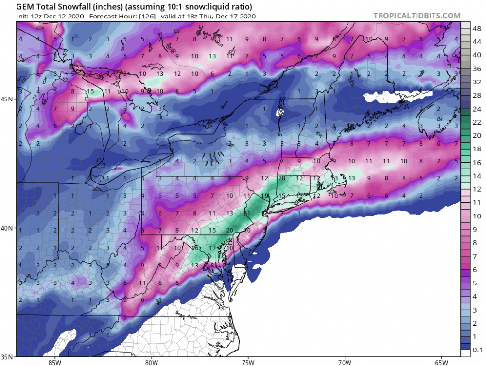
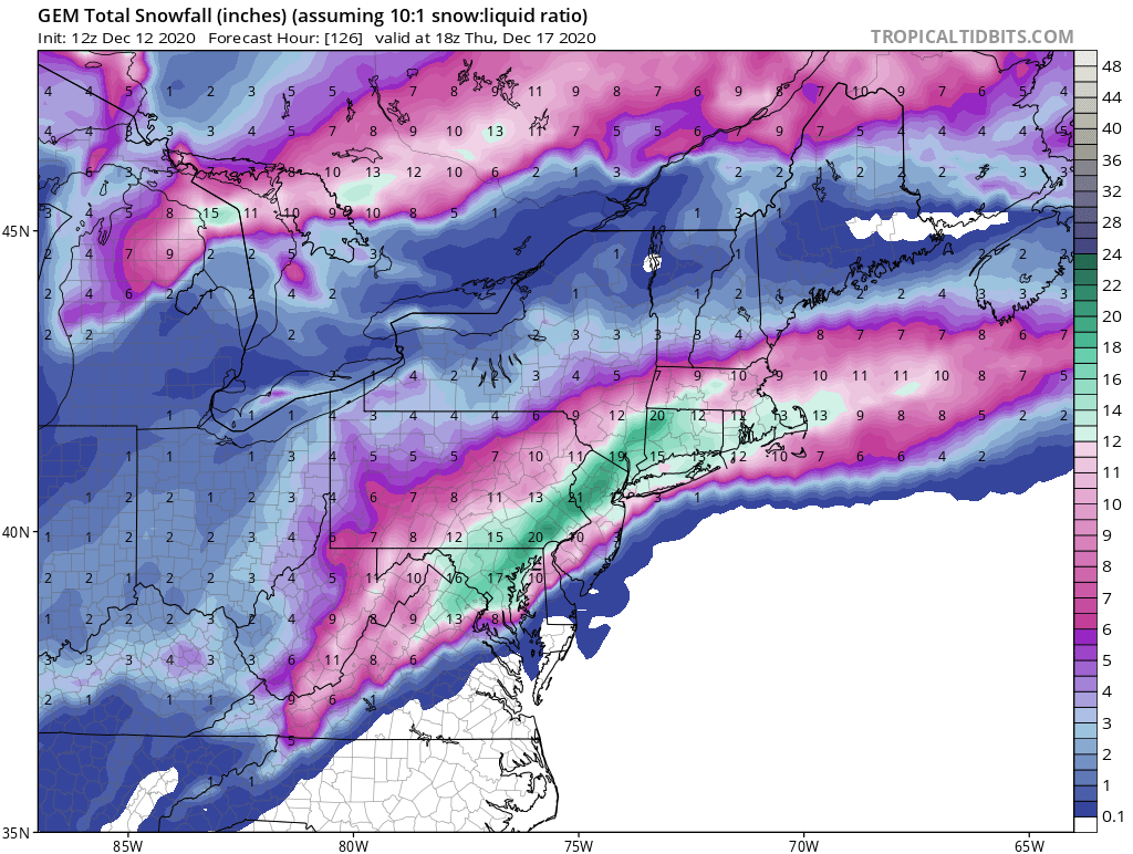
DecemberDCBaltimoreDulles16.6"200920.4"196624.2"196616.2"196220.1"200921.4"200916.1"196617.1"190415.9"196914.5"193215.6"196014.3"196213.2"1904,194514.7"193211.9"1982
-
2
-
 1
1
-
-
Verbatim this would be one of the biggest storms in December in history.
-
2
-
-
13 minutes ago, WxWatcher007 said:
Antecedent cold isn’t a concern in this event outside of the usual SE spots imo. Here’s the 00z EPS high temperature 50th percentile chart.
Forget about the verbatim numbers for a second and look at the wedge of cold nestled all the way into upstate South Carolina. That’s a very strong CAD signal.
Again, this is the ensemble so it’s not a random drawing like an op run can be. The cold is in place in most locations as the storm is arriving. Now that doesn’t mean mixing won’t happen or that things can’t trend warmer at the surface or aloft, but that’s a great signal right there.
The source of the cold air is significant also.. Wednesday morning might be the coldest day of the year for many in the NE. It might be in the low 20s for @psuhoffman when its starts snowing.
-
6 minutes ago, WxUSAF said:
I didn’t want to bring it up...but 4” soil temps are torched. White rain inbound. Take the snow depth product and divide by 5 if you want a realistic accumulation estimate.
Hold on.. didnt it snow like a foot in Denver earlier this year on the same day it was 80 degrees?
-
17 minutes ago, H2O said:
None of this really matters anyways. It won’t snow much Wednesday when temps this weekend will be 60s
oh shit.. I didnt think of that...


December Medium/Long Range Discussion
in Mid Atlantic
Posted
I was in Petsmart shopping and I am pretty sure it snowed 2 inches while I was in there... I had to push a guy out of the lot cause he had rear while drive... that one and the Valentines day one a couple of years later were insane...