

40westwx
-
Posts
629 -
Joined
-
Last visited
Content Type
Profiles
Blogs
Forums
American Weather
Media Demo
Store
Gallery
Posts posted by 40westwx
-
-
6 minutes ago, DanTheMan said:
Good game Ravens people.. You got the win tonight but we will no longer be two free Ws every year anymore
Guess what.. the Ravens have the tie breaker and the browns could definitely lose to the steelers and the ravens could definitely win out.. so thats probably whats gonna happen
-
34 minutes ago, nw baltimore wx said:
I don't think it's that bad. They need to decide their identity. If you're going to have Lamar as your quarterback, then you have to use his strengths at the risk of injury. They backed off earlier in the year maybe to keep Lamar healthy, and they were not as effective. If you want a solid, NFL quarterback, McSorley could be your guy. But get him some receiver help.
Just my 2 cents.
What are you talking about? Lamar is the MVP of the league and he just showed you why.... he knows how to win.. he has killer instincts.. that was the best game of his career. Seattle last year is number 2.
-
Just now, WxWatcher007 said:
Wait a minute, what was the line and O/U? Was that a bad beat? That'd be perfect

Thats the first thing I thought when I saw the safety
-
1 hour ago, ravensrule said:
LJ SUCKS. Two simple wide open passes and he isn’t close on either one. Both would have been TD’s.
Shut up
-
Just now, DanTheMan said:
The team from Cleveland
good one.. anyway.. Lamar is like 2 for 4 for 20 yards and is dominating this game.. so I very happy with what I have seen so far
")
-
9 minutes ago, DanTheMan said:
Our defense dude..bleh final 2 minutes
Who are you rooting for?
-
4 minutes ago, PhineasC said:
The NAM says this isn't even a MA forum storm. It mostly rains on the parts of the forum where 95% of the posters live.
What are you looking at?

-
 2
2
-
-
5 minutes ago, mappy said:
bUt SnOwMaPs!
F it my in laws got 50 inches on that run.. I am gonna head up there for a sleep over
-
 1
1
-
-
1 hour ago, WxUSAF said:
WBAL had a pretty good map earlier, at least prior to any 12z/18z changes. I don't get just ripping the RPM snow map as a forecast. WJZ has this pretty terrible looking maps, but I guess 4-6" around Baltimore is reasonable.
I am waiting for Marty Bass in morning.. that guy is maybe the best forecaster in Baltimore History!!!
-
 1
1
-
 1
1
-
1
-
-
19 minutes ago, BristowWx said:
Top 5 for that date in Dec maybe? That is plausible.
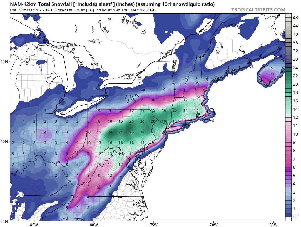
DecemberDCBaltimoreDulles16.6"200920.4"196624.2"196616.2"196220.1"200921.4"200916.1"196617.1"190415.9"196914.5"193215.6"196014.3"196213.2"1904,194514.7"193211.9"1982 -
19 minutes ago, mappy said:
lol. No it doesn’t
The last four runs have shown 8-15 inches at BWI. 15 would be a HECs for December. I think 13 would be too...
-
Just now, BTRWx's Thanks Giving said:
Nobody is getting a hecs.
The Euro shows top five for BWI. Thats a HECs
-
1
-
1
-
-
5 minutes ago, Climate175 said:
I won't as I remember it's only mid-December and I-95 and East is not climatology favored to get big snow at this time. If you're at those expectations, you can't be disappointed. If you having high expectations of a big hit of snow, then....
I have gigantic expectations. 12 out of 16 runs of the models have given me a HECs.
-
3 minutes ago, clskinsfan said:
The Euro has a better HP over the top. And if I have to have only one model in my corner for a storm I am taking the Euro every single time.
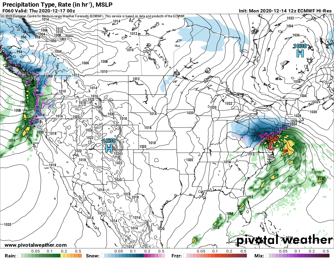
Lows are going to be in the mid 20s for many Tues night in to Wednesday.. that cold isnt going anywhere when the precips starts.. that HP is causing lows in the single digits and teens for folks just to our north.. thats some serious cold air. With a develop lp system to our south.. the prevailing flow means that cold air is going to be pulled down in to our region. Its only at the height of the storm that we need to worry about the column.. and even then it might be cold enough at the lower levels to support a sleet fest.
Think about this.. it almost snowed here today and it was like 65 degrees yesterday. We get a similar track on Wed and we have an abundance of Cold Air. Thats why I think the Euro is dead on with its tucked in low pressure and relatively south R/S line.
-
2
-
-
5 minutes ago, Imgoinhungry said:
What is euro keying in on that gfs is not? Colder temps? Which model typically forecasts temperatures better?
The euro is further north and stronger at hour 60 and it looks like it barely has flipped over at that point.. where as the GFS is further south and weaker.. but it is raining for pretty much everyone.

-
 1
1
-
-
6 minutes ago, BTRWx's Thanks Giving said:
Nope

That map isnt right.. you need to show the kuchera one.. it gives you more snow and the more snow the better
-
2
-
-
10 minutes ago, Deer Whisperer said:
This science seems solid
I am using the @Jebman algorithm
-
2
-
6
-
-
I want you all to be prepared for the greatest succession of model runs in Mid Atlantic snow storm history.. over the next 36 hours we are going to see a slow and steady shift to colder temperatures.. all of you all teetering on the brink will see you 1-3 turn in to 2-4.. then to 6-8 and then.. the ever important 8-14.
This shit is happening
-
2
-
10
-
-
Just now, losetoa6 said:
Been S+ for a bit . Around .75"
Maybe it rotates down to us!
-
I got a pinger in Catonsville
-
1
-
-
4 minutes ago, WxWatcher007 said:
Oh please. This is tame right now. I’ve seen far worse.
Everyone is in denial right now.. if the euro trends worse, you better your cleaning crew ready. Its gonna be a blood bath
-
1 minute ago, Cobalt said:

Can someone smart explain the lp difference here? Seems to be in a more realistic spot given the GEFS support.
The 12Z is about 75 miles to the west of the 6Z
-
LOL.. as I write that last message the GFS jumps inland about 75 miles from the previous run..
-
2 minutes ago, Warm Nose said:
Going strictly by personal experience I'd say it is likely that the storm is another > < this close miss. That's just living in the area for 25 years and knowing how these tend to go especially this early in the season.
you guys are not looking at the overall pattern.. which favors lower temp profiles.. March 2013 was a completely different set up. At 12Z Wednesday temps are in the low 20s throughout central PA and the core of the cold air mass is the coldest temps Eastern North America has seen so far this winter. We have a ~1040 HP system forcing that cold air mass in to our area.. I keep saying this.. but I really think we over-perform with temps!

December Banter 2020
in Mid Atlantic
Posted
this.. "If you want a solid, NFL quarterback, McSorley could be your guy."
I get what you are saying about the risk of injury... but your comment suggested that Lamar cant be a long term solution and that Trace is a better option.
Lamar lead the league in Touchdown passes last year...